


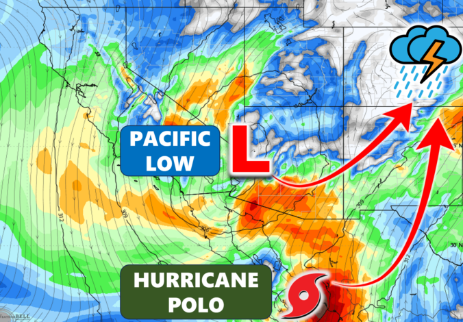
A slow‑building, tropical‑charged system is about to make its move on Colorado — and the setup behind it is far more complex than your typical late‑September storm. As Hurricane Polo’s remnants collide with a impressive Pacific upper‑low, the stage is set for a rare, moisture‑laden system that could deliver anything from a major rain event to a near‑miss for Boulder and Denver. We break down why the models are struggling, what the key track differences mean for your neighborhood, and where flooding and high‑elevation snow may become real concerns as the storm unfolds.
UPDATED Tuesday Sep 26 5:00PM: Updated rainfall forecast map and some wording to account for growing confidence the bulk of the storm will miss the Denver Metro area.
What You Need to Know
- 🌧️ Historic moisture setup: A Pacific upper‑low and Hurricane Polo’s remnants are set to phase over the Four Corners, creating an unusually deep tropical moisture feed into Colorado.
- 🌀 Track uncertainty remains huge: Model disagreement on Polo’s final northward push keeps the exact surface‑low placement — and the heavy‑rain axis — highly uncertain for the Denver–Boulder corridor.
- 📍 Metro area sits on the razor’s edge: A northwest track brings widespread 1–3″ totals; a southeast track limits us to just cloudy skies and scattered showers with less than 0.5″ of rain.
- 🌧️ Most likely outcome: Light–moderate rain for most of the Metro Wednesday–Wednesday night, with heavier totals (1″+) favored well south and southeast of Denver; northern Metro area may see very little.
- ⚠️ Flooding concerns: Flood risk peaks Wednesday into Wednesday night south of Denver. Watches include the JeffCo Foothills and Palmer Divide; any further expansion northward is unlikely.
- ❄️ High snow levels: Warm tropical air keeps snow levels at 10,500–12,000 feet; only the highest peaks see accumulation including up to a foot of snow in the southern ranges but minimal travel impacts at pass level.

Go Premium, get all the perks.
Daily Forecast Updates
Get our daily forecast discussion every morning delivered to your inbox.
All Our Model Data
Access to all our Colorado-centric high-resolution weather model graphics. Seriously — every one!
Ski & Hiking Forecasts
6-day forecasts for all the Colorado ski resorts, plus more than 120 hiking trails, including every 14er.
Smoke Forecasts
Wildfire smoke concentration predictions up to 84 hours into the future.
Exclusive Content
Weekend outlooks every Thursday, bonus storm updates, historical data and much more!
No Advertisements
Enjoy ad-free viewing on the entire site.
F
or nearly ten days now, we’ve been tracking Hurricane Polo and evaluating what its eventual inland remnants could mean for Colorado. That long, watchful stretch is finally paying off. All the ingredients are now converging for a potentially historic, highly anomalous rain event across the American Southwest — including a substantial portion of the Centennial State.
The Two Key Players Are Now Fully on Stage
GOES-East water vapor imagery Tuesday morning clearly highlights both dominant features:
- Upper‑low dropping south — A deep, cold-core low from the north Pacific has plunged southward and fully closed off, now centered over southern California. This feature alone would have produced a noteworthy multi-day precipitation event for Colorado.
- Hurricane Polo’s inland transition — Polo made landfall in the Baja Peninsula Monday evening. As of Tuesday morning, it still maintains low-end hurricane intensity, but weakening will accelerate as it moves inland into mainland Mexico.
The most remarkable — and most uncertain — aspect of this setup is how these two circulations will phase across the Four Corners region. The broad outcome has been clear for days: Polo’s remnant low will be absorbed into the upper-low, injecting a deep plume of tropical moisture into an already potent synoptic system. But the specifics of that merger are giving the models absolute fits.
Key questions remain unresolved:
- Where will the new surface low ultimately form?
- Where will the heaviest precipitation band anchor?
- How far north will the tropical moisture shield extend?
- How low will snow levels fall once the system matures?
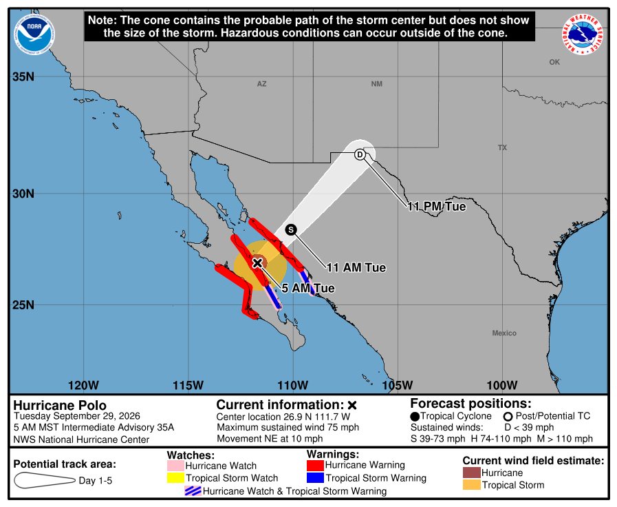
How the Merger Unfolds Matters Tremendously for Denver
Deep southwest flow ahead of the upper-low will sling Polo’s remnants almost directly into eastern Colorado by Wednesday night. At some point, the two systems will fully merge, Polo’s northward momentum will stall, and the combined circulation will consolidate into a broad mid-level low drifting east-southeast.
Short-range forecast animations show Polo’s windy core riding as far north as Pueblo before absorption.
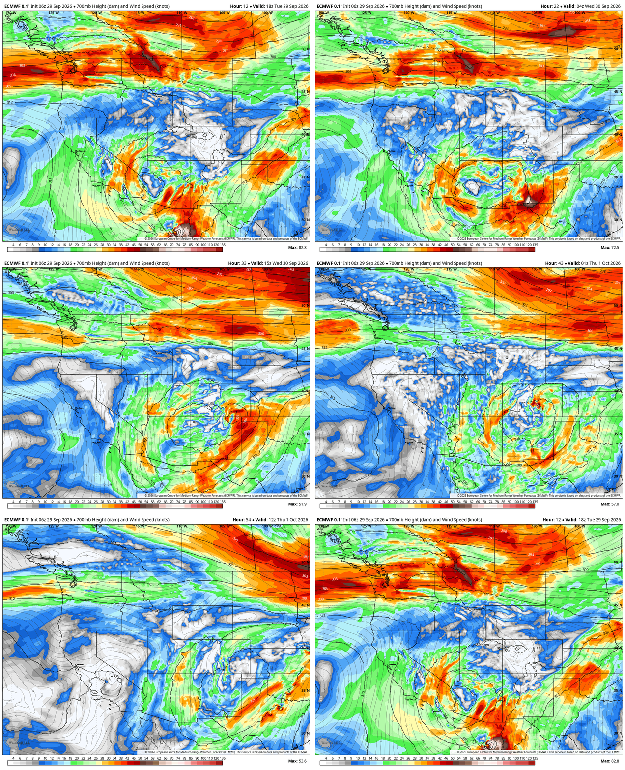
Meanwhile, the remnant surface low associated with Polo’s former eye is projected to reorganize somewhere in far southeast Colorado on Wednesday.
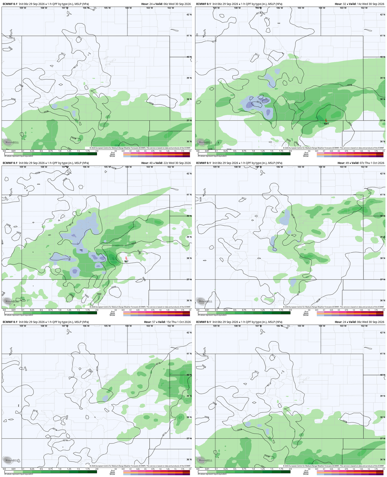
The exact latitude of Polo’s final push before absorption will dictate:
- The surface low’s final position
- The northward reach of the heavy precipitation shield
- The gradient between “major event” and “mostly clouds” across the Front Range
Model Spread Remains Large — Even This Late in the Game
Model differences regarding Polo’s northward push remain quite large, even at this late hour with the entire event knocking on Colorado’s door. Some models, like the Euro shown below on the left, believe the surface low will make it all the way into southeast Colorado near Pueblo. However, there’s just as many if not more that keep the surface low much further southeast in the Oklahoma/Texas Panhandle region, such as the GFS shown below on the right.
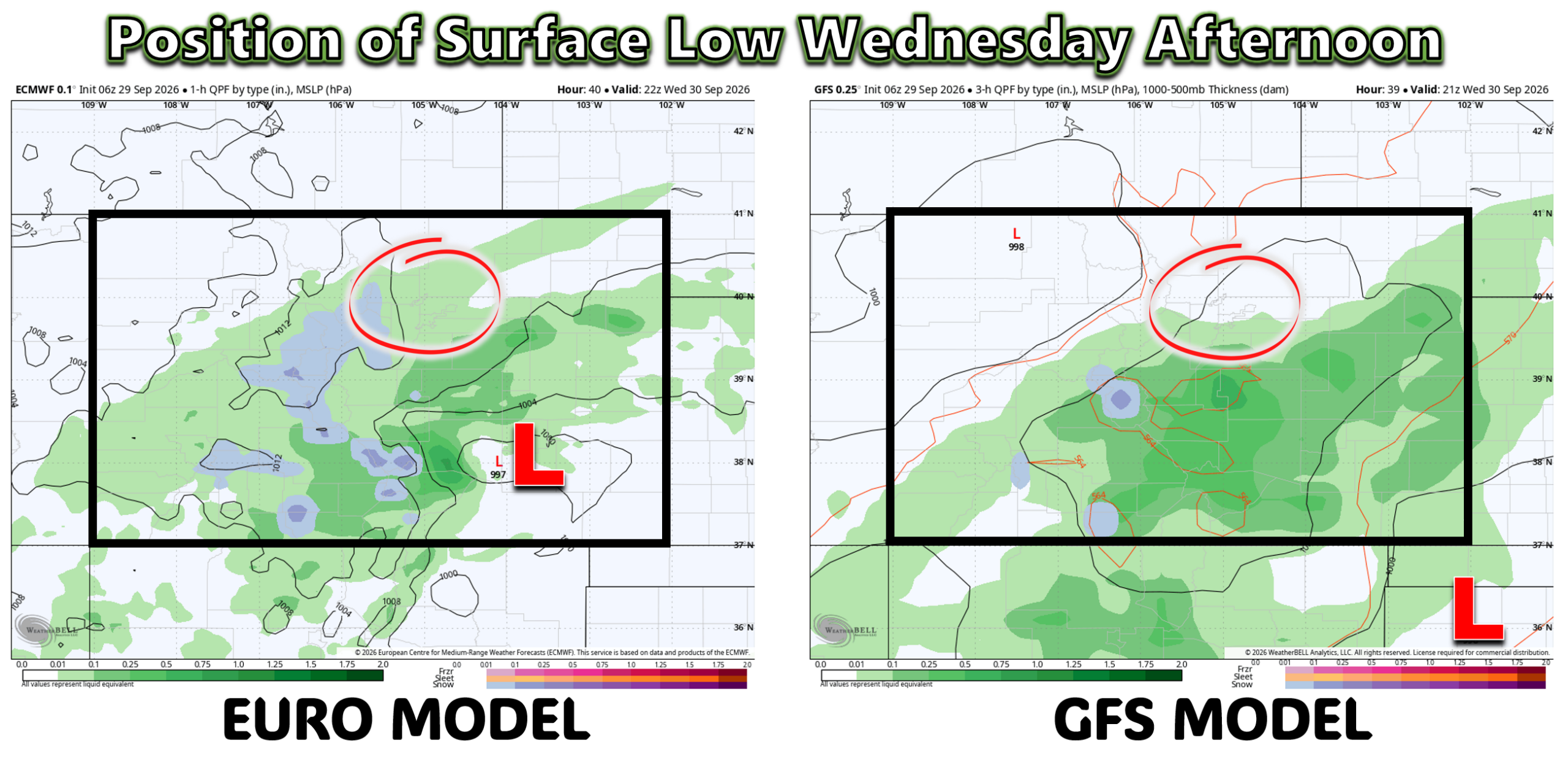
This positioning will have huge implications for the Boulder-Denver Metro area, which remains on the far northern fringe of the entire event.
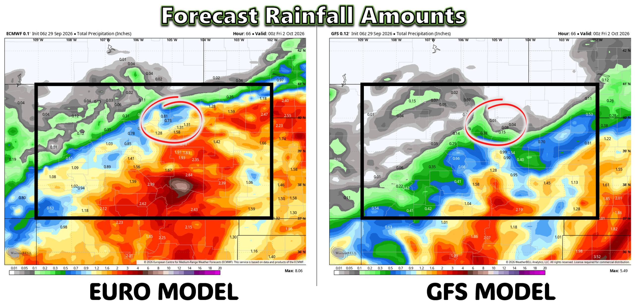
- If the Northwest Track Verifies: The shield of precipitation will engulf the entire Metro area with rain lasting ~24 hours and most areas getting over 1″+ of rain, with locally over 3″ in far southeastern suburbs.
- If the Southeast Track Verifies: The shield of precipitation stays mainly southeast of Denver, with our area getting lots of clouds and some showers, but generally everyone receives under 0.5″ of rain.
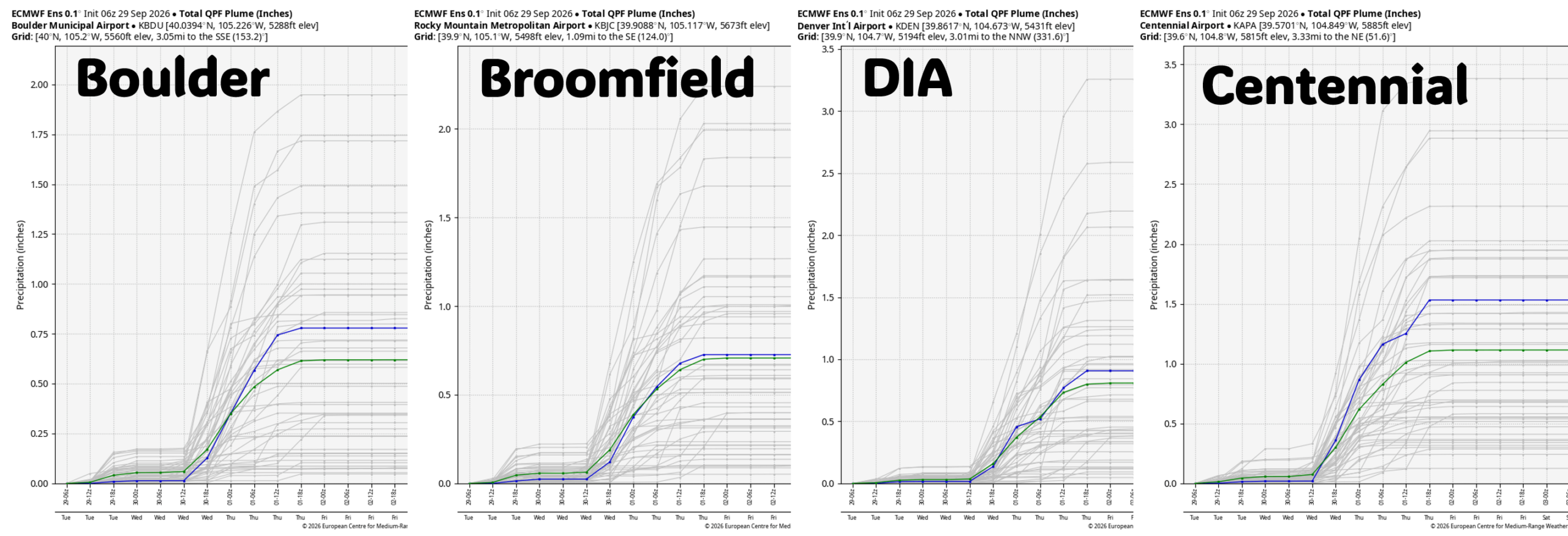
Ensembles — normally our go-to for clarity — are not helping. European ensemble members for Boulder, Broomfield, DIA, and Centennial range from near non-event to over 2″. The mean sits between 0.6″ and 1.1″, but the spread is enormous. The Euro has also been trending downward in recent cycles, so the final outcome will probably skew low.
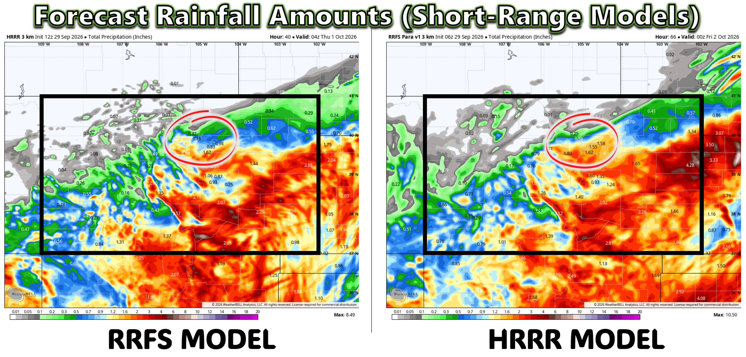
Short-range, high-resolution models aren’t resolving the uncertainty either. Boulder and Denver sit directly beneath a sharp north–south gradient in rainfall potential — a classic “knife-edge” setup.
Our Forecast Amid the Chaos
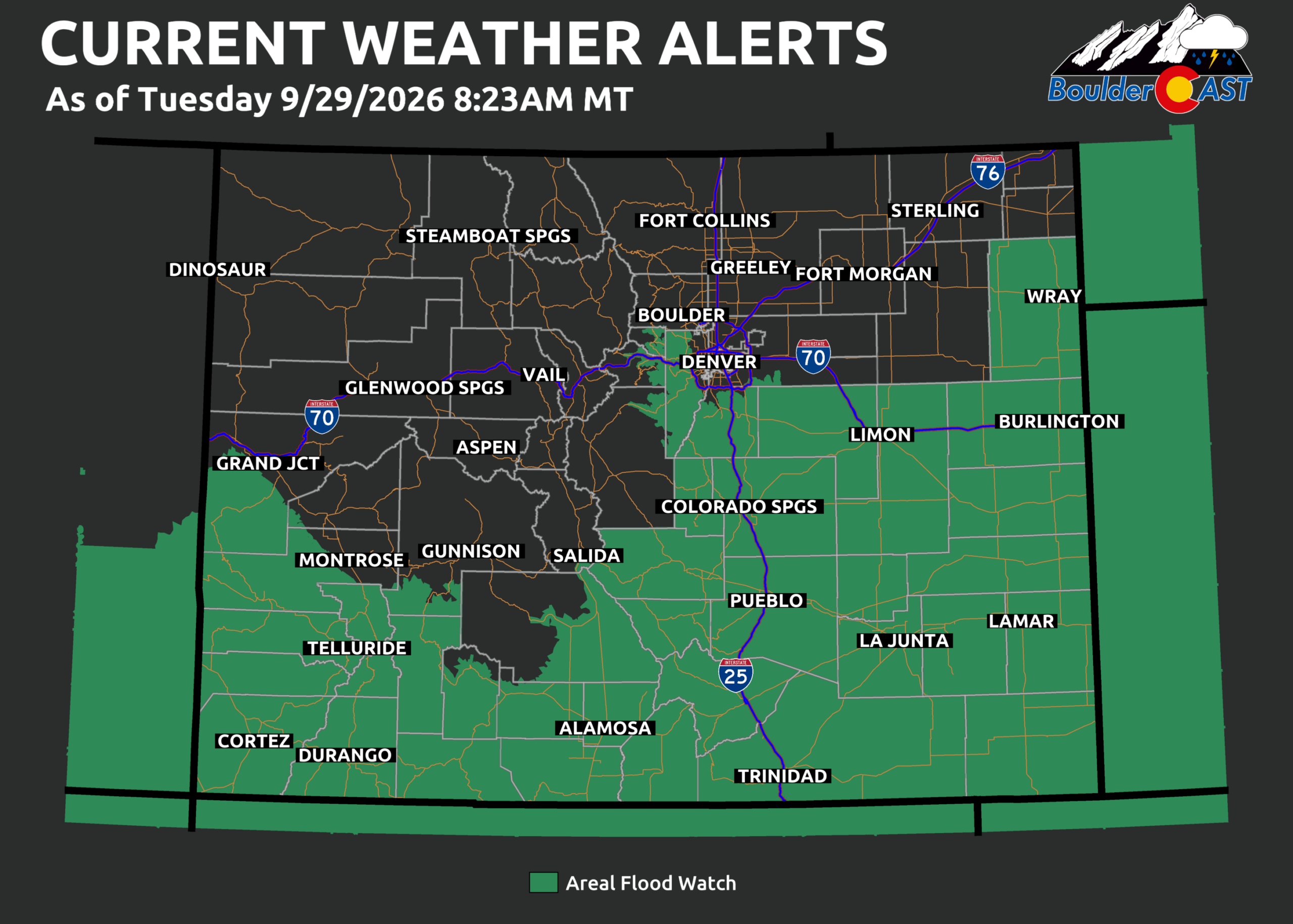
Given the nagging uncertainty and recent model trends going down, our team is leaning toward the lower-end outcomes, where the storm tracks further to the southeast and limits the rainfall around Denver and especially Boulder.
- Most of the Boulder-Denver area: Some light to perhaps moderate rain Wednesday into Wednesday night. Not a significant event at all.
- Northern tier (Longmont → Loveland → Fort Collins): May see very little or even no precipitation.
- Southern and southeastern suburbs: Best chance for 0.5″+, but this is far from guaranteed if not unlikely.
Potential Flood Risk
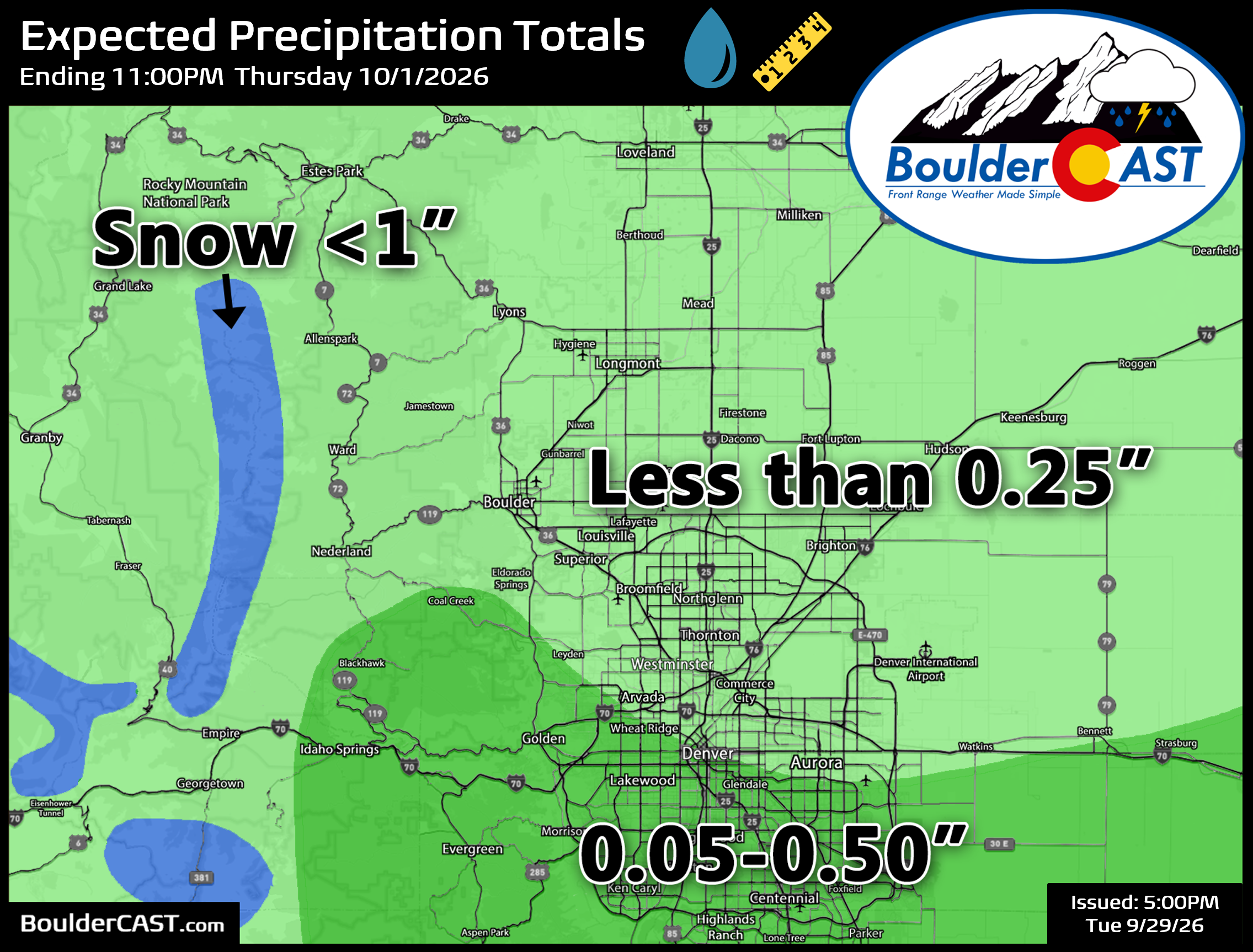
The greatest flood risk arrives Wednesday afternoon through Wednesday night, but will be focused in south-central Colorado from Pueblo south into New Mexico. We are particularly concerned about the Aspen Acres burn scar, which could see exceptional rain triggering flash floods, debris flows and even mudslides. If you live downstream of that area, be very cautious over the next 48 hours for flooding alerts!
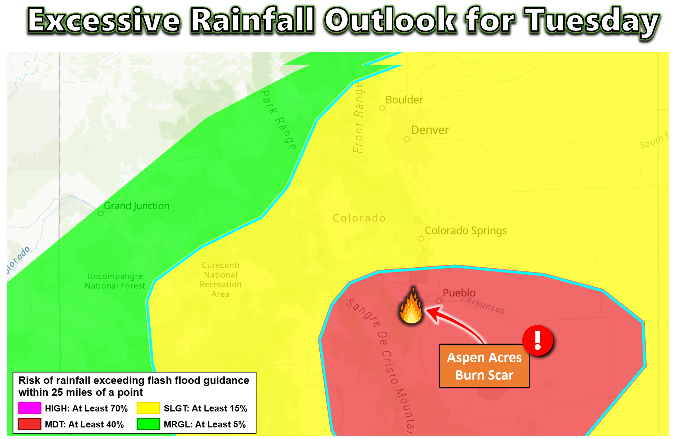
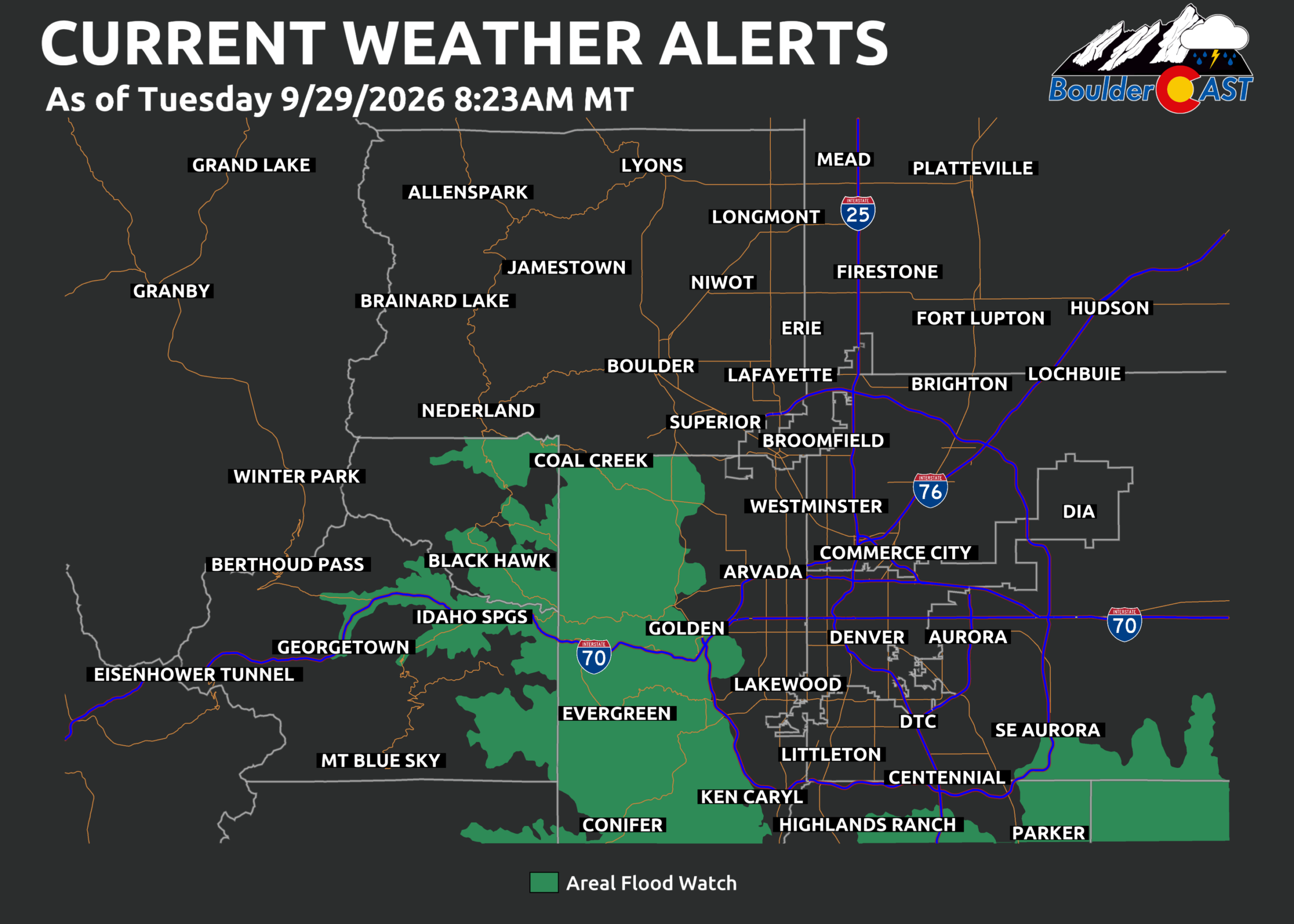
Elsewhere, Flood Watches cover most of southern Colorado and have expanded slightly northward into parts of the Denver Metro area.
Currently, only the Jefferson County Foothills and Palmer Divide are included. Based on current trends, we do not expect these watches to expand further north. Actual flood risk in these Watch areas is fairly low in our opinion, and these Watches may be cancelled.
Snow Levels & High-Elevation Impacts
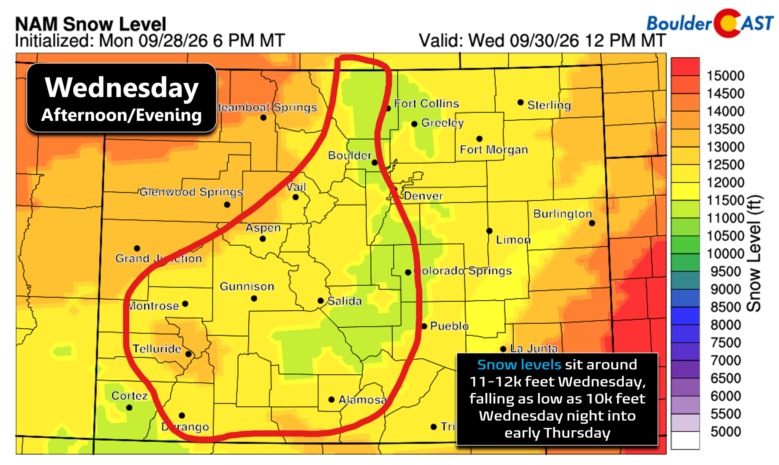
Snow levels will remain unseasonably high due to Polo’s warm tropical air:
- Wednesday daytime: ~12,000 ft
- Late Wednesday night: may dip to ~10,500 ft
Only the highest of Colorado’s peaks will see accumulation:
- Continental Divide near Boulder/Denver: one inch at most, favoring areas along and south of Indian Peaks.
- Southern Colorado high peaks (Sangres, San Juans): Up to a foot of wet, sloppy snow possible on 13ers and 14ers.
Travel impacts should be minimal overall — mainly rain or wet snow at pass level.
Storm Timeline
- Tuesday: Cool, mostly cloudy, a few spotty light showers. Highs in the upper 60s to 70°.
- Tuesday Night: Overcast and dry.
- Wednesday:
- North of I‑70: Isolated showers or sprinkles in the afternoon/evening, cloudy. Highs mid 60s
- South suburbs: A better chance of late-day showers but still not really steady or widespread rain. Highs in the lower 60s.
- Wednesday Night: Continued slight rain chances, mainly south/east of Denver.
- Thursday: Possibly a few morning clouds, then heaps of sunshine. Highs upper 60s to near 70°.
- Friday: Gorgeous, sunny and warmer. Highs approaching 80°.
Bottom Line
Colorado is entering a rare, highly complex storm setup driven by the merger of a Pacific upper-low and the remnants of Hurricane Polo — a combination that will inject deep tropical moisture into an already dynamic system. While confidence is high that southern Colorado will see significant rainfall and (very) high-elevation snow, the exact placement of the surface low and the tropical moisture plume remains a critical wildcard for the Denver–Boulder corridor. The Metro sits on the razor’s edge between a major soaking and a more disappointing, cloud-dominated event. Our forecast leans towards the latter.
Regardless of the final track, Wednesday will be the peak of impacts, with flooding concerns in southern Colorado and limited winter weather confined to the highest peaks. Sunshine and calmer weather will return by midday Thursday, setting up a beautiful Friday and weekend ahead with summerlike temperatures. Enjoy!
Spread the word, share our crazy Colorado weather:
Go Premium, get all the perks.
Daily Forecast Updates
Get our daily forecast discussion every morning delivered to your inbox.
All Our Model Data
Access to all our Colorado-centric high-resolution weather model graphics. Seriously — every one!
Ski & Hiking Forecasts
6-day forecasts for all the Colorado ski resorts, plus more than 120 hiking trails, including every 14er.
Smoke Forecasts
Wildfire smoke concentration predictions up to 72 hours into the future.
Exclusive Content
Weekend outlooks every Thursday, bonus storm updates, historical data and much more!
No Advertisements
Enjoy ad-free viewing on the entire site.












Leave a Reply
You must be logged in to post a comment.