


A complicated weather pattern is taking shape across Colorado this week, with a deep low pressure system, a surge of tropical moisture, and the remnants of Hurricane Polo all getting tangled up together. For Boulder, Denver and the Front Range, that combination creates some unusually large forecast uncertainties — particularly when it comes to how much rain falls and just how chilly things get by midweek. Meanwhile, southern Colorado is in store for a much bigger soaking, with some impressive rainfall totals showing up in the guidance alongside high peak snowfall. We break down what we know now, what remains uncertain, and when we can finally expect this week’s definitively gloomy weather to break and sunshine to return.
This week’s highlights include:
- 🌦️ Active weather week ahead: A deep, closed low pressure will develop over the Southwest US and track east into Colorado around midweek, interacting with the juicy remnants of Hurricane Polo.
- 🌀 Polo adds major uncertainty: How the tropical remnants phase with the upper-level low will largely determine rainfall amounts, temperatures, and the eventual storm track across Colorado.
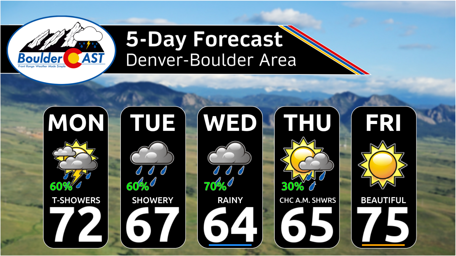
- 🌡️ Big cooldown midweek: Monday should be mild in the lower 70s, but temperatures will fall into the 60s Tuesday–Thursday, some 10–15°F below normal.
- 💧 Anomalous moisture surges north: Precipitable water will exceed one inch along the Front Range, bringing unusually deep tropical moisture for late September.
- 🌧️ Rainfall forecast remains messy: Boulder and Denver could receive anywhere from a few tenths of an inch to around 2 inches, with the heaviest precipitation favored south and east of the Metro area.
- ⛈️ Southern Colorado faces the biggest rain threat: Parts of central and southern Colorado could see 1–3+ inches, with localized higher amounts possible and an elevated flooding risk.
- ❄️ Some high-elevation snow: Snow levels will remain unusually high due to the tropical air infusion, but the highest peaks above ~12,000 feet could pick up several inches of wet snow.
- ☀️ Much nicer late week: The system should weaken and depart by Thursday, bringing drier weather and warming temperatures. Friday looks particularly pleasant, with 70s and sunshine, followed by generally warm weather into the weekend.
DISCLAIMER: This weekly outlook forecast is created Monday morning and covers the entire upcoming week. Accuracy will decrease as the week progresses as this post is NOT updated. To receive daily updated forecasts from our team, among many other perks, subscribe to BoulderCAST Premium.

Go Premium, get all the perks.
Daily Forecast Updates
Get our daily forecast discussion every morning delivered to your inbox.
All Our Model Data
Access to all our Colorado-centric high-resolution weather model graphics. Seriously — every one!
Ski & Hiking Forecasts
6-day forecasts for all the Colorado ski resorts, plus more than 120 hiking trails, including every 14er.
Smoke Forecasts
Wildfire smoke concentration predictions up to 72 hours into the future.
Exclusive Content
Weekend outlooks every Thursday, bonus storm updates, historical data and much more!
No Advertisements
Enjoy ad-free viewing on the entire site.
A Complicated, Moist, and Potentially Very Wet Week Ahead
If you’ve been following along with us of late, you already know the setup: a deep area of low pressure is developing over the Southwest and will slowly trek eastward into Colorado and New Mexico around midweek before weakening across the Central Plains. What makes this forecast particularly tricky is the interaction between that cutoff low and the remnants of Hurricane Polo.
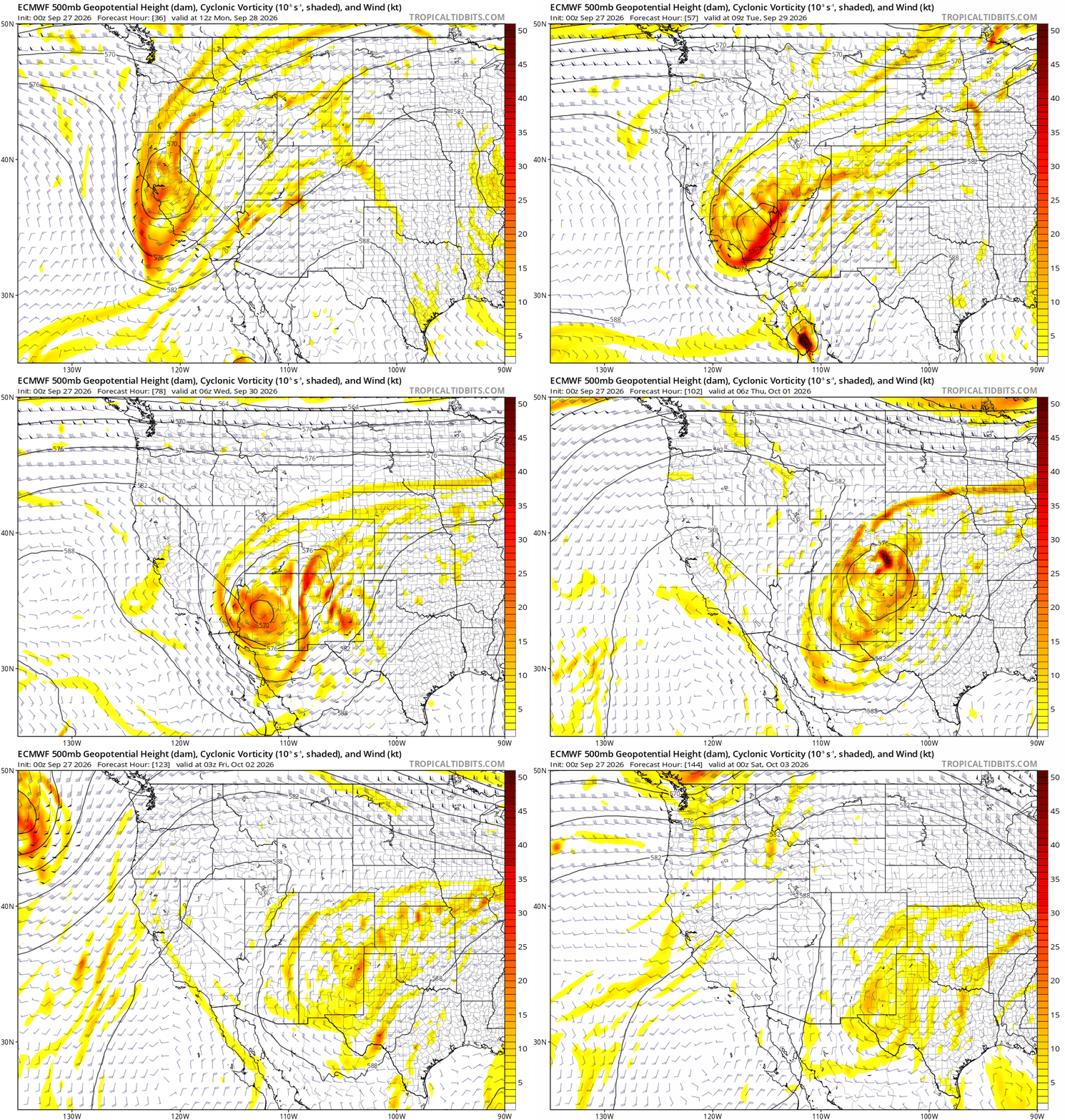
Euro model 500mb vorticity and height forecast animation through the week showing the phasing of the cut-off low and Polo’s remnants directly over Colorado
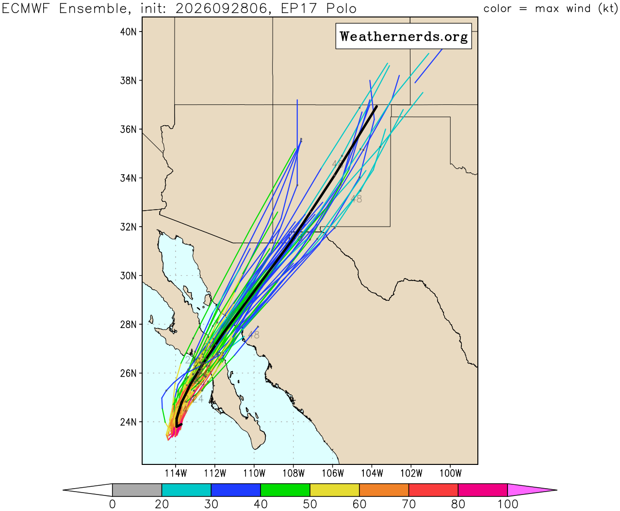
The National Hurricane Center (NHC) shows that Polo will make landfall over southern portions of Baja California during the day Monday before passing through the Mexican state of Sonora as a weakened Tropical Storm or Depression.
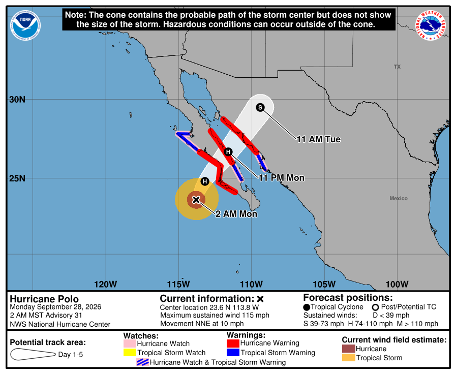
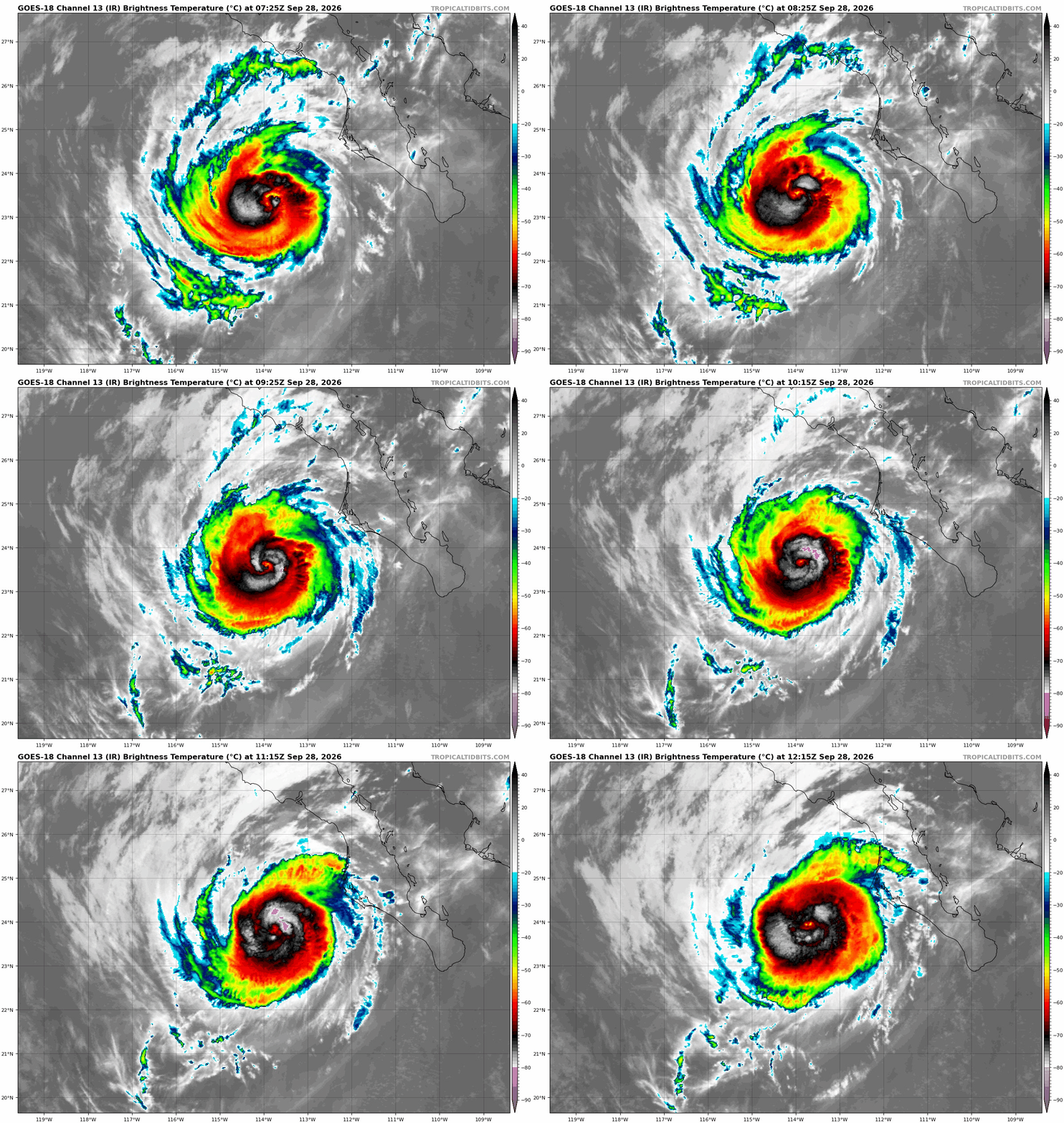
GOES-West infrared satellite animation of Cat 3 Hurricane Polo Monday morning as it approaches Baja California
Over the last several days, there have been some model solutions, namely the outlier Canadian, which has tried to keep Polo south of Baja and not bring it up into the the Desert Southwest at all, contrary to other guidance. Those solutions were definitely wrong at this point, but this is one example of the challenge models have had with how Polo may interact with the aforementioned trough of low pressure. That interaction will ultimately have a major influence on how much rain we see along the Front Range — and how chilly temperatures get.
A Wide Range of Possible Outcomes
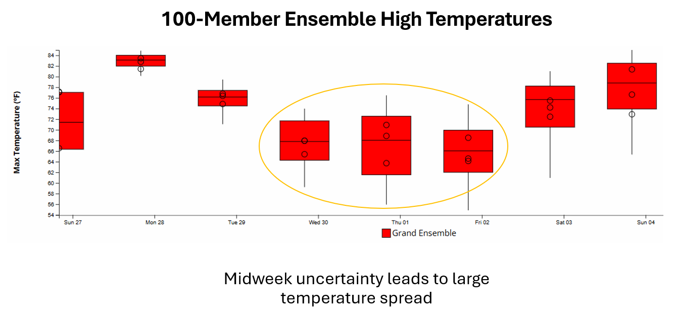
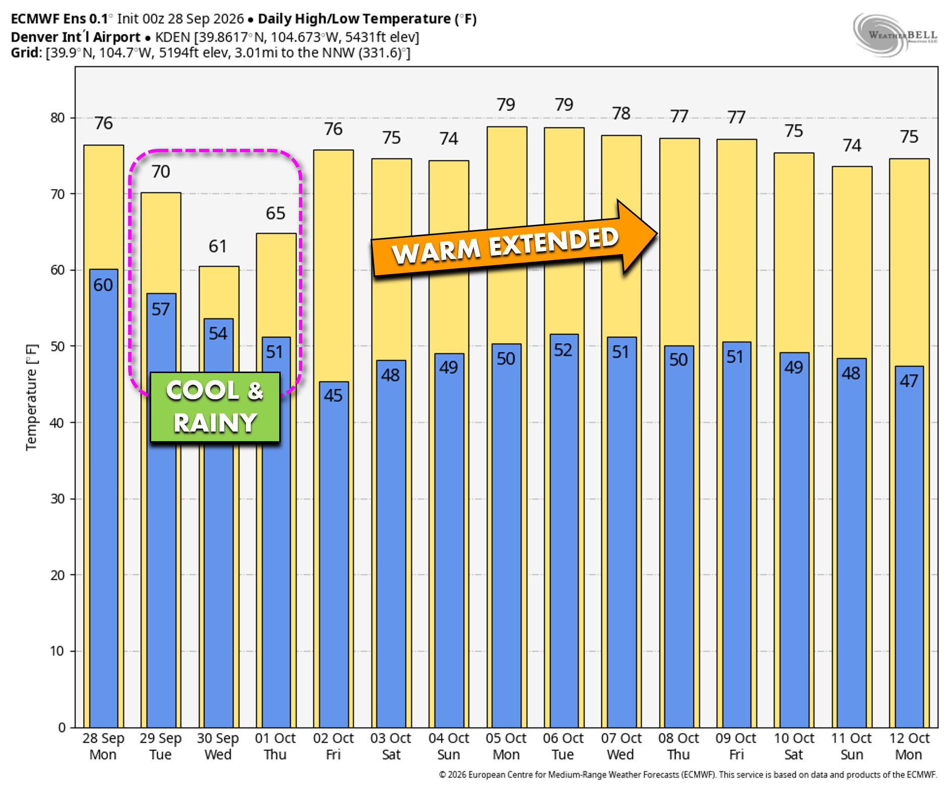
The uncertainty is readily apparent in the ensemble guidance. Monday is a relatively straightforward forecast, with high temperatures likely reaching the low to middle 70s. Confidence drops substantially Tuesday through Thursday (circled below), however, as the eventual track and evolution of the low become more important.
Ensemble high temperatures span roughly the middle 50s to lower 70s during the middle of the week, with the median hovering in the mid to upper 60s. Regardless of the exact outcome, a noticeable cooldown is increasingly likely, with temperatures potentially running 10 to 15 degrees below seasonal averages.
Rainfall projections are similarly messy. The highest precipitation potential for the Front Range currently appears to be Tuesday and Wednesday, though some solutions keep the wet weather going into Thursday. Ensemble rainfall totals for Denver range from just a few hundredths of an inch to nearly 3 inches, with many members clustering between roughly 0.25 and 1 inch.
The reason for that enormous spread comes down to the interaction with Polo. Some solutions produce a stronger Fujiwara-type interaction between Polo and the now remnants of Hurricane Odalys, allowing tropical moisture to wrap farther north and west. That would favor stronger upslope flow, cooler temperatures, and considerably more rainfall across the Front Range. Other solutions keep the systems less phased or farther south, resulting in more downslope flow, less precipitation, and milder temperatures.
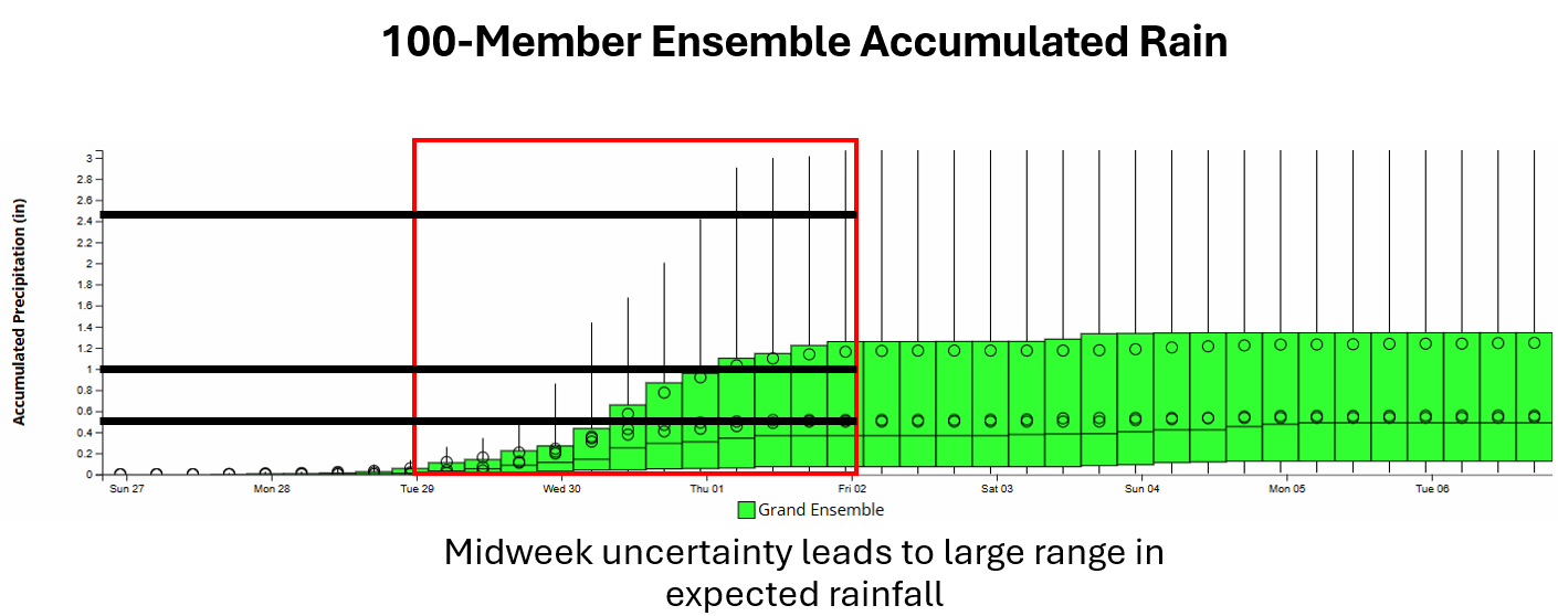
Rather than focusing too heavily on any one ensemble system or run, the important takeaway is the unusually large range of plausible outcomes.
A Surge of Tropical Moisture
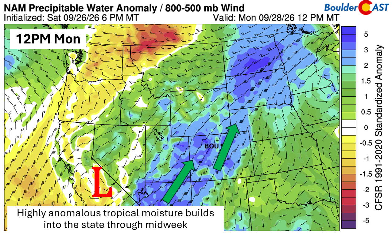
Regardless of the exact track, one aspect of the forecast is becoming increasingly clear: very deep, anomalous moisture will surge northward into Colorado this week.
Precipitable water values could exceed 1 inch along the Front Range as early as Monday (tied to Hurricane Odalys’ remnants) — exceptionally high for late September. Scattered showers and a few thunderstorms are possible Monday afternoon and evening, with the highest precipitation chances initially focused across the High Country.
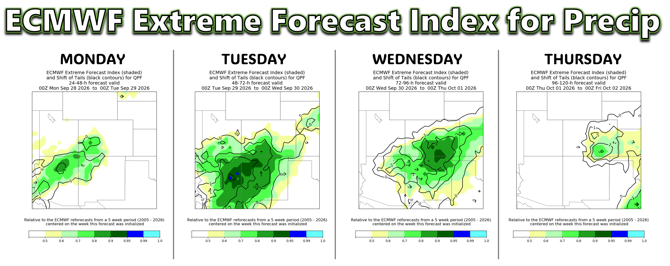
In fact, a highly anomalous pattern discussed earlier is fueling some signals in the guidance for anomalous rainfall across the state this week. Shown below are 4 images from the ECMWF ensemble Extreme Forecast Index for Monday through Thursday. Contours in the dark green or blue are indicative of anomalous rainfall potential. That signal is pretty clear for the southern and southwest parts of Colorado well into Thursday. There are even a few ensemble members that indicate an extreme precipitation event, denoted by the contour values in black of 2 or greater. These contours denote the tail-end of the distribution discussed earlier. Note that a few 1 to 2 contour values are present Wed-Thu in Denver, but the darker green shading is still south, indicating a higher degree of model spread in the Metro area compared to southern and southeast Colorado.
Southern Colorado Deluge…and a Little Snow?
The potential for heavy rain is much more straightforward across southern and southwestern Colorado than it is here along the Front Range.
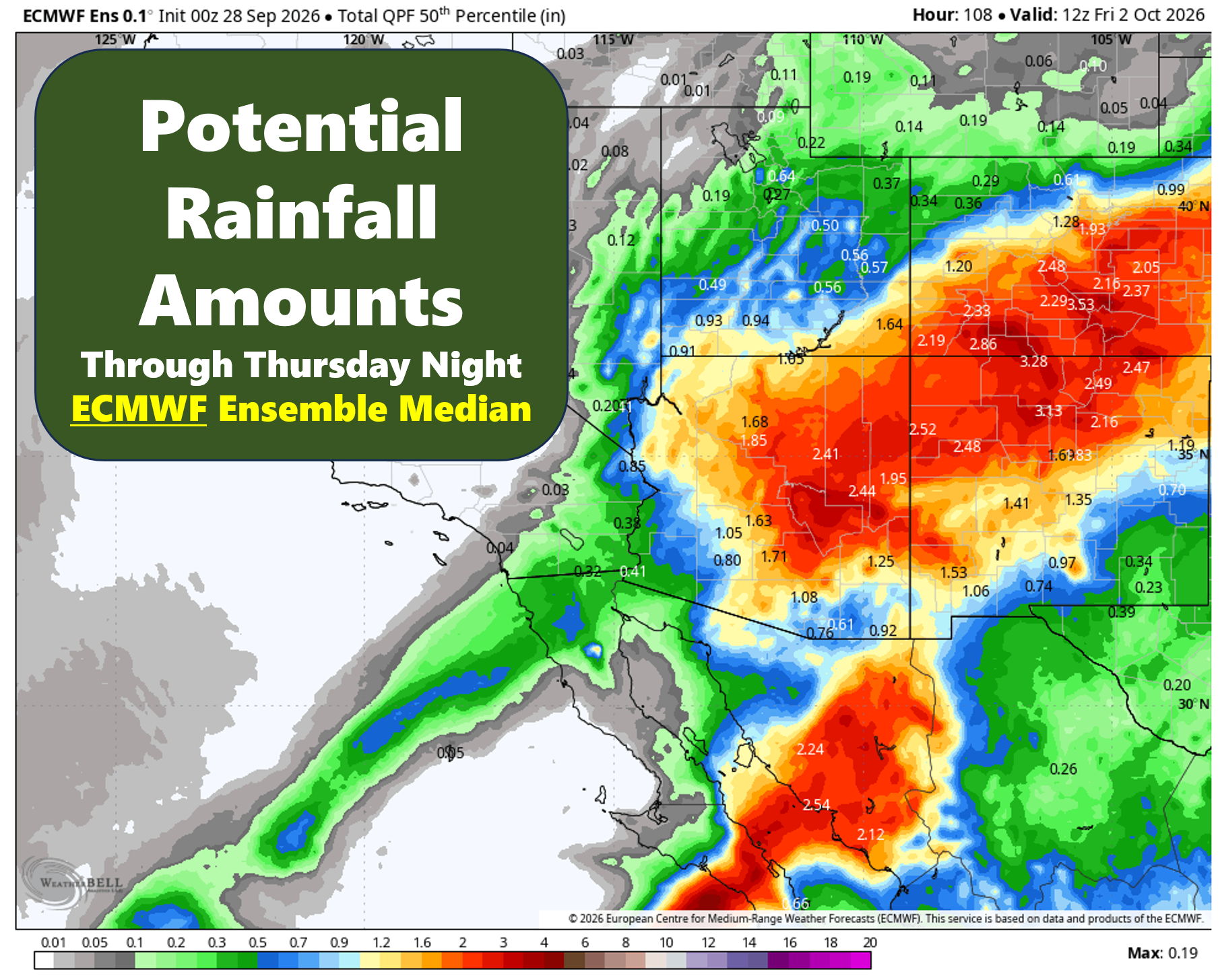
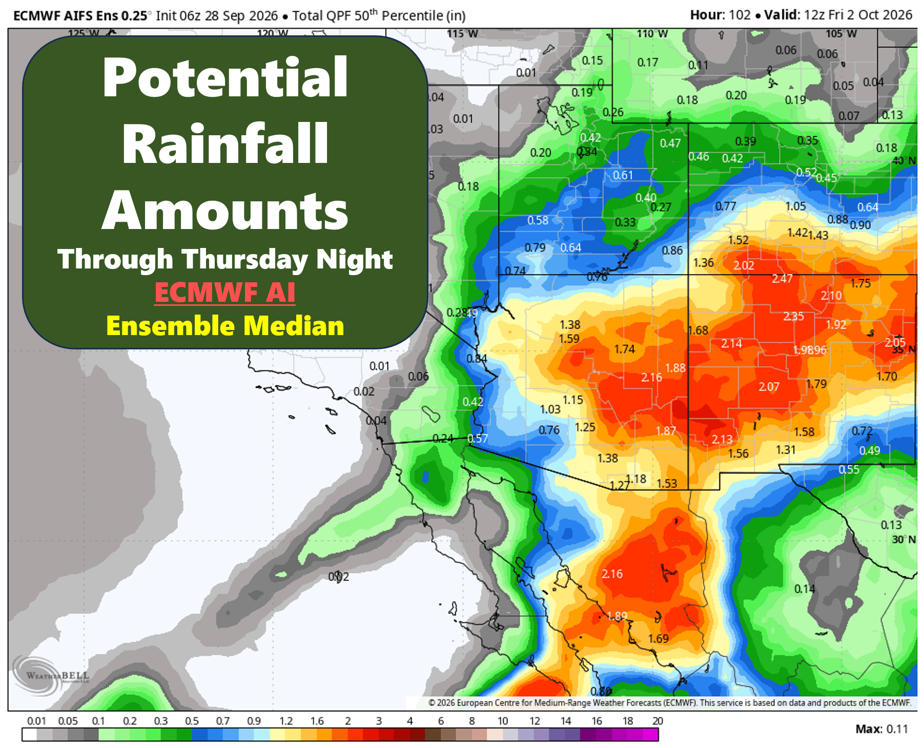
Recent ECMWF ensemble guidance shows a broad swath of 1 to nearly 3 inches of precipitation across central and southern Colorado, with the largest amounts in the southwest mountains and near the New Mexico border. This particular run is on the wetter side of the guidance, however, so those numbers should not be interpreted as a precise forecast.
 The GEFS shows a similar signal for central and southern Colorado, generally in the 1 to 2.5-inch range, with locally higher totals near northern New Mexico. Farther north, however, the precipitation gradient becomes quite sharp, with some solutions producing only a few tenths of an inch across the Front Range.
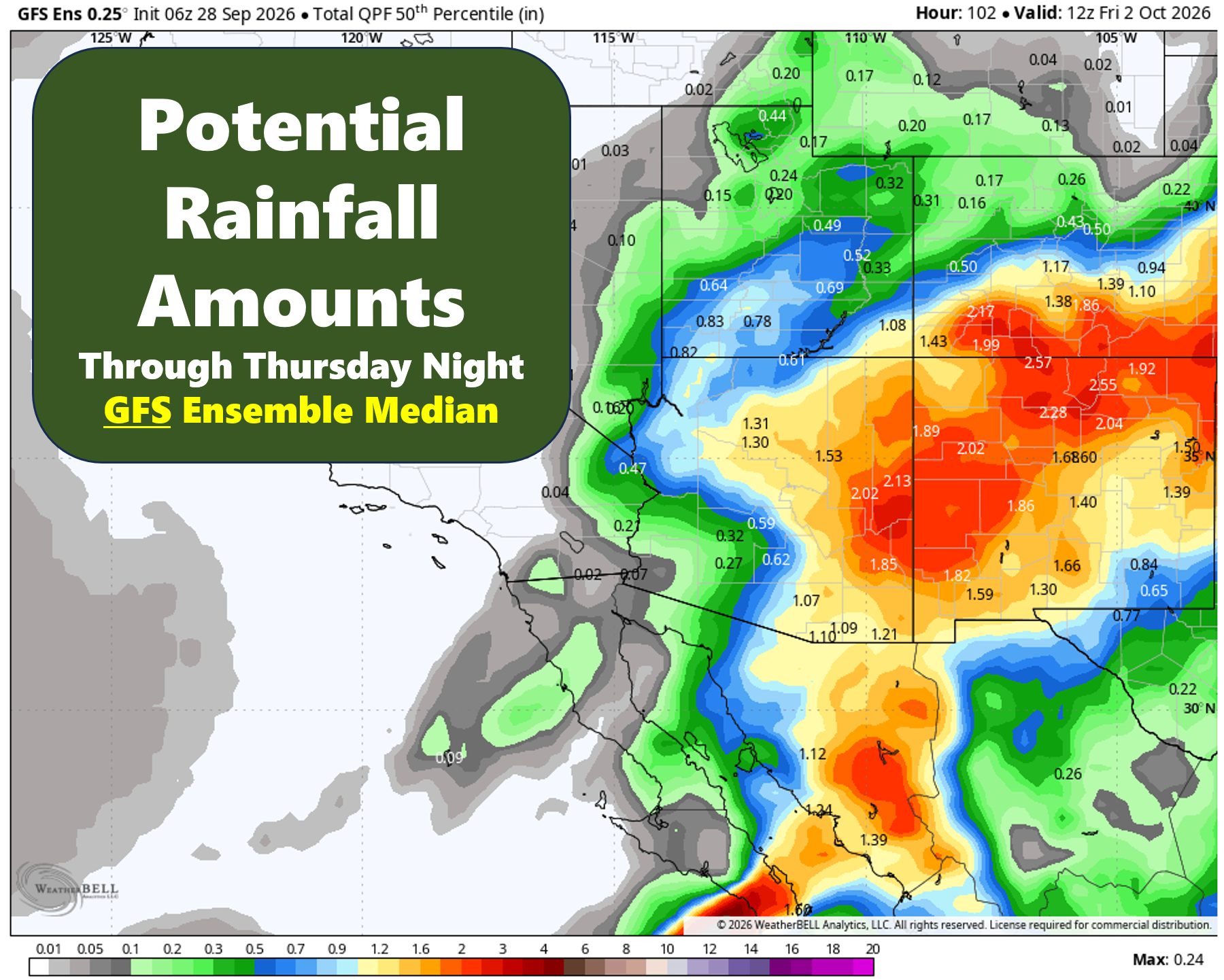
That sharp gradient is important. Small changes in the position of the low could mean the difference between a soaking rain and a relatively minor event for Boulder and Denver.
Ultimately, a lot will depend on how close the slow-moving surface low gets to the Front Range Wednesday and how far north and west the tropical moisture associated with Polo can wrap. The closer the low gets — and the longer it remains nearby — the greater the potential for persistent upslope flow and moderate to heavy rainfall rates.
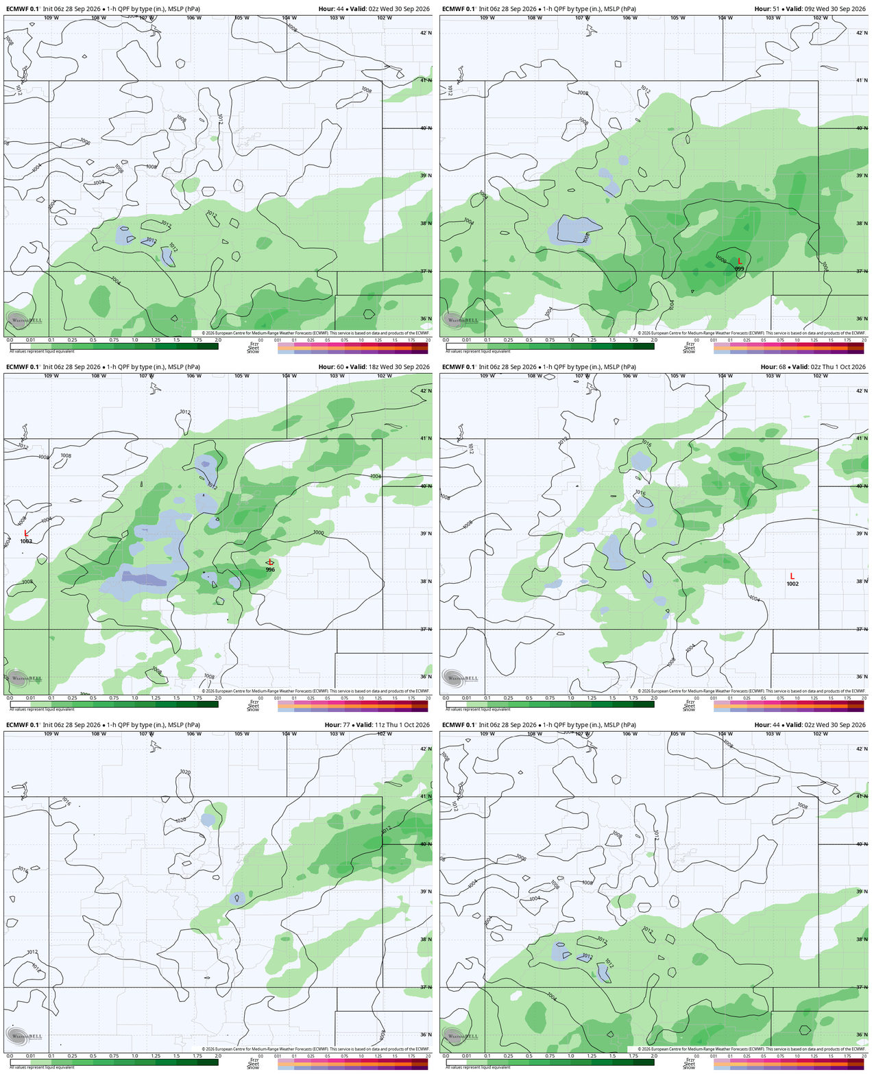
Precipitation and sea-level pressure forecast animation from the Euro model Tuesday night through Thursday. This depicts the wettest possible scenario for the Denver area.
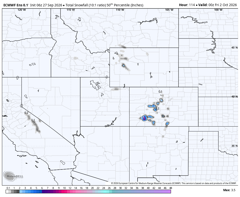
Even a few snowflakes could fall at the highest elevations by midweek, but don’t expect a major, early-season snowstorm in the Mountains. The character of this system is strongly tropical, with warm and exceptionally moist air keeping snow levels unusually high for late September and early October.
Ensemble guidance does indicate snow above roughly 12,000 feet, and some of the highest peaks in the San Juans and Sangres could pick up several inches of wet snow. For all the Mountain passes and communities, this will be a rain event.
Flooding Potential
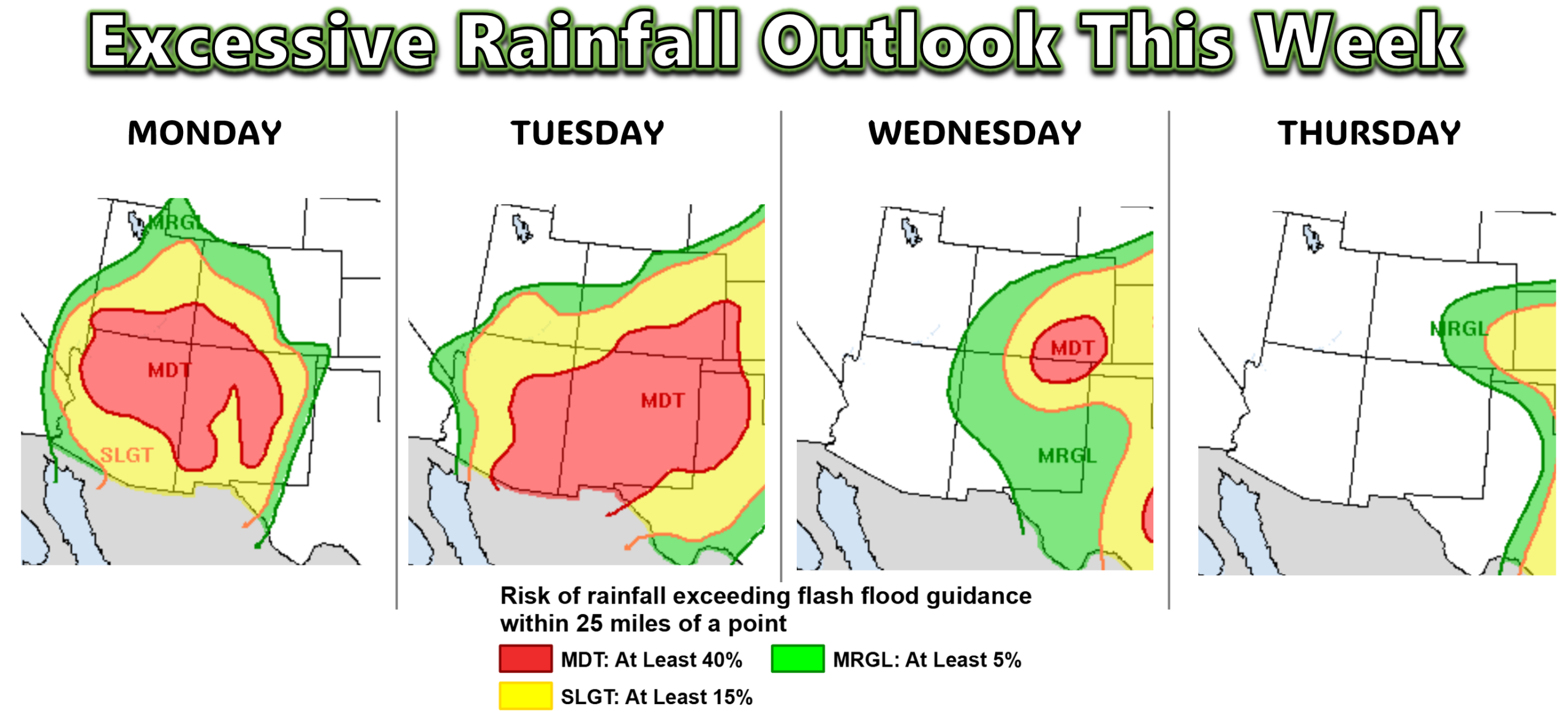
The potential for heavy rainfall and flooding is the biggest concern with this setup. The Weather Prediction Center currently has a Level 3 Moderate Risk of excessive rainfall across southern Colorado Monday through Wednesday, while portions of the Denver Metro area — primarily southeast of the city — are under a Level 2 Slight Risk Tuesday and Wednesday.
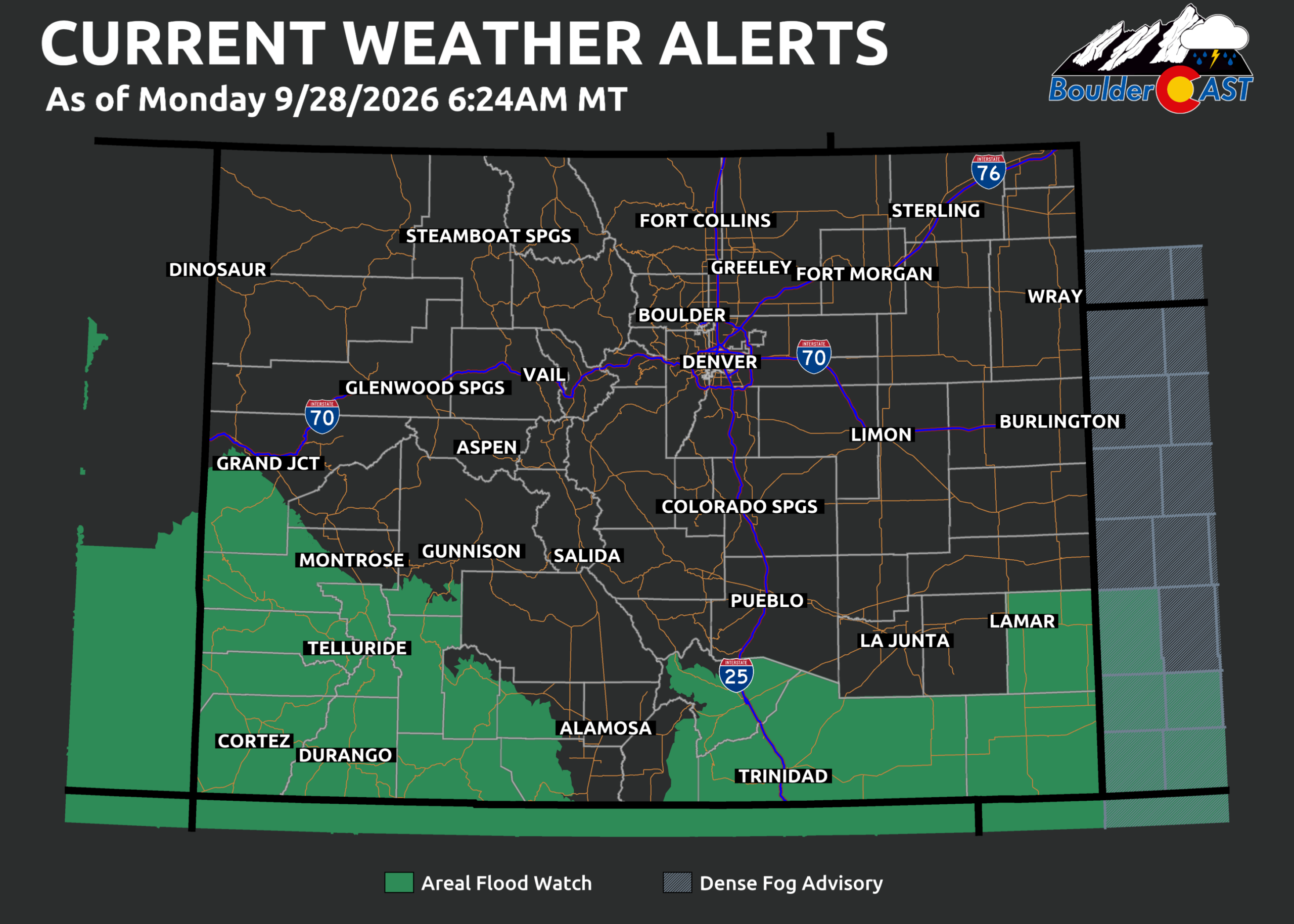
Flood Watches are already in effect across much of the Four Corners region, including all of New Mexico and basically all of Arizona.
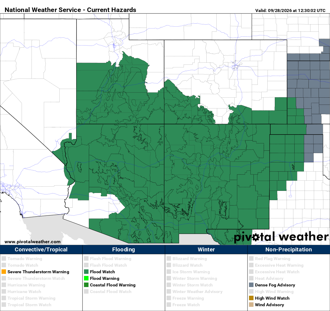
As of Monday morning, Flood Watches for the week currently remain south of Pueblo in Colorado along the New Mexican border. However, as forecast confidence improves over the next 24 to 36 hours, those watches could expand northward into additional portions of Colorado and potentially the Denver Metro area.
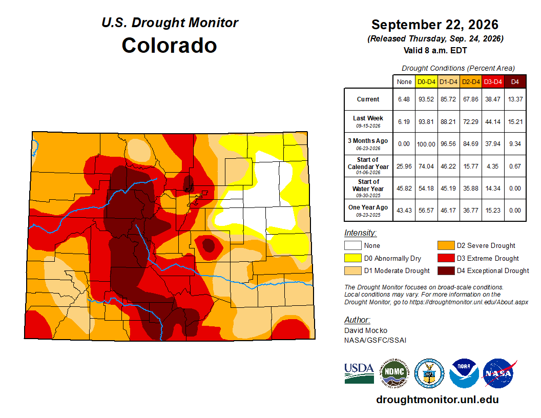
The irony here is that much of Colorado is currently experiencing significant drought, so a widespread soaking rain will be very beneficial. Unfortunately, rainfall this heavy can also create flash flooding and other hydrologic problems in these arid regions, particularly where soils are unable to absorb the rainfall quickly enough, such as nascent burn scars, or in areas the areas that have seen recent heavy rains across southern Colorado.
The Week Ahead in a Nutshell
- Mild Monday with scattered storms: Temperatures reach near 70° with showers and a few thunderstorms.
- A wet setup develops: Very deep tropical moisture spreads northward, with widespread rainfall developing across much of Colorado Monday through Wednesday.
- Front Range rainfall remains highly uncertain: Boulder and Denver could see anything from a few tenths to an inch or more, with the highest potential generally south and east of Denver. Some solutions keep the heaviest rain south of the Metro area altogether. Our best guess forecast at this point is for 0.25 to 2.0″ of rain, highest southeast of Denver.
- A chilly midweek: Temperatures will drop into the 60s, with some solutions producing highs in the 50s if Wednesday turns out especially wet.
A Late-Week Break
Fortunately, the forecast becomes much easier later in the week.
The low should weaken and shift out of southeastern Colorado by Friday, allowing drier air to return to the Front Range beginning Thursday afternoon. Temperatures will rebound, with highs likely reaching the 70s Friday under plentiful sunshine. At this point, Friday unquestionably looks like the nicest day of the week.
That pleasant weather may continue into the weekend as a blocking ridge builds over the West. The ridge is set to persist through the first week or two of October, favoring generally warm and dry conditions across much of the western United States.
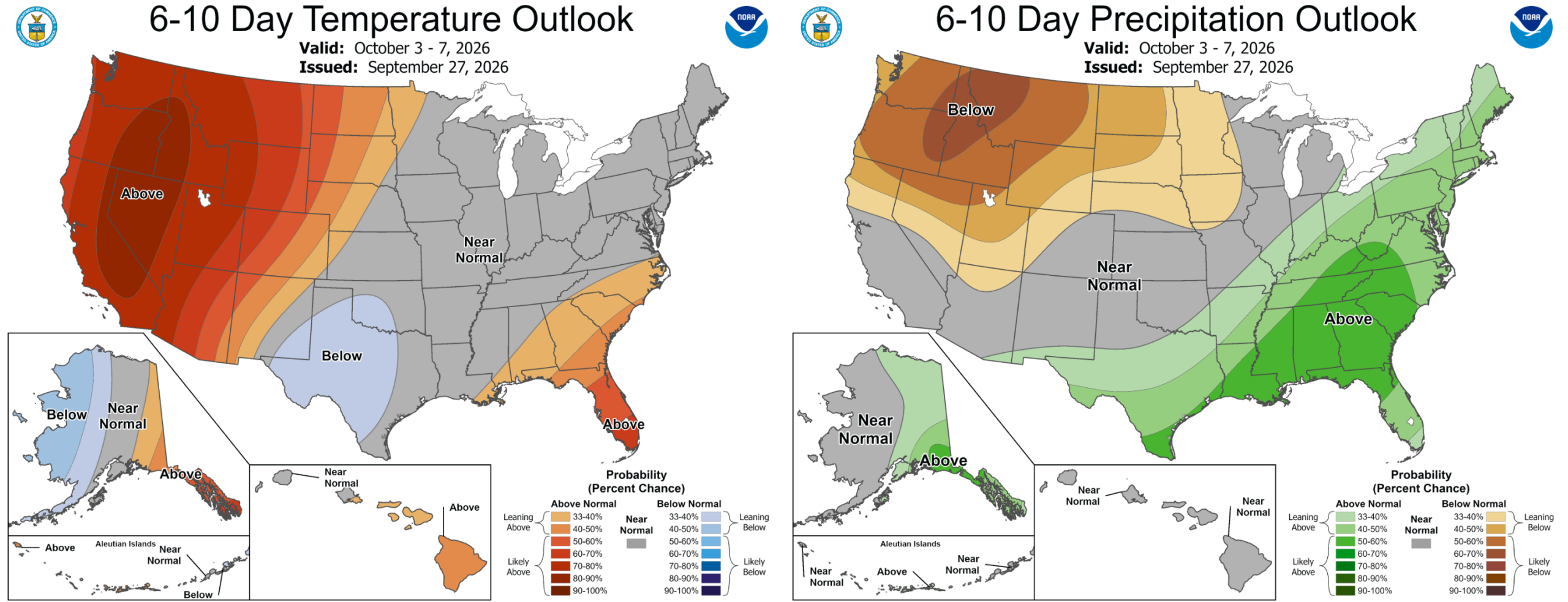
Colorado will sit along the eastern periphery of that ridge, meaning we should remain relatively mild to warm overall, but occasional backdoor cold fronts could sneak southward from the central United States. So while several days could approach 80°, brief cooldowns will still be in the cards. On the contrary, areas in the Pacific Northwest and West Coast will experience a prolonged, autumn heatwave through early October.
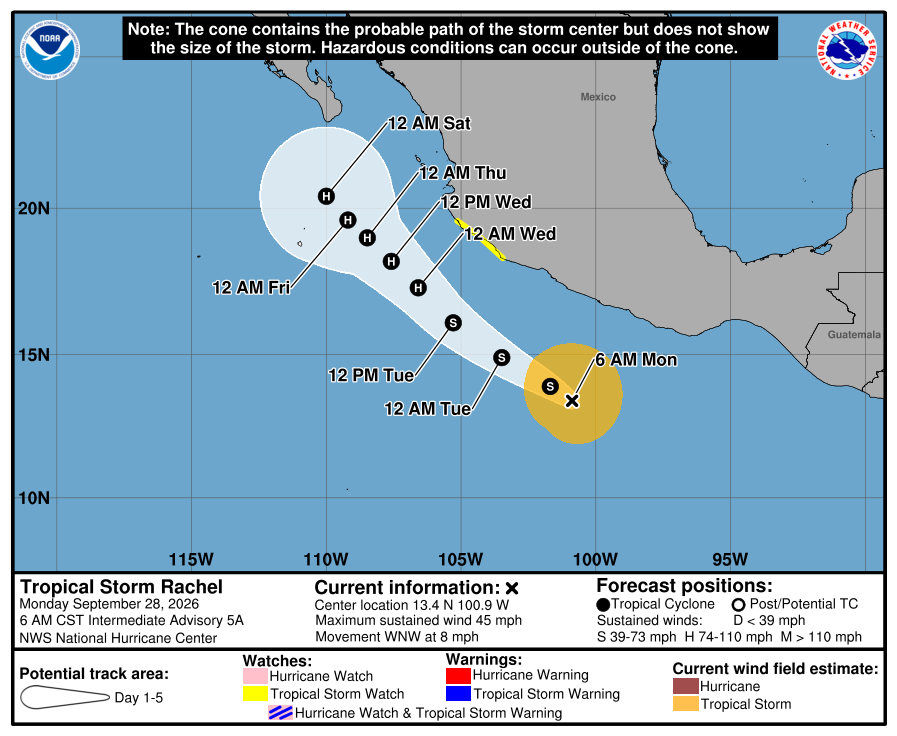
Meanwhile, the eastern Pacific remains active. Tropical Storm Rachel is expected to become a hurricane and approach Baja California this weekend, following closely behind Polo. Its eventual evolution bears watching, although current guidance keeps the risk of a direct impact to Colorado low as Rachel is likely to track away from land.
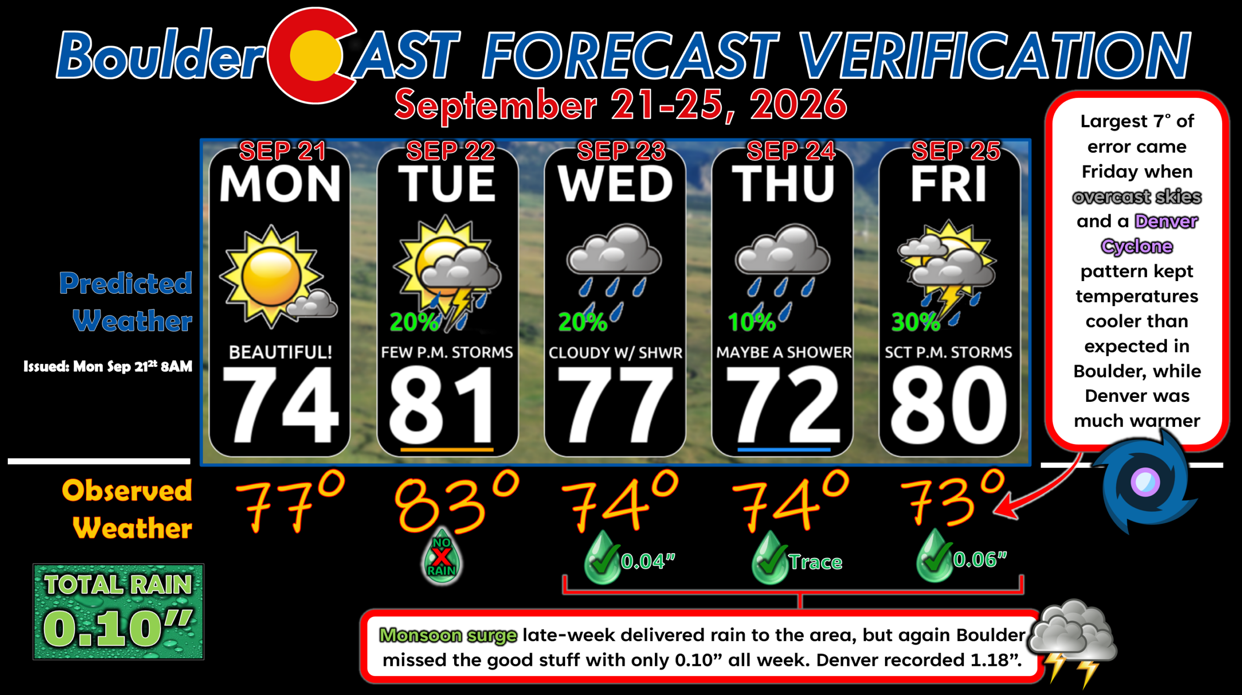
Forecast Verification: September 21-25 2026 (Last Week)
- 3 days of rain = 0.10″ Boulder, 1.18″ Denver
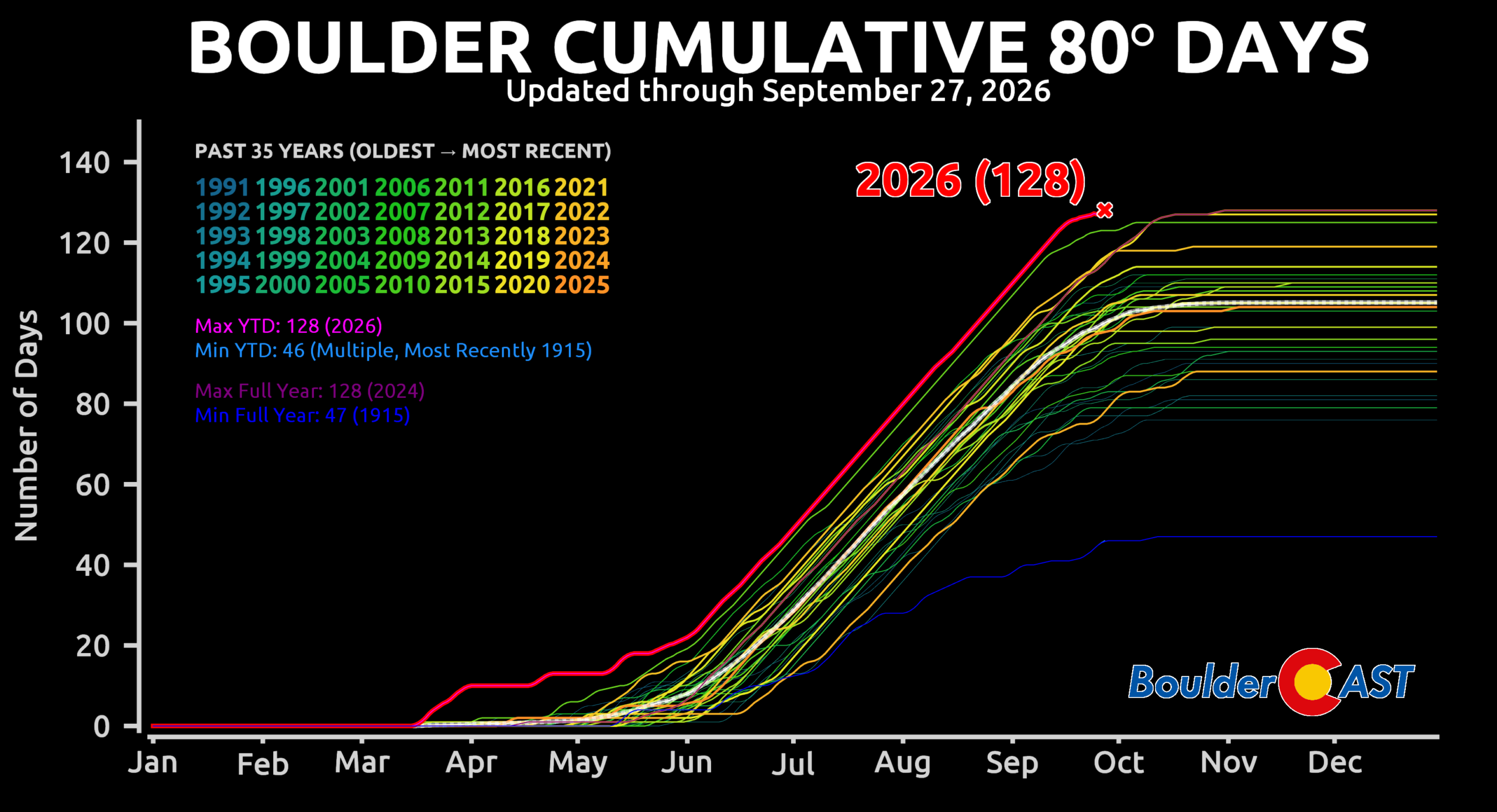
- One more 80° day — Boulder sits at a count of 128 for the year, tied for the all-time calendar year record with 2024
- Largest temperature error was 7° on Friday when overcast skies and a Denver Cyclone pattern kept temperatures cooler than expected in Boulder (low 70s) while Denver was warmer (near 80°)
- Otherwise, temperature forecasts were within 0 to 3° every other day.
DISCLAIMER: This weekly outlook forecast is created Monday morning and covers the entire upcoming week. Accuracy will decrease as the week progresses as this post is NOT updated. To receive daily updated forecasts from our team, among many other perks, subscribe to BoulderCAST Premium.
Go Premium, get all the perks.
Daily Forecast Updates
Get our daily forecast discussion every morning delivered to your inbox.
All Our Model Data
Access to all our Colorado-centric high-resolution weather model graphics. Seriously — every one!
Ski & Hiking Forecasts
6-day forecasts for all the Colorado ski resorts, plus more than 120 hiking trails, including every 14er.
Smoke Forecasts
Wildfire smoke concentration predictions up to 72 hours into the future.
Exclusive Content
Weekend outlooks every Thursday, bonus storm updates, historical data and much more!
No Advertisements
Enjoy ad-free viewing on the entire site.
Enjoy our content? Give it a share!












Leave a Reply
You must be logged in to post a comment.