


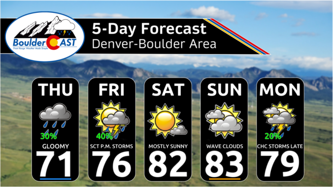
The pattern is gradually shifting across Colorado, with lingering moisture keeping Thursday cool and cloudy before drier, warmer weather settles in for the weekend. Beyond that, the forecast becomes much less certain as the first significant autumn trough approaches from the west and potentially interacts with the remnants of Hurricane Polo across the southern Rockies. There are several possible outcomes for early next week in the Front Range, ranging from a quick cooldown with some showers to a much wetter setup. We break down what the models are showing, what we’re confident in, and what remains uncertain.
What You Need to Know
- 🌧️ Wednesday Rain Recap: Most of the Denver Metro saw little or no rain, but 0.5–0.75″ fell near Standley Lake and Rocky Flats—welcome moisture for an area that has been exceptionally dry.
- 💦 Deep Moisture Persists: A remarkable plume of subtropical/monsoonal moisture remains over Colorado and New Mexico, with unusually high precipitable water for late September.
- 🌀 Hurricane Polo: Category 5 Hurricane Polo continues churning off the Mexican coast with 160 MPH sustained winds.
- ⛈️ Thursday Stays Gloomy: Extensive clouds will limit heating and instability, keeping Denver’s rain chances low during the day. Odds increase to around 30% this evening and overnight as upslope flow strengthens.
- 🌡️ Cool Thursday: Mostly cloudy skies will hold highs to the upper 60s and lower 70s across the lower elevations.
- 🌦️ Friday May Deliver: The monsoon plume shifts east, but one final shortwave could trigger a round of afternoon/evening thunderstorms—potentially everyone’s best rain chance of the week—before drying out.
- ☀️ Weekend Looks Beautiful: High pressure builds in for sunny, dry weather Saturday and Sunday, with temperatures warming into the 80s. Sunday will feature wave clouds.
- 👀 Next week is a Wild Card: A developing Pacific trough could interact with Hurricane Polo’s tropical remnants, potentially producing a significant rain event—but the 3–6″ “Perfect Storm” scenario for the Front Range is currently a major model outlier.

Go Premium, get all the perks.
Daily Forecast Updates
Get our daily forecast discussion every morning delivered to your inbox.
All Our Model Data
Access to all our Colorado-centric high-resolution weather model graphics. Seriously — every one!
Ski & Hiking Forecasts
6-day forecasts for all the Colorado ski resorts, plus more than 120 hiking trails, including every 14er.
Smoke Forecasts
Wildfire smoke concentration predictions up to 72 hours into the future.
Exclusive Content
Weekend outlooks every Thursday, bonus storm updates, historical data and much more!
No Advertisements
Enjoy ad-free viewing on the entire site.
Recap: Rain and Snow Across Colorado
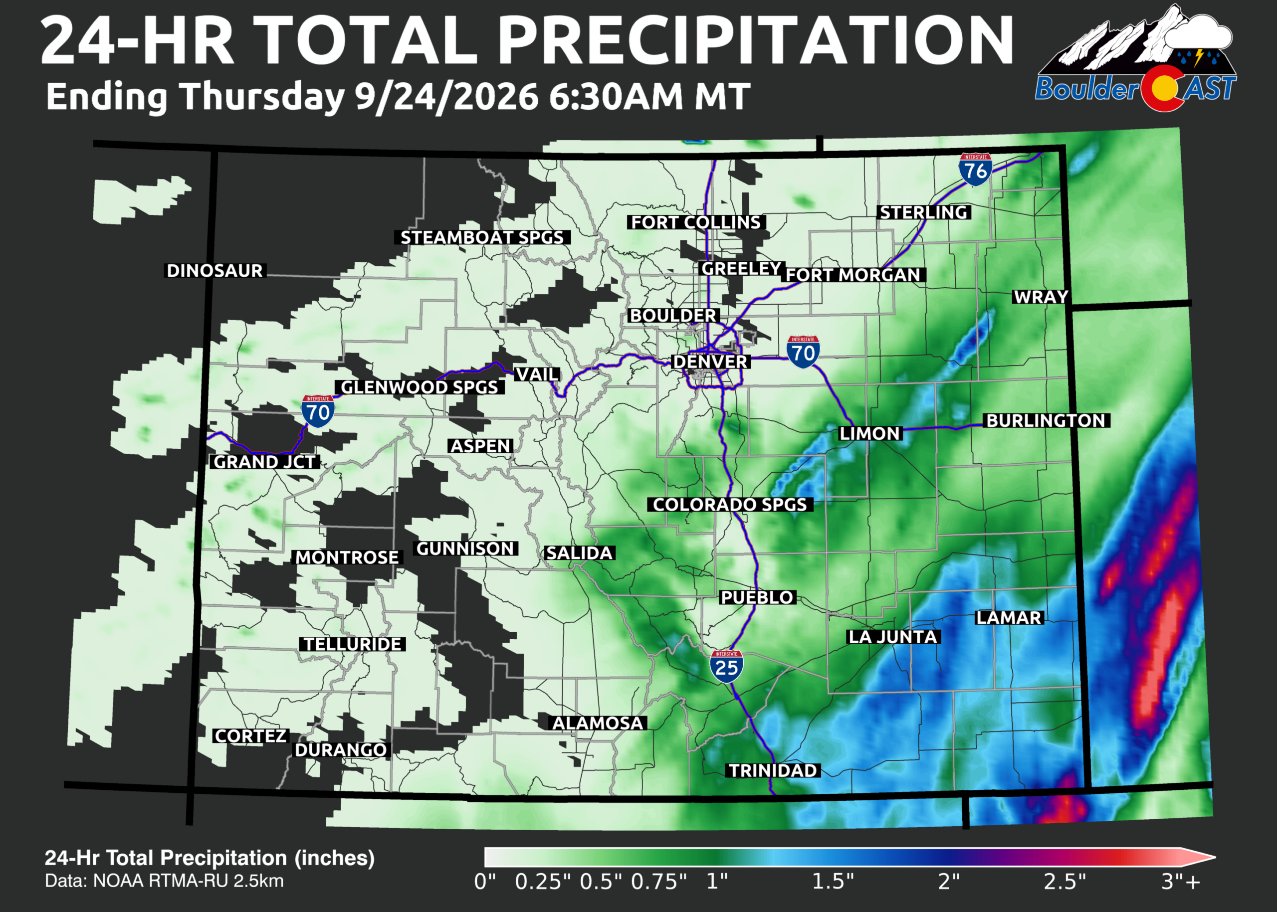
Portions of the Denver Metro area picked up a little rain Wednesday, with a few slow-moving showers bubbling up during the evening hours. Most locations received anywhere from nothing to around a tenth of an inch, but the Standley Lake/Rocky Flats area was the big winner, with 0.5 to 0.75 inches of much-needed rainfall. That’s especially welcome news given how exceptionally dry this part of the Metro area has been over the last several months.
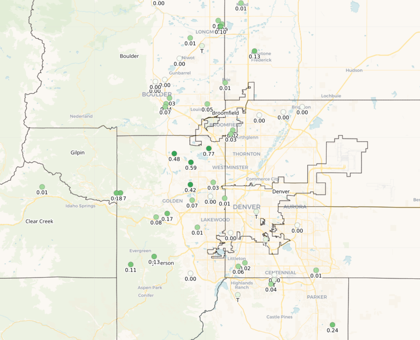
24-hour rainfall totals ending 7AM Thursday. Not much overall.
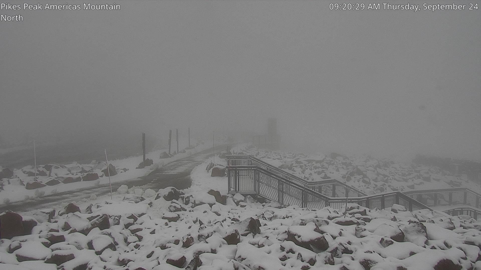
The highest peaks across the central and southern tier of the state, including Pikes Peak, saw some wet snow over the last 24 hours as expected.
GOES-East water vapor imagery Thursday morning continues to show an impressive plume of deep subtropical moisture draped across New Mexico and Colorado. The sheer extent and richness of this moisture this late in September is remarkable. For perspective, precipitable water values across the region remain extraordinarily high for the time of year. Meanwhile, Hurricane Polo is visible just off the coast of Mexico and remains a formidable Category 5 hurricane, packing sustained winds near 160 MPH.
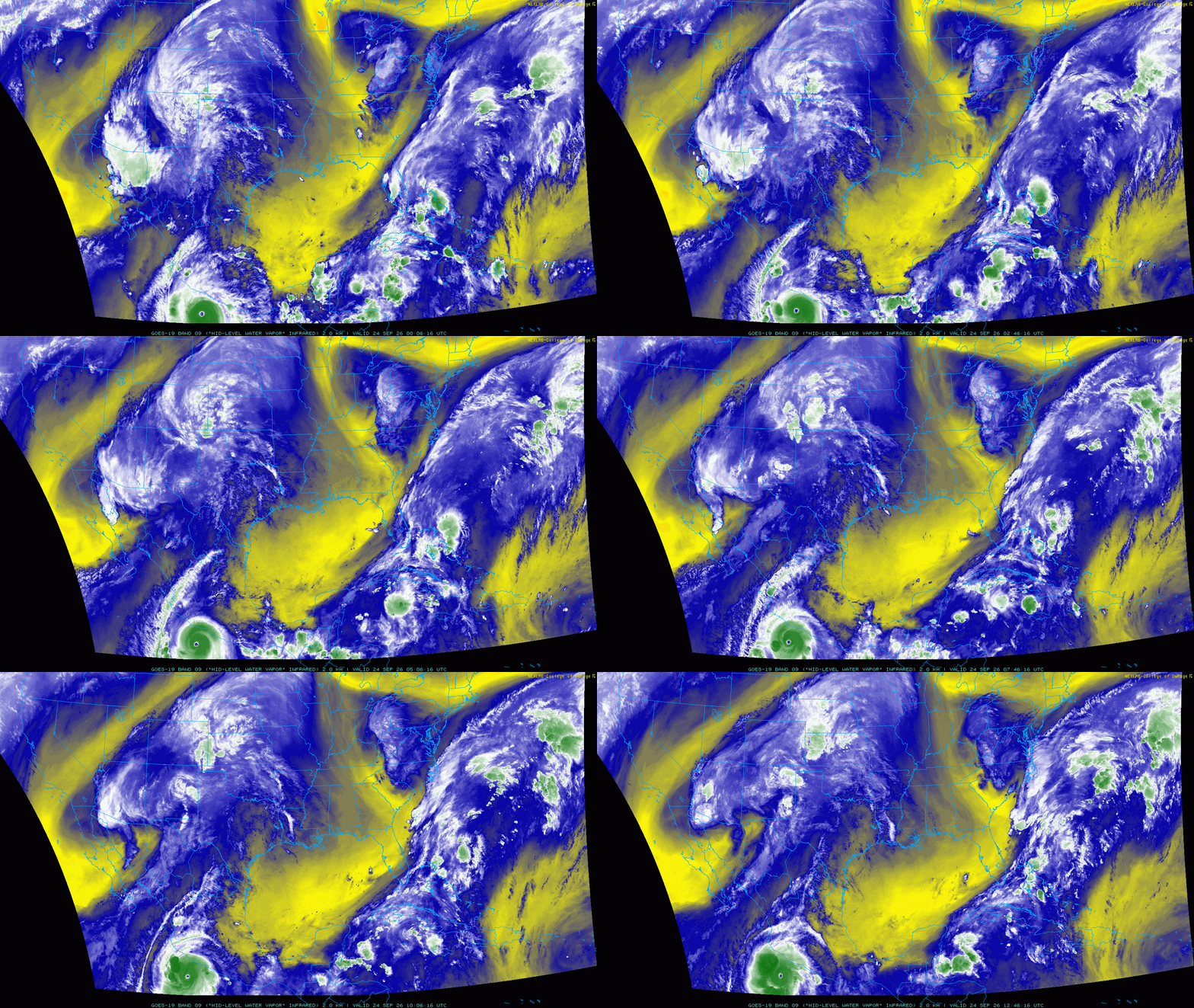
GOES-East water vapor animation from early Thursday
Several embedded shortwaves ejecting northward from the subtropics are helping to wring out some of that moisture plume. Unfortunately for us, these disturbances have been tracking too far southeast to directly impact the Boulder-Denver corridor. Radar has been plenty busy across eastern Colorado over the last 24 hours—just not particularly close to home.
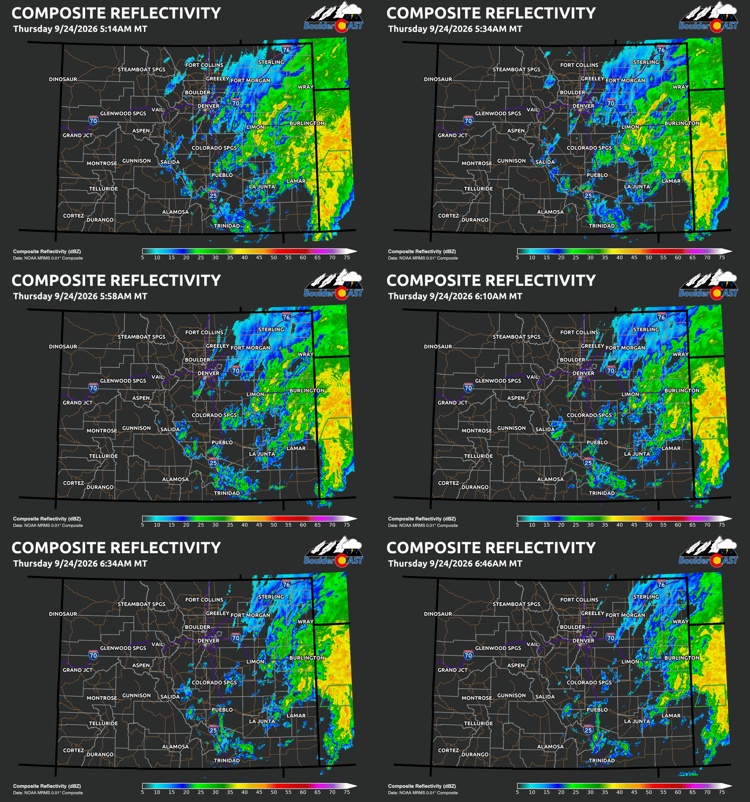
Southeastern Colorado has been especially wet, with widespread precipitation continuing for much of the night. Rainfall reports of 1 to 2 inches are common in the area, with locally up to 3 inches observed.
Thursday: More Clouds Than Rain (Again)
Thursday looks quite similar to Wednesday across the Front Range. Deep moisture will keep skies mostly cloudy to overcast for much of the day, limiting daytime heating, instability, and, consequently, our overall rainfall potential.
A few isolated showers could pop up during the morning and afternoon, but the better opportunity for rain should come this evening into tonight as easterly and southeasterly upslope flow strengthens behind the departing surface low.
The HRRR has been consistently aggressive with showers and even a few thunderstorms developing across northern Colorado this evening and overnight, with Fort Collins potentially sitting in the sweet spot. That said, forecast models have struggled mightily with these unusually moisture-rich monsoonal setups over the last several months, so we’re keeping expectations in check around Boulder and Denver.
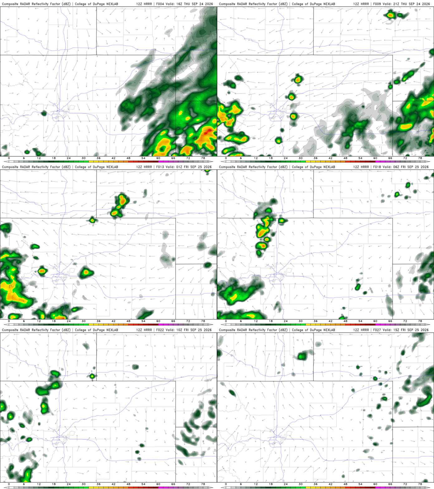
HRRR model-simulated radar animation for Thursday. Mostly quiet around Denver during the day, but keeping an eye on developing showers/storms in Larimer Thursday evening/night.
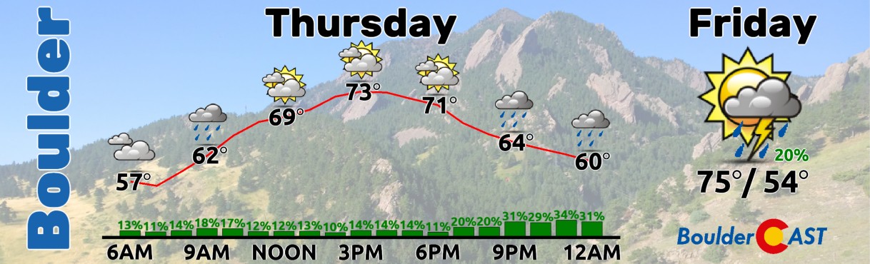
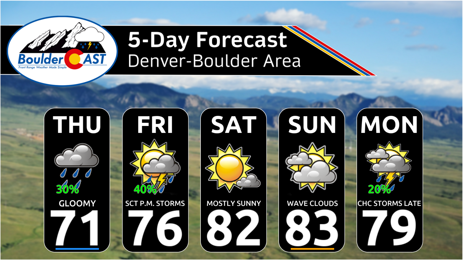
Expect mostly cloudy to overcast skies much of the day with just a 10% chance of a shower through the morning and afternoon. The better chance arrives after 6PM and continues into the evening and overnight, when rain chances may climb all the way to… gasp… 30%!
With all that cloud cover, temperatures will remain on the cool side, with highs generally in the upper 60s to lower 70s across the lower elevations. We may sneak in a few brief peeks of sunshine, but don’t expect much.
Friday: A Bit More Sun with Storm Chances
The core of the monsoon moisture plume will shift east of the Front Range Friday, but one final shortwave could keep things interesting before we finally dry out.
After some patchy morning fog, expect partly cloudy skies through the day. A wave of thunderstorms may develop off the higher terrain during the late afternoon or early evening along a sweeping boundary and move eastward across the Plains. This could be our best opportunity for meaningful rainfall all week.
Highs will rebound into the mid to upper 70s.
Weekend: Drying Out
By Saturday, a shortwave ridge builds in from the south and southeast, shutting down precipitation chances. Look for plenty of sunshine and highs near 80 to 83°F. Sunday should remain dry as well, although an increase in wave clouds is likely. Temperatures will again climb into the low to middle 80s.
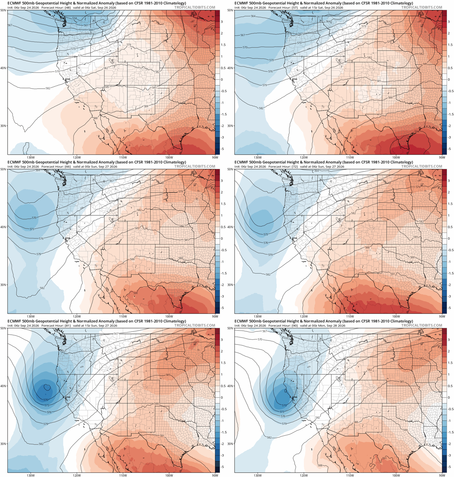
This weekend brings quiet weather to Colorado as a ridge builds in over the area.
Next Week: Things Could Get VERY Interesting
This is where the forecast gets considerably more complicated. And more uncertain.
Early next week, the southern Rockies and southern High Plains could become the battleground for several major weather features. The tropical Pacific is already getting interesting, with Hurricane Polo potentially interacting with Hurricane Odalys via a Fujiwhara-type interaction. There is considerable uncertainty over exactly how that interaction unfolds, where Polo ultimately tracks, and when/where it makes landfall along the Baja Peninsula.
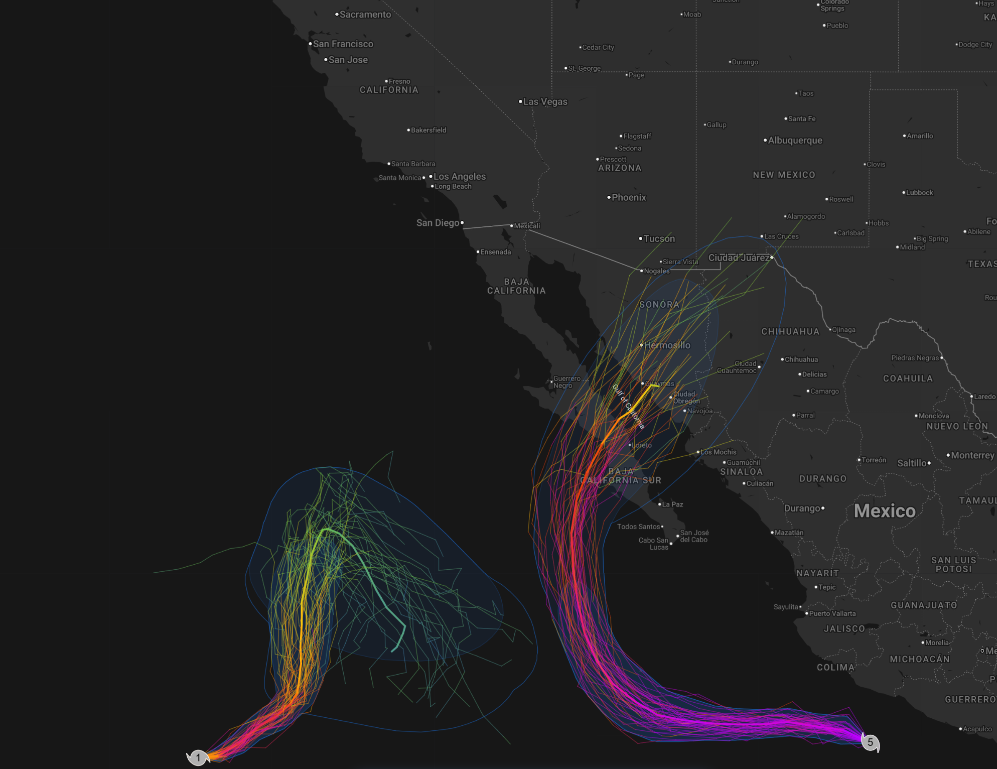
Current ensemble track forecasts for Hurricane Odalys (left) and Cat 5 Hurricane Polo (right).
At roughly the same time, the first significant autumn trough of the season will be diving into the western United States from the northern Pacific.
And, naturally, the models have a few different ideas about how these two features could interact.
- Scenario #1: The trough remains progressive, quickly crossing the southern Rockies and bringing a brief period of cooler temperatures and precipitation to the Front Range.
- Scenario #2: The trough digs farther south and closes off near the Four Corners, slowing dramatically and potentially establishing a prolonged fetch of moist upslope flow into eastern Colorado with a tap into the Gulf of Mexico.
- Scenario #3: The trough phases with the remnants of Polo, drawing tropical moisture northward and potentially supercharging the entire event.
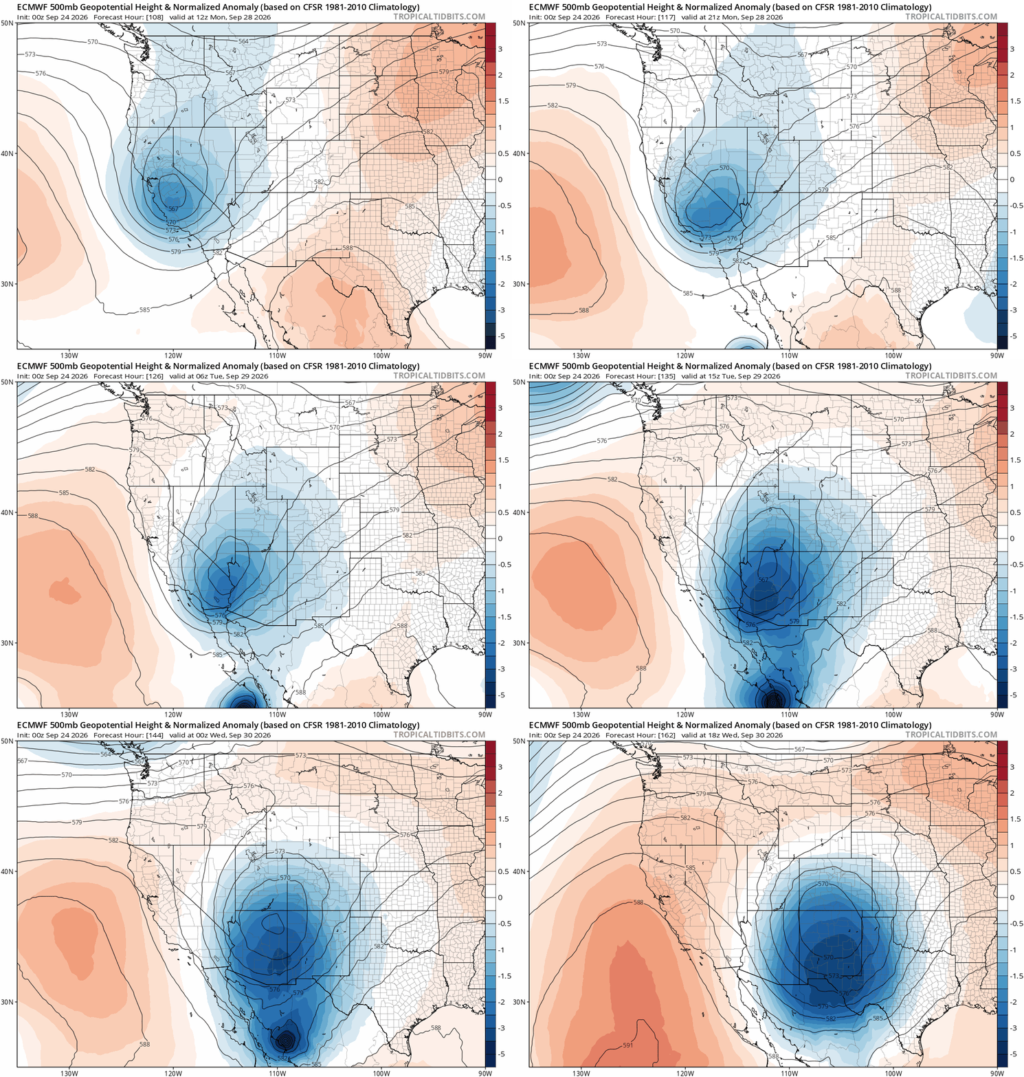
How will Polo’s remnants and the Pacific trough interact and/or phase?
That third scenario remains the least likely of the bunch, but it’s certainly not impossible. In fact, the latest Euro run is showing almost exactly that, with Polo’s remnants phasing remarkably well with a closed upper-level low near the Four Corners around Tuesday or Wednesday of next week.
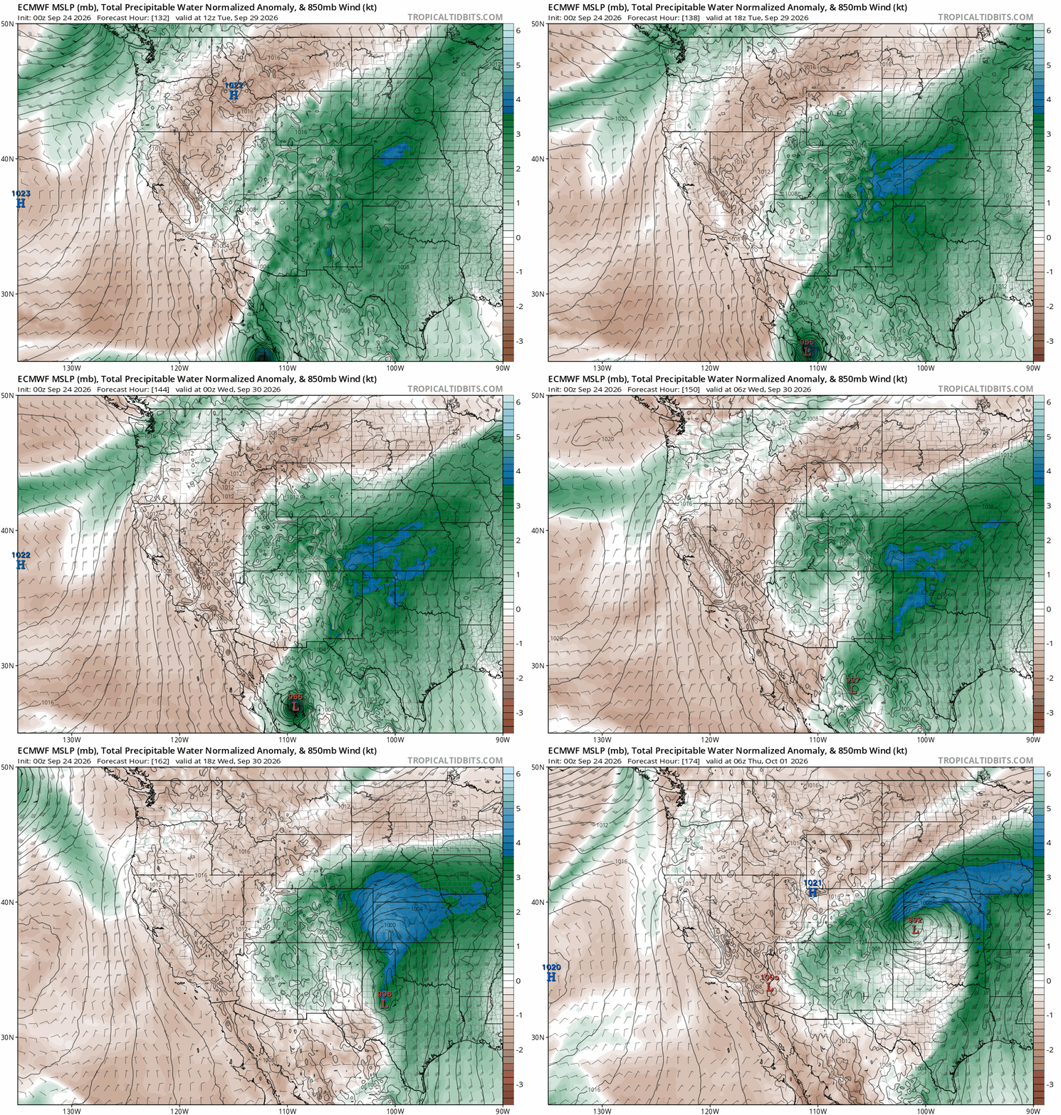
And how much rain would the resulting “Perfect Storm” scenario produce around here? Three to six inches! Yes, you read that correctly.
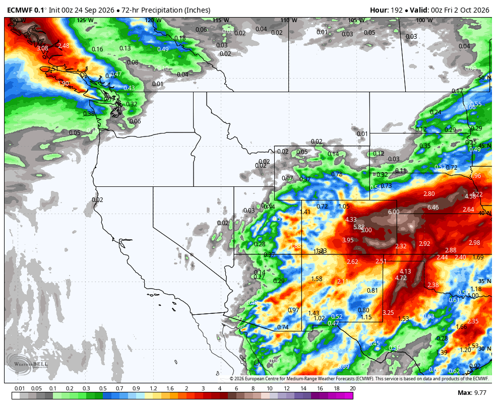
Euro model forecast precipitation for Tue-Thu of next week. Huge but unlikely totals are indicated for eastern Colorado in the “Perfect Storm” scenario.
Before anyone starts planning their ark, however, there is a massive caveat: that particular model run is a major outlier. The ensemble guidance makes that abundantly clear, with the operational Euro solution—the blue line below—standing well above nearly every other member and producing more than 4 inches of rain in Denver.
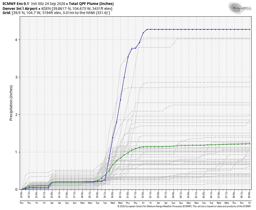
Wet weather likely Tue-Wed of next week, with amounts uncertain for now.
There is simply a lot that still needs to be sorted out between now and Tuesday. Among the biggest questions:
- What happens with the Fujiwhara interaction between Hurricanes Polo and Odalys? Where does Polo ultimately go, and when does it make landfall?
- How far south does the Pacific trough dig? Does it remain progressive, or does it cut off near the Four Corners?
- Do the tropical and mid-latitude systems phase? If so, how efficiently can they transport deep subtropical moisture into Colorado and where would the best upslope reside?
The answers to those questions will determine whether next week is simply a modest autumn cooldown with some showers—or something much more substantial for our drought.
For now, our extended forecast remains considerably more conservative. Monday will likely be the first day we see the pattern begin to change, with increasing clouds, cooler temperatures in the 70s, and a chance for late-day showers and thunderstorms as the approaching Pacific trough begins tapping some moisture from the southwest.
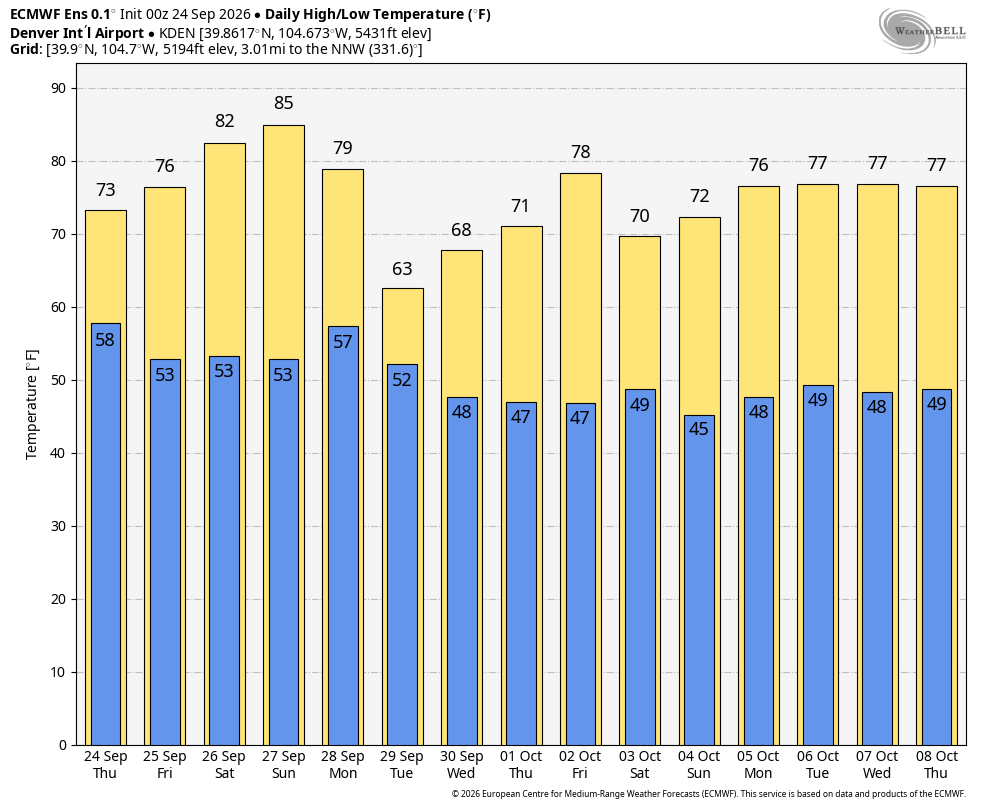
Regardless of exactly what unfolds next week, our temperatures will cool off considerably heading into Tuesday and Wednesday as the trough enters the region. Models mostly indicate highs in the 55 to 60° realm, but there is plenty of spread from the upper 40s to upper 60s. The Mountains above treeline will likely see their first widespread blanket of snow during this window as well, totally normal for this time of year, and about time!
So, all things considered, enjoy the sunshine and warmer temperatures this weekend. Next week will turn colder and could get quite interesting.
Spread the word, share our crazy Colorado weather:
Go Premium, get all the perks.
Daily Forecast Updates
Get our daily forecast discussion every morning delivered to your inbox.
All Our Model Data
Access to all our Colorado-centric high-resolution weather model graphics. Seriously — every one!
Ski & Hiking Forecasts
6-day forecasts for all the Colorado ski resorts, plus more than 120 hiking trails, including every 14er.
Smoke Forecasts
Wildfire smoke concentration predictions up to 72 hours into the future.
Exclusive Content
Weekend outlooks every Thursday, bonus storm updates, historical data and much more!
No Advertisements
Enjoy ad-free viewing on the entire site.












Leave a Reply
You must be logged in to post a comment.