Welp….you were probably disappointed with your snow amount waking up on Halloween this year. We sure were! We review the snow totals from across the Front Range, discuss why many locations saw less snow than expected, and talk Mountain snow heading to Colorado.
Snow totals
The official snow totals from the storm earlier this week were 0.3″ in Boulder and only a trace in Denver. Shown below is our updated snowfall forecast map created Tuesday morning. The observed storm totals per location are contained in boxes. Green ones indicate that the observed snowfall was within one inch of the given forecast range, while red was outside the scope of our forecast.
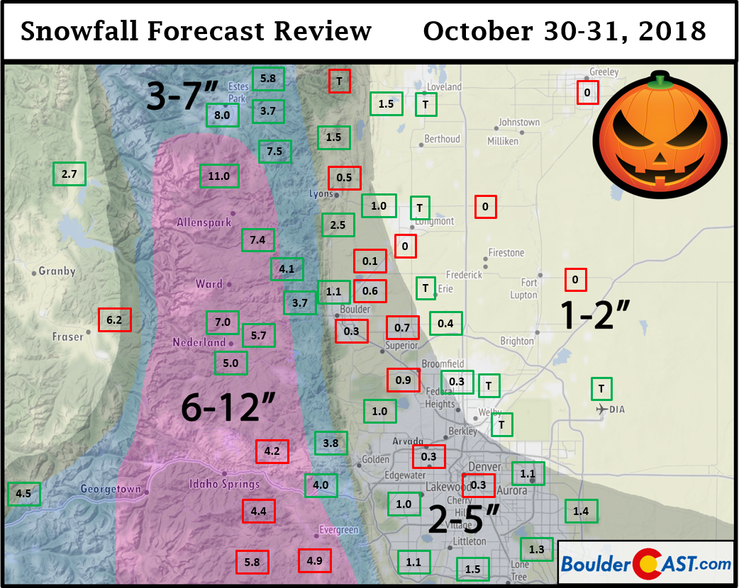
Results of the forecast overall were hit-or-miss. The lower elevations ended with less almost everywhere. The Foothills verified fairly well, though Jefferson County saw totals only in the 4 to 6″ range. Keep in mind the NWS had this area of JeffCo in a Winter Weather Advisory for 5 to 10″ of snow. The highest totals, including up to 11″ near Allenspark, were reported in western Boulder County where we predicted 6 to 12″, but was not included in the NWS Advisory. Regardless, it wasn’t a great result in the grand scheme of things for anyone.
What happened?
Why did snow totals end-up so much lower than expected across the Metro area? Let’s take a look.
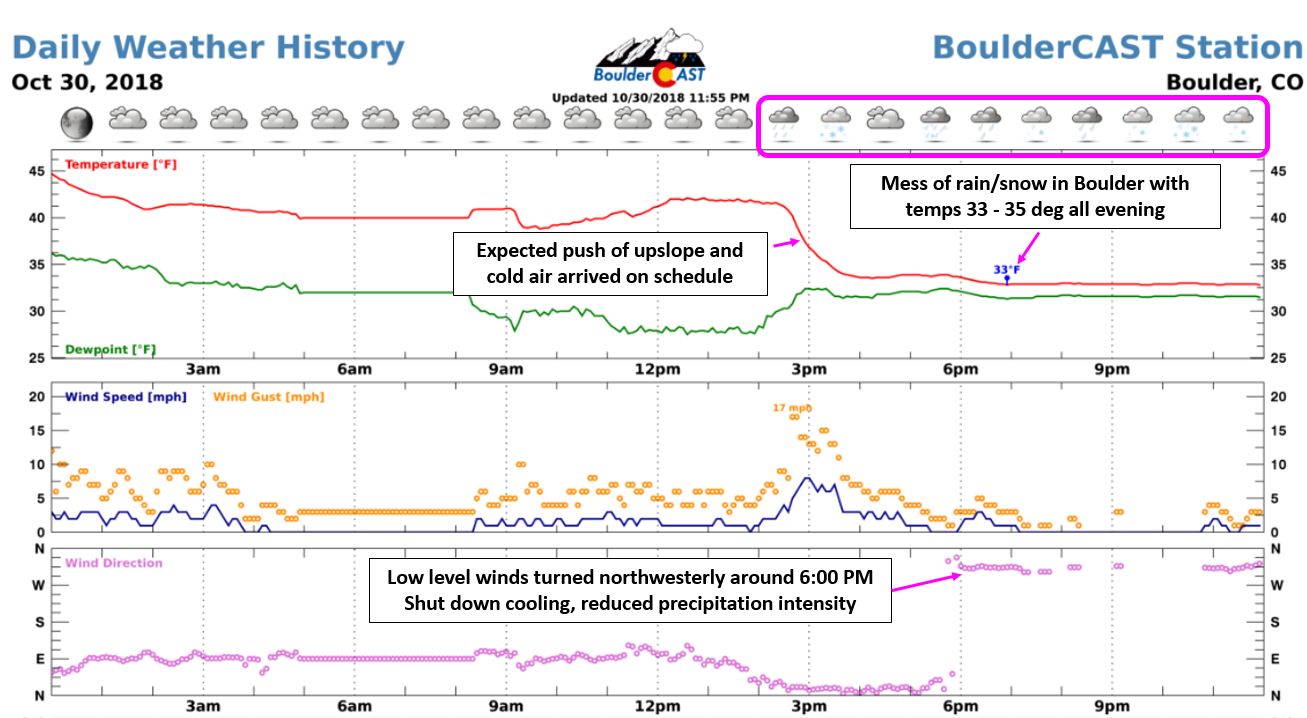
The diagram below shows the weather observations from BoulderCAST Station on Tuesday. The high for the day occurred at midnight Tuesday morning (45), with temperatures hovering near 40 degrees through the day under cloudy skies. By late afternoon, the anticipated colder surge of upslope arrived from the northeast. Notice the drop in temperatures to the middle 30’s, the gusty winds, and wind direction shift to northeast accompanying this cold front of sorts. Precipitation also started to become more widespread at this time, mainly as a rain/snow mix across Boulder and Denver, with all snow above 6000 feet. However, the surge of upslope, near ground-level at least, didn’t last long. By 6:00 PM, we saw winds shift to northwesterly and temperatures hold steady in the 33 to 35 degree range through the evening. This resulted in a lot of rain/snow north of Denver, with any snow that did occur melting on impact. Lower elevation areas from Longmont to Greeley (below 5000 feet) saw almost all rain. So yes, temperatures were an issue, and this is something we were concerned about. Ultimately, though, we hedged our bets that it would be JUST cold enough for some accumulating snow in most locations.
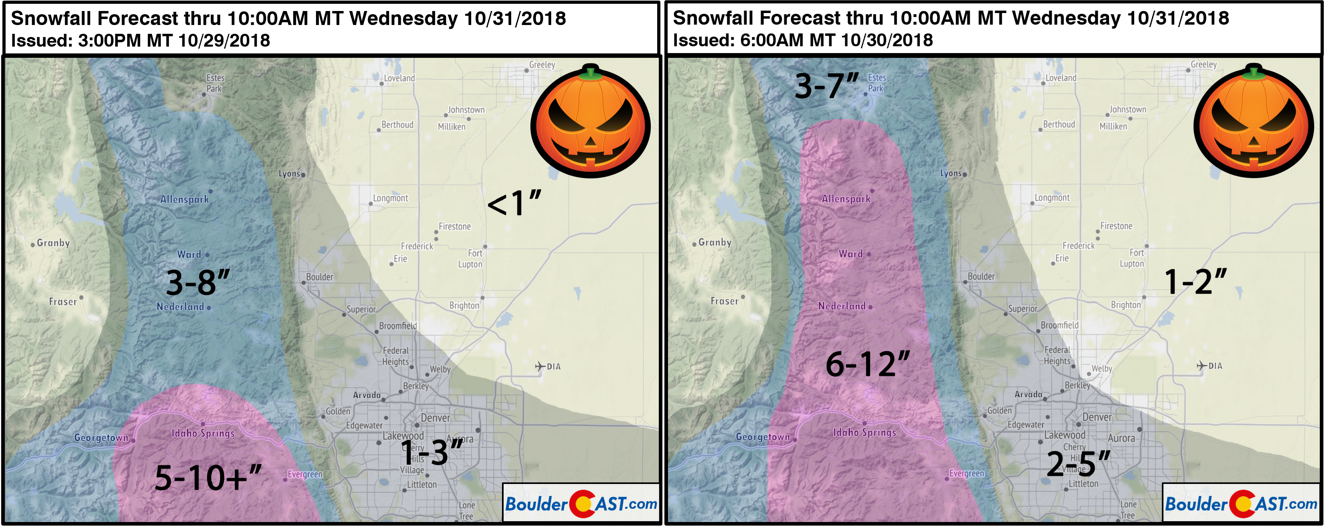
We expected the bulk of the storm’s energy to remain south of Denver in the days leading up to the event, with Boulder on the fringe of it all. However, in the final 24 to 36 hours, the models came in further north with the storm. Not just that, there was fairly good agreement between almost every model for this. The GFS, the NAM, the Euro…you name it. This was the main reason that we bumped up our snow totals for the region by about 50% across the board. You can see our original snowfall map from Monday afternoon below on the left, and our updated snowfall map on the right from Tuesday morning. Our initial forecast would have verified significantly better, but still not perfect.
In the GFS ensemble precipitation forecast below from Monday, the median forecast precipitation total was 0.55″ in Denver for the event, with a max around 0.85″ and a min near 0.25″. Also note the relatively tight clustering which suggests lower model uncertainty. As it began, confidence was high for a half inch precipitation event in Denver with even more in Boulder.
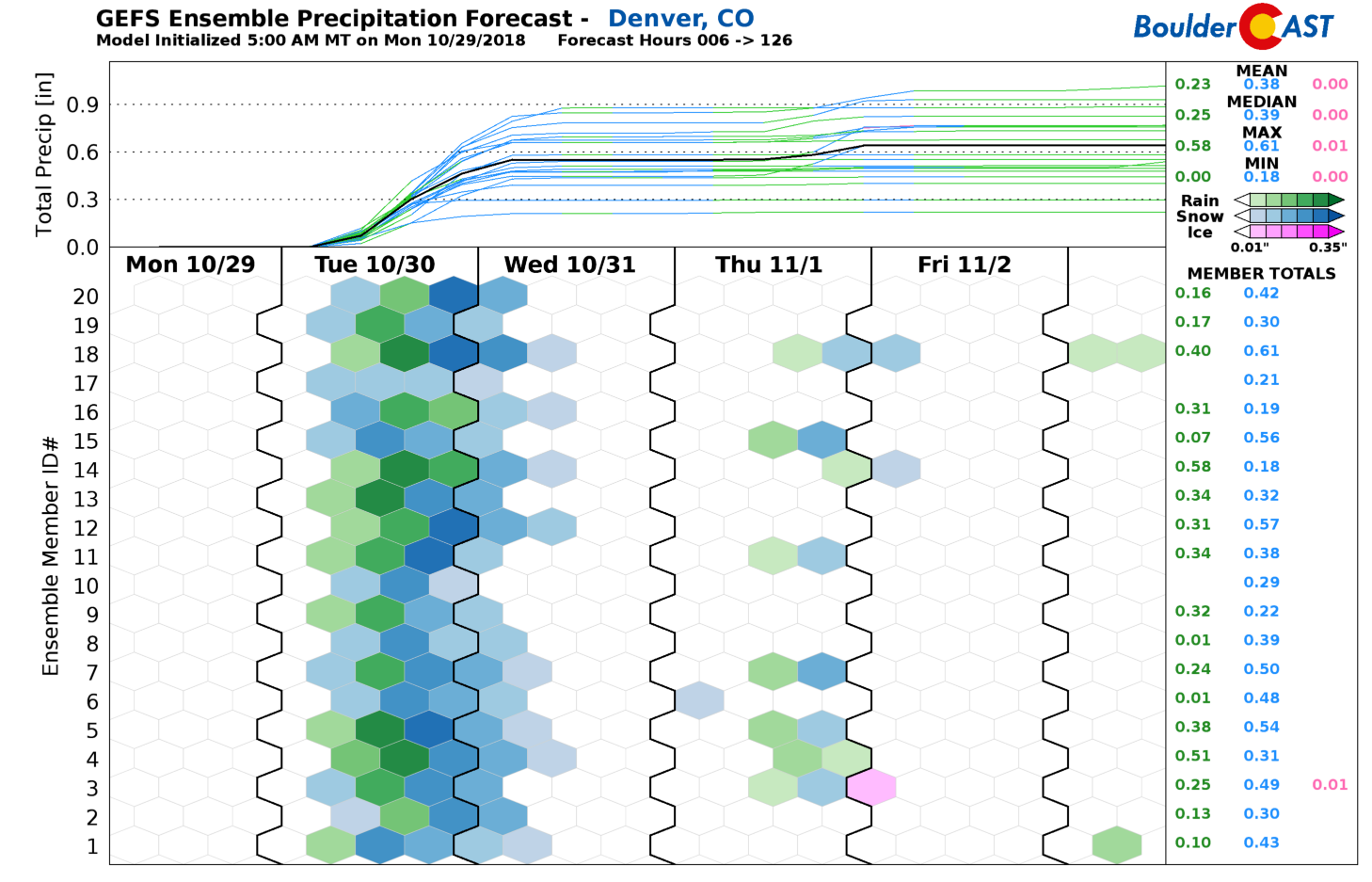
GFS ensemble precipitation forecast plumes for the event showing more than 0.5″ of precipitation as the median in Denver.
As it turned out, the entire Denver Metro area, with the exception of the southern fringes, received right around 0.25″ of liquid from the storm. Boulder reported 0.28″ and Denver 0.22″. This was the absolute lowest, worst case scenario for this storm, less than half of the best forecast….even lower than the lowest ensemble member.
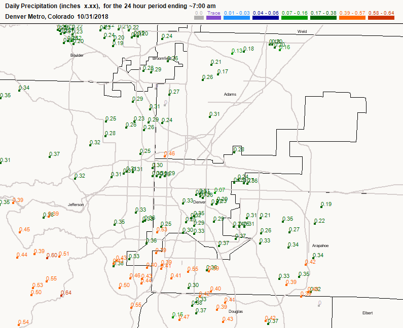
Precipitation totals across the Front Range on Oct 30-31, 2018
As we have shown, the issue wasn’t only temperatures. The storm just plain didn’t show up as the models were advertising. Lacking the sustained upslope. Lacking the widespread precipitation. Lacking the cold air…the snow just didn’t have a chance to accumulate across most of the lower elevations before wrapping up before dawn on Halloween. Driving to work on Wednesday, there were distinct “higher” elevation areas which were cooler that did have a modest coating of snow, such as the big rise on 36 heading east out of Boulder. These were the areas where temperatures fell closer to 32 degrees.
Despite the busted forecast, this was Boulder’s second White Halloween in a row, by the definition of at least 0.1″ of snow being reported. If you recall, we had 0.2″ of snow last year on the Day of the Dead.
Looking ahead to the weekend
As we discussed in our weekly outlook on Monday, northwest flow will take us into the weekend and early next week, with plenty of moisture to produce snow near and west of the Continental Divide. The northern Mountains will be favored heavily, with some northwest-facing peaks likely pickup up more than a foot by the end of the weekend. Winter Weather Advisories are posted, generally above 10,000 feet, everywhere north of Interstate 70 right now.
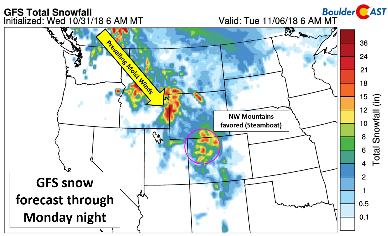
GFS snowfall forecast through early next week
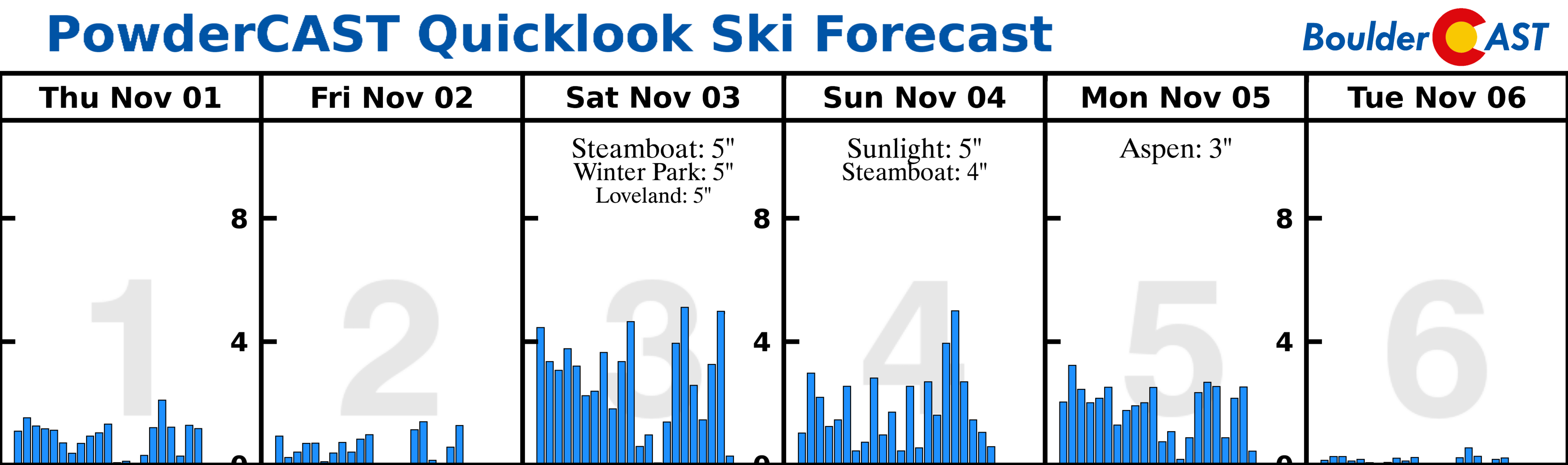
Many of the ski resorts will see a little snow on each of the coming days, with Steamboat making out the best, as is typical for this type of atmospheric pattern.
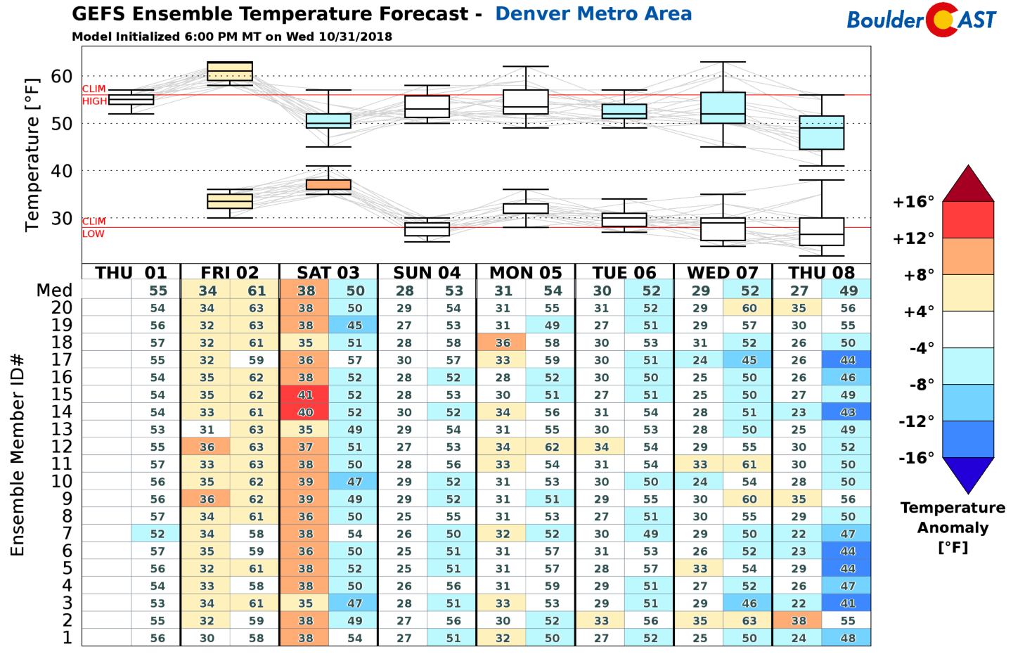
Down on the Plains in Boulder and Denver, very little moisture will make it to us. We should mainly be dry…the one exception being late Friday into Saturday where a few isolated rain showers may be possible. We will side towards almost everyone remaining dry though given the downslope pattern. Temperatures will be seasonal, if not slightly cooler than normal for the next week or so. Friday is set to be our warmest day. Enjoy those sweet, sweet 60’s. Don’t mind those gusty winds!
Share this post:


You must be logged in to post a comment.