A potent spring storm and stark disagreement in the solutions offered up by the weather models made for a difficult forecast leading into last night’s snow event. We talk totals and take a look at just how uncommon snow in late May is for Boulder.
L
ast night can safely be considered the biggest bust of the year for the American GFS model, at least in the Denver area. Run after run leading up to the storm, the GFS was predicting temperatures no where near cold enough for snow across the Plains last night, not even the slightest hint from a single one of its 20 ensemble members. It was predicting such a strong influx of warm and moist air from the Gulf of Mexico that it was impossible for rain to change to snow below 6500 feet elevation. The local weather media tends to base their forecasts and graphics primarily on the predictions of the GFS model, so it’s no surprise that basically no one else had much if any snow in the forecast last night. The final run of the GFS before the snow began, initialized at 6:00 PM Monday evening, did eventually shift cold enough for some snow. At this point, though, it was a case of “too little too late” and many people were caught off guard.
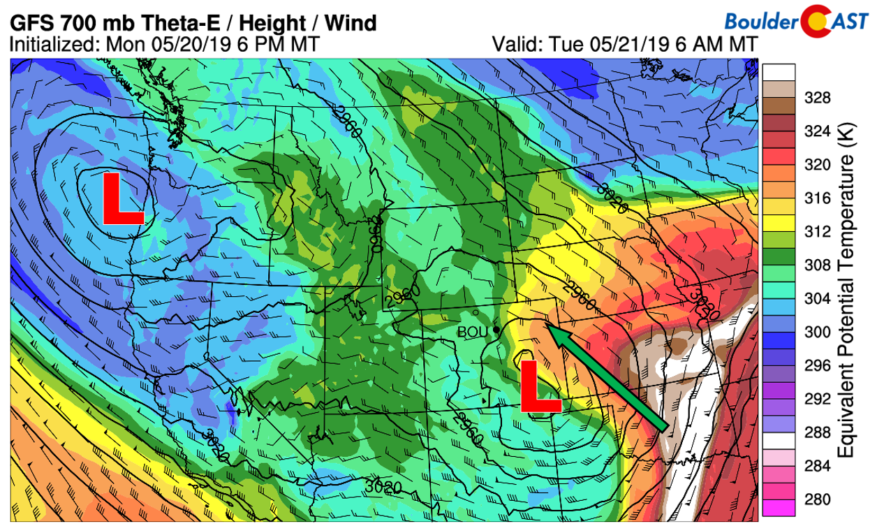
GFS 700mb theta-e forecast for Tuesday morning. This parameter is a quantity that captures both temperature and moisture
As expert Front Range forecasters (toot, toot!), we know when to disregard the GFS…and that is exactly what we did last night. There was a slew of other supporting evidence to suggest that rain would indeed turn to accumulating snow Monday night across the entire Front Range. The regional NAM model, which doesn’t usually do that great in our area, nailed the forecast. In fact, the NAM had been showing snow in Boulder and Denver for several days, and didn’t even bat an eye in its prediction of snow levels dropping below 4500 feet Monday night (shown below). If you recall, we also declared the NAM as the winning model for the biggest storm of the season, the March 13th Bomb Cyclone.

NAM model-derived snow level forecast for Monday night at midnight. All snow is indicated everywhere up and down the Front Range.
In addition to the NAM, we also had marginal support for snow from the European model. It wasn’t quite as cold as the NAM, but it definitely was leaning towards some snow for the lower elevations. Finally, many of the high-resolution and short-range models were indicating the potential for numerous inches of heavy wet snow late Monday evening and overnight, somewhere in 3 to 8″ range for the Denver Metro area. These models do typically tend to bias a little high for snow, especially late in the spring season. However, we did mention and consider these in our forecast for the event.
All of the model evidence led us to predict a fairly good chance of snow across most of the Metro area with totals up to 3″, especially on the western and southern ends of Denver. Shown below is our snowfall forecast map issued Monday morning with actual storm totals overlaid in boxes. Green boxes indicate that our forecast verified to within one inch of the observed snowfall. Red did not.
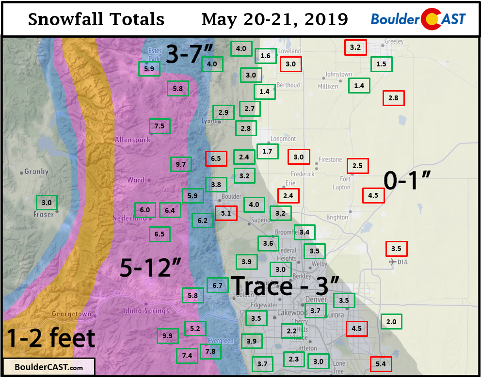
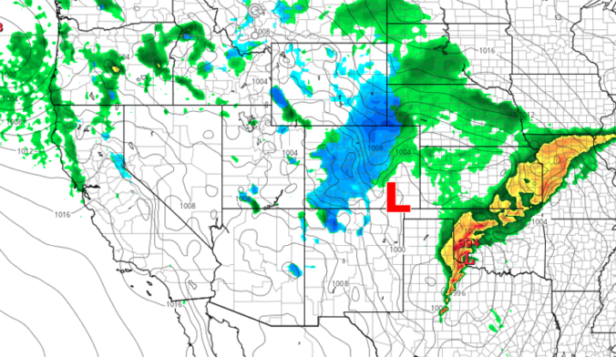
Our snowfall forecast turned out fairly good overall, though totals did come in a little higher than even we expected. The shear amount of moisture available with this storm system led to several hours of very heavy snowfall Monday evening between 7 PM and 11 PM for much of the Denver Metro area. Most of the accumulation for the entire storm fell during this short, four-hour window. The overnight timing couldn’t have been more perfect to aid in allowing snow to accumulate! The radar image from around 9 PM Monday evening is shown below, with almost all the precipitation detected being snow.

Regional precipitation radar for Denver on Monday May 20 2019 at 9:30PM
In classic fashion, it wasn’t until around 10 PM Monday night that the National Weather Service issued a Winter Weather Advisory for the city of Denver after 1 to 4″ had already fallen. Roads were likely becoming slushy in spots given the intense snowfall rates.
The official snow report overnight in Boulder was 5.1″, with around 3.5″ at Denver International Airport. Surprisingly, we continue to top off our seasonal totals with additional snow.
| Seasonal Snow Totals (Updated May 21 2019) |
|---|
| Boulder | Denver |
|---|---|
| 95.1" | 47.9" |
We probably sound like a broken record at this point, but climatology STRONGLY promises this will be our last snow of the season.
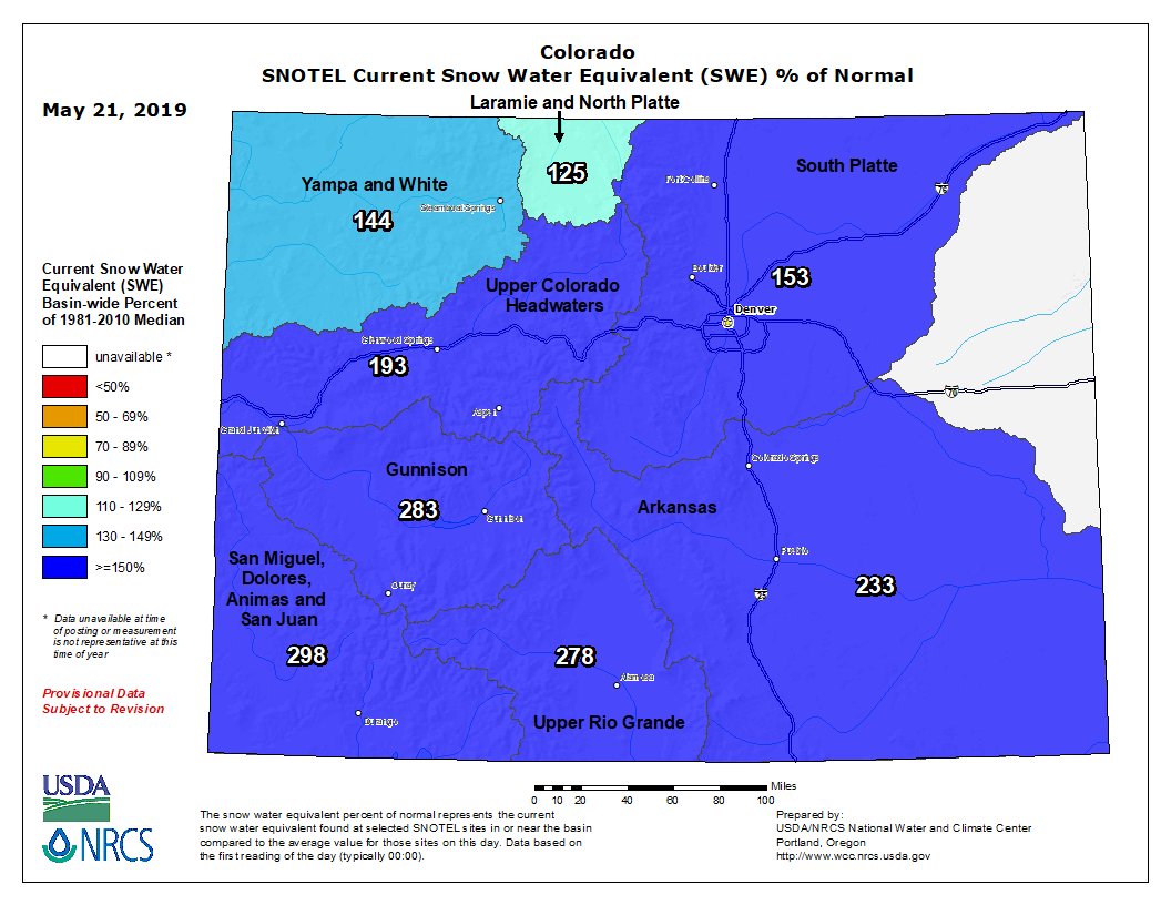
Mountain snowpack continues to soar in Colorado, with statewide values more than 200% of normal right now.
Some of the BoulderCAST team rode up Trail Ridge Road this past weekend via bicycle. It’s currently closed to motor vehicles, and for good reason. Large stretches of the road are impassible due to huge snow drifts. In some areas, snow is 15 to 20 feet deep…

Photo taken along Trail Ridge Road in Rocky Mountain National Park, May 19 2019
How rare is snowfall this late in the season?
The Front Range is no stranger to May snow. In fact, it’s happened 15 out of the last 19 years in Boulder. However, it usually occurs during the first half of the month. Rarely does snowfall grace us with its presence in the latter half of May!
The normal (median) date of the last snow in Boulder is April 26th. Here are the odds of our last measurable snowfall occurring on or before…
- April 3: 10%
- April 17th: 25%
- April 26th: 50%
- May 5th: 75%
- May 16th: 90%
So snow during the second half of May typically occurs about 1 out of every 10 years.
In the 73 years since Boulder snow record-keeping began, today’s snow was the 6th latest ever, and the latest in nearly two decades (since 2002). The 5.1″ reported in Boulder comes in as the 3rd largest snowstorm after May 15th, barely edged-out by the 6.1″ event we experienced just two years ago.

As you can see, snow on May 21st is indeed rare, but not unprecedented. Extremely late-season snow has happened before….and will happen again.
The next few days remain dreary
Our snowy storm is exiting into Kansas and Nebraska today with drier northwest flow now filtering down into the Front Range. Is that a few peeks of sunshine we see already?
We’re not out of the woods yet, at least in terms of gloomy weather. Hot on the heels of the first storm is yet another deep spring system diving southward into California and Nevada.
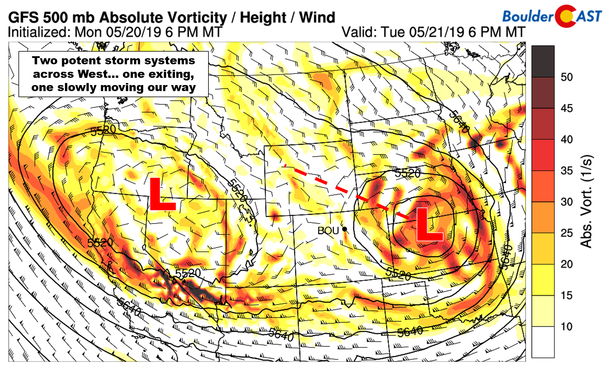
GFS 500mb vorticity map for Tuesday
In fact, these potent low pressure systems are coming so close to one another that we may even see a Fujiwhara interaction in the next day or so. This occurs when two nearby cyclones begin to orbit one another. The Fujiwhara effect is most commonly observed between two close-proximity tropical cyclones, but can happen with mid-latitude storms as well. Can you see the Fujiwhara interaction taking place between the two low pressure systems across the western United States in the 500 mb height animation below?
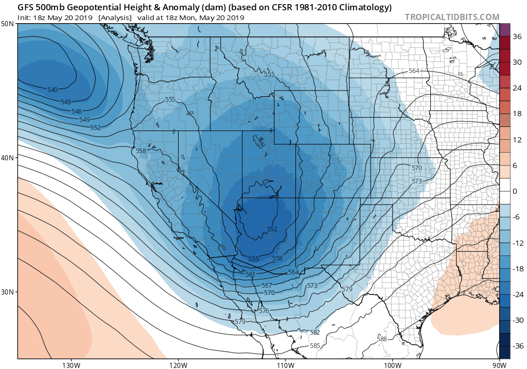
GFS 500mb height anomaly animation showing the departing and incoming storms undergoing a Fujiwhara interaction
The secondary storm will begin to impact the Front Range during the latter half of Wednesday and continue through the day Thursday. This second storm will take a more northerly track than the last one, leading to warmer overall temperatures across northeast Colorado. We expect that most of the precipitation the remainder of the week will fall in the form of rain across the lower elevations, but there is a small chance that some snow could mix in, primarily late Wednesday night and Thursday morning when models are indicating a drop in snow levels possibly as low as 6000 feet. Any colder and we’re once again talking snow for Boulder and maybe Denver. We’ll keep you updated.
Mother Nature resumes our regularly-scheduled weather programming Friday with sunshine returning and temperatures getting back to near 70 degrees. Would you believe that is still below normal for this time of year? This warming trend will continue into the upcoming weekend, which by the way is shaping-up to be leaps and bounds better than the weather in the near-term.
Share this post:
.


You must be logged in to post a comment.