
This week continues right where the weekend left off….unsettled and chilly. Significant snow is likely in the Mountains and Foothills Monday into Tuesday as a strong spring storm moves across Colorado, with light snow possible in the Denver Metro area as well. Drier weather returns towards the end of the week along with warmer temperatures.
Week begins wet & snowy!
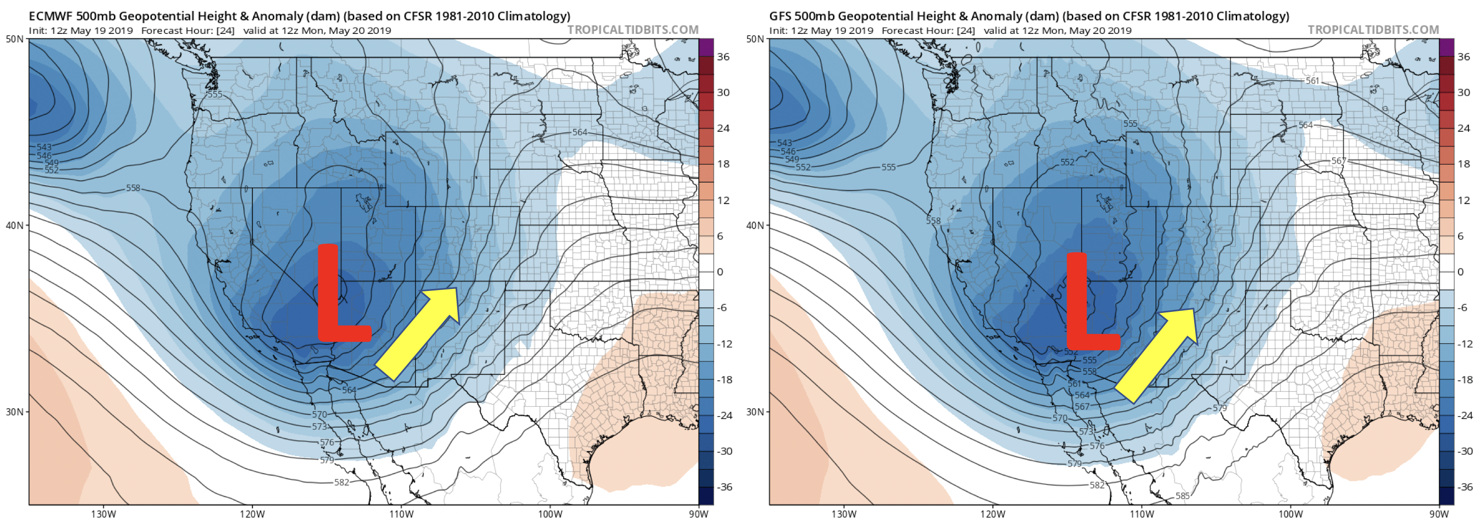
The week will commence cool and wet by late-May standards! This is thanks to a strong trough of low pressure situated over southern Nevada. This favorable southern-track storm is something we mentioned in our forecast update this past Friday. The Euro and GFS models are remarkably similar in position and strength so our confidence in most aspects of the forecast is high moving through the early part of the week. This area of low pressure will be with us into Wednesday, after which a secondary trough currently out in the northeast Pacific Ocean will rotate into the area for Thursday and Friday. Overall it’s going to be an unsettled week!
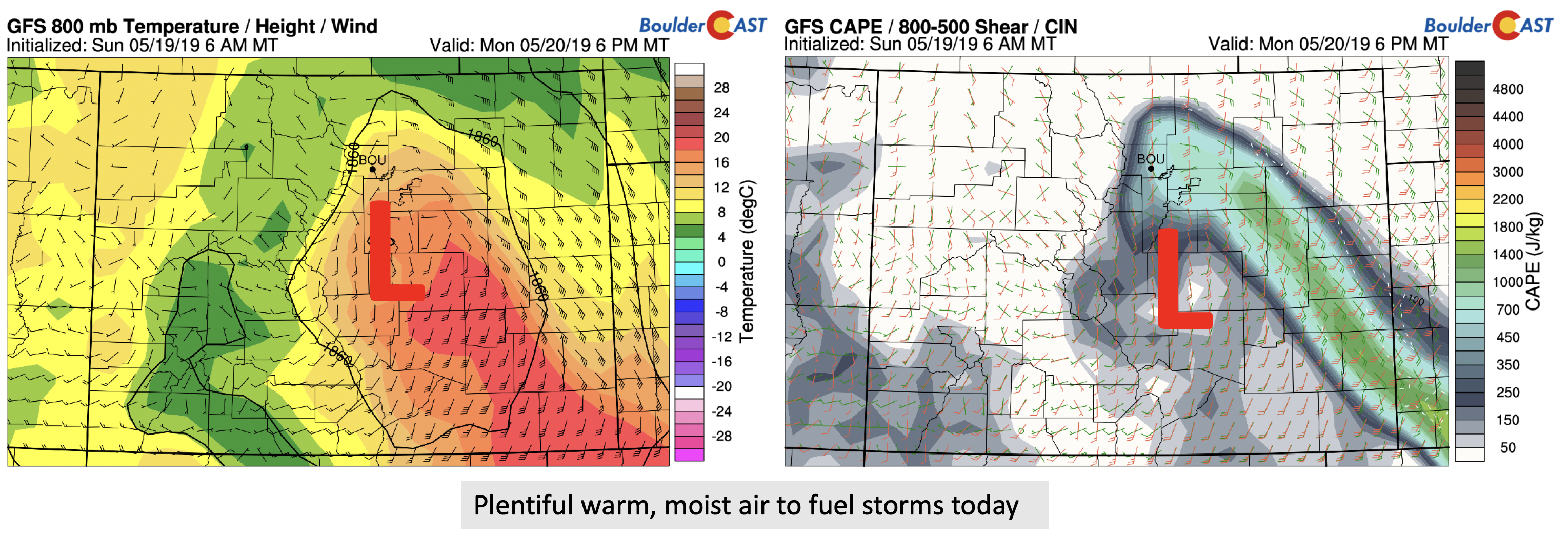
Deep southerly and southwesterly winds are across the area already as of Monday morning. Moisture is prevalent from the Pacific and western Gulf of Mexico (below), which has aided in moistening up the atmosphere overnight and this will continue right through the day Tuesday.

The mid-level trough will be tracking east-northeast this evening and into tomorrow morning. During this time, a surface low will develop across southeastern Colorado and intensity as it tracks northeastward. There are some differences in the models – namely, the NAM appears biased too cold and the GFS too warm. At this point, we are going somewhere in between the two solutions. Nevertheless, enough moisture and warm air will be pumping into the area today to allow widespread rain and some embedded thunderstorms into the early evening. The GFS, although clearly biased too warm, indicates near 600 J/kg of CAPE and warm near-surface air. Despite this, we’re forecasting highs likely remaining in the low to middle 40’s for the Metro area Monday thanks to low clouds, rainfall and persistent upslope
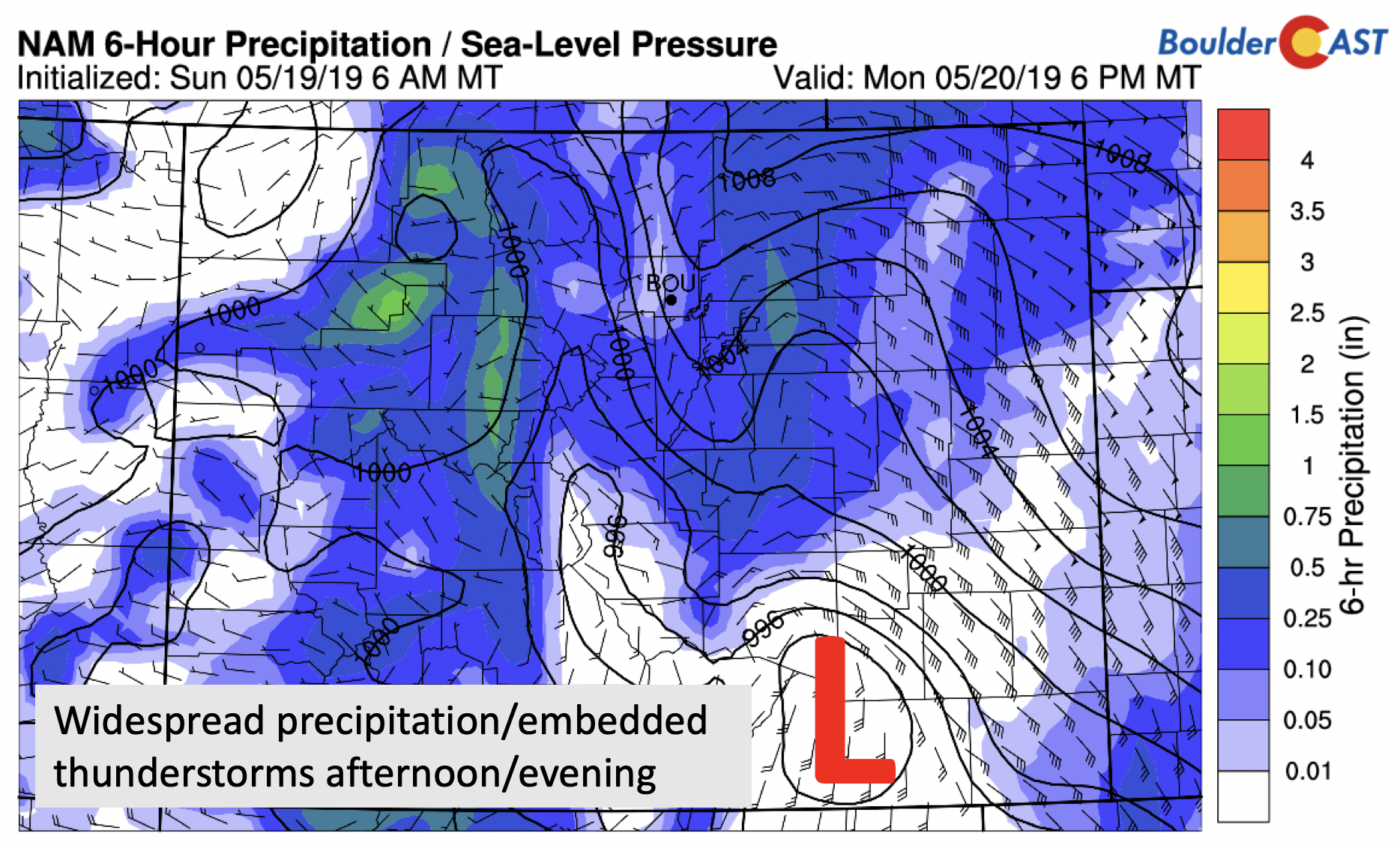
The surface low will take a similar track to that of our spring blizzard back in March, progressing across far southeast Colorado. Light rain and drizzle will be present through the morning for many areas. More moderate rainfall and (maybe) a few isolated thunderstorms will develop Monday afternoon and continue off-and-on overnight into Tuesday. This is the time-frame when the most intense and widespread precipitation will be present across the Front Range.
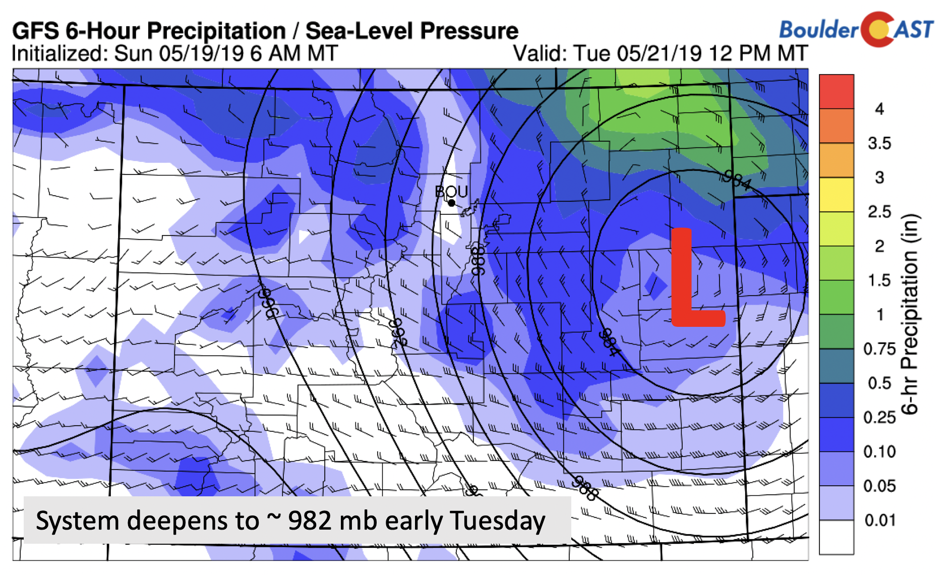
By mid-day Tuesday, the storm will deepen to around 982 mb, pulling in some wrap-around moisture and eventually downslope flow in the afternoon or evening. After this point, gusty winds and colder air will take over Tuesday night and early Wednesday. Highs Tuesday will once again stay in the 40’s most likely.
Today and tomorrow are our wettest days of the week, as evident in the bottom right figure from the GEFS model. Both the ensemble guidance and deterministic models indicate the potential for over 1″ of precipitation by Tuesday night, and locally up to 2″ in areas that see the best upslope (primarily Larimer County) or a decent thunderstorm or two.

Surprisingly, we are indeed still concerned about SNOW in late May! As we mentioned earlier, there are considerable differences between the models in the amount of cooling that occurs, particularly Monday night. The colder NAM model brings snow levels all the way down to include both Boulder and Denver Monday night. The GFS on the other hand, is markedly warmer and keeps everything just a chilly rain below 7000 feet elevation.
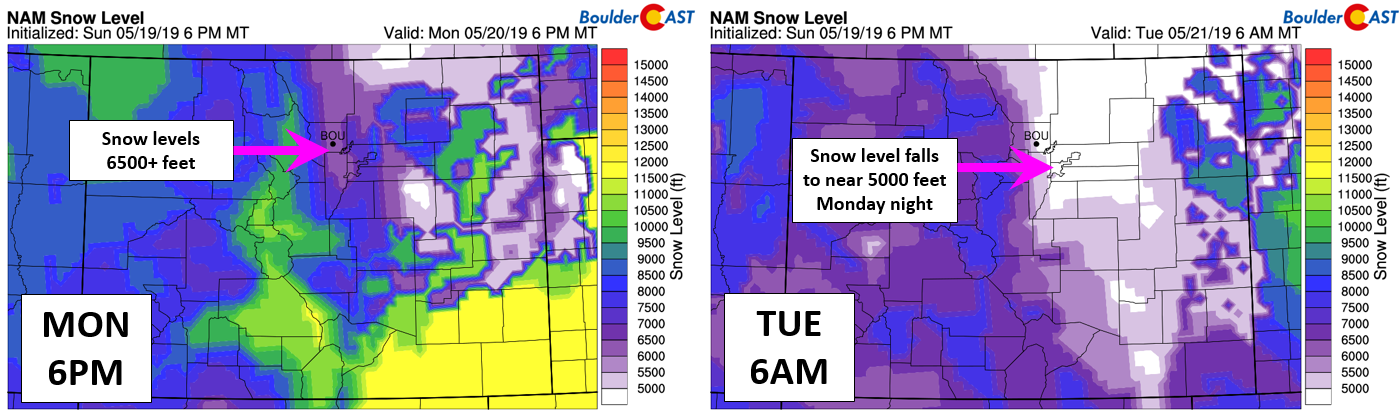
Models generally indicate snowfall amounts in excess of a foot for the highest mountain ranges, with 3″ to 12″ in the Foothills (very elevation dependent). The NAM shows light snow accumulations in the Boulder/Denver area due to its colder solution.
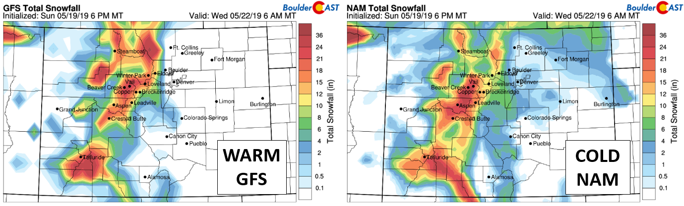
We know the GFS is FAR too warm, and the NAM probably just a shade too cold, but where temperatures ultimately end-up late tonight is difficult to predict. This will make for a tricky snow forecast to say the least. We’re confident that the focus for heavy snow will remain in the Mountains and Foothills, primarily above 7500 elevation. These areas could see 5 to 12″ of snow by mid-day Tuesday. The lower Foothills are looking at amounts in the 3 to 8″ range.
Across the Denver Metro area, things are more dicey as usual this time of year. There is a fairly good chance of SOME snowflakes Monday night, primarily after midnight until just after sunrise Tuesday morning when temperatures cool to near 32 tp 34 degrees at the surface. Most alarming is that high-resolution models and some short-range ensemble forecasts are predicting upwards of 4 to 8″ across Denver and Boulder, with numerous hours of moderate to heavy snow Monday night. We’re basically totally ignoring the GFS solution at this time, and leaning more towards the NAM with some snow all the way down to the Plains tonight. Accumulation, if any, should be light and confined to grassy surfaces. Still, ANY accumulation at all in Boulder or Denver this late in May would be fairly remarkable. There has only been snow later in the season a handful of times in Boulder’s roughly 130-year climatology.
Our snowfall forecast map is shown below. No travel impacts are expected across the lower elevations, though slushy and snow-packed roads are likely in the Foothills Monday night and Tuesday morning.

Snow levels will creep back up in elevation by late morning Tuesday. Then by Tuesday afternoon or evening, a shift downslope is expected to taper off precipitation across the Front Range from south to north.
Eventually warmer and slightly drier to end week
The end to the upcoming week will turn out better than the beginning. We’ll show this transition by comparing the Euro and GFS models at 500 mb below…
On Tuesday, the primary low, as mentioned earlier, will be in southeast Colorado. A secondary system will lurk off the coast of Oregon. Tuesday starts out wet and snowy, but drier air works in under downslope flow by afternoon and evening.

On Wednesday, the early week system tracks into the Dakotas, with the Oregon storm moving into southern Nevada. Wednesday will be drier with just a few chances of isolated showers afternoon and evening showers. Highs return to the mid to upper 50’s.

By Thursday, the next system will then move northeast through the Western US, making for a final push of moisture and rain potential for the Front Range. We expect this chance on Thursday to be scattered in nature with highs near 60 degrees.

Dry and warmer weather takes over Friday with potential highs in the 70’s.
Forecast Specifics:
Monday: Overcast and dreary with drizzle and light rain through the morning. More widespread rain and embedded thunderstorms develop in the afternoon and continue into the evening and overnight hours. Rain will mix with and change to snow down to 5000 feet overnight, with a dusting to a couple inches possible on grassy surfaces. 3 to 12″ is expected above 7500 feet. Highs in the low to middle 40’s on the Plains and middle 30’s in the Foothills.
Tuesday: Overcast with rain/snow showers mixing back to all rain through the morning across the Metro area. Rain tapers off as the afternoon wears on. Light snow in the Foothills tapering off in the mid to late afternoon. Highs in the middle to upper 40’s on the Plains and middle 30’s in the Foothills.
Wednesday: Morning clouds, then some afternoon sunshine with a slight chance of showers. Highs in the upper 50’s on the Plains and middle 40’s in the Foothills.
Thursday: A mix of clouds and sunshine giving way to increasing clouds and a chance of scattered rain showers and storms. Highs in the lower 60’s with lower 50’s in the Foothills.
Friday: Mostly sunny, dry and warmer with highs near 70 on the Plains and upper 50’s in the Foothills.
High Country: Widespread snow showers are on the table for the Mountains on Monday and Tuesday with significant snow totals expected (8 to 16″). Scattered showers/storms can be expected Wednesday/Thursday, with drier weather on Friday. Check PowderCAST for updated forecasts for all the Colorado ski resorts.
DISCLAIMER: This weekly outlook forecast was created Monday morning and covers the entire upcoming week. Accuracy will decrease as the week progresses as this post is NOT updated. To receive daily updated forecasts from our team, subscribe to BoulderCAST Premium.

.
Spread the word, share our forecast!


You must be logged in to post a comment.