Moderate to heavy snow arrived to the Denver Metro area right on-schedule Tuesday making for a messy morning commute. While most of us received our allocated amount of snowfall, localized ridiculous totals were observed in far eastern Colorado on Tuesday — up to 30″ in some cases near the Kansas border. This region was expecting much less snow than this which created a dangerous situation for livestock and on the roadways. We review the storm totals and discuss why this historic snow fell in that region.
At a Glance:
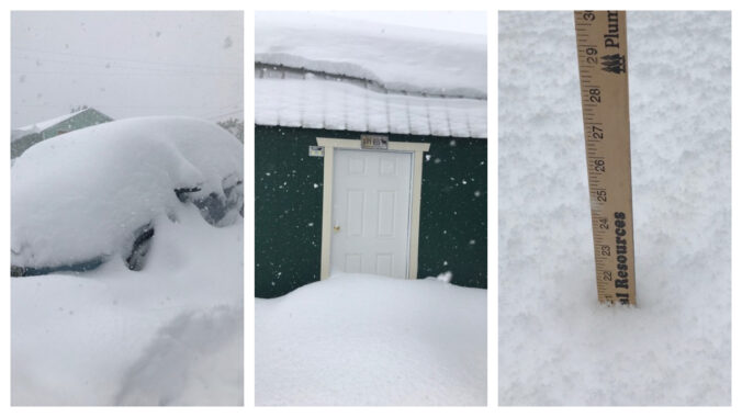
- Heavy snow fell Tuesday morning in the Denver Metro area creating a slick morning commute
- Snow totals ranged from 3-5″ around Denver and Boulder, with up to 9″ in the Foothills
- A localized 15-30″ of snow fell in far eastern Colorado near the Kansas border forcing a closure of I-70
- This snow was massively under-forecast creating dangerous travel and life-threatening conditions for livestock
- Another round of light snow will impact the Front Range on Thursday
We discuss Boulder and Denver weather every single day on BoulderCAST Premium. Sign up today to get access to our daily forecast discussions every morning, complete six-day skiing and hiking forecasts powered by machine learning, access to all our Front Range specific weather models, additional storm updates and much more!

T
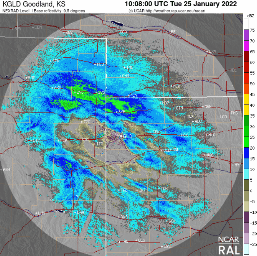
uesday’s snow event went off without a hitch just as forecasted across Colorado’s Front Range. Unfortunately, this means that a wave of moderate to heavy snow was indeed dumping across the Denver Metro area smack in the middle of the morning rush hour window. Heavy snow started in Fort Collins around 4AM, in Boulder by 7AM and into Denver close to 8AM on Tuesday. Here’s a look at the regional radar ending around 8AM on Tuesday when a band of heavy snow was lined up more than 250 miles from the Foothills well into Kansas!
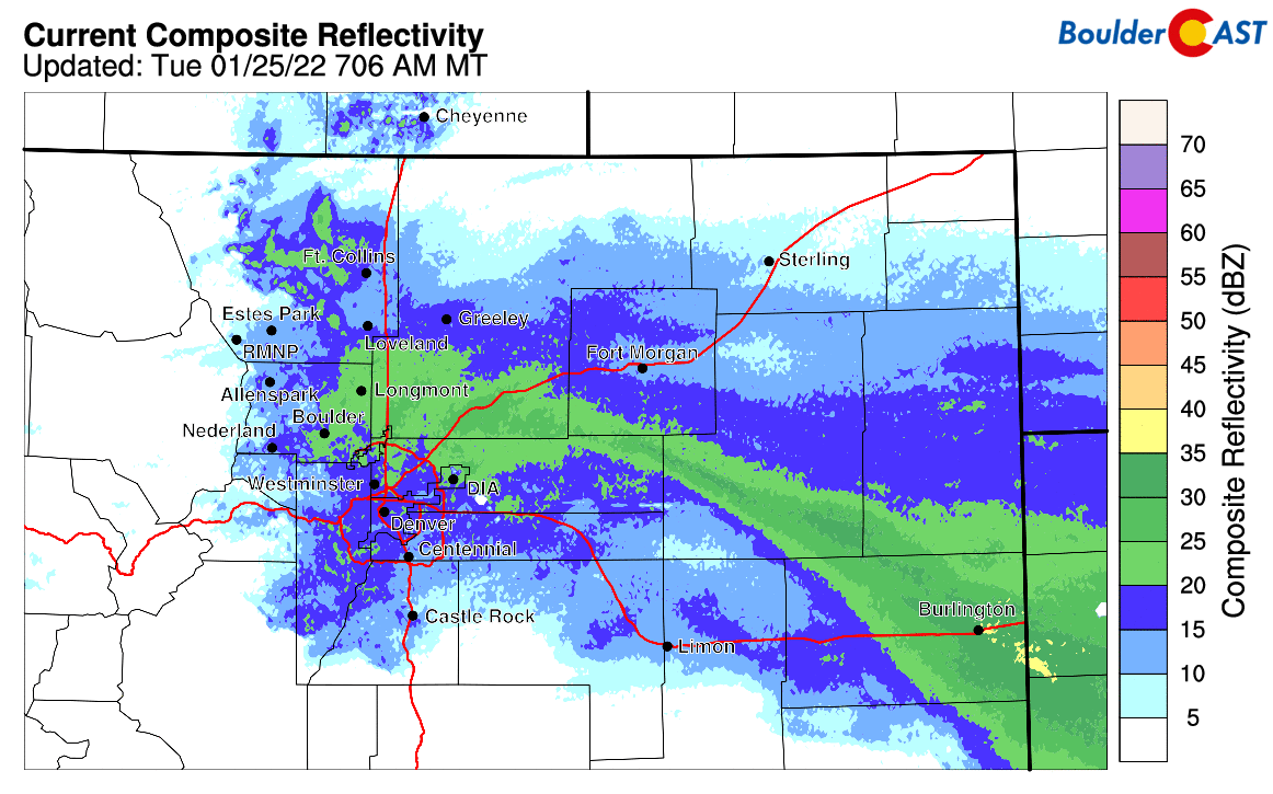
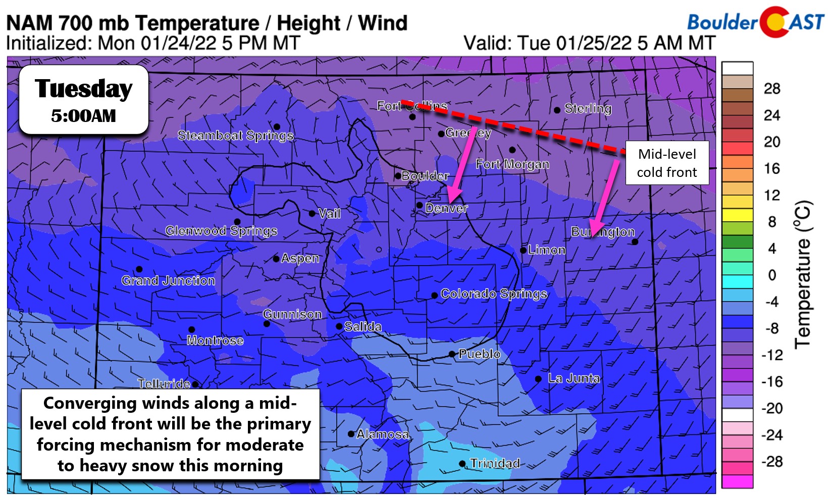
This heavy band of snow was caused by converging winds along a frontal boundary dropping south across eastern Colorado. We measured snowfall rates in the heart of this snow band around 2″ per hour in Boulder. Some places in far eastern Colorado where the winds were clashing more abruptly had peak snowfall rates of 3 to 4″ per hour at times — incredibly heavy snow! Accumulating snow was mostly done in Boulder by midday with only light snow and flurries lingering into the afternoon.
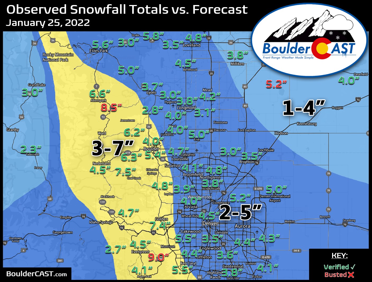
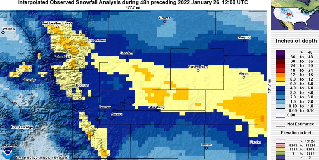
Our snowfall forecast map for this event is shown below with snow totals overlaid. Green values are where our forecast verified correctly to within one inch. Red totals were a bust (or in this case, a boom!). Totals generally ranged from 3-5″ across the Denver Metro area, with 4-8″ in the Foothills. Most areas ended up well within our forecast ranges, albeit on the higher end. Officially Boulder reported 5.4″ of snow, while Denver received a very respectable 5.0″.
Here’s another look at the totals via an interpolated snowfall analysis map. The Front Range did good, but the eastern Plains did even better…
This leads us into the biggest story from the snow event on Tuesday — the absolutely staggering snow totals observed along I-70 close to the Kansas border near Burlington and Bethune Colorado. A narrow region some 25 miles wide by 125 miles long received more than a foot of snow. Localized areas saw historic totals close to 30″ in some cases!
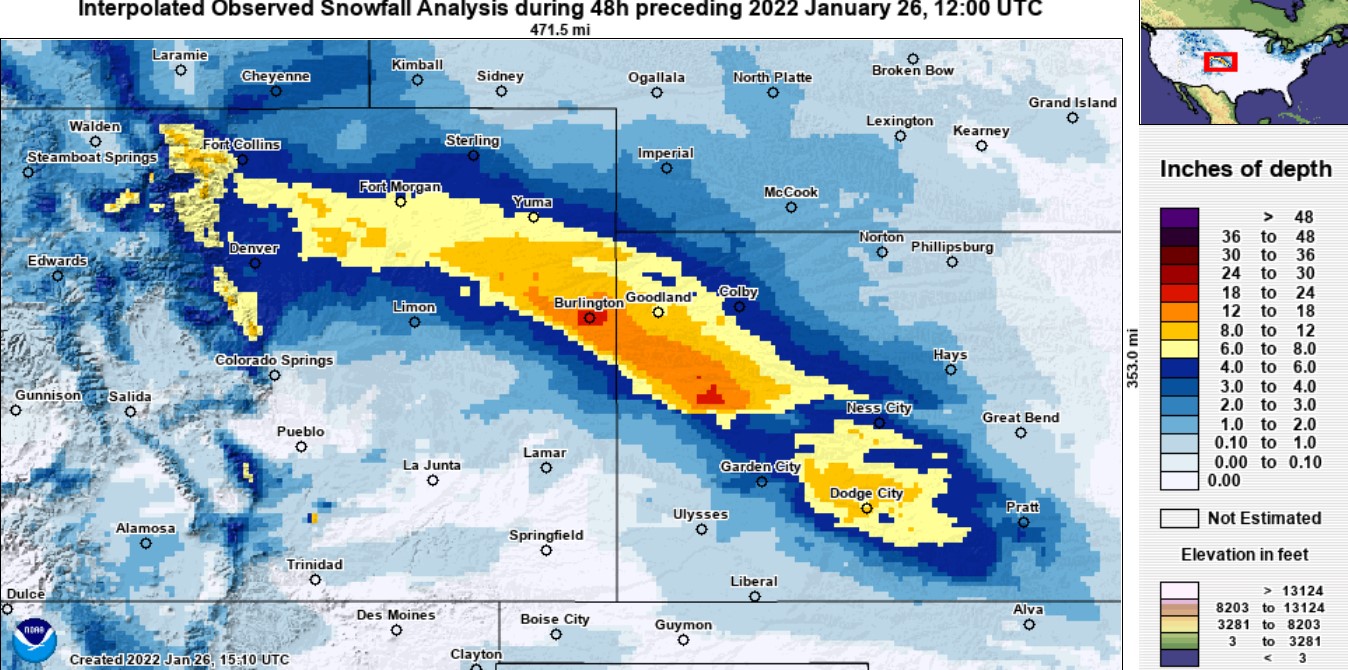
Below is a 12-hour animation from the radar in western Kansas for the Tuesday morning and afternoon timeframe. The stationary snow band sitting over the Burlington area barely moved over the course of the day and dumped snowfall at an AVERAGE rate of around 2″ per hour for upwards of 8 or 12 hours. Interstate 70 became a disaster in both directions and was shut down for many hours between Limon and Kansas.
Check out this video of the heavy snow falling in Burlington. What a mess!
Once you start getting above 20″ in a single day, that becomes historic for anywhere outside of the Mountains in Colorado. For example, Boulder’s all-time greatest one-day snow total is 22.1″ from October 1997. Denver’s is 23.6″ from December 1982. Tuesday’s event was even more extreme in that most of the snow fell in less than 12 hours! In case you are wondering, the Colorado, country and world record 24-hour snow total is currently held by Silver Lake in western Boulder County at 85 inches set back in 1921!
Sadly the forecasting outlets for this region largely let Tuesday’s devastatingly stagnant snow band slip under the radar — no pun intended. There was certainly good model agreement that a band of heavy snow such as this could occur in the general area, but locking down the exact location was a very difficult task. This area was only predicted to get 3-6″ of snow on Tuesday by the National Weather Service. Instead they got five times as much which can certainly create dangerous conditions for any exposed livestock. Had the forecast included note that significantly more snow was at least possible (which it was), ranchers could have made more appropriate preparations.
From our weekly disco: ..a band of more substantial snow, perhaps dumping 6 to 12″, will probably develop out along the Kansas border during the day Tuesday. That’s not really in our domain, but good luck to the meteorologists trying to pinpoint that one! https://t.co/ddLDsLjWoU pic.twitter.com/zsttQuTqrn
— BoulderCAST Weather (@BoulderCAST) January 25, 2022
This type of stalled mid-level front can wreak havoc on any forecast due to just how heavy the snow is when winds converge in this manner during the wintertime. This exact setup has certainly caused us a few headaches over the years with wildly unexpected snowfall piling up. In fact, we had this happen here in Denver less than one year ago.
We’ll leave it at that for now. More snow is on the way for the Front Range on Thursday, potentially lining up once again with the morning commute. Check back later today for our forecast discussion.
Get BoulderCAST updates delivered to your inbox:
Help support our team of Front Range weather bloggers by joining BoulderCAST Premium. We talk Boulder and Denver weather every single day. Sign up now to get access to our daily forecast discussions each morning, complete six-day skiing and hiking forecasts powered by machine learning, first-class access to all our Colorado-centric high-resolution weather graphics, bonus storm updates and much more! Or not, we just appreciate your readership!
Enjoy our content? Give it a share!


You must be logged in to post a comment.