It’s already been Boulder’s snowiest January since 2014, but we’ll add to it on Thursday with another round of light snow moving into the area. We discuss the setup, timing, commute impacts and the expected snowfall amounts for the Front Range.
Premium Storm Update (1/27/22 6:00AM): We do a final check of the latest model runs which have all come into excellent agreement as snow begins to fall across the northern Front Range. We also discuss why some models were coming in lower yesterday. READ HERE
At a Glance:
- This storm is very similar to the one earlier this week, but it won’t produce quite as much snow
- A brief period of moderate snowfall is expected mid to late morning on Thursday, likely late enough to miss the commute window
- 2 to 5″ of snow for Boulder, Denver and the Foothills
- Snow tapers off quickly Thursday afternoon with some sunshine developing before sunset
- Quiet and warmer weather takes hold through Monday as a big ridge slides across Colorado
We discuss Boulder and Denver weather every single day on BoulderCAST Premium. Sign up today to get access to our daily forecast discussions every morning, complete six-day skiing and hiking forecasts powered by machine learning, access to all our Front Range specific weather models, additional storm updates and much more!

I
f it feels like it has been snowing a lot recently — well, it should. With 20.5″ of snow in the books so far this month, we’ve already locked up the snowiest January in Boulder since 2014. Not bad for our driest month of the year and during an active La Niña to boot! Our running monthly total will increase as one last round of January snow targets the Front Range during the day Thursday. The incoming storm bears a striking resemblance to the system which just passed through on Tuesday…albeit on a weaker and slightly drier level.
The track of the storm is almost identical dropping out of western Canada tonight and into the Four Corners area by Thursday evening. Just like the last storm, it will make some attempt to cut-off into a closed-low somewhere in southwestern Colorado, but models mostly show this being futile as the system gets pulled progressively eastward too quickly.
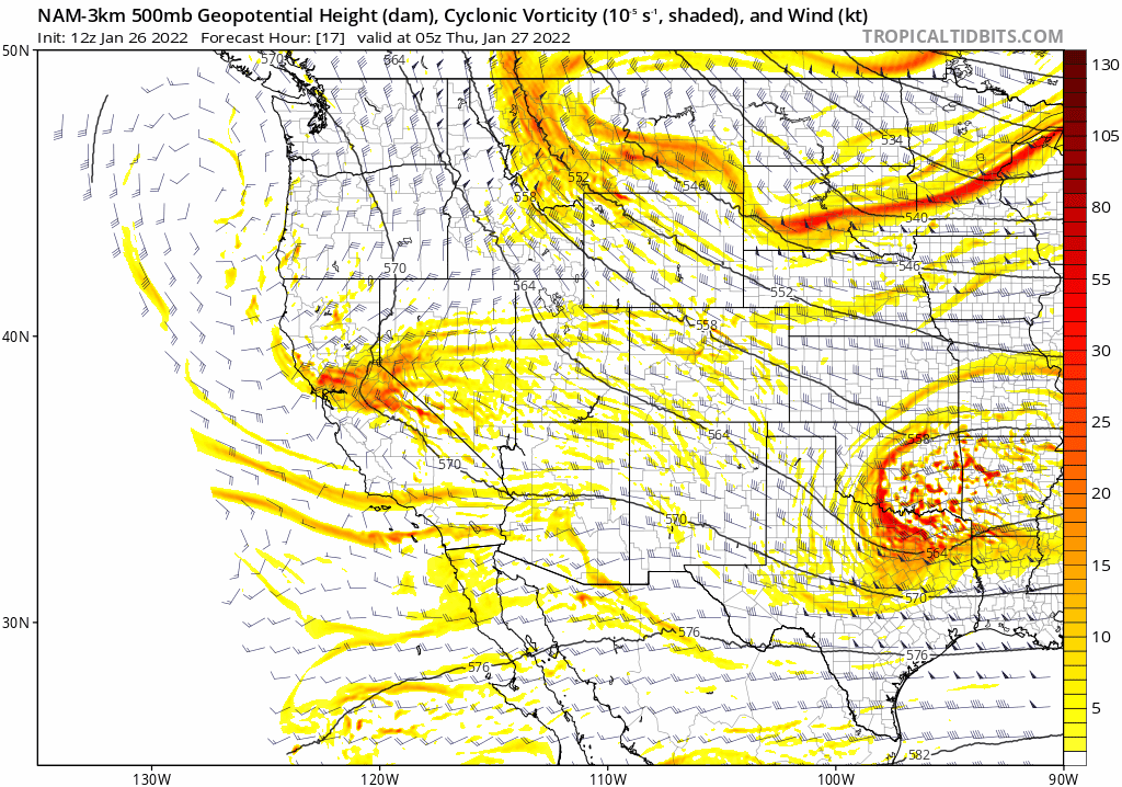
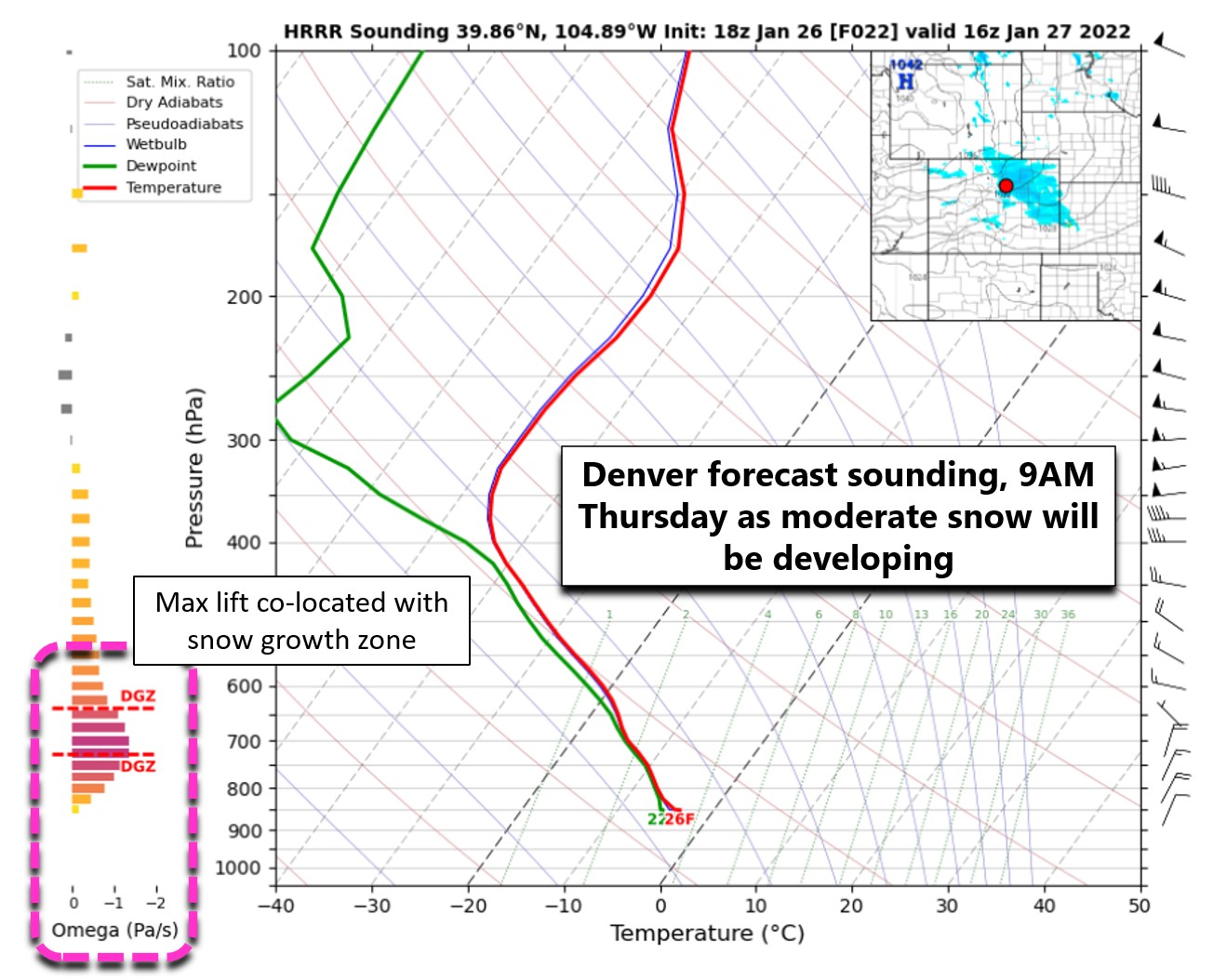
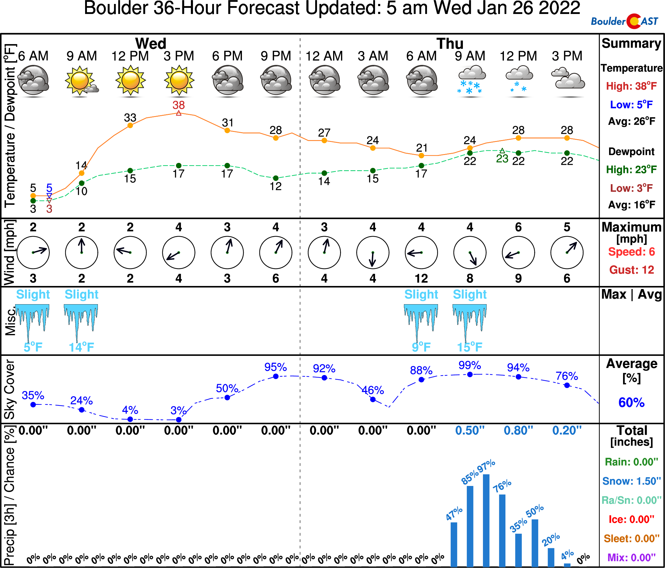
Similar to the last event as well, most of the large-scale energy will stay across central and western Colorado, but some will indeed spill into the Front Range during the early part of the day. The main forcer, once again, will be a cold front drifting south through our area Thursday morning combined with some upslope. This front will focus the winds in such a way to produce a brief burst of moderate snowfall — this mechanism is called frontogenesis. Fortunately, this all appears to align slightly later than the morning commute! Current model timings suggest the more intense snow will begin around 8:00 or 9:00AM Thursday in Boulder and Denver and will last for a few hours. This timing may shift a tad, so the earlier you travel on Thursday the better!
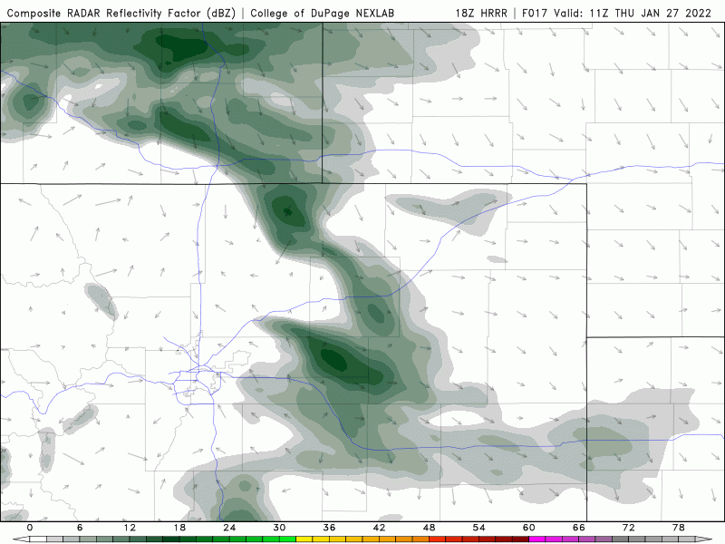
HRRR model-simulated radar animation for Thursday showing frontogenesis spawning moderate snow right over the Denver area
Snowfall this time around won’t be as intense as what we saw on Tuesday, but this system could still support a brief period where snowfall rates get close to 1″ per hour. This will be enough for roadways to become slick and snowy across the entire area. Expect a slightly less impactful outcome than what transpired for travel earlier in the week, but there will still be plenty of accidents and slowdown.
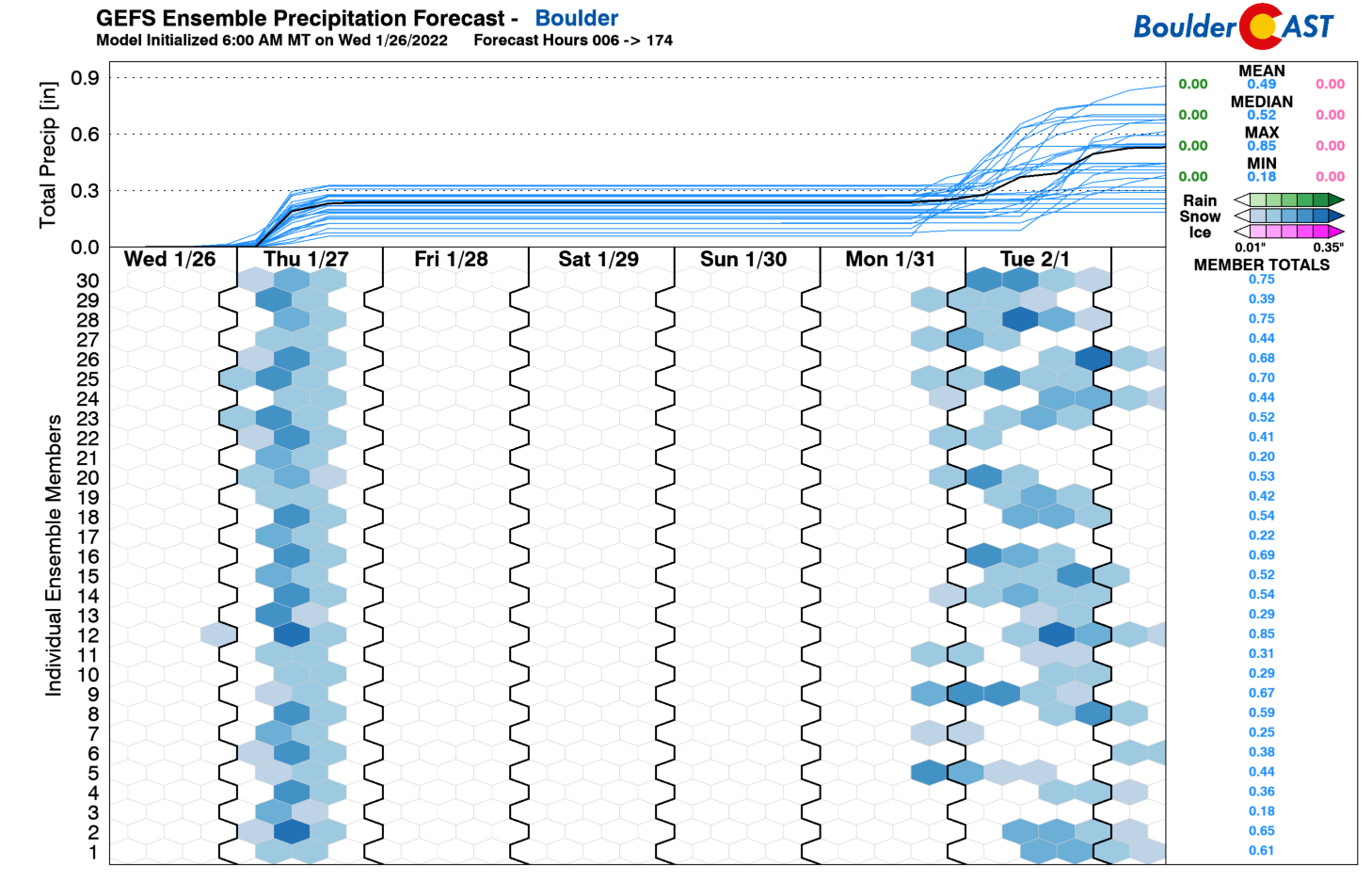
There is decent agreement right now between the Euro model and GFS model (shown below) that both Boulder and Denver will quickly pick up around 0.25″ of liquid from this event on Thursday.
The ensembles are all fairly well-clustered as well giving higher confidence in the amount of moisture headed our way. This also shows our next potential snowfall event to kick off the month of February. No point in discussing that just yet.
One minor difference for this event will be colder overall temperatures. Models are forecasting that the maximum frontal lift and upslope will overlap with temperatures aloft cold enough to support very fluffy snow. This should help boost the snow potential with this event to some degree, counteracting the fact that the system has less overall moisture to work with. The storm earlier this week produced 5.4″ of snowfall in Boulder containing 0.32″ of liquid — snow with a ~17:1 snow ratio. Thursday’s snow ratio should be similar if not a tad higher than this.
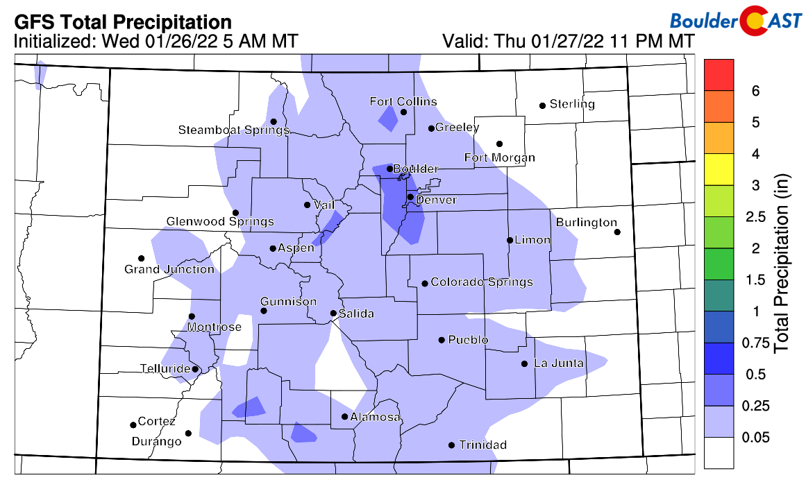
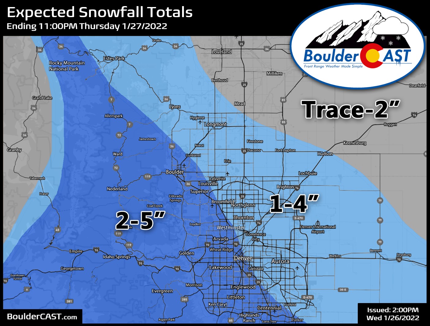
Our snowfall forecast map for Thursday’s snow event is shown below. Generally we’re expecting a broad brush of 2 to 5″ for the Denver-Boulder area, with lower totals north and east. The Foothills could close in on 5″ aided by deep though fairly weak upslope.
As quickly as the snow ramps up it will wind down by early afternoon as the front exits into southeast Colorado. Skies will turn at least partly sunny before sunset and then fully clear out for sure Thursday night paving the way for a warmer and sunny end to the week. Dry and mild weather is expected through Monday as a big ol’ ridge moves through offering up tranquility to close out the month.
Get BoulderCAST updates delivered to your inbox:
Help support our team of Front Range weather bloggers by joining BoulderCAST Premium. We talk Boulder and Denver weather every single day. Sign up now to get access to our daily forecast discussions each morning, complete six-day skiing and hiking forecasts powered by machine learning, first-class access to all our Colorado-centric high-resolution weather graphics, bonus storm updates and much more! Or not, we just appreciate your readership!
Enjoy our content? Give it a share!


You must be logged in to post a comment.