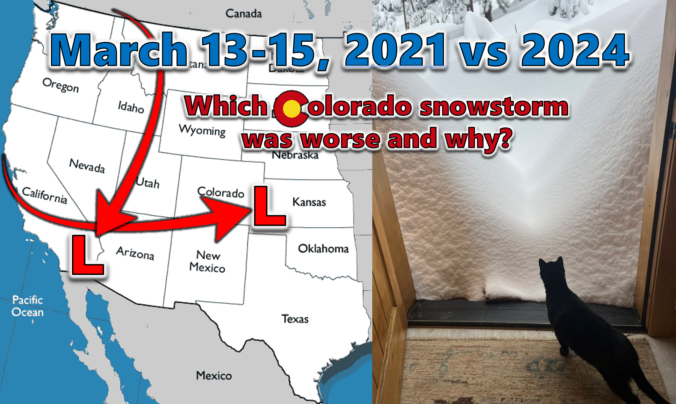
Last week’s dumping of wet snow in the Front Range occurred three years to the day after our most recent significant snowstorm back in March of 2021. We do a comparative analysis between these two epic mid-March snowstorms, examining their distinct storm tracks, the meteorological factors contributing to their varied snowfall production, and discuss their differing forecast hype. We also explore their respective snow totals and distribution across the Denver Metro area, including a detailed account of how these two snowstorms were able to make Front Range history exactly three years apart despite being so fundamentally different.

Go Premium, get all the perks.
Daily Forecast Updates
Get our daily forecast discussion every morning delivered to your inbox.
All Our Model Data
Access to all our Colorado-centric high-resolution weather model graphics. Seriously — every one!
Ski & Hiking Forecasts
6-day forecasts for all the Colorado ski resorts, plus more than 120 hiking trails, including every 14er.
Smoke Forecasts
Wildfire smoke concentration predictions up to 72 hours into the future.
Exclusive Content
Weekend outlooks every Thursday, bonus storm updates, historical data and much more!
No Advertisements
Enjoy ad-free viewing on the entire site.
Storm track
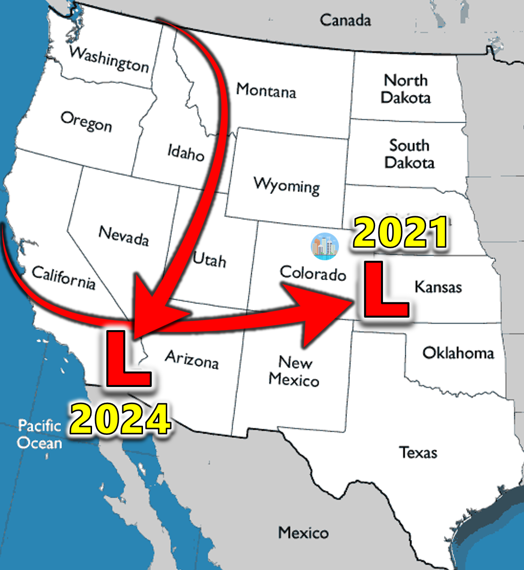
Probably the most crucial difference between these two impressive mid-March snowstorms were their tracks. It was this core element which contributed directly to many of their dissimilarities and ultimately their polarized snowfall production. The March 13-15, 2021 snow event was born in the same manner that many Front Range spring snowstorms are — it came ashore in California, strengthened as it swept across Arizona, and finally arrived into perfect position in southeast Colorado.
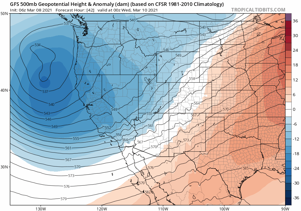
This track is that of a classic Four Corners Low, one that produces deep easterly flow across the entire Front Range and without a doubt is a textbook upslope snow machine, one that chugged at full blast for a solid 36 hours or so.
The 2024 storm couldn’t have had a more different birth from the get-go. It wasn’t a classic southern-track storm at all. In fact, it had origins in British Columbia before diving almost due southward across Nevada on-route to southern California, never coming closer than about 700 miles to Denver.
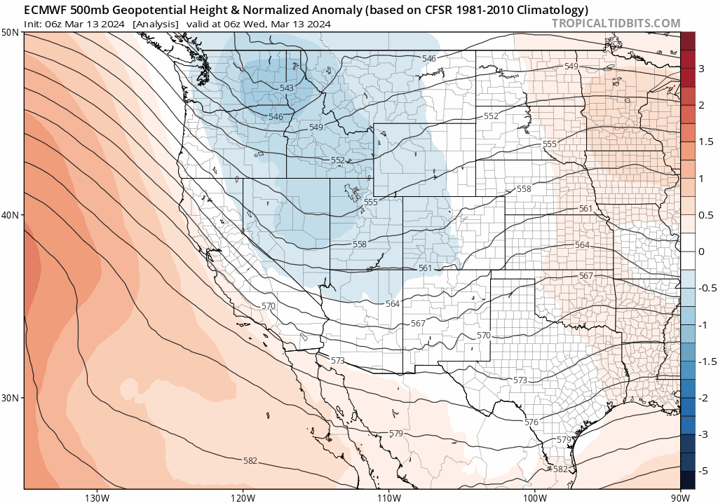
However, the way the low pressure elongated and pinched off from the polar jet stream created a stationary and deep pipeline of upslope winds into the Front Range. There are very few, if any, historical analogs for this type of setup producing such an impactful snowstorm in our area, which is part of the reason the forecast was so challenging in the days leading up to the event last week. The models were very insistent that a huge dump of snow was about to happen — but given how anomalous and rare this setup was — the forecast solutions seemed fantastical at times, even to meteorologists. We definitely remember having similar feelings leading up to the great 2013 Colorado Flood, an event which was even further outside climatology and may not recur in our area for another several hundred years…
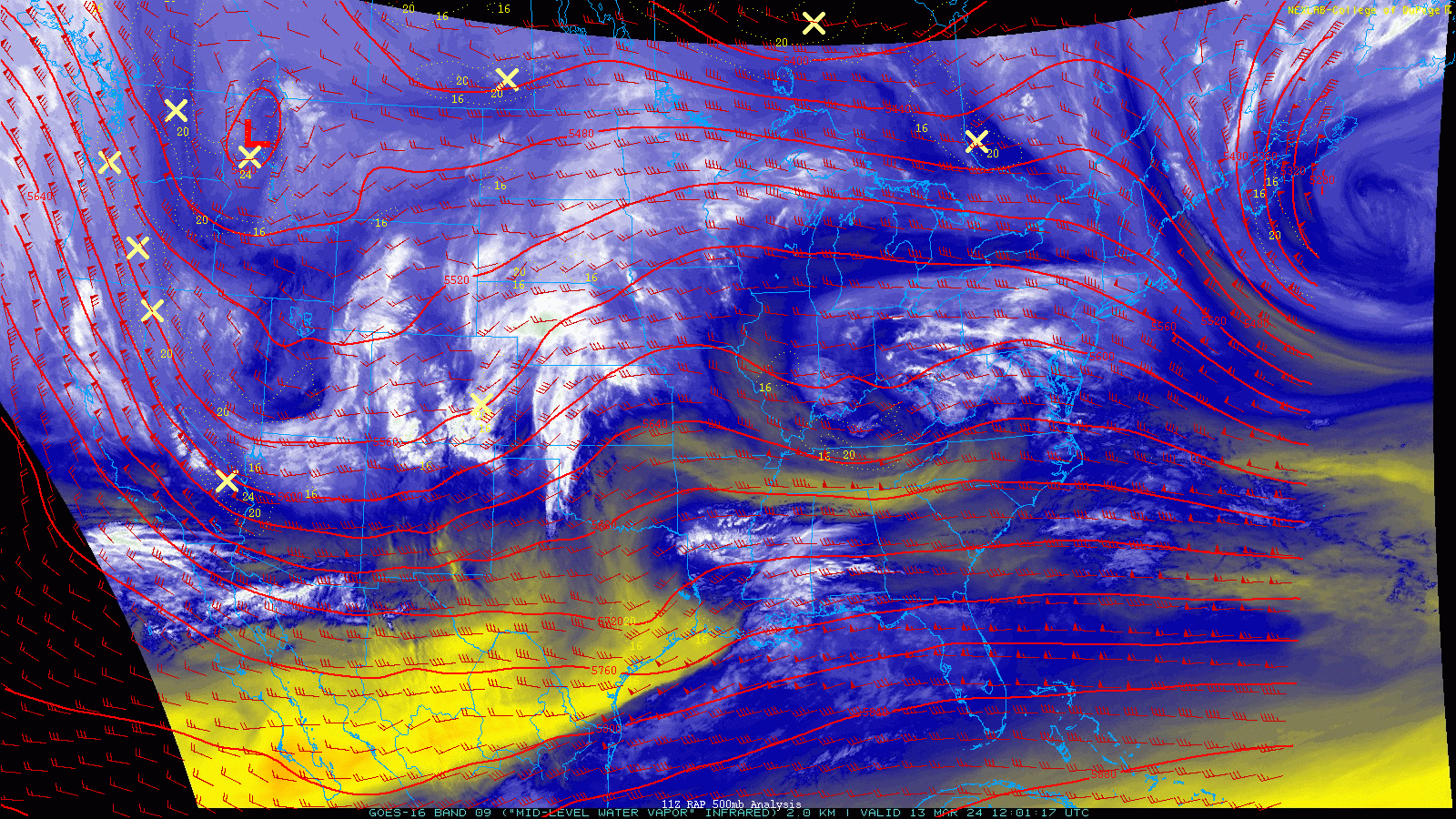
Just take a gander at the two storm tracks on the same map!
Forecast Hype
The hype train leading up the March 2021 snowstorm was unrivaled in recent times, exceeding even the great March 13, 2019 Colorado Bomb Cyclone Blizzard. Some models were consistently showing 3 to 6 feet snow in the Denver area a week in advance of the snowflakes . This fringe model output caught the media’s attention and was subsequently passed along to the readers and viewers, putting the Denver Metro’s public in all-out panic mode. There wasn’t a single loaf of bread, jug of milk, or roll of toilet paper to be found a full three days before the snow began! Our team worked tirelessly for more than a week, putting out in-depth lengthy analysis and discussions every single day leading up to, during, and after the storm. However, a combination of the system slowing down from initial forecast timelines and a narrow but poorly-placed dry slot near the onset of the event caused a lot of initial backlash and anger towards local weather forecasters — with the public calling for the heads of their favorite Twitter weather personalities! As we’ll discuss soon, the 2021 storm eventually delivered the goods in the end — a lot of apologies were dished out to the weather community in the days to follow.

While the March 2024 storm was hyped to some degree, it definitely was more low key than 2021. Model projections weren’t as wild as they were three years ago. There’s a big difference between early forecasts for 6-18″ of snow (2024) and that of 2-5 feet (2021, misguided preliminary forecasts from some outlets/models).
Snow Totals & Distribution
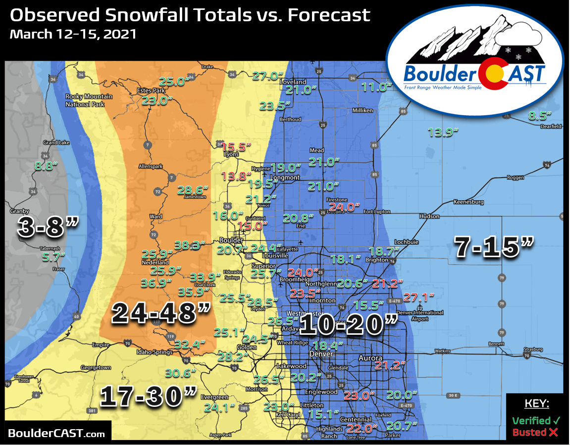
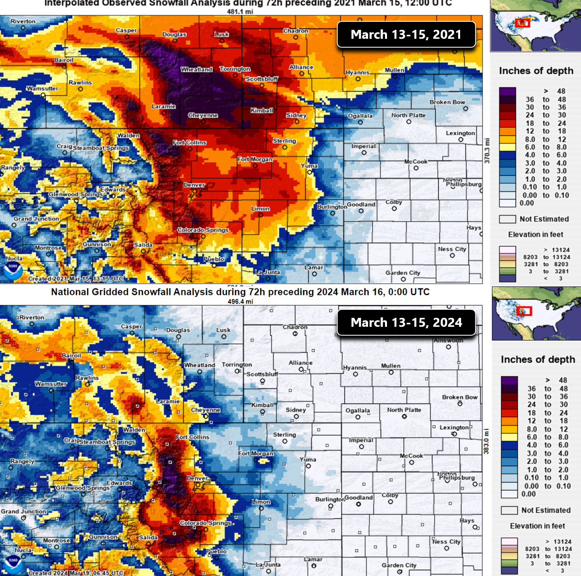
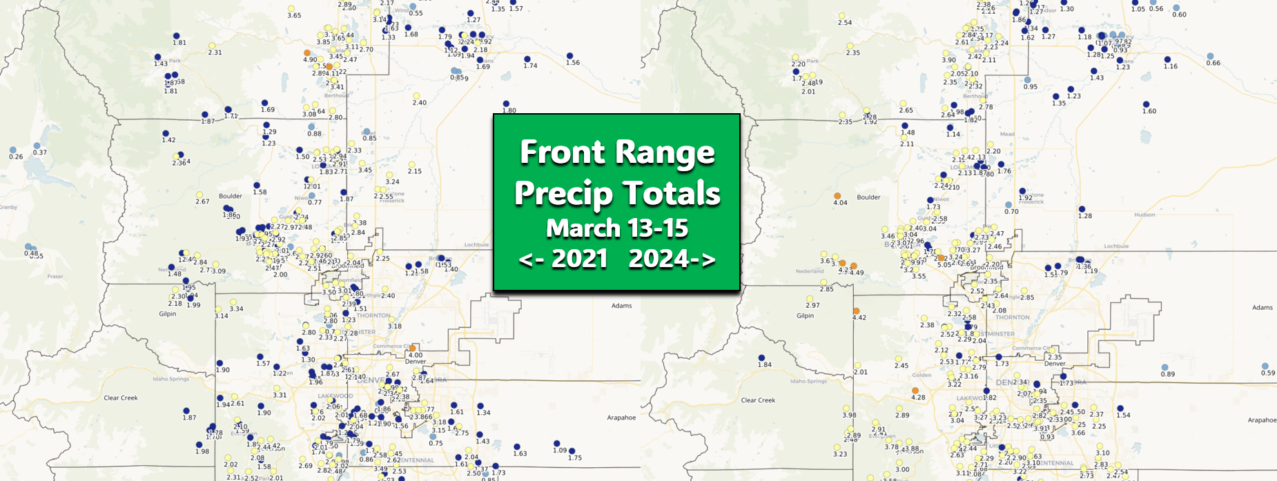
Depending on your exact location, you may have varying opinions on which storm was more extreme and disruptive. That’s because these two produced rather different accumulation distributions in the Metro area. First, here’s a look at the totals from 2021 below. The observed snow amounts are the red and green numbers overlaid onto our forecast map shaded in the background. With few exceptions, almost the entire Front Range landed between 18″ and 36″ of snow — just an incredible dump of white stuff for everyone! The highest totals were in the Foothills, but not really by a huge margin — with most higher-terrain locations landing between 23 and 36″. Officially, the 2021 storm dumped 27.1″ on Denver International Airport (!) making it Denver’s 4th largest all-time snowstorm, with a respectable but lesser 20.7″ falling in Boulder. Also note the almost perfect east-west gradient in our snowfall forecast map, our response to the due easterly upslope flow that defined this storm as the big, sloth-like parent low migrated slowly across southern Colorado.
Now let’s check the totals from 2024! First off, Foothills snow amounts were notably higher from this 2024 event, with most locations landing north of 32″ and in some cases over 50″. Across the lower elevations, totals from this event were much more varied. There were low-end reports as measly as 6″ near DIA, but up to 30″ close to Golden. Also note that our forecast map had an expected gradient oriented more northeast-to-southwest, a result of the upslope flow predominantly coming from the northeast with this storm, rather than due east as it was three years prior in 2021.
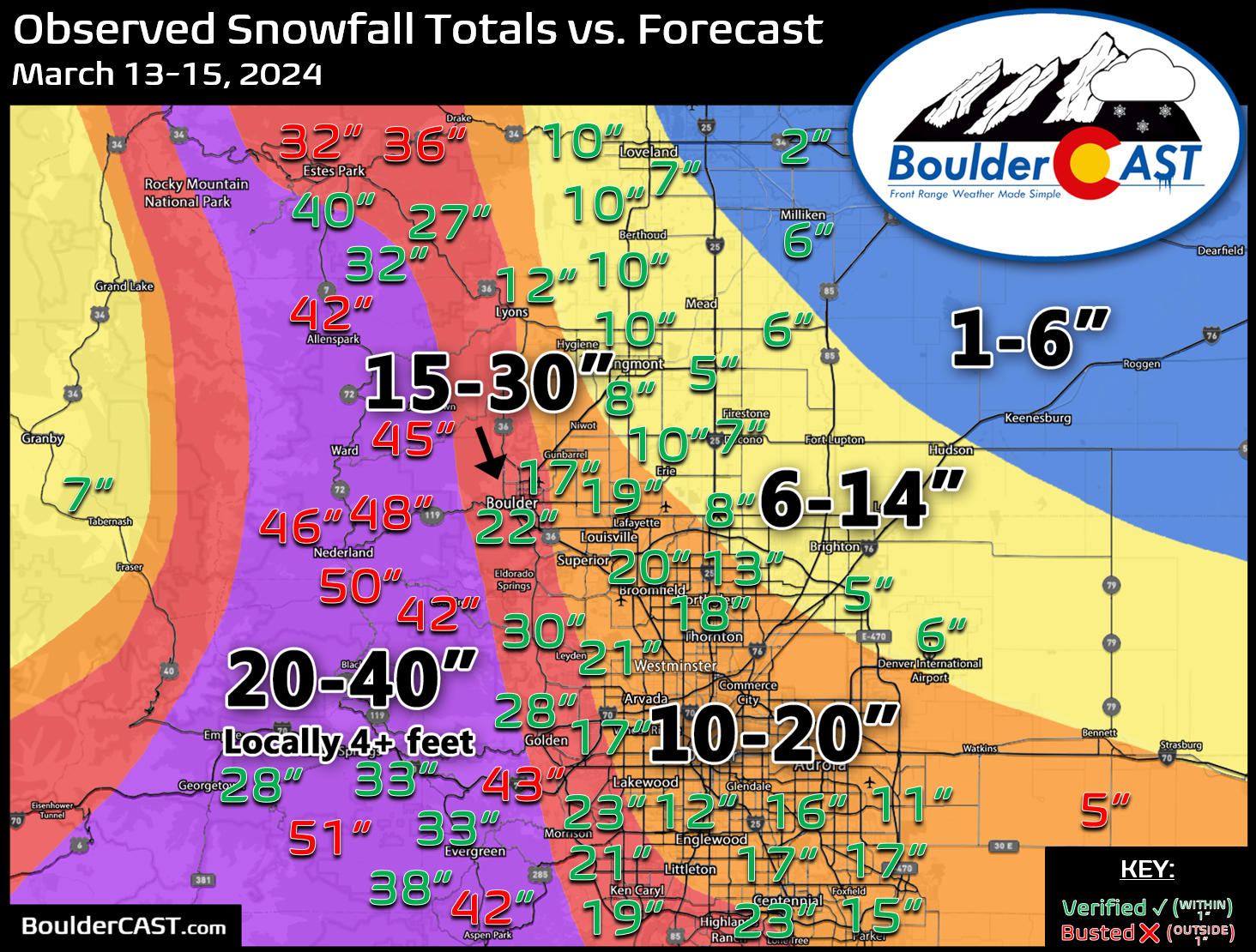
Comparing the observed snow total analysis from the broader region, it is clear that 2021 was the bigger and badder snow storm, with more than a foot falling over a huge area from Colorado Springs well north into Wyoming and east into Nebraska and South Dakota. While 2024 was a crazy storm as well in many regards, it was much more localized to just the Front Range. Within a few miles east of I-25 there was barely any snow!
The graphic below shows the quantified difference in snow totals between the two events (2024 totals minus 2021 totals). Green values indicate 2024 had more snow at that location, while red indicates 2021 instead produced more snow. Basically most of the Denver area was crushed harder in 2021, whereas the Foothills mostly saw significantly more snow in 2024. Locations right along the base of the Foothills like Lyons, Boulder and Golden basically had similar outcomes both years with less than 4″ of difference between the two events either direction.
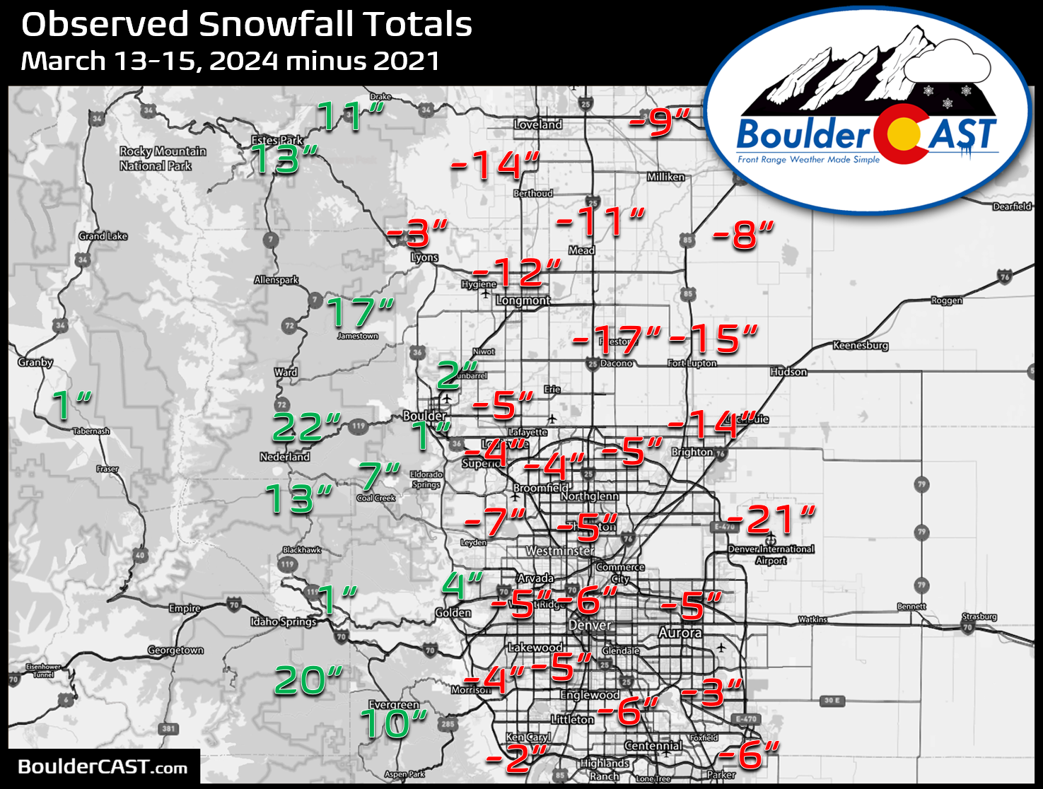
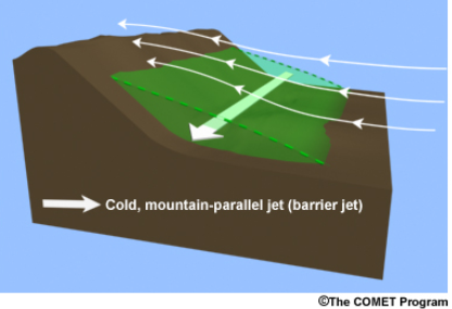
Why was the distribution between 2024 and 2021 so different? The main reason was that the upslope flow in 2021 was stronger, due easterly and persisted longer — all of these factors contributed to the formation of a pronounced barrier jet. The huge east-west extent of the heavy snow in 2021 was indicative of a barrier jet developing along the western Metro area. When strong easterly upslope flow slams into the terrain for an extended period, it eventually can turn southward and intensify causing a jet of cold air in the very lower atmosphere parallel to the Foothills. This cold, dense dome of air acts as an obstruction itself causing added lift which stretches well away from the terrain. The jet also drew in colder air from the north helping for better accumulation across the lower elevations, even in the middle of the day with the mid-March sun beating down through the clouds.
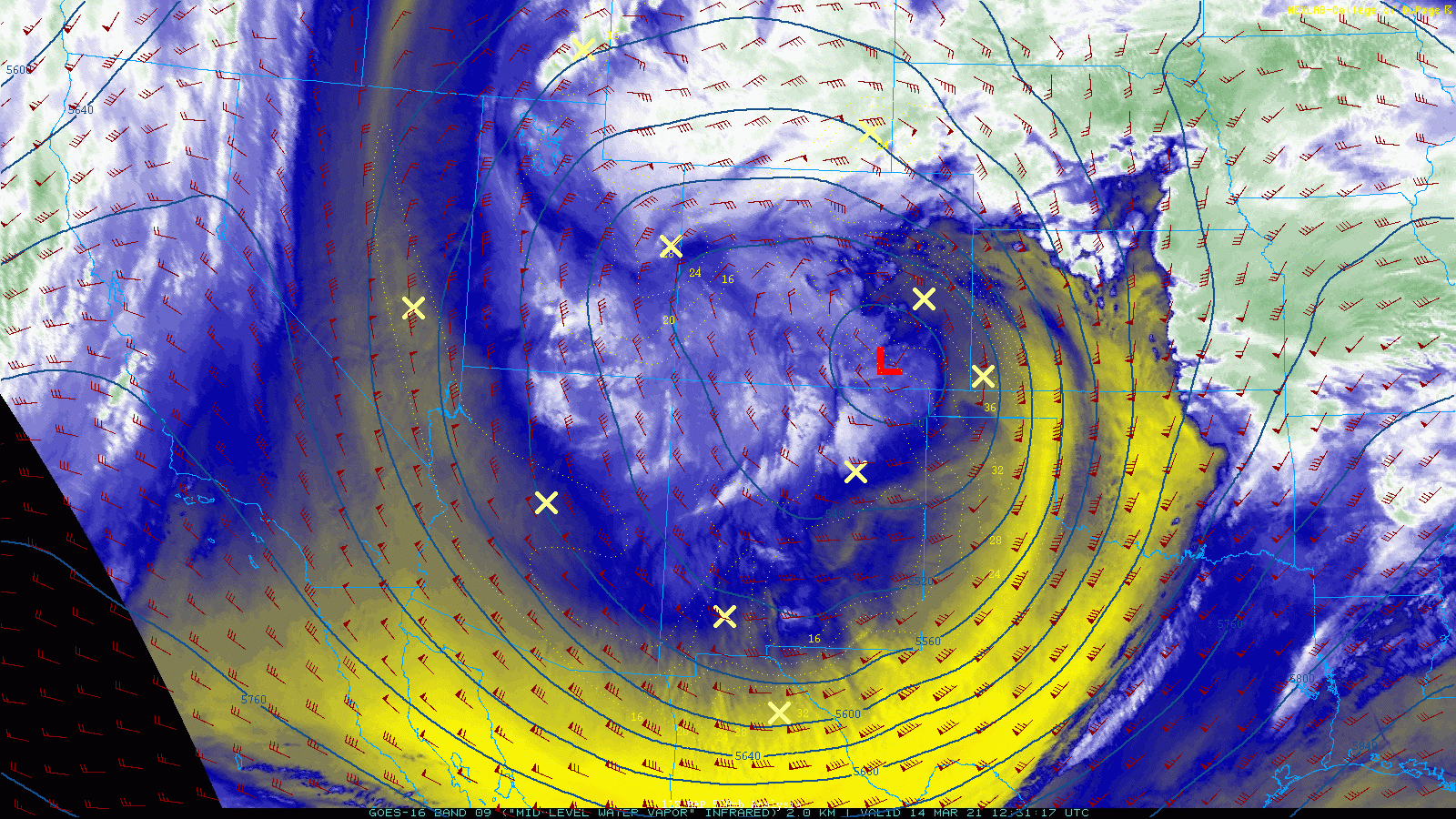
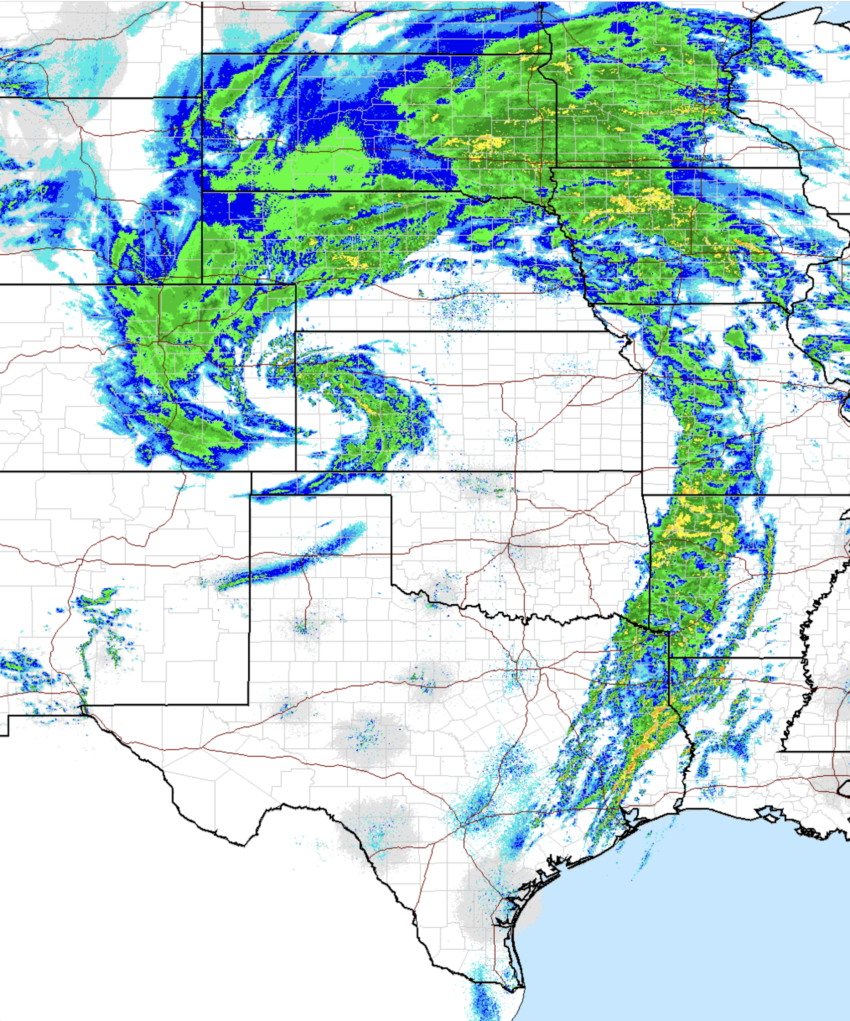
Check out the magnificent radar animation from March 15, 2021 below. Extremely heavy snowfall was hammering the entire Front Range, even areas well east of I-25, thanks to the barrier jet. In fact, the heaviest snowfall rates at times were indeed out along I-25, not in the Foothills, which is the primary reason totals were more “even-steven” across the region back in 2021. Winds for the 2024 event were weaker and not well-aligned to form a barrier jet and thus the heaviest snow much of the time remained closer to the Foothills. Temperatures also played more of a key factor in 2024, with many spots staying above freezing throughout the entire event leading to significant melting across the lower elevations (sorry Longmont!). At the same time, the Foothills were entirely below freezing which made for a larger dump in the higher terrain.
Radar animation from March 15, 2021 as intense easterly flow pounded the Front Range, with heavy snow extended well away from the terrain due to a barrier jet
Historical Context, Aftermath, & ENSO
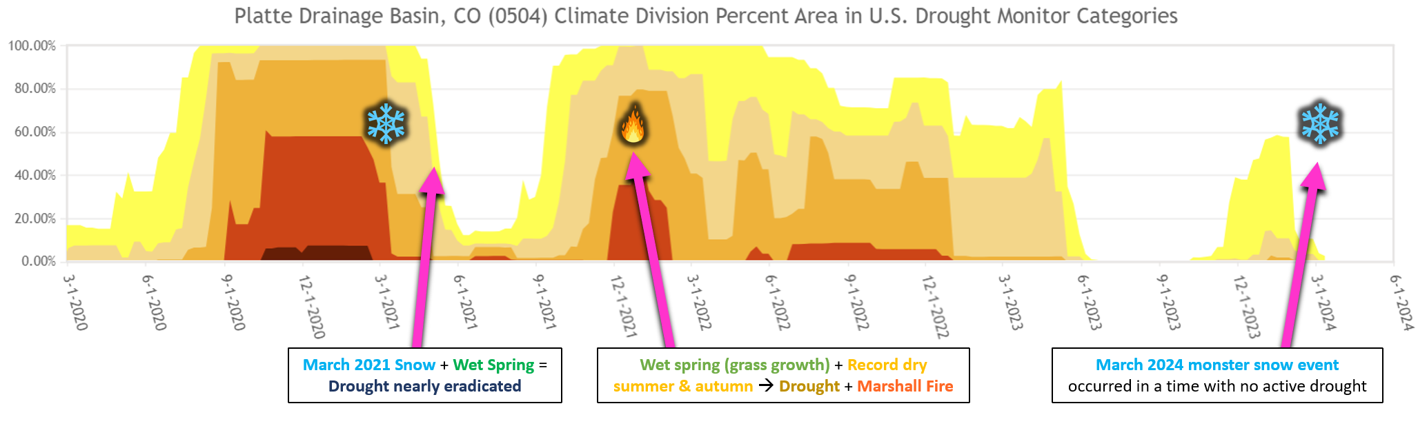
In the end, both storms produced more than 20″ of snow in Boulder and are exclusive members of our Top 16 Largest Snowstorms list. However, one differentiator was 2021 being a unicorn example of such a massive dump of snow occurring during an active La Niña in the tropical Pacific Ocean. This just doesn’t happen, though the southern-track of the March 2021 snowstorm was very much “El Niño” in spirit!
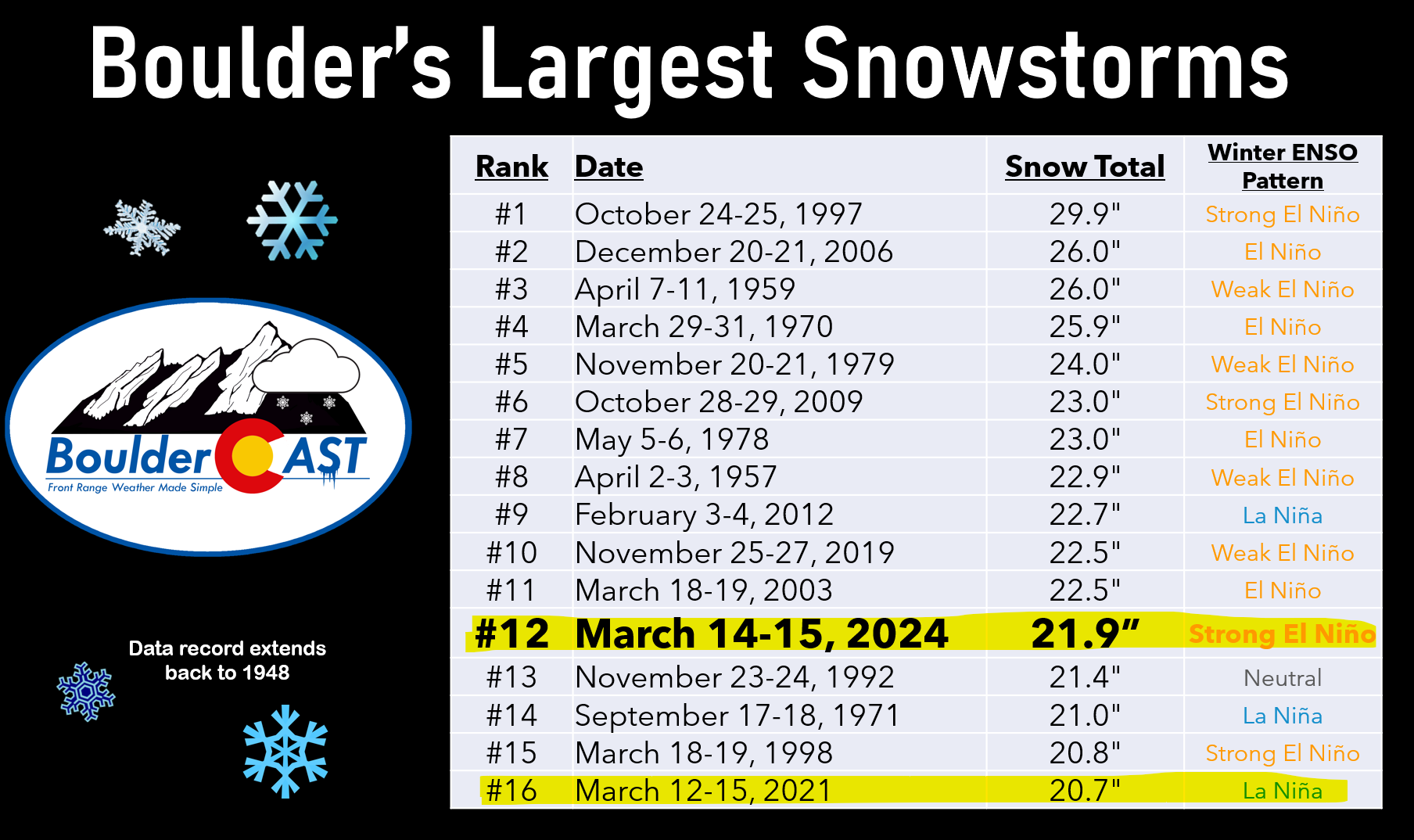
Big La Niña snowstorms are a rare breed for the Front Range — snowstorm counts for Boulder are shown below (data back to ~1950), clearly being dominated by El Niño:
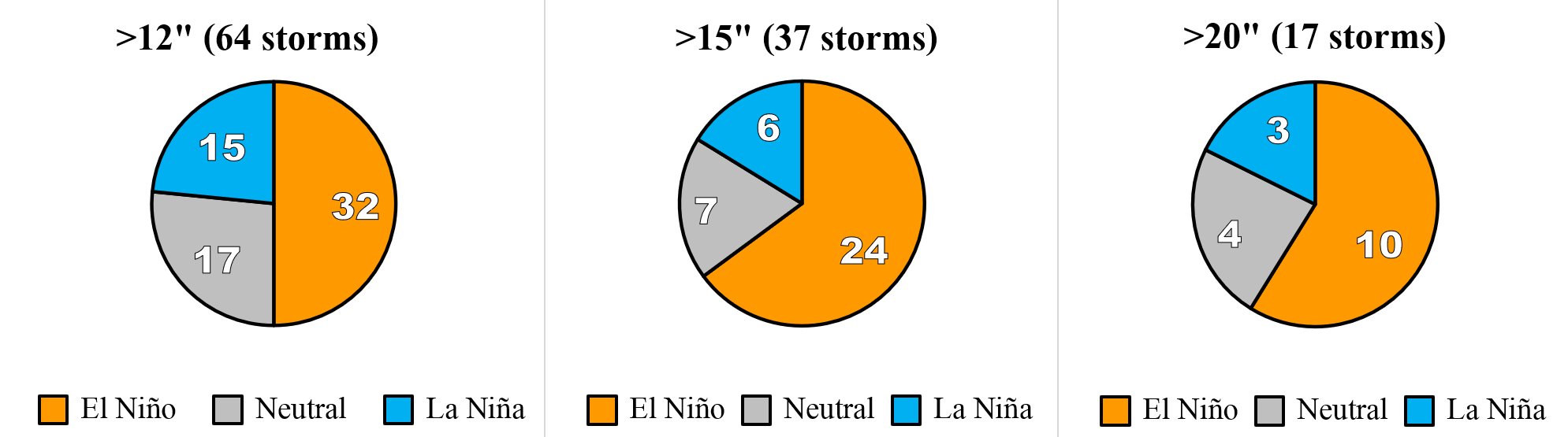
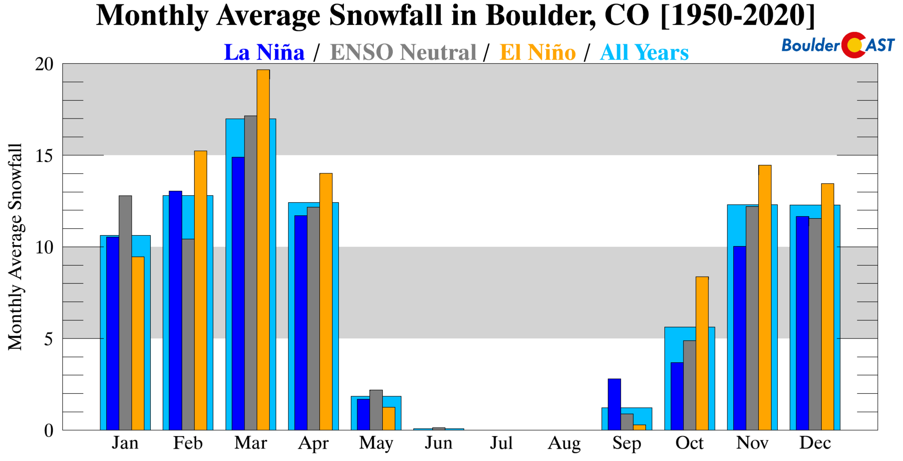
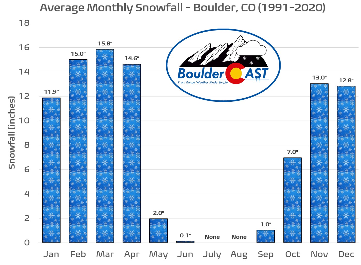
With only a few exceptions, most months where snow is possible in Boulder have average snowfall amounts skewing heavily towards El Niño. March is one of the most pronounced in this regard with nearly 5″ more snow (~33%) falling during El Niño compared to La Niña years on average.
In terms of raw moisture (rain + melted snow water), 2024 undeniably (and somewhat surprisingly) takes the cake, with widespread precipitation totals of 2-4″ across most of the Metro area. Only a few unlucky spots received less than 2″! However, back in 2021, most cities received 1.5-2.5″ of precipitation, with a few 3″ totals in the Foothills.
The hydrological situation across northeast Colorado was much different back in 2021 than it is now. Despite putting down less moisture, the 2021 snowstorm fell onto extremely parched soil with 100% drought coverage in the Platte River Basin (South + North Platte) at the time. The deluge of wet snow put a huge dent in the ongoing drought, with the subsequent wetter-than-normal spring months nearly eradicating the drought by June 2021. We all know what happened in the months that followed, though. A historically dry summer and autumn soon transpired in the lead up to the Marshall Fire, the most destructive wildland-urban blaze in state history. Ironically the Marshall Fire was able to become so ruinous due to the explosion of prairie grass growth originally kick started nine months prior by the mid-March snowstorm.
Interestingly, if you go back exactly another two years to March 13, 2019 — we could have brought another same-date March snowstorm into this discussion — the infamous 2019 Colorado Bomb Cyclone! That storm was hyped to oblivion as well, but ultimately was more wind than snow for most of the Metro area. Hurricane force winds briefly rocked eastern Colorado with blizzard conditions, but it only produced about 3-6″ of snow in Boulder and Denver.
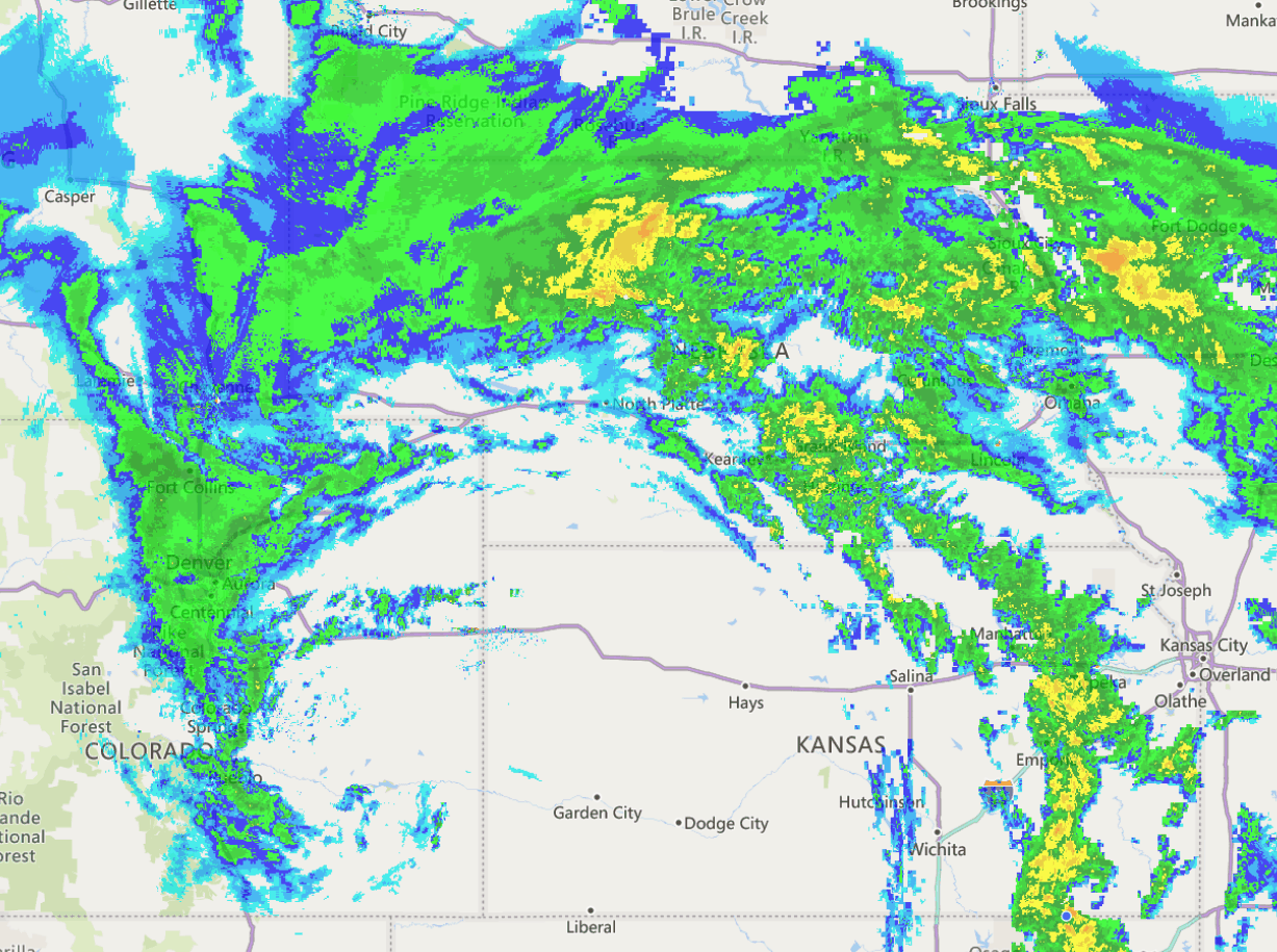
March 13, 2019 radar image as the powerful low pressure crossed over from Colorado into Kansas
At this point, you may be wondering why Mother Nature tends to go hog-wild with winter weather between March 13th and 15th. Though March is our snowiest month of the year (yup!), the recent “same day” snowstorms are more of a coincidence than anything. However, if yet another huge wallop of snow unfolds on March 13th in 2025 — we might just have to take a closer look into this as a new and very real predictive parameter!
Read our in-depth recaps of all three winter storms discussed in this post below.
March 13, 2019:
March 13-15, 2021:
March 13-15, 2024:
Feature image photo by Julie Garrigue, name of pictured kitty unknown.
Go Premium, get all the perks.
Daily Forecast Updates
Get our daily forecast discussion every morning delivered to your inbox.
All Our Model Data
Access to all our Colorado-centric high-resolution weather model graphics. Seriously — every one!
Ski & Hiking Forecasts
6-day forecasts for all the Colorado ski resorts, plus more than 120 hiking trails, including every 14er.
Smoke Forecasts
Wildfire smoke concentration predictions up to 72 hours into the future.
Exclusive Content
Weekend outlooks every Thursday, bonus storm updates, historical data and much more!
No Advertisements
Enjoy ad-free viewing on the entire site.
Spread the word, share Colorado’s crazy weather:


You must be logged in to post a comment.