May has finally snapped the atmosphere out of its months‑long bone dry spell, and the Front Range is making up for lost time fast. A destructive early‑May snow event, followed by a second, well‑timed upslope system just ten days later, has pushed Boulder’s May precipitation total beyond everything we managed to scrape together through fall, winter, and early spring combined. We dig into what triggered the pattern reversal, how much moisture different parts of the region have banked, what this burst of wet weather actually means for our entrenched drought, and whether the upcoming Memorial Day weekend warm‑up signals a slide back toward a more aggressive drying trend.
What You Need to Know
- 🌧️ May has finally flipped the script, delivering more moisture in two weeks than Boulder saw in the previous seven months combined.
- ❄️ Early‑May snowstorm was a doozy, dropping 11.3″ in Boulder and 2+ feet in the Foothills — the season’s biggest snowstorm caused widespread tree damage and CU’s first-ever closure for falling tree limbs during snow.
- 🌡️ Was that snowstorm a one off? Record warmth followed the snow, with five straight days in the 80s and two new daily record highs set before the next storm arrived.
- 🌦️ Second upslope system reloaded the moisture, adding another 1–2″ of liquid while sparing the lower elevations from snow.
- 🌵 Drought improved but remains severe, with 96% of Colorado still in drought and long-term, West-wide deficits lingering despite localized Front Range relief.
- 🔭 Memorial Day weekend trends warmer and drier, with 70s–80s and a few late-day storms. Lots of dry time.
- ⛈️ More hope on the horizon as additional unsettled weather looms next week. Plus an El Niño‑boosted monsoon summer would favor continued long-term improvement.

Go Premium, get all the perks.
Daily Forecast Updates
Get our daily forecast discussion every morning delivered to your inbox.
All Our Model Data
Access to all our Colorado-centric high-resolution weather model graphics. Seriously — every one!
Ski & Hiking Forecasts
6-day forecasts for all the Colorado ski resorts, plus more than 120 hiking trails, including every 14er.
Smoke Forecasts
Wildfire smoke concentration predictions up to 72 hours into the future.
Exclusive Content
Weekend outlooks every Thursday, bonus storm updates, historical data and much more!
No Advertisements
Enjoy ad-free viewing on the entire site.
From Bone Dry to Drenched
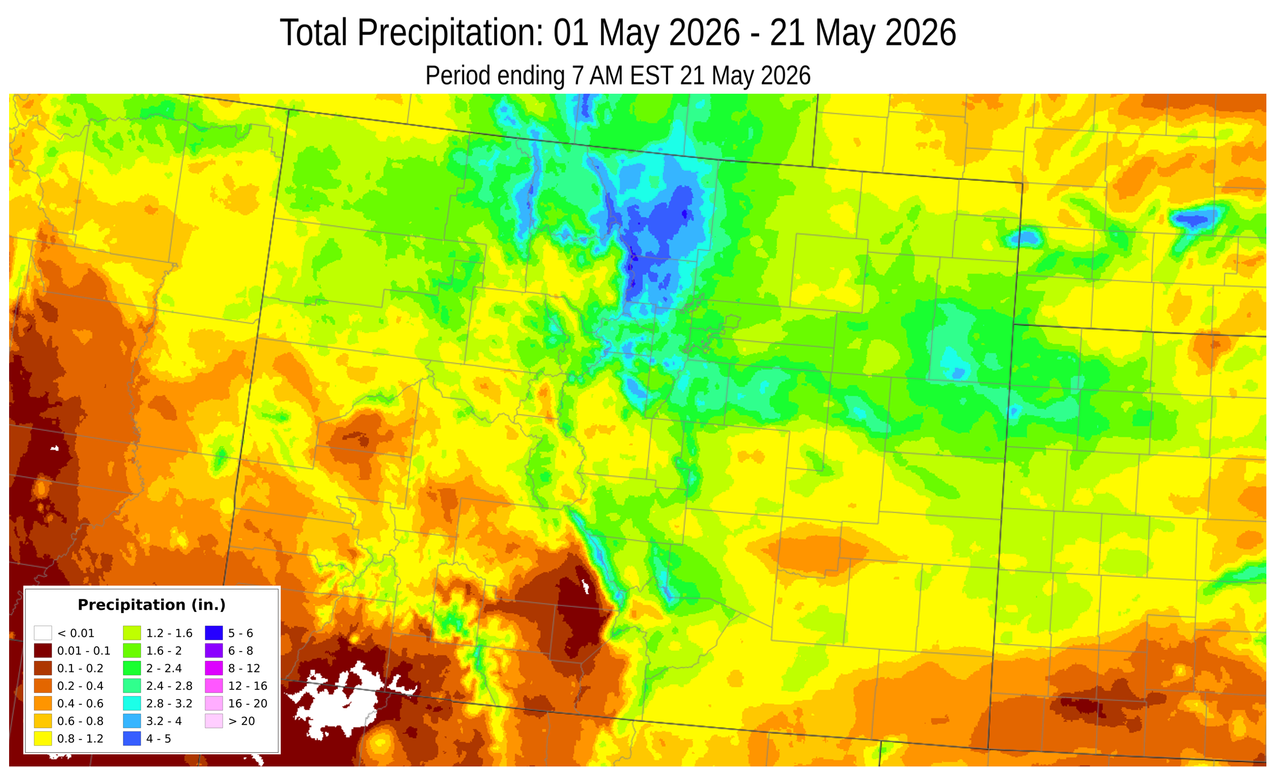
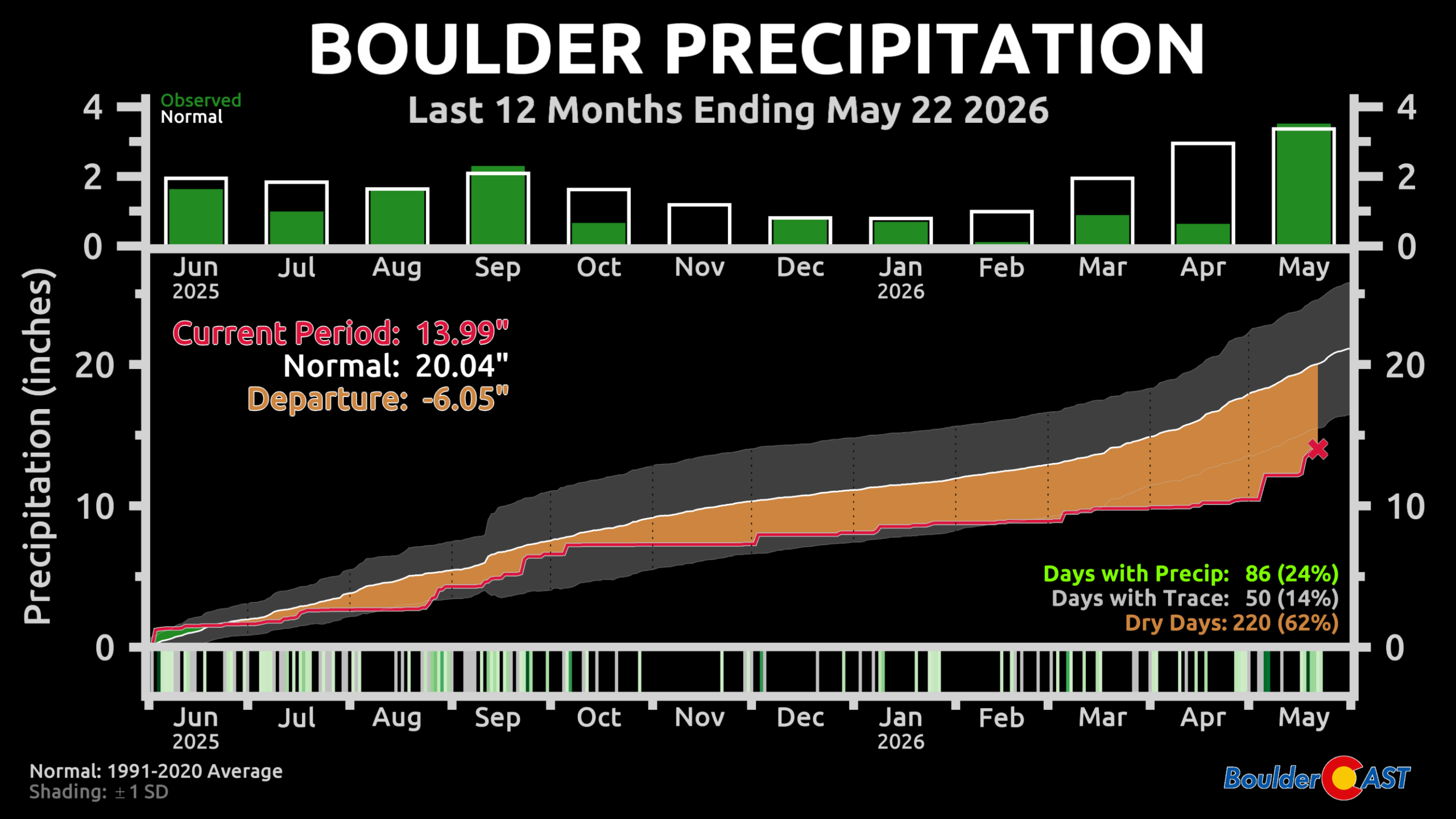
After many long months of bone dry conditions through the autumn, winter and early spring with drought tightening its grasp with each passing day, the Front Range has finally cashed in on some real moisture over the last two weeks in what has been a very soggy (and don’t forget snowy!) month of May so far. Boulder has now logged more precipitation in the last ~2 weeks than in the previous 7 months combined, a staggering statistic that underscores just how anomalous this pattern shift has been.
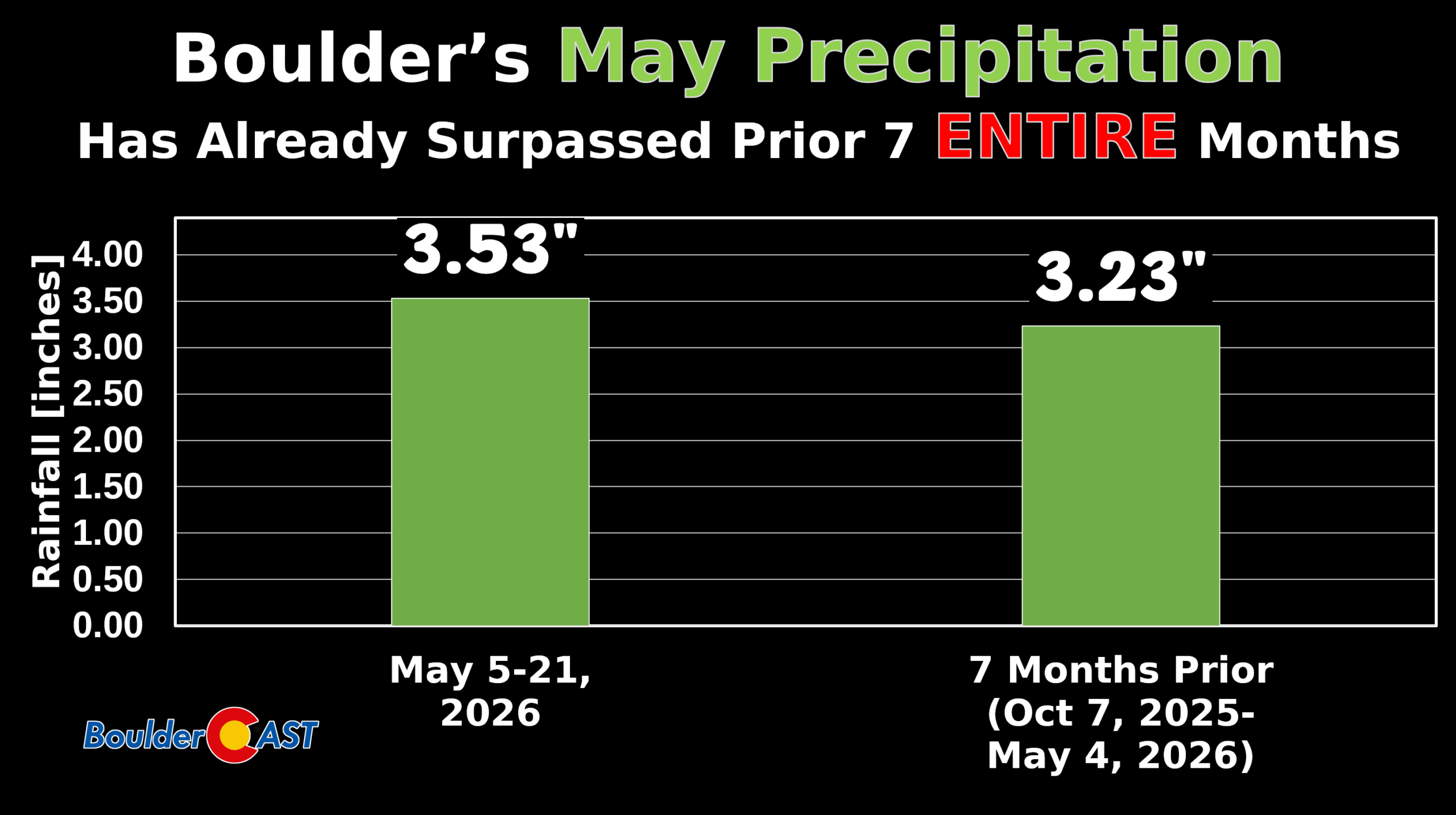
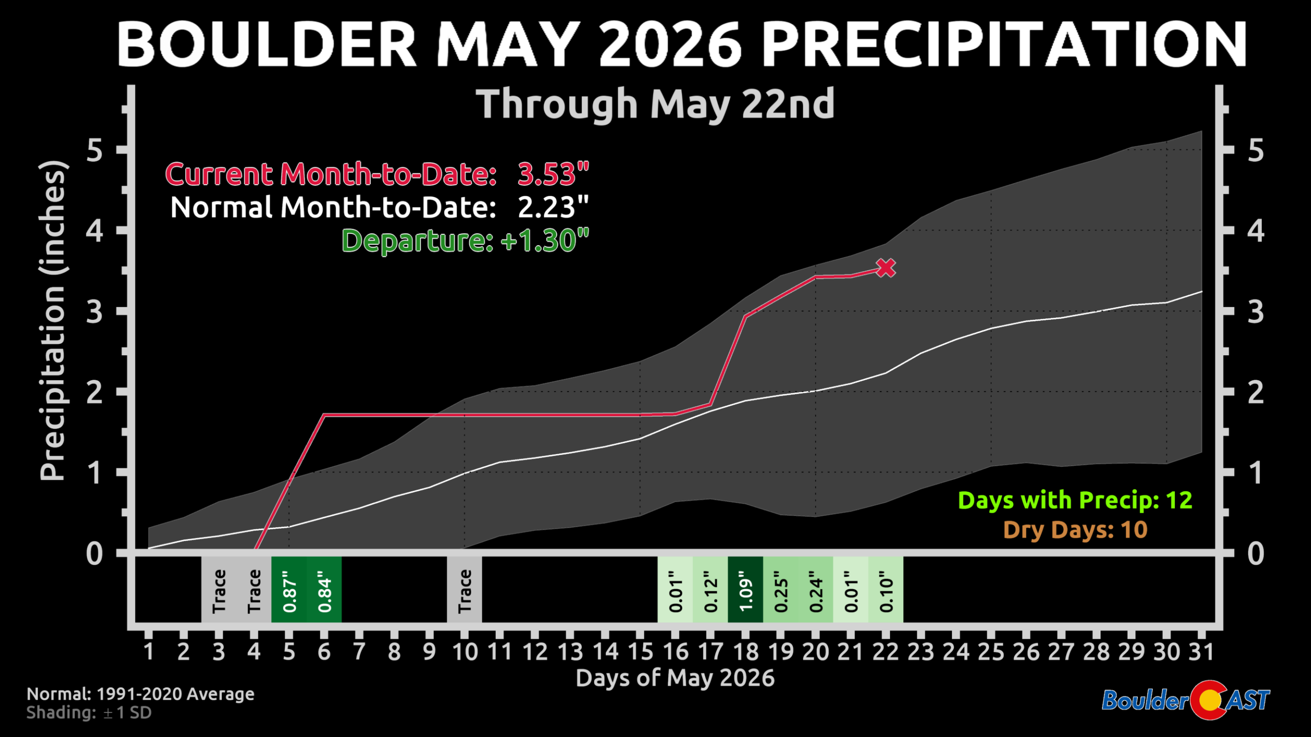
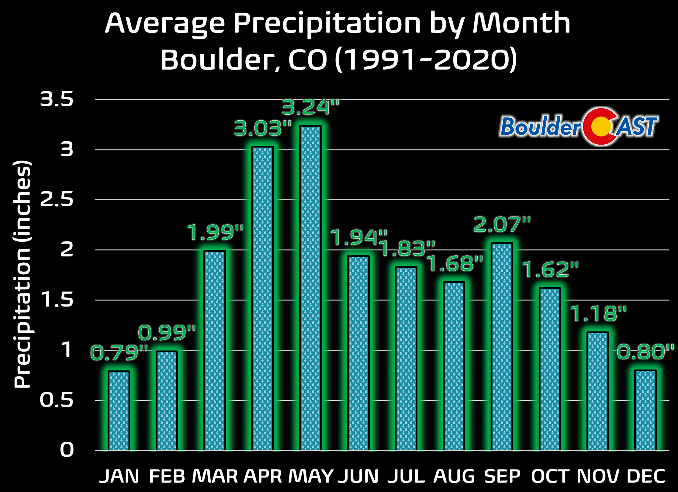
Through just the first 22 days of May, Boulder has tallied 3.53″ of liquid, running about 1.3″ above normal for the month‑to‑date.
The Pattern Break: How We Got Here
The broader shift began in early May when the stubborn ridge that dominated the West all winter — the same ridge responsible for the unprecedented March heatwave and historically poor snowpack — finally buckled. Once that ridge collapsed, the prevailing flow opened the door for a “Perfect Storm” type of setup in the Front Range:
- Cold Canadian air dropping south
- Subtropical jet moisture surging northeast
- A collision zone parked directly over the Front Range
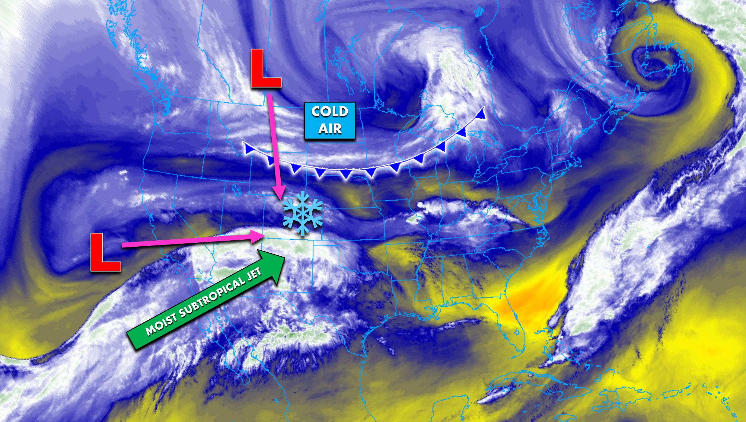
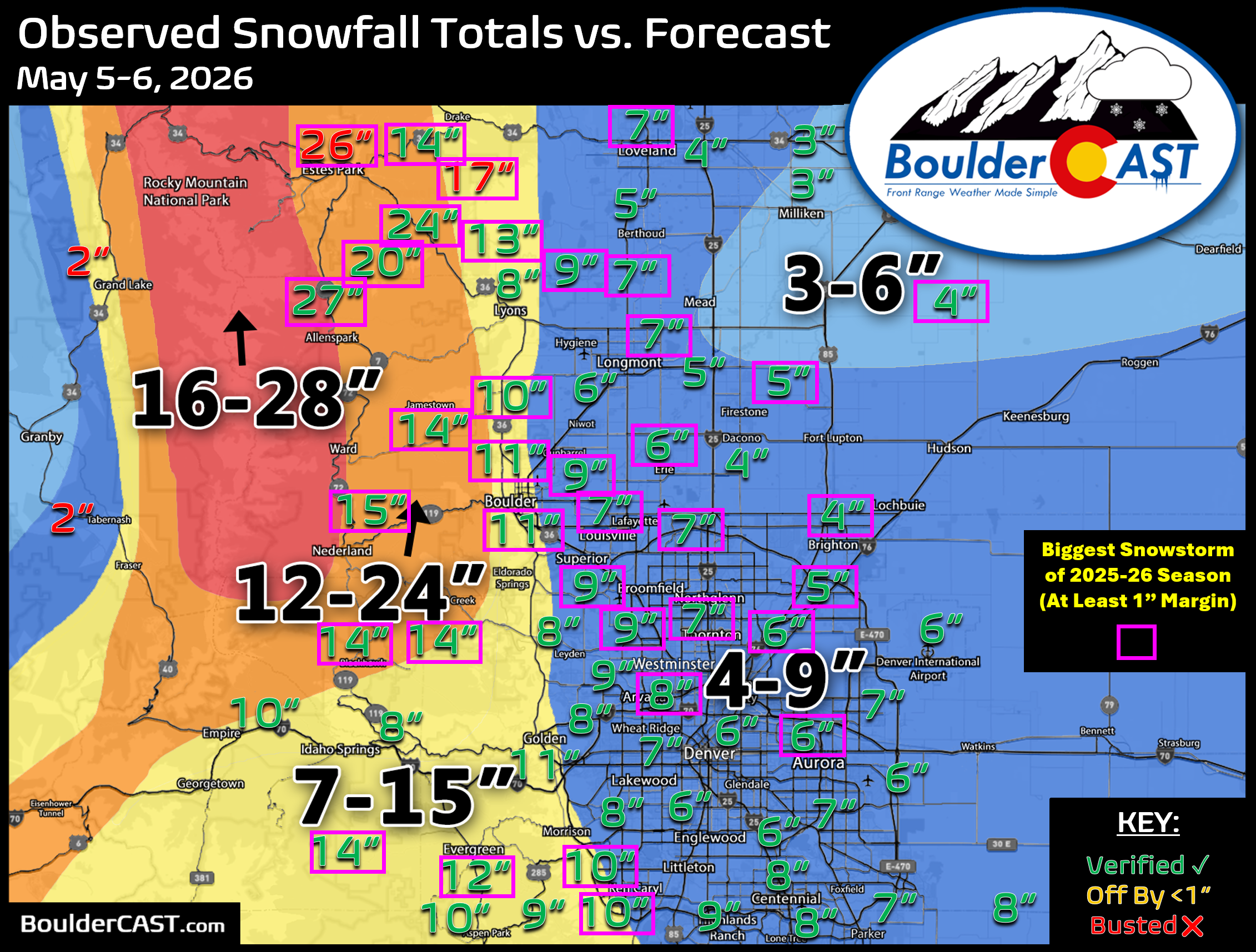
That combination produced the May 5–6 wet‑snow event, which delivered both widespread tree damage and a desperately needed injection of moisture. Boulder recorded 1.71″ of liquid from that storm alone — more than the previous three months combined.
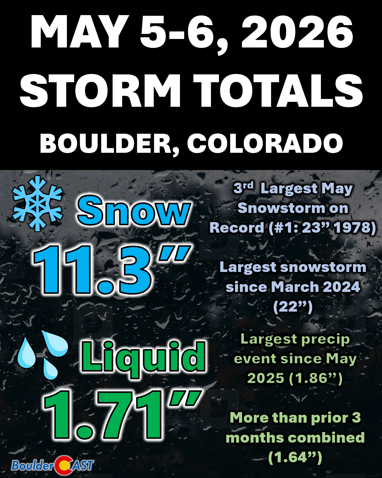
Incredible snow totals over 2 feet occurred in the Foothills of Larimer and Boulder Counties. Estes Park was hit particularly hard at the epicenter of the winter wonderland, which was relatively well-forecasted by the way. For many along the Front Range, this became the largest snowstorm of the entire 2025–26 season, a rare feat for May. Boulder hadn’t seen its biggest snow of the season occur in May since 1978.
The 11.3″ that fell in town was our largest single snow event since March 2024 and, for the first time ever, forced a full closure of CU Boulder’s campus — not for icy roads, but for the extreme hazard of falling limbs. A record-warm spring, which leafed the trees weeks ahead of schedule, primed the city for widespread destruction.
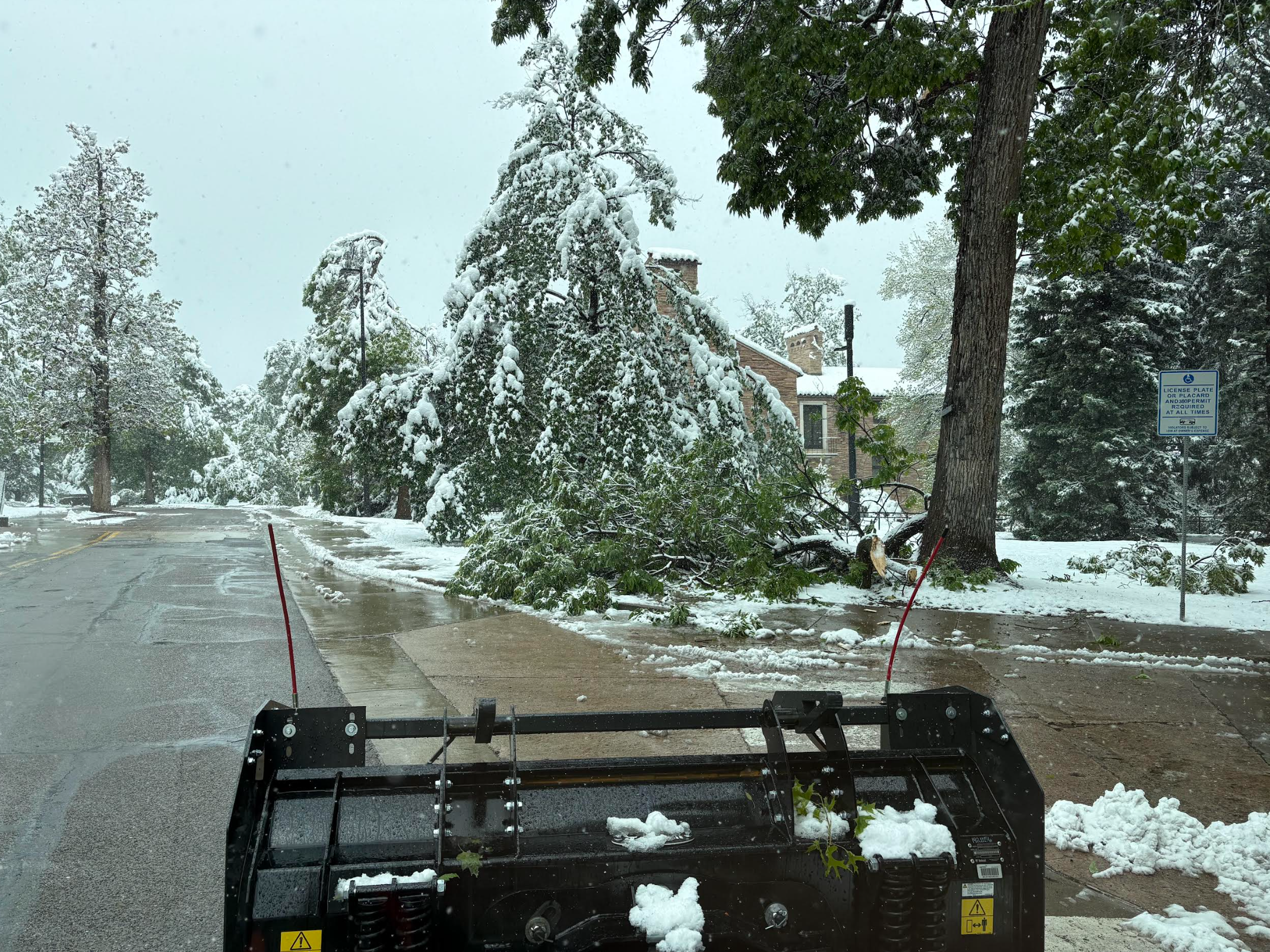
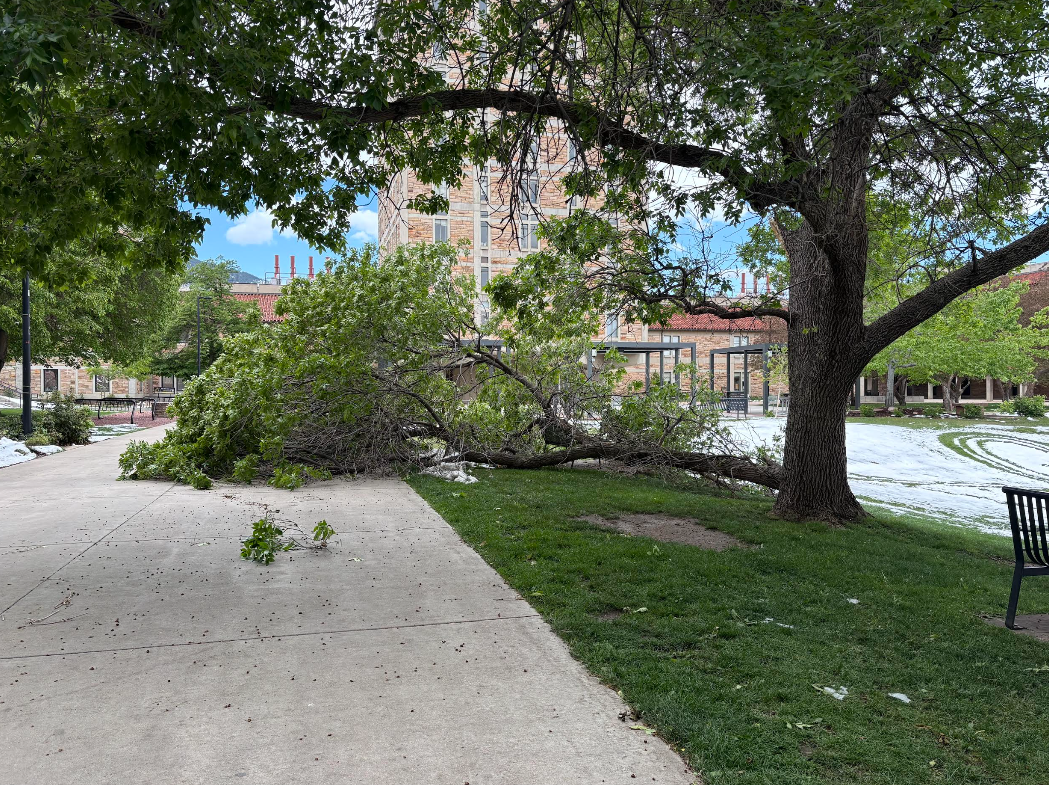
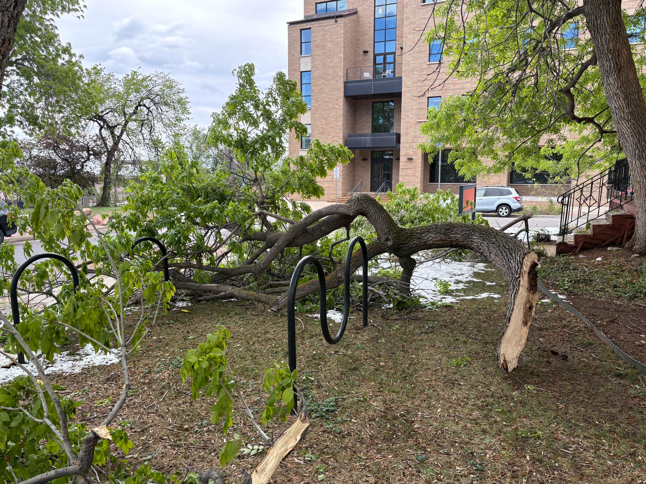
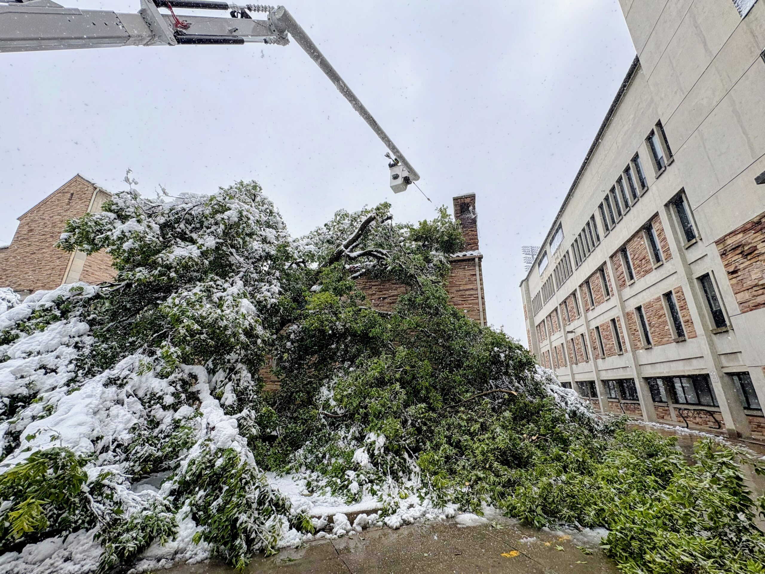
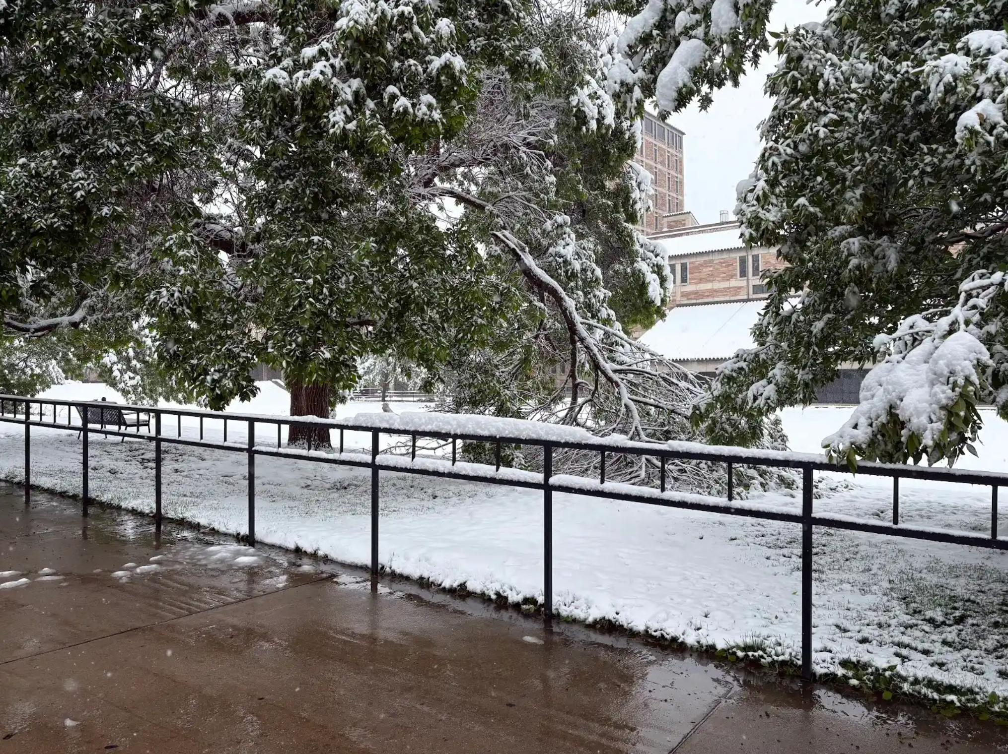
Devastating tree damage across CU Boulder following the May 5-6, 2026 snowstorm | Photos by Ryan Heiland
A Brief Thaw… Then Round Two
That sloppy snow vanished almost as quickly as it arrived as a week of relatively benign and warm weather ensued following the snowstorm. Temperatures soared into the mid to upper 80s for five straight days, two of which set new daily record highs, with Boulder narrowly avoiding its earliest 90° reading on record by the slimmest of margins.
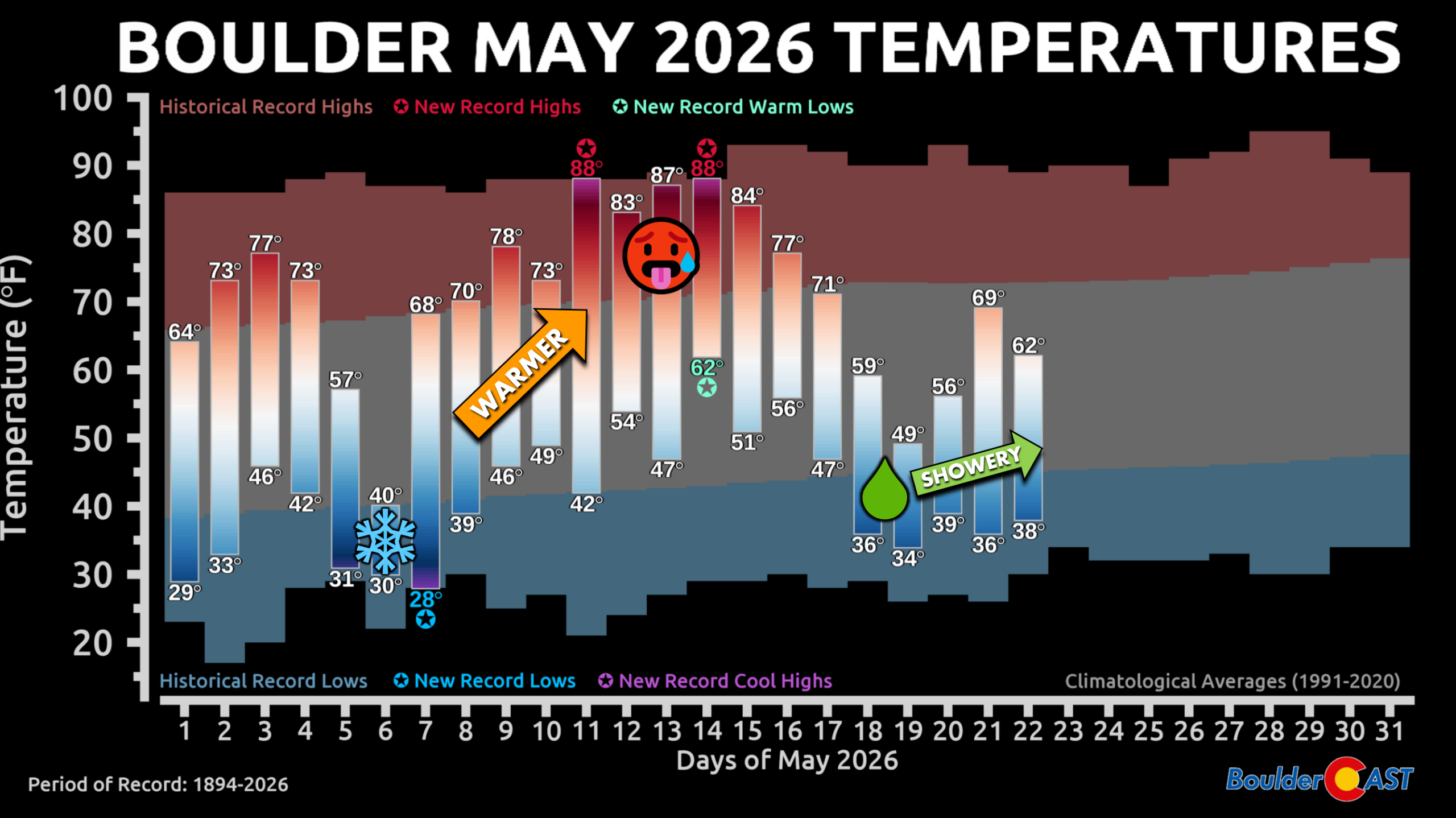
Just as many wondered whether the early‑May moisture blast was a one‑off, the atmosphere answered with a firm “no” when a few days later wet weather returned as another unsettled pattern emerged across the Rockies around May 16th. After a few warm days punctuated by late‑day thunderstorms, the Front Range was hit with its second soaking storm in ten days. A cold area of low pressure swung southward out of the Pacific Northwest and directly into prime position for upslope flow in the Front Range.
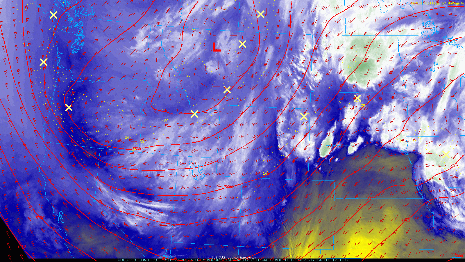
The very same areas hit hardest by the early May storm, Boulder and Larimer Counties, were poised to be in Mother Nature’s sights again for another 1 to 2 inches of liquid. As fortune would have it, this system came through about 5°F warmer, sparing the lower elevations from another destructive snowstorm.
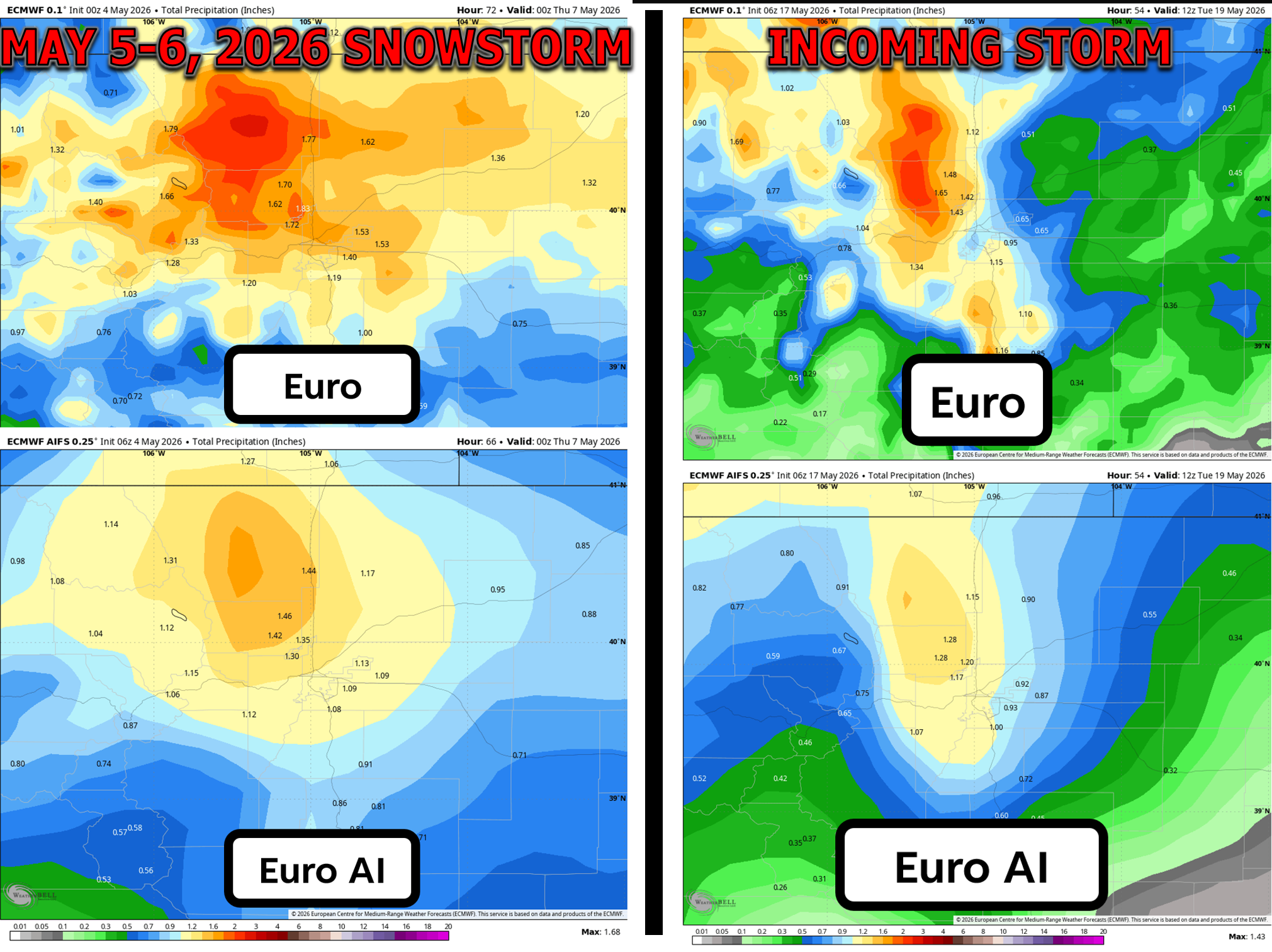
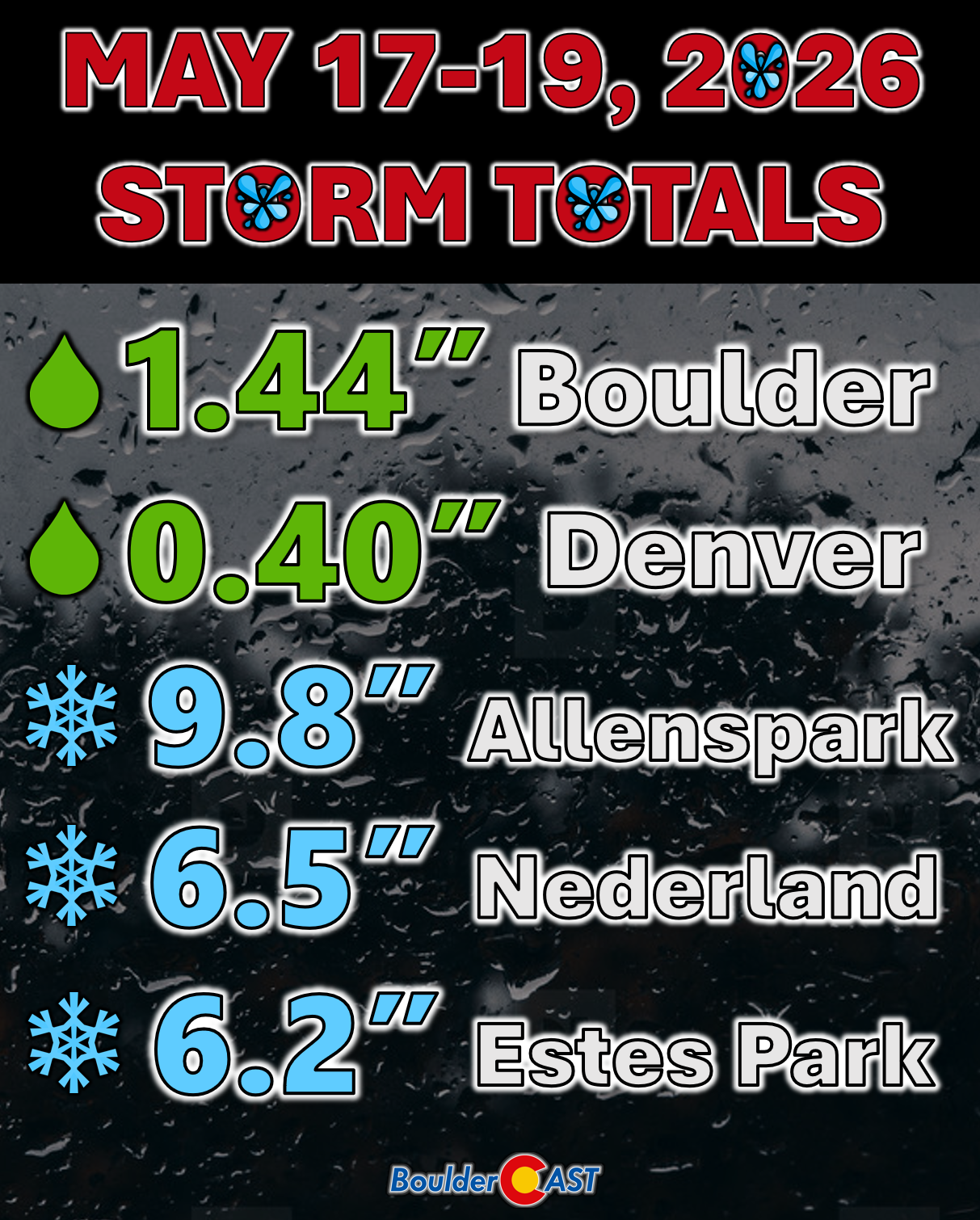
But the Foothills still picked up 5–10 inches, with up to 16 inches along the Divide — enough to delay the seasonal opening of Trail Ridge Road which typically welcomes its first car traffic on the Friday of Memorial Day weekend.
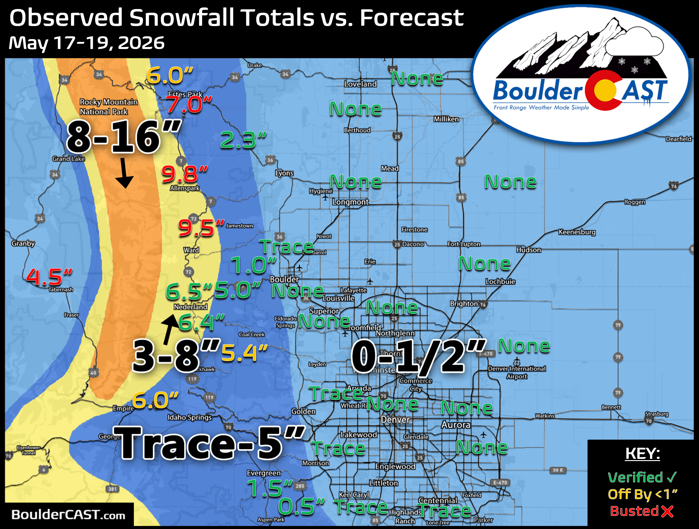
Boulder and Denver both dodged snow from the second storm, but they weren’t able to circumvent significant rain. Boulder added another 1.44″ of liquid from May 17–19 (all rain). Denver’s official total at the airport underperformed (as usual), but most of the Metro area saw 0.75–2″, with the northern Foothills again leading the way.
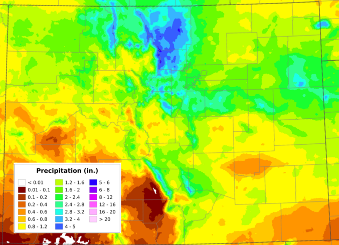
Daily showers and thunderstorms have continued in the days since, reinforcing the Pacific Northwest vibe. Much of Boulder and Larimer Counties now sit between 3 and 5 inches of monthly precipitation, with 2 to 2.5 inches across the broader Metro area.
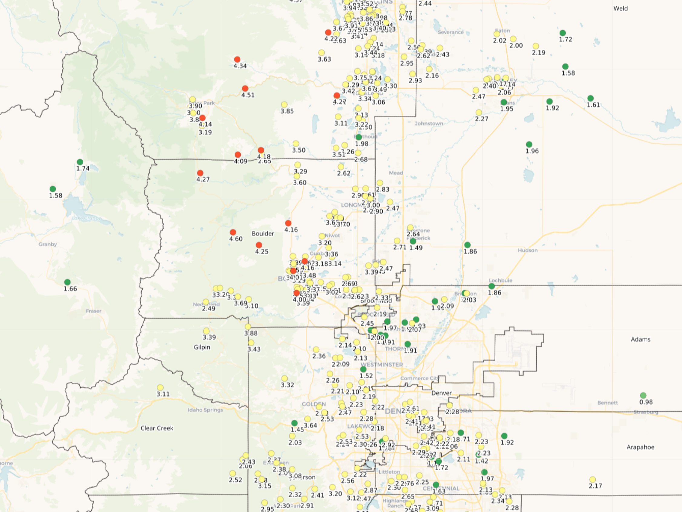
May 1-21, 2026 Denver area precip totals
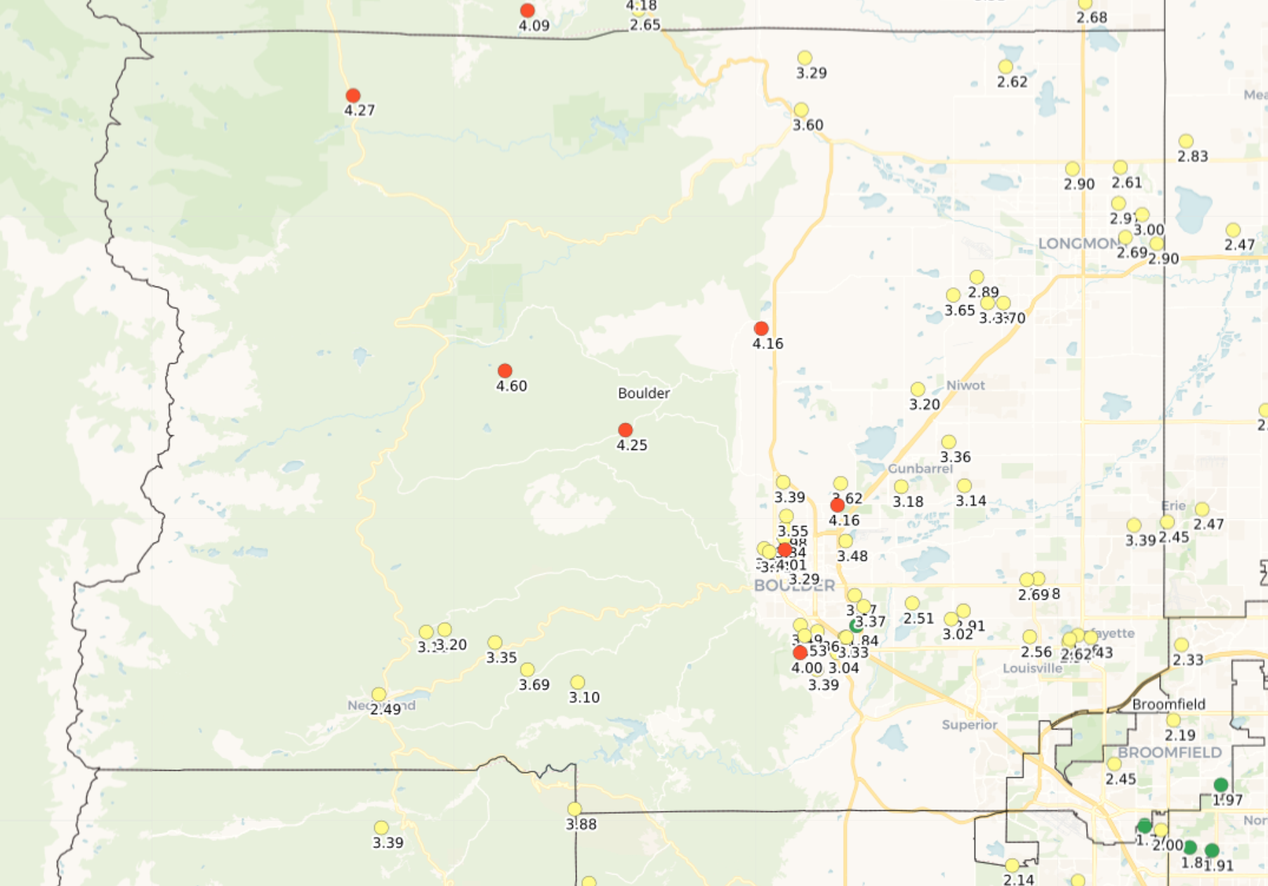
May 1-21, 2026 Boulder County precip totals
Though that may seem like a lot of water, and it technically is, it’s not unusual for this time of year to have many days in a row with showers and gloom, interjected occasionally by significant upslope precipitation events. May is our wettest month of the year after all, and so far, May 2026 has delivered a climatologically appropriate amount of wetness. The recent deluge has definitely been a bit shocking considering how dry the prior 7 months have been.
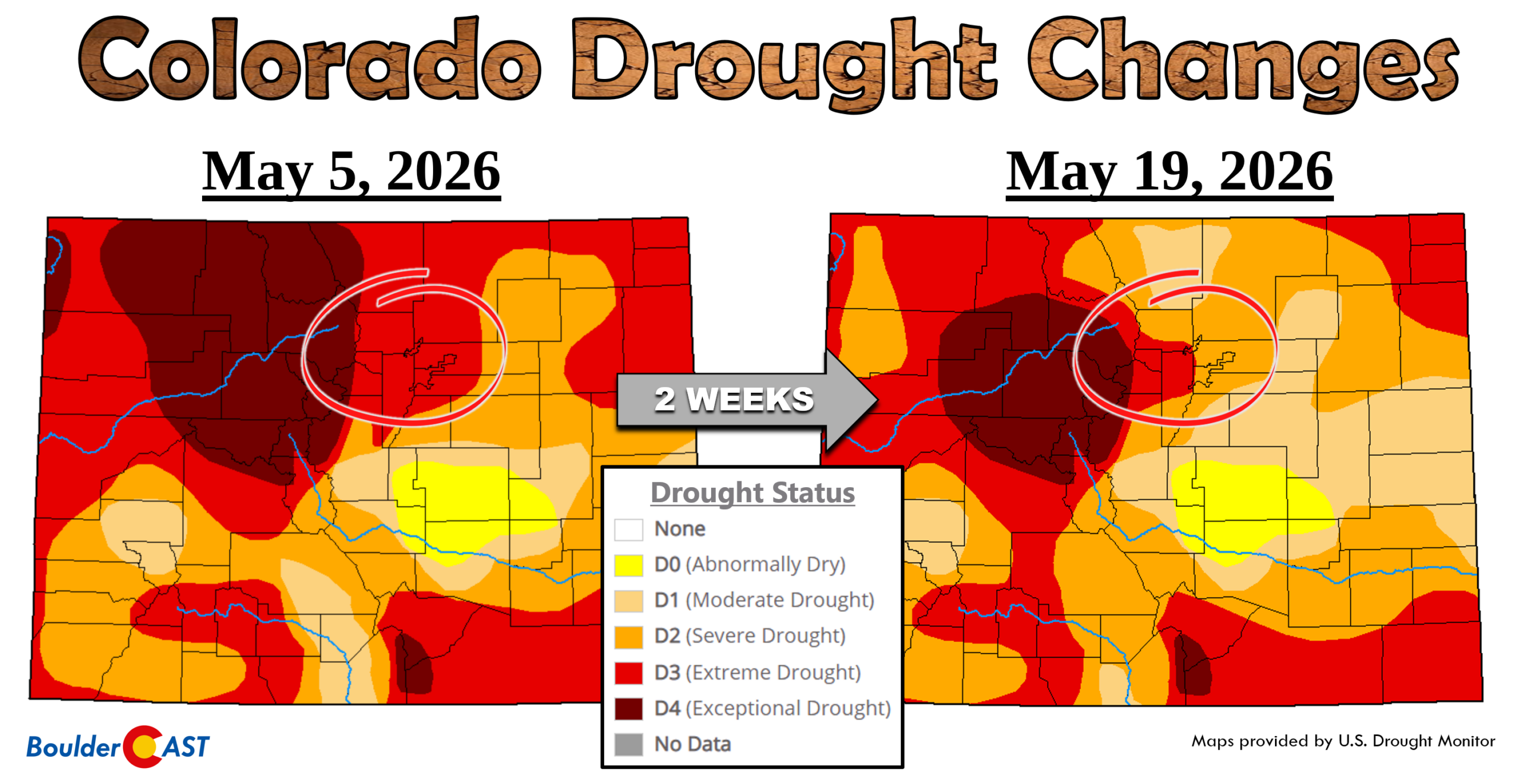
Drought: Improving, But Far From Over
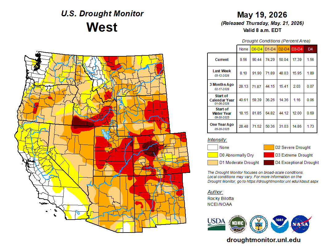
The recent moisture has already nudged drought conditions in the right direction.
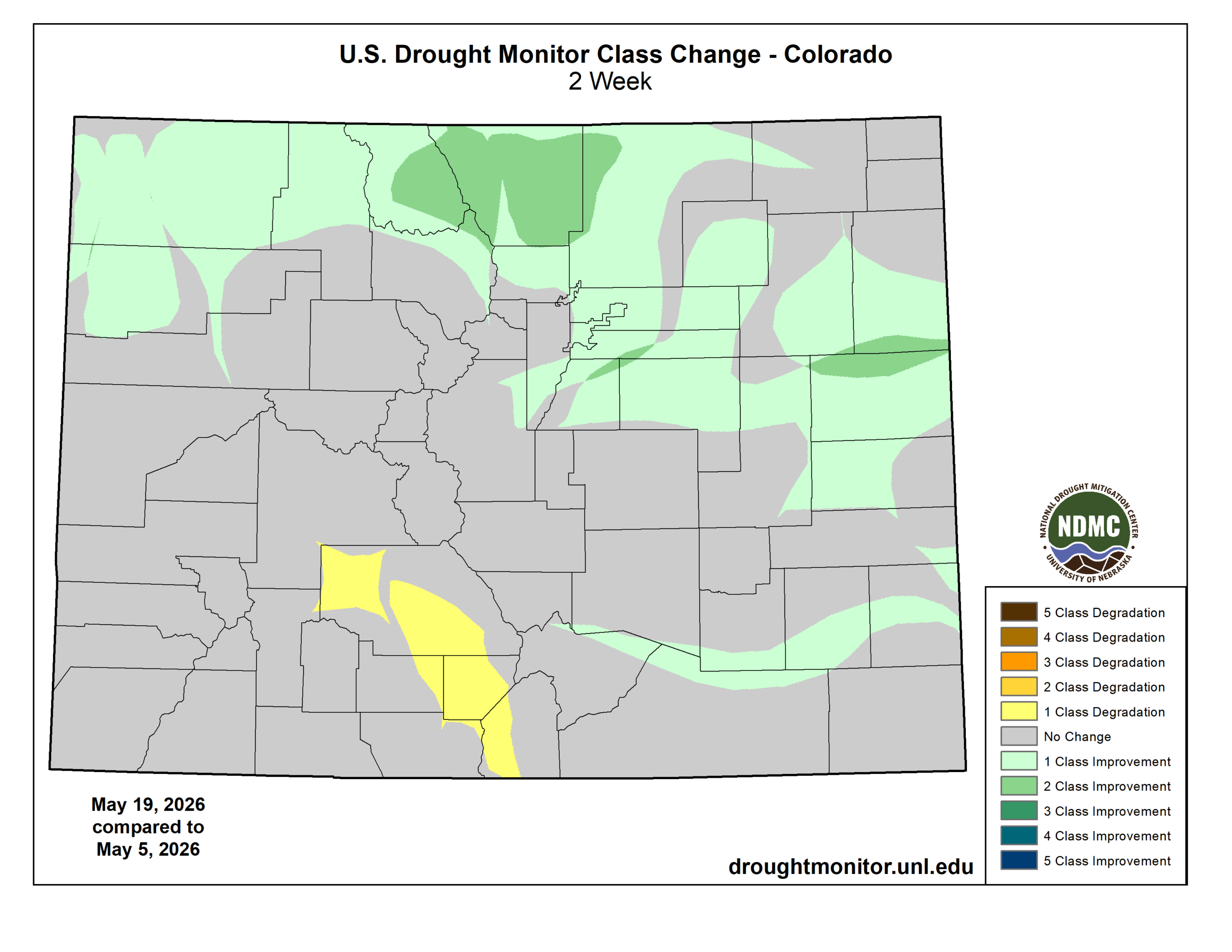
- Larimer and Jackson Counties have improved by two drought classes in two weeks.
- Boulder and Denver Counties have improved by one class.
The amount of moisture we’ve seen this month has been amazing, but it’s not nearly enough to eradicate a drought that has been brewing for the better part of a year in our state. For example, just looking back over the last 12 months, Boulder is running a roughly 6 inch or 30% precipitation deficit. After a wet Spring 2025, the deficit started to appear over the summer due to a lackluster monsoon season. A warm and dry fall further compounded things, including our latest snowfall on record, while the subsequent complete failure of winter across the West has kept that deficit growing.
Even with recent improvements, 96% of Colorado remains in drought, with the Boulder–Denver corridor largely in the Severe to Extreme realm. At this time, we’re not expecting any major change of course by regional municipalities regarding ongoing water restrictions or fire bans. A few more big storms and maybe that changes, but we’re not there yet.
And more importantly, our wet stretch has been highly localized. Much of the West has seen no meaningful precipitation this month or this spring.
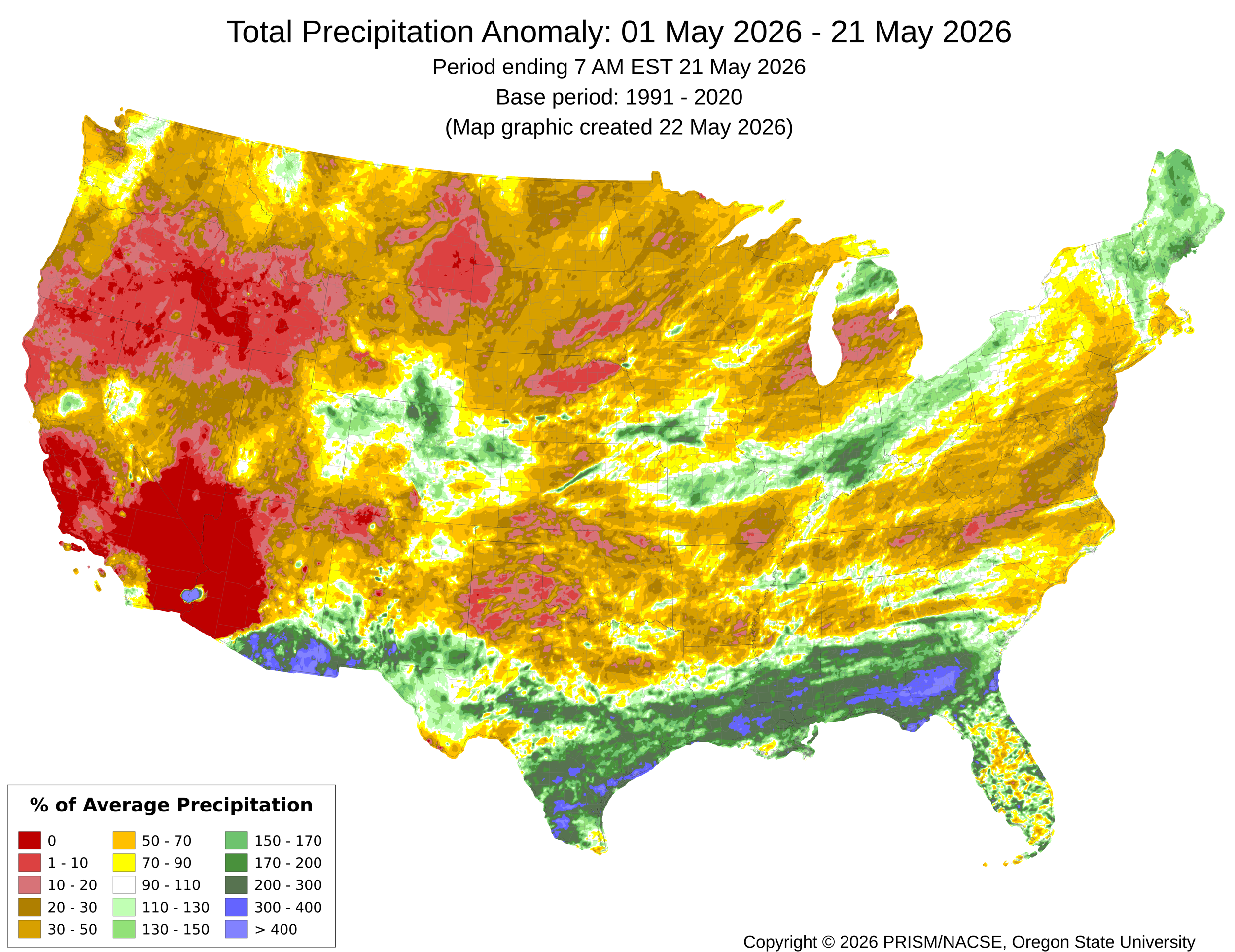
Snowpack remains at record low levels in a majority of Western river basins.
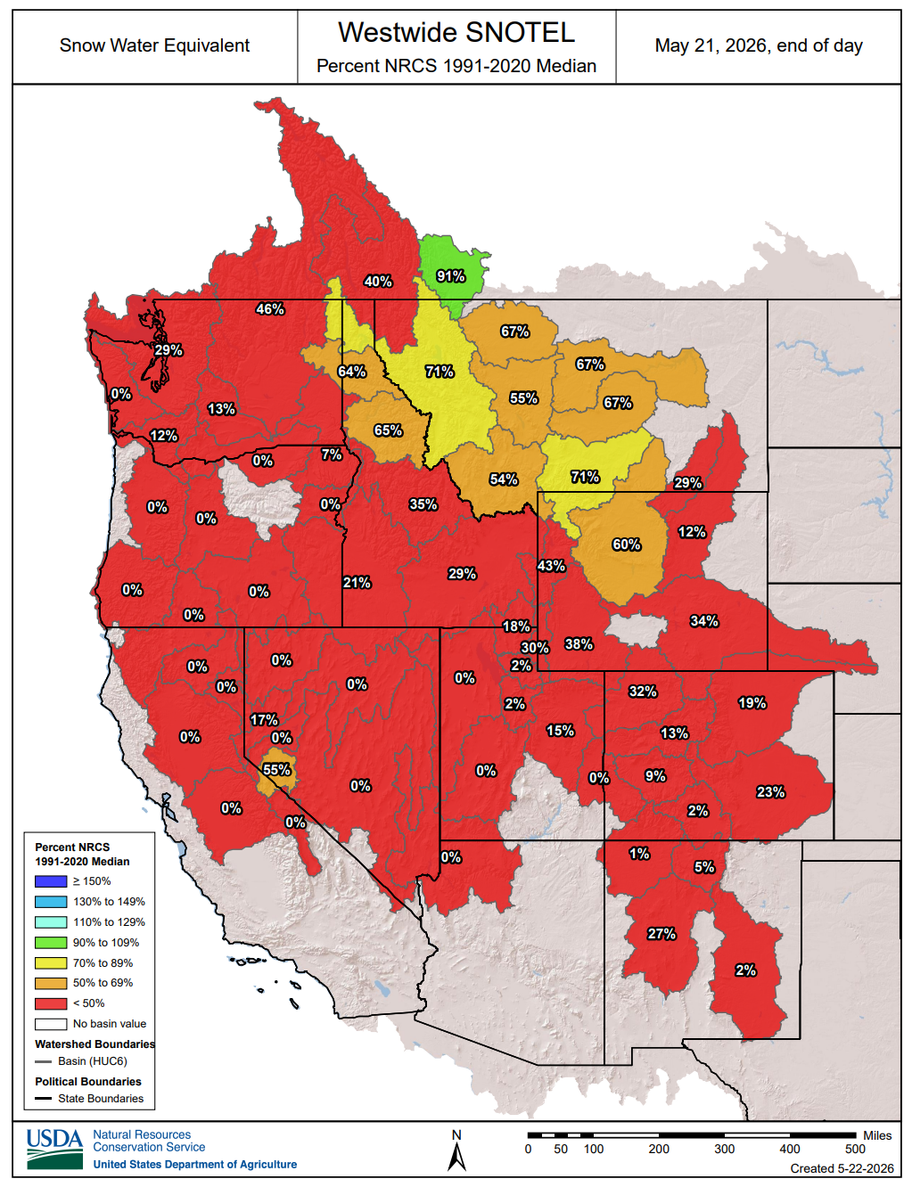
The overall narrative hasn’t changed: the broader West is still in a very tough spot heading into what will likely be a long, fiery and smoky summer.
Looking ahead: Keeping the moist momentum going
There is some good news.
Memorial Day weekend looks pleasant for the Boulder–Denver area:
- Saturday: Sunny, 70s — the pick of the weekend
- Sunday–Monday: 80s with late‑day thunderstorms
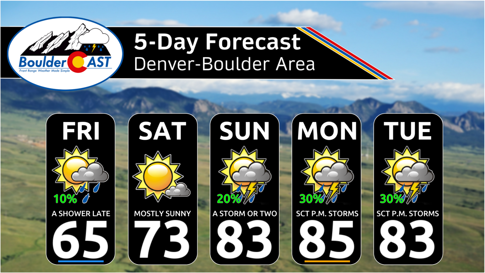
Another unsettled pattern is brewing for next week, but the main storm likely will stall over the Great Basin. That would place Colorado under a warm and moist southwest flow, favoring daily thunderstorms rather than widespread, chilly upslope deluges. Still, it’s a favorable setup for continued wet weather.
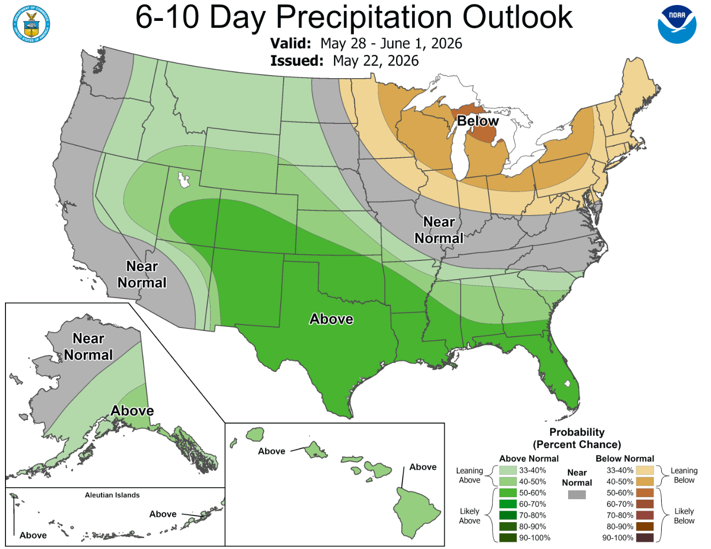
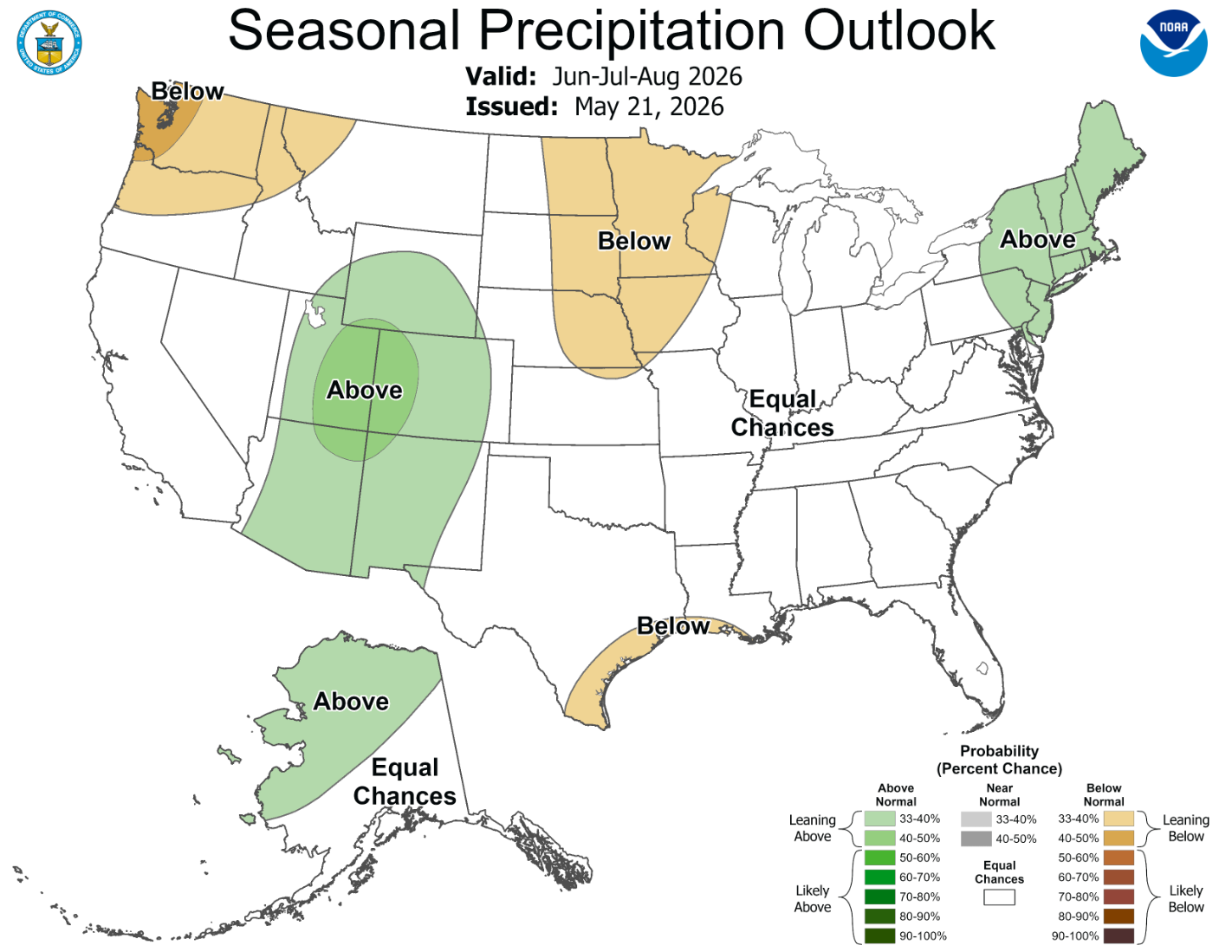
Plus, the door remains wide open for additional drought improvement heading through the summer, especially considering we’re likely to see a monsoon enhanced by a rapidly developing strong El Niño. Coloradans, and residents of the other drought-stricken Four Corners states, should like the look of the latest summer outlook issued yesterday by the Climate Prediction Center.
That’s all for now. Have a great holiday weekend!
![]()
Spread the word, share our crazy Colorado weather:
Go Premium, get all the perks.
Daily Forecast Updates
Get our daily forecast discussion every morning delivered to your inbox.
All Our Model Data
Access to all our Colorado-centric high-resolution weather model graphics. Seriously — every one!
Ski & Hiking Forecasts
6-day forecasts for all the Colorado ski resorts, plus more than 120 hiking trails, including every 14er.
Smoke Forecasts
Wildfire smoke concentration predictions up to 72 hours into the future.
Exclusive Content
Weekend outlooks every Thursday, bonus storm updates, historical data and much more!
No Advertisements
Enjoy ad-free viewing on the entire site.


You must be logged in to post a comment.