A warm, summer-like pattern is about to take over the Front Range in the middle of May. This week’s weather is driven by a robust mid‑level ridge anchored over the Desert Southwest, producing strong subsidence and a sustained warm anomaly across Colorado. A weak cold front on Tuesday will briefly cool us off, but its effect will be short-lived, with near-record heat building back in by midweek. Rain chances through the extended period remains quite low given the setup, but the late-week period is somewhat uncertain. We break down the dynamics driving this pattern and the implications it will have for the Denver–Boulder corridor through this warm, mostly dry stretch ahead.
This week’s highlights include:
🌞 Strong Southwest ridge dominates, pushing highs 10–15°F above normal for most of the week.
🌬️ Tuesday’s weak cold front brings brief relief, dropping temps into the upper 70s with easterly upslope.
🔥 Near-record heat rebounds midweek, with Wednesday and Thursday likely the warmest days — upper 80s to near 90°. Record highs possible.
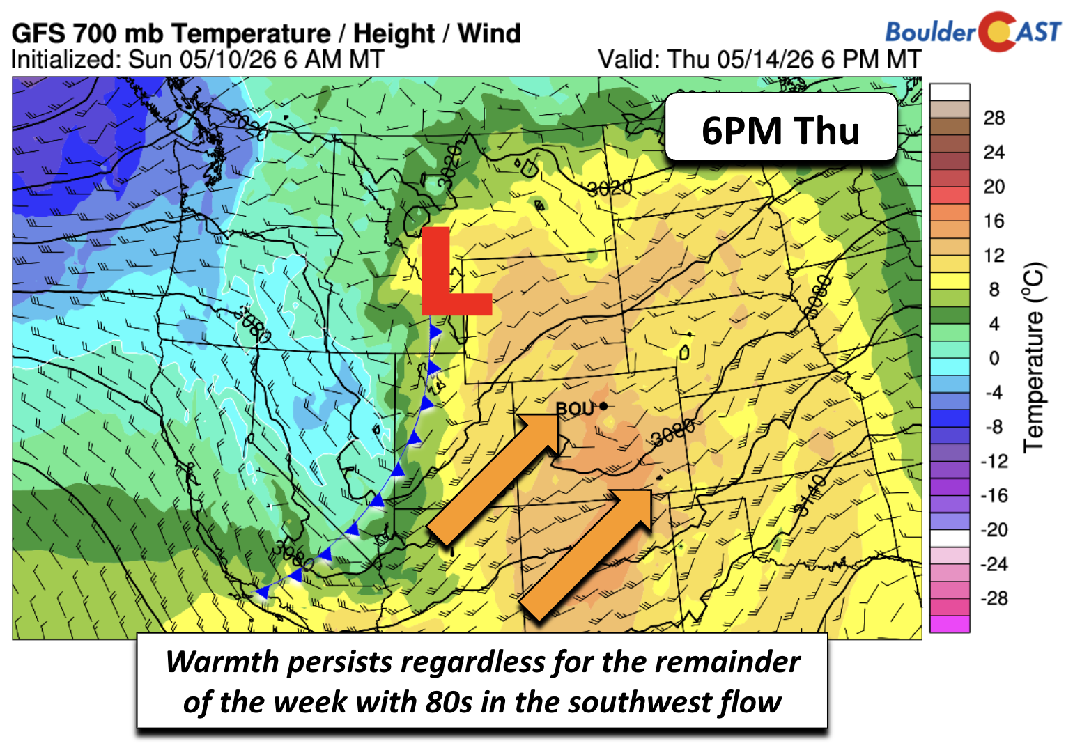
🌡️ Persistent southwest flow keeps the Front Range warm and dry as a Pacific closed low approaches but stays displaced.
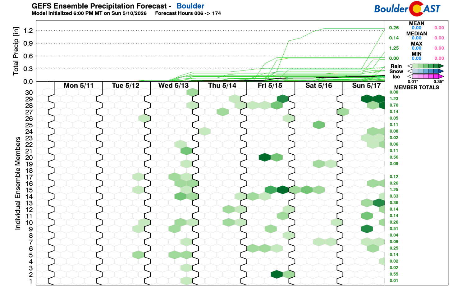
🌦️ Rain chances stay low (~10%), with limited forcing and downslope suppressing meaningful showers Tuesday–Friday.
🚿 Late‑week uncertainty remains, but most solutions favor continued warmth and minimal moisture — irrigation recommended.
DISCLAIMER: This weekly outlook forecast is created Monday morning and covers the entire upcoming week. Accuracy will decrease as the week progresses as this post is NOT updated. To receive daily updated forecasts from our team, among many other perks, subscribe to BoulderCAST Premium.

Go Premium, get all the perks.
Daily Forecast Updates
Get our daily forecast discussion every morning delivered to your inbox.
All Our Model Data
Access to all our Colorado-centric high-resolution weather model graphics. Seriously — every one!
Ski & Hiking Forecasts
6-day forecasts for all the Colorado ski resorts, plus more than 120 hiking trails, including every 14er.
Smoke Forecasts
Wildfire smoke concentration predictions up to 72 hours into the future.
Exclusive Content
Weekend outlooks every Thursday, bonus storm updates, historical data and much more!
No Advertisements
Enjoy ad-free viewing on the entire site.
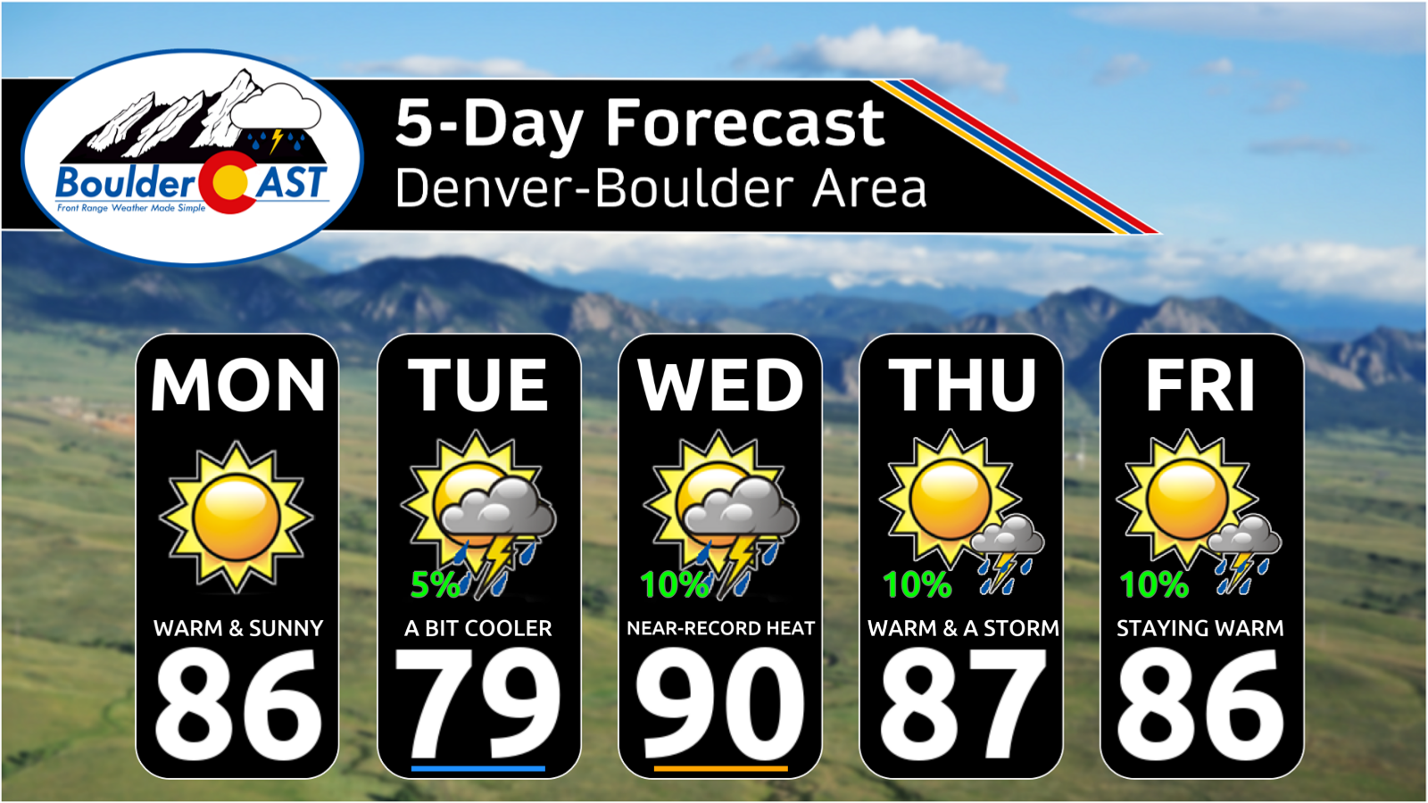
Sunny and much above normal
Amid‑May warm spell is about to take hold across Colorado as a broad, anomalous upper‑level ridge builds over the Desert Southwest. The ridge — centered over Arizona and New Mexico — is unusually strong for this point in the season and will dominate our weather for much of the week. After a weekend spent in the comfortable 60s and 70s, the Denver–Boulder corridor now transitions into a stretch where 80s become the rule, not the exception. Outside of Tuesday’s brief interruption, daily highs will run 10–15 degrees above climatology.

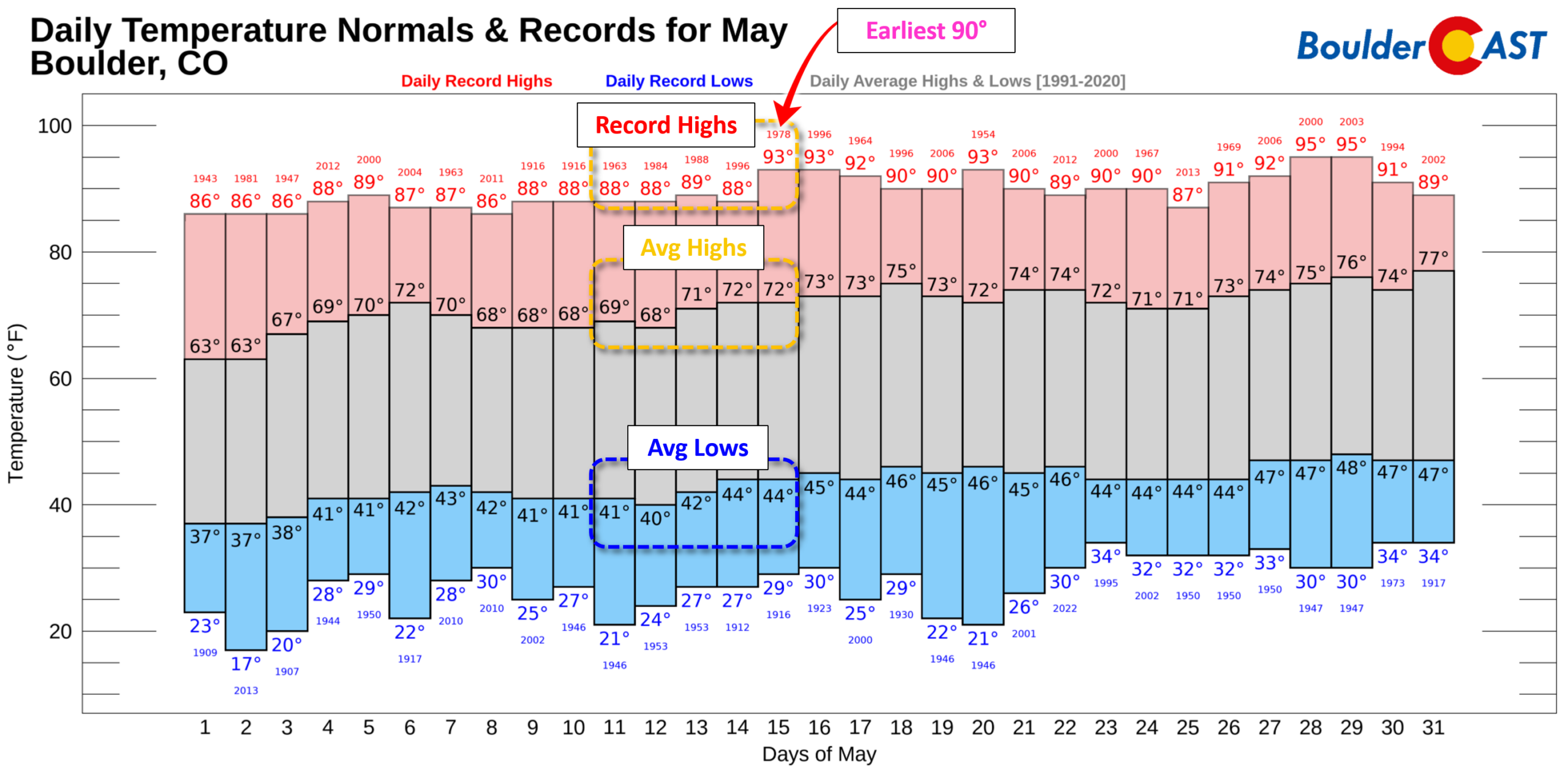
For context, mid‑May normals in Boulder and Denver sit in the low 70s for highs and low–mid 40s for lows. This week’s pattern will push us well beyond that baseline, with the warmest days flirting with early‑season heat and even record highs.
We kick off the week with highs in the mid to upper 80s Monday, a sharp jump from the 60s just 24 hours earlier — a testament to how quickly the Front Range can warm under downslope flow and strong May sun.
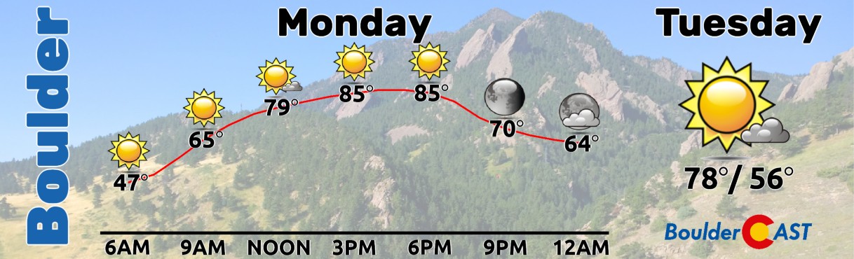
A brief cool down Tuesday
A shallow but effective cold front slides south early Tuesday morning, reaching the higher Foothills, southeastern Colorado, and even into southern Kansas. Behind it, easterly upslope takes over, pushing the warmest air back toward the Four Corners. Tuesday is quickly becoming the lone “cool” day of the week, with highs in the upper 70s — still above normal, but noticeably different from Monday’s heat.
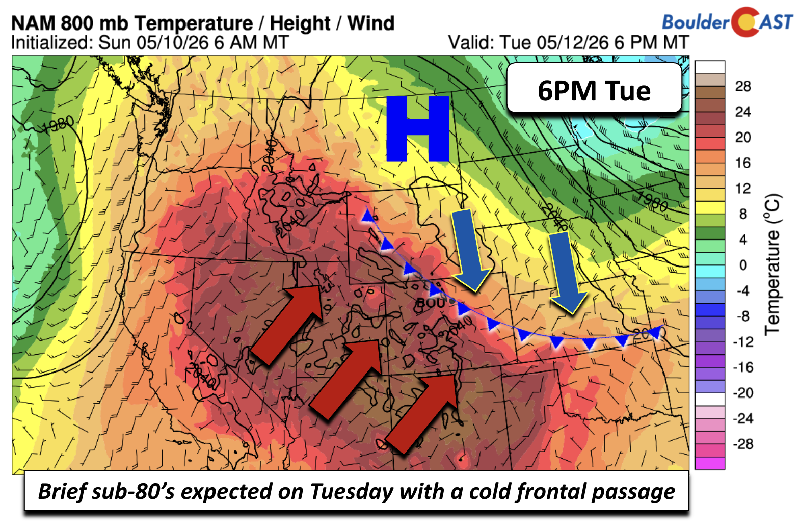
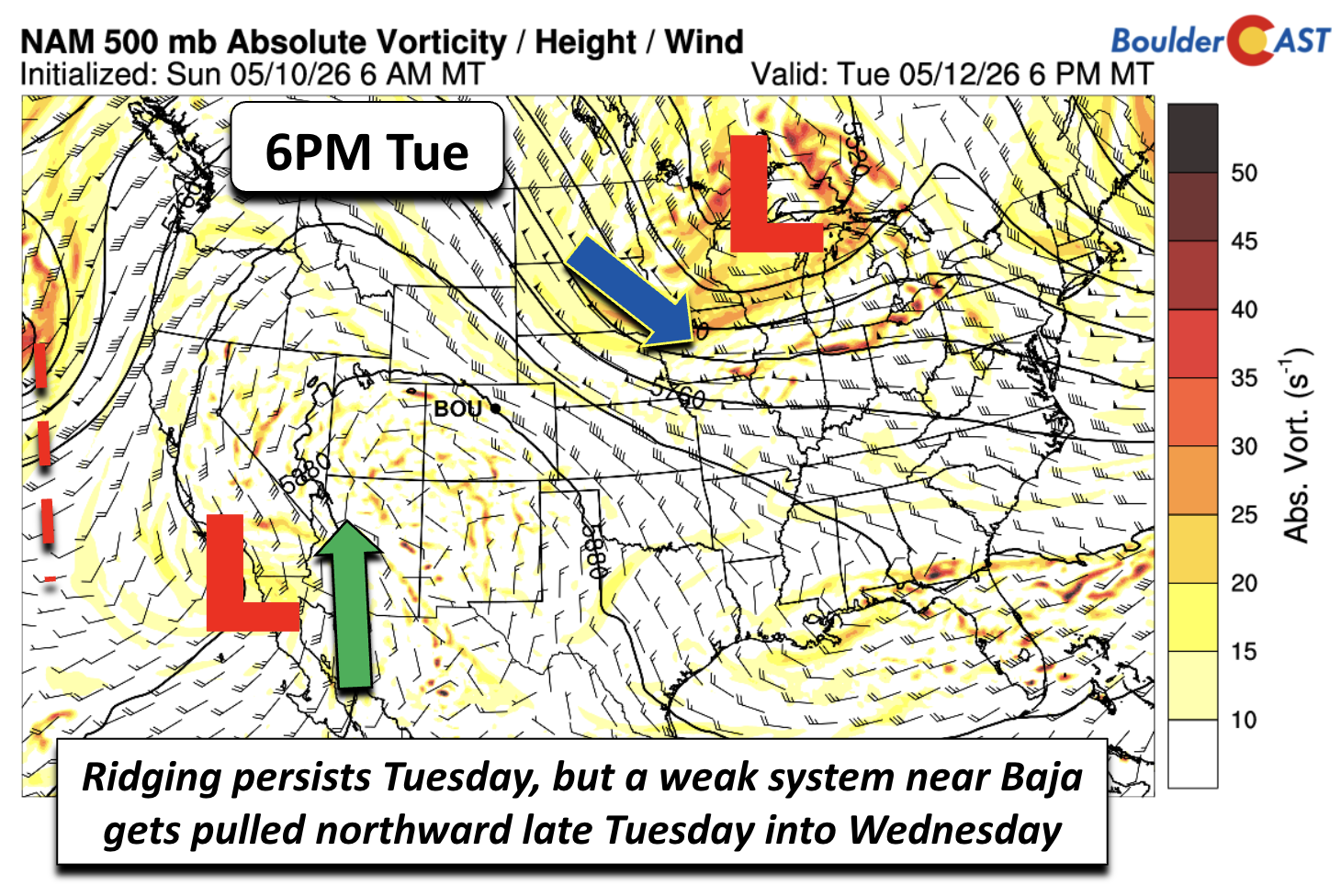
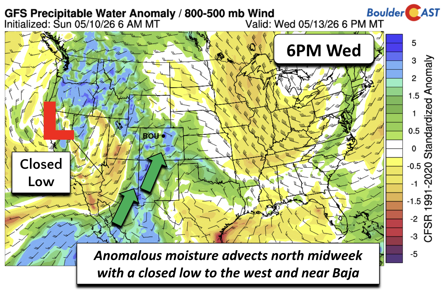
On the synoptic scale, a weak vorticity maximum near Baja California will begin to drift northward, steered by a larger closed low spinning over the Pacific. This Baja disturbance attempts to funnel moisture into Arizona and eventually Colorado by midweek. However, much of this energy may get deflected west of the ridge toward Nevada, limiting any meaningful shower development.
Warm to hot midweek
As the Pacific closed low moves onshore Wednesday, it will help tug deeper moisture and warmer air eastward, effectively sweeping Tuesday’s cooler air mass into the Midwest and Great Lakes. Wednesday may challenge Thursday for the title of warmest day of the week, with both days expected to land in the mid to upper 80s and in record high territory.
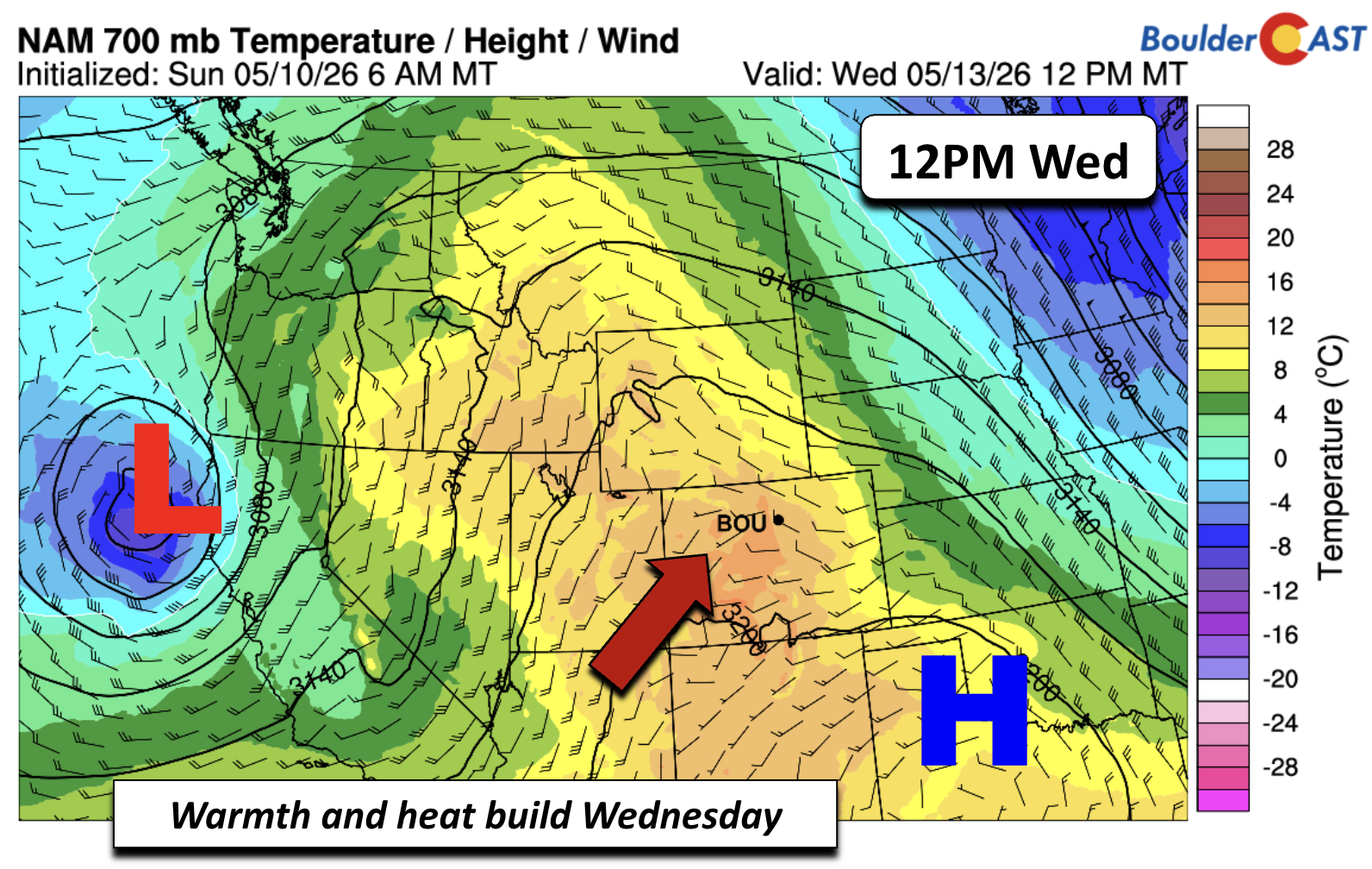
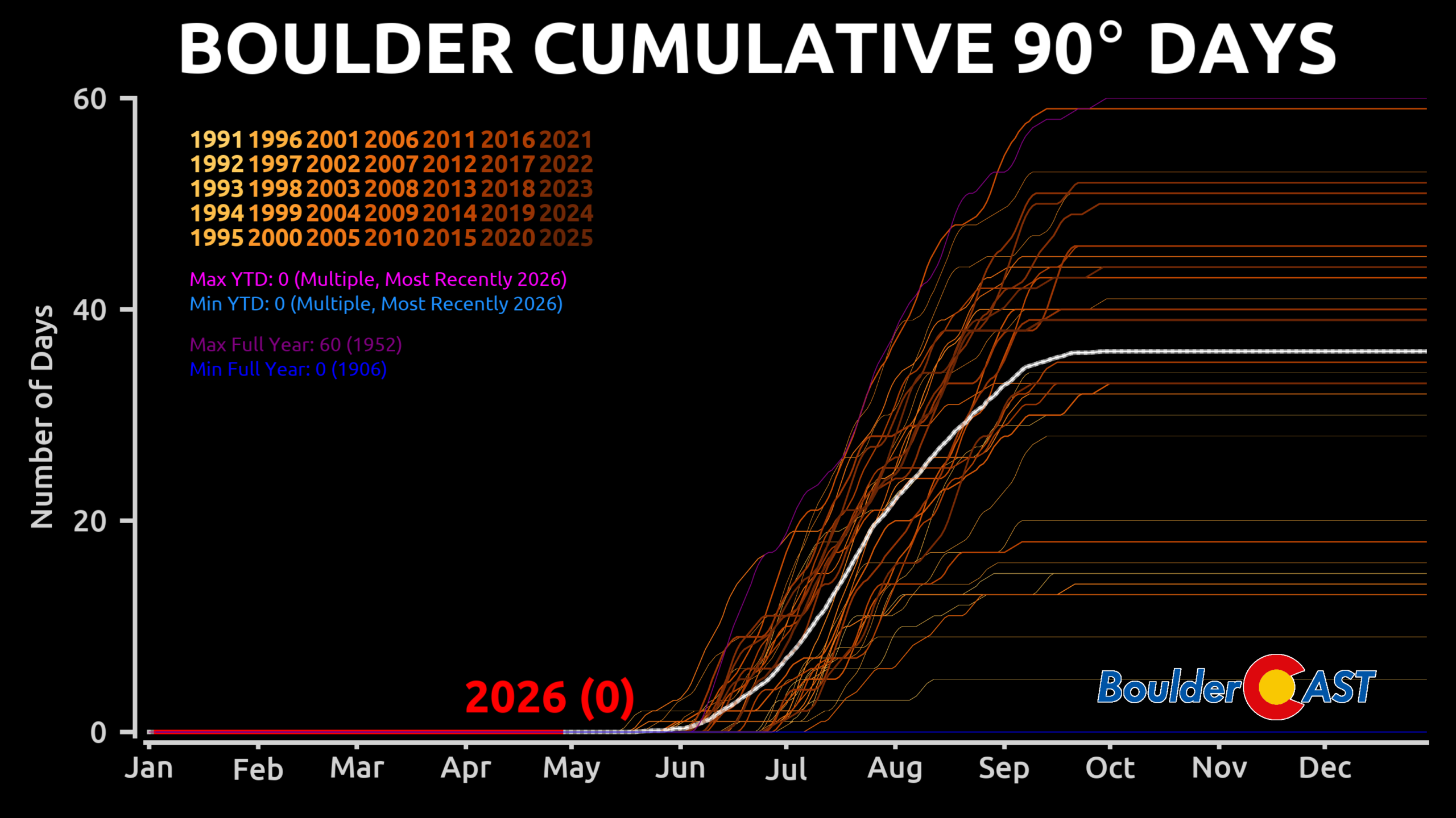
Could a few isolated 90° readings pop up along the Urban Corridor? Absolutely — but 90s should not be that widespread. If Boulder hits 90° on Wednesday it would be the first of the year and the earliest 90° reading on record (May 15th from 1978 is current earliest date).
By Thursday, the closed-low will be positioned somewhere near Utah or Idaho, maintaining southwest flow and keeping the heat entrenched across Colorado. While warm temperatures well into the 80s are favored through the end of the week, model spread in the exact placement of the low introduces some uncertainty to where we land.
Rain chances slim but not zero (Tuesday–Friday)
While not a bone‑dry pattern, this week offers only low‑end precipitation chances. The GEFS ensemble shows scattered, inconsistent signals for isolated showers from Tuesday through Friday — but no strong consensus on timing or coverage.
Tuesday
Any shower potential is tied to the morning cold front. Some models hint at weak instability in the upslope regime, but no organized forcing is present. If anything, the front looks to mostly stabilize the lower elevations. A token 5% chance is appropriate and we think activity would mainly be focused over the higher terrain.
Wednesday
The northward‑advecting Baja shortwave and the onshore Pacific low combine to boost precipitable water values to slightly anomalous levels for mid‑May. Moisture is the only real ingredient; forcing remains weak. Expect 10-15% afternoon/evening shower chances, but persistent westerly downslope should keep most areas dry.
Thursday
GEFS members showing higher probabilities for this day appear too aggressive. As the system shifts into the Great Basin, moisture gets pulled east into the Plains while drier air invades western Colorado. If moisture lingers longer than expected, a low‑end severe threat could develop along a dryline or surface trough in eastern Colorado or western Kansas. For now, thunderstorm chances remain around 10% locally, but perhaps a bit higher east of Denver.

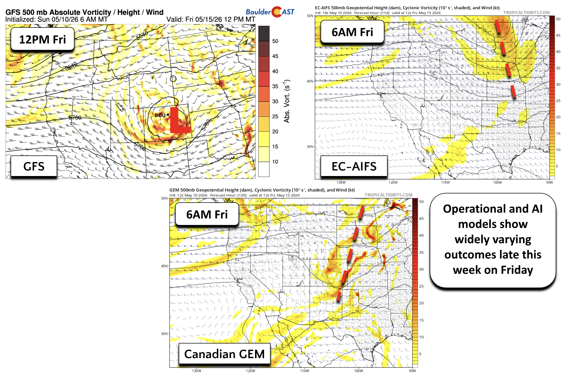
Friday
Friday is the wildcard of the week. Operational models, and their AI‑assisted counterparts, diverge significantly on the evolution of the closed low:
- GFS: Tracks the low directly over Colorado → cooler highs, more clouds, and better rain chances.
- Canadian GEM: Shows a sheared trough from the Dakotas to New Mexico → general downslope and limited moisture.
- Euro + Euro AI: The driest solutions → trough passes far north, westerly flow dominates, warm and dry.
Given the spread, the safest call for Friday right now is highs in the 80s with low confidence in any precipitation (10%).
Precipitation chances through the week, while frequently present, remain very low. Gardeners or lawn-owners hoping for natural watering should not count on it this week — irrigation remains the safer bet.
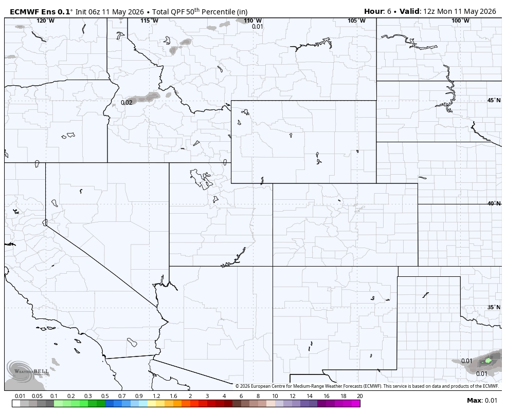
European ensemble median precipitation amount forecast animation through Friday night
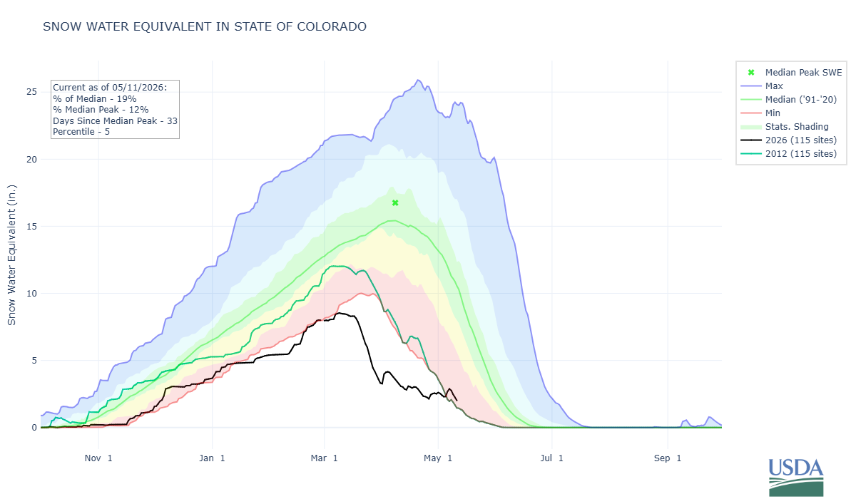
Colorado’s statewide snowpack briefly jumped out of the “worst on record” category following last week’s wet snowstorm — that now falls to 2011-2012 winter for mid-May). However, this week’s hot, sunny and largely dry conditions will continue to rapidly chip away at our remaining snowpack, even in the highest of elevations.
Bottom Line
A strong Southwest ridge will keep Colorado warm and mostly dry this week, with highs running 10–15°F above normal and only Tuesday offering a brief dip into the upper 70s behind a shallow cool front. Midweek heat rebounds quickly towards 90° and record highs. While isolated thundershowers remain possible Tuesday through Friday, the pattern lacks any meaningful forcing. Model spread late week leaves Friday somewhat uncertain, but the dominant signal favors continued warmth and limited moisture.
Enjoy the hot week!

Forecast Specifics:
Monday: Mostly sunny and much warmer. Highs in the middle 80s for the Plains and middle 70s in the Foothills.
Tuesday: Cooler. Highs in the upper 70s for the Plains and upper 60s for the Foothills under partly cloudy skies. A late-day isolated shower cannot be ruled out, mainly across the higher terrain (5-10% chances).
Wednesday and Thursday: Heat builds over the region. Highs in the upper 80s to near 90 for the Plains and upper 70s in the Foothills under increasing clouds. There could be a few late-day showers (10-20% chances), especially east of Denver. Record highs may be challenges these days.
Friday: Increasing clouds with temperatures in the lower to mid 80s in the Denver Metro and lower 70s in the Foothills. Likely totally dry but still uncertain.
Weekend: Model uncertainty further grows from Friday, lowering forecast confidence. Expect warm weather to continue in the 80s, along with low-end shower chances.
DISCLAIMER: This weekly outlook forecast is created Monday morning and covers the entire upcoming week. Accuracy will decrease as the week progresses as this post is NOT updated. To receive daily updated forecasts from our team, among many other perks, subscribe to BoulderCAST Premium.
Go Premium, get all the perks.
Daily Forecast Updates
Get our daily forecast discussion every morning delivered to your inbox.
All Our Model Data
Access to all our Colorado-centric high-resolution weather model graphics. Seriously — every one!
Ski & Hiking Forecasts
6-day forecasts for all the Colorado ski resorts, plus more than 120 hiking trails, including every 14er.
Smoke Forecasts
Wildfire smoke concentration predictions up to 72 hours into the future.
Exclusive Content
Weekend outlooks every Thursday, bonus storm updates, historical data and much more!
No Advertisements
Enjoy ad-free viewing on the entire site.
Enjoy our content? Give it a share!


You must be logged in to post a comment.