
Well, our snowfall forecast for the sloppy weekend storm ended up being a tad off in many areas. Hopefully our in-depth discussions in the days leading up to the event highlighted that the exact outcome of this warmer-than-usual storm was highly uncertain. We first review the record-breaking precipitation and snowfall totals across the Front Range. Then we discuss what went wrong with the forecast and dive into the finer details of this implausible moisture-infused winter storm.

Go Premium, get all the perks.
Daily Forecast Updates
Get our daily forecast discussion every morning delivered to your inbox.
All Our Model Data
Access to all our Colorado-centric high-resolution weather model graphics. Seriously — every one!
Ski & Hiking Forecasts
6-day forecasts for all the Colorado ski resorts, plus more than 120 hiking trails, including every 14er.
Smoke Forecasts
Wildfire smoke concentration predictions up to 72 hours into the future.
Exclusive Content
Weekend outlooks every Thursday, bonus storm updates, historical data and much more!
No Advertisements
Enjoy ad-free viewing on the entire site.
A veritable deluge of rain and snow Saturday
Mother Nature unleashed an absolute deluge of precipitation on the Front Range over just an 18-hour period late Friday night through Saturday evening with some portions of the Metro area receiving upwards of 2″ of liquid equivalent (rain and melted snow water), more precipitation than fell here over the prior two months! Even the places which were let off easy from this impressive storm saw upwards of 0.75″ this weekend.
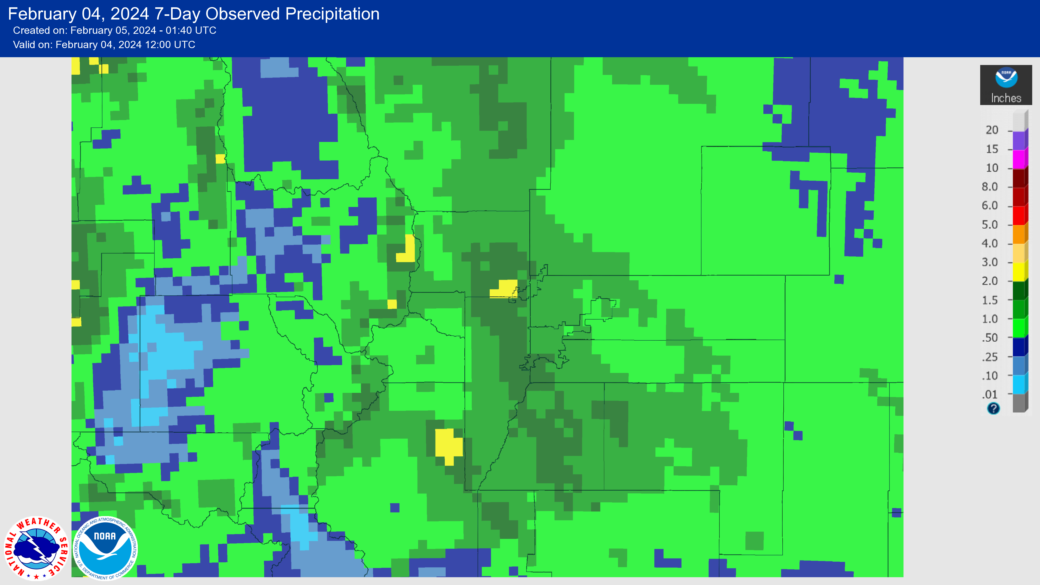
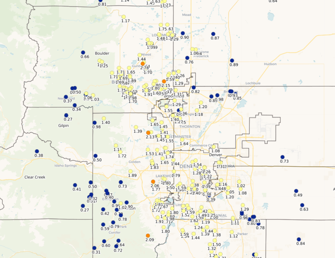
Observed precipitation totals from February 2-3, 2024 storm (rain and melted snow water included in these totals)
This truckload of much needed moisture was tied to a southern-track low pressure that spawned across far southeast Colorado — and boy was this storm beautiful. Just look at the GOES-East water vapor imagery from Saturday!
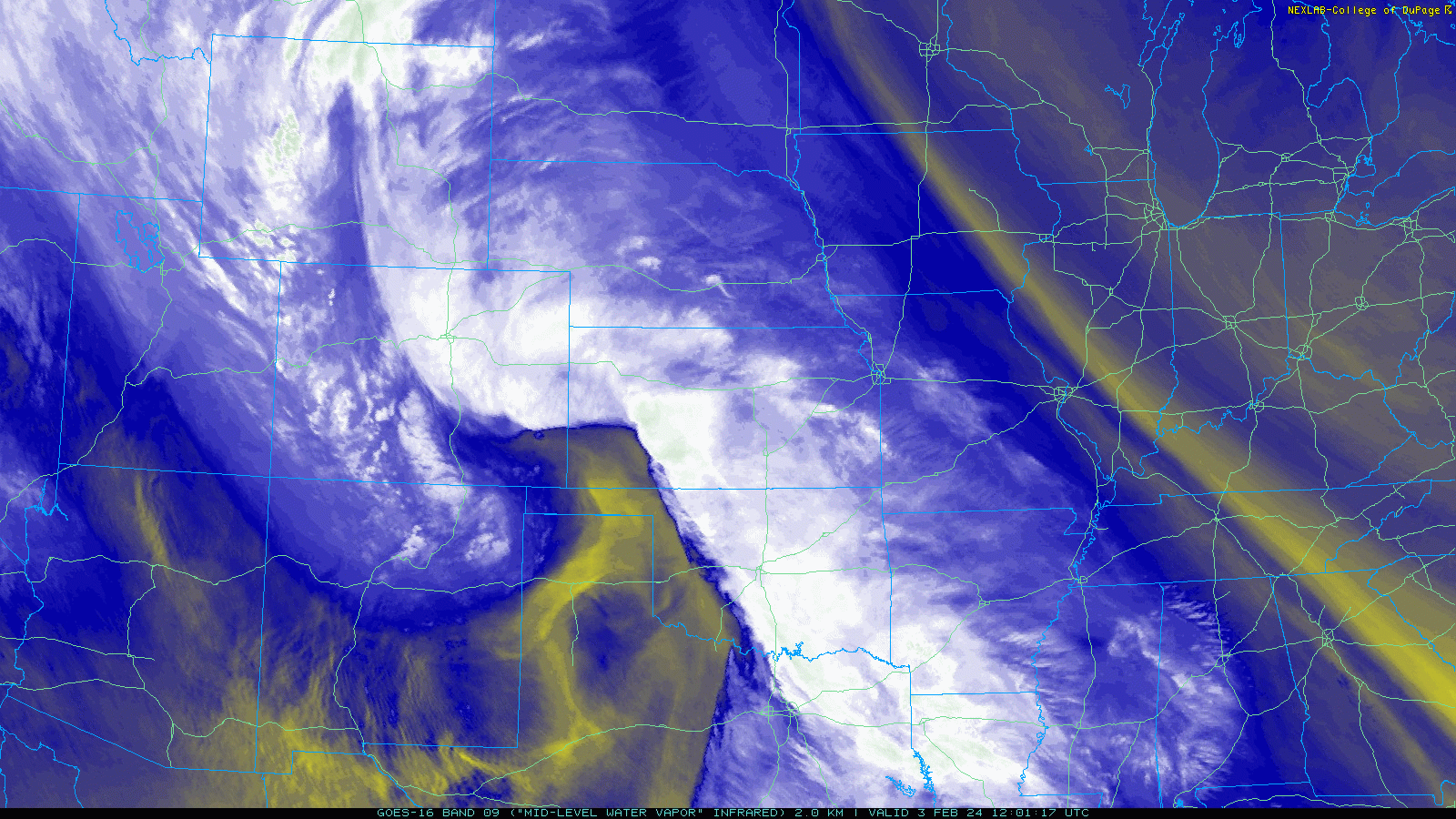
Here’s a closer look at just northern Colorado — now that is some weather eye candy!

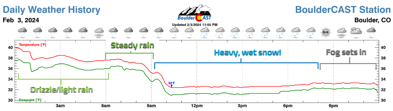
Here in Boulder, things initially started as drizzle and light rain showers later Friday night with temperatures in the upper 30s as southeasterly upslope flow began to intensify. A more steady shield of precipitation moved in Saturday morning with temperatures dropping enough to change rain over to snow — and heavy snow at that!
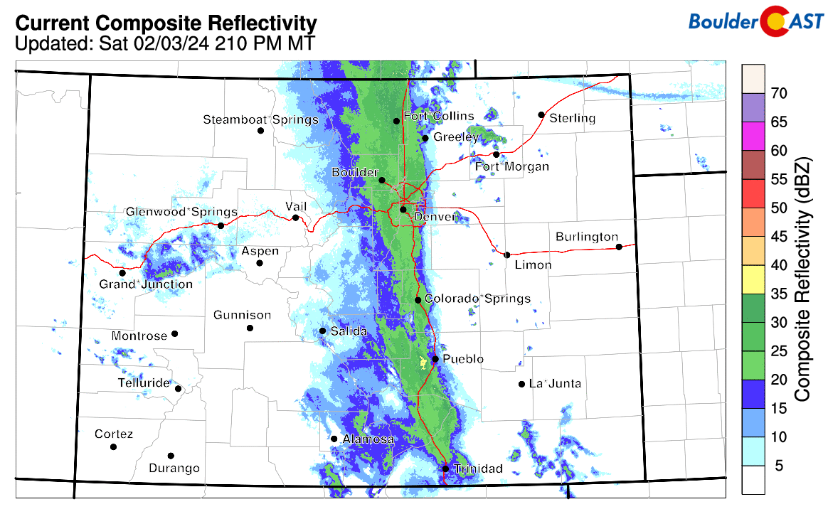
The radar animation below spans most of the storm. Notice as the heavy shield of precipitation moved westward and banked up against the terrain all day long. It was within this heavy band of precipitation that rain changed to snow and never looked back.
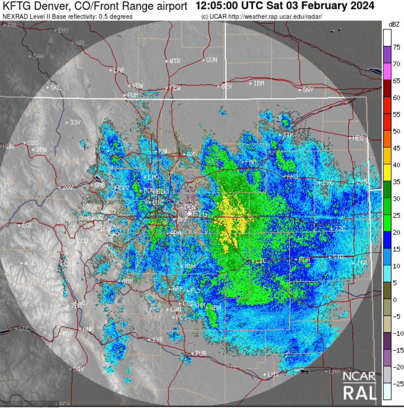
Here’s the view from Boulder on Saturday as the craziest snow was pounding the University of Colorado campus. Yes, those snowflakes are indeed the size of ping pong balls! One of our readers accurately described this time as “Mother Nature vomiting cement from the sky”. We couldn’t agree more!
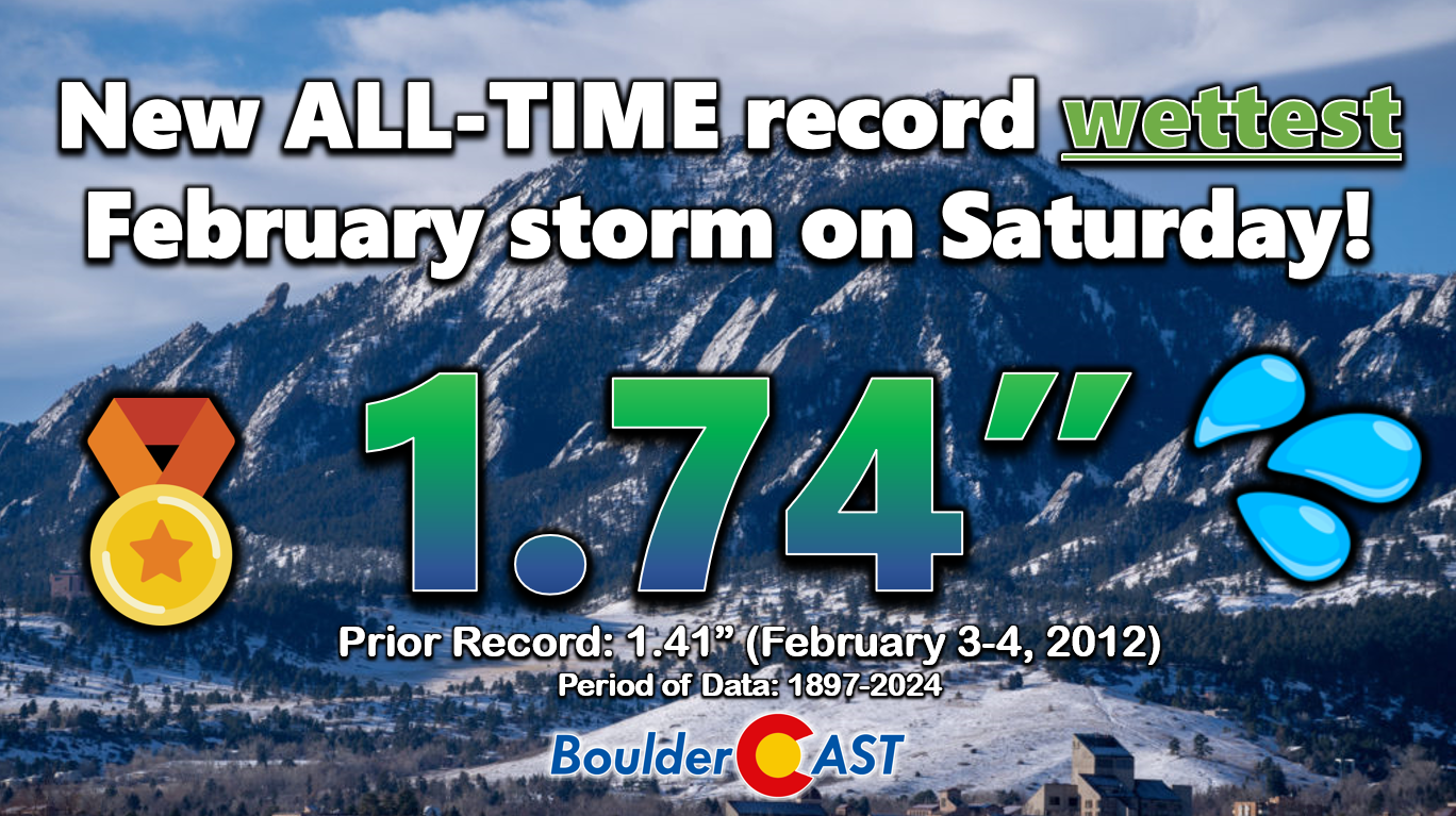
When it was all said and done by Saturday evening, more than 1″ of precipitation had dumped on most of the Front Range. Denver received 0.76″, the third wettest February day ever and a new daily record for February 3rd. Boulder saw more than double that amount, finishing with a staggering 1.74″ of precipitation — good enough to claim top spot as our all-time wettest February storm. New records were also notched for February 3rd and the single wettest February day (1.58″ on both accounts).
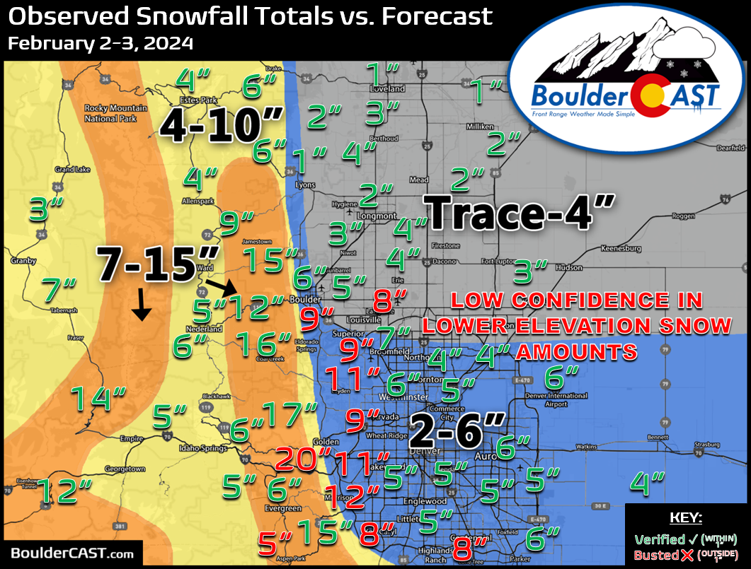
As far as snow, this storm was a BOOMER, unfortunately catching many folks off guard due to a highly uncertain forecast (more on that in a moment)! Our snowfall forecast map for the event is shown below with storm totals overlaid. Green values indicate our forecast verified to within one inch. Red did not. Overall our final forecast for this surprisingly significant winter storm verified somewhat okay. We had the general distribution of snowfall correct — lesser snow north, more south, and the most snow in the lower Foothills from Boulder County southward — but we grossly underestimated just how much snow would fall across portions of the lower elevations. Officially 9.1″ of snow dumped in Boulder, with 5.5″ in Denver. The highest totals, 15 to 20 inches worth, were in the lower Foothills mostly between the elevations of 6500 and 8000 feet.
So why were the forecasts so bad on this one?
It was a long and arduous week for our team trying to predict how this weekend’s winter storm would impact the Denver Metro area. While the general atmospheric setup was well-advertised nearly a week in advance by all major global weather models, the details of exactly how things would play out here in the Front Range were much less certain. Models were literally flip-flopping constantly — from this storm being a complete swing and a miss for us at times, to a run later showing two feet of snow pummeling Boulder and Denver alike. While this variability isn’t that uncommon, especially four plus days in advance, the sheer insanity of the model volatility this week was unlike anything we’ve experienced predicting Front Range weather over the last 15 years. The subtlest of shifts from run-to-run and model-to-model caused vast changes in the overall Front Range forecast. No a single model was immune throughout the week to the volatility. Even up until the final hours, things were still highly uncertain. Heck, even some of our nowcasting efforts were futile on this one. This storm in particular was a stern reminder that Mother Nature is the one in charge of our weather, and sometimes she has a few tricks up her sleeve.
We knew the incoming storm system would be big (big as in large scale), and it’s these bigger storms that introduce broader forecasting challenges, greater uncertainties, and more potential impacts. The scale of this particular low pressure allowed it to wrap in moisture from a remnant atmospheric river blowing in from the Pacific Ocean, but also it established a direct pipeline to the Gulf of Mexico once it started wrapping-up in southeast Colorado, the latter mixing in even more uncertainty as moisture-rich flow from the Gulf is also warm by its very nature.
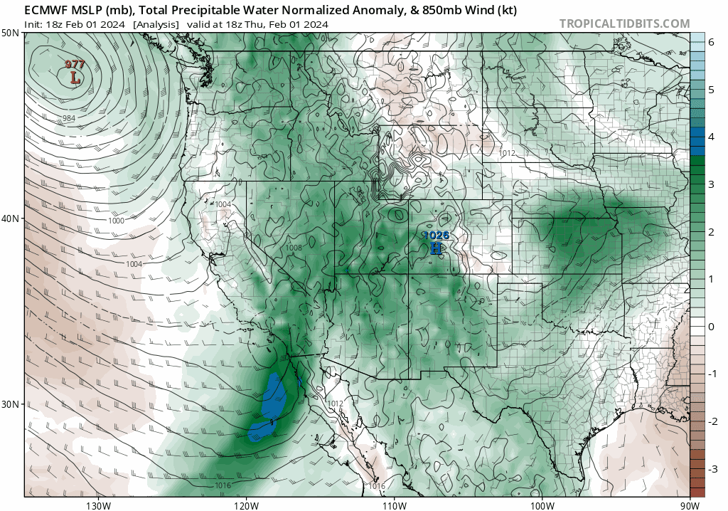
So we had a big, warm, juicy storm headed our way — that was clear all week long — but we really didn’t have a clear-cut cold airmass, obviously something that is needed for snow. It’s February in northern Colorado, so it’s hard to imagine a situation where a big storm wouldn’t produce a least some white stuff, even if it begins as rain. However, models were struggling to generate much in the way of snowfall with cold air seriously lacking in their grids.
One thing that can overcome the lack of cold air is heavy precipitation. That is, millions of snowflakes falling from a sub-freezing cloud layer towards the warmer surface, melting on the way. Our friend and colleague Keah Schuenemann provided this excellent explanation of the situation that allowed rain to change to snow on Saturday:
Initially, the melting layer is located at a level above the surface and at that level, heat is taken from the environment to melt the snow as it falls, cooling the environment and making an isothermal layer which is at exactly 32°F. As this happens, the melting layer drops closer to the ground. It’ll continue to creep towards the ground if there’s enough liquid water equivalent in the snow to cause enough latent heat of melting to cool the air. This wet storm had so much liquid equivalent, it didn’t take long to cool from the 40’s to 32°, changing rain over to snow. Without a melting layer, this effect shuts down entirely, so the temperature stays the same. In other words, no cold air advection is required for the change-over — it’s just a latent heat of fusion effect!
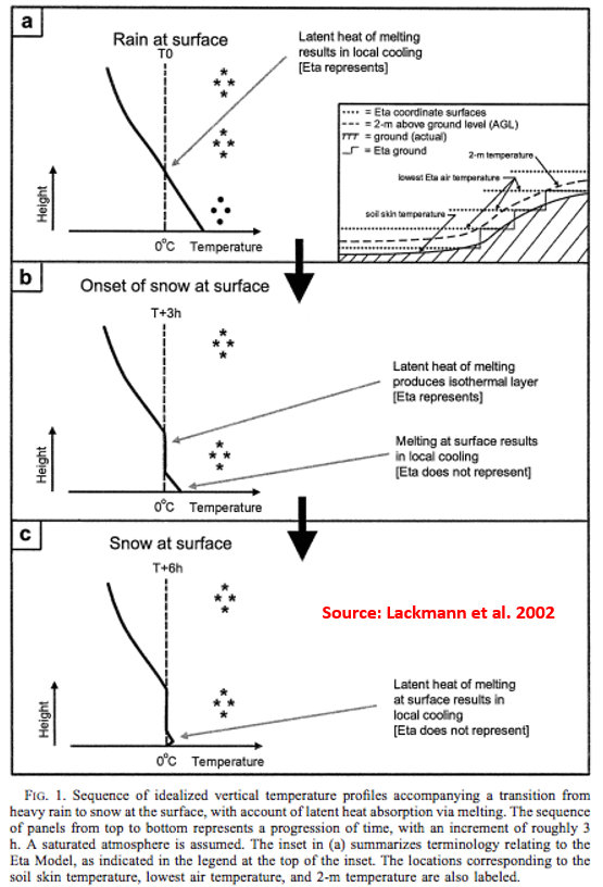
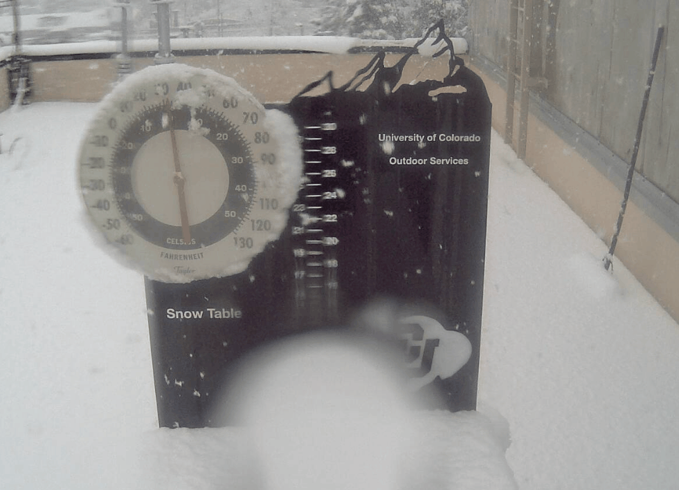
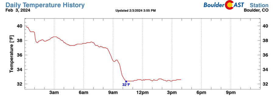
Don’t believe Professor Keah? You can see the result of this process in Saturday’s observed surface temperature timeline at our station. As the shield of heavy precipitation moved into Boulder around 8:30AM on Saturday, the temperature plummeted as melting snowflakes siphoned the heat out of the air. As soon as we got down to 32°F, the temperature flatlined the rest of the day. What happens at 32°F? Snowflakes stop melting. The only cooling mechanism we had was gone!
Another contested aspect of the forecast that was uncertain all along was whether or not a barrier jet would spawn on Saturday. As a reminder, barrier jets form when deep easterly flow is obstructed by the terrain for a prolonged period, causing low-level winds to turn towards the south near ground level. This mechanism forms a cold, dense “tube of air” near the base of the terrain which further enhances regional upslope motion. The tube of cold air essentially acts as an extension of the terrain eastward, allowing for heavy upslope precipitation to encompass the entire Front Range, even areas well away from the terrain.
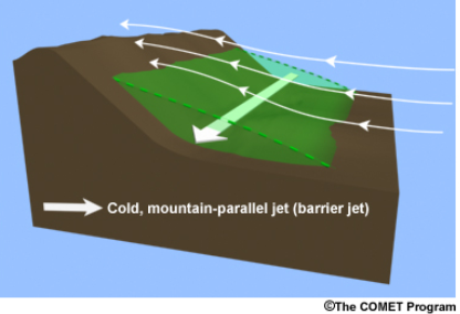
Leading up to the event, models remained in disagreement if a barrier jet would form and if it did, how strong it would be. A stronger, larger barrier jet would favor heavy precipitation for the entire Front Range. A weaker or non-existent barrier jet would instead favor normal upslope locations like Boulder and the far western Metro area for the heaviest precipitation. And remember, thanks to Keah, you know we needed those heavy precipitation rates to bring enough cooling to turn rain to snow!
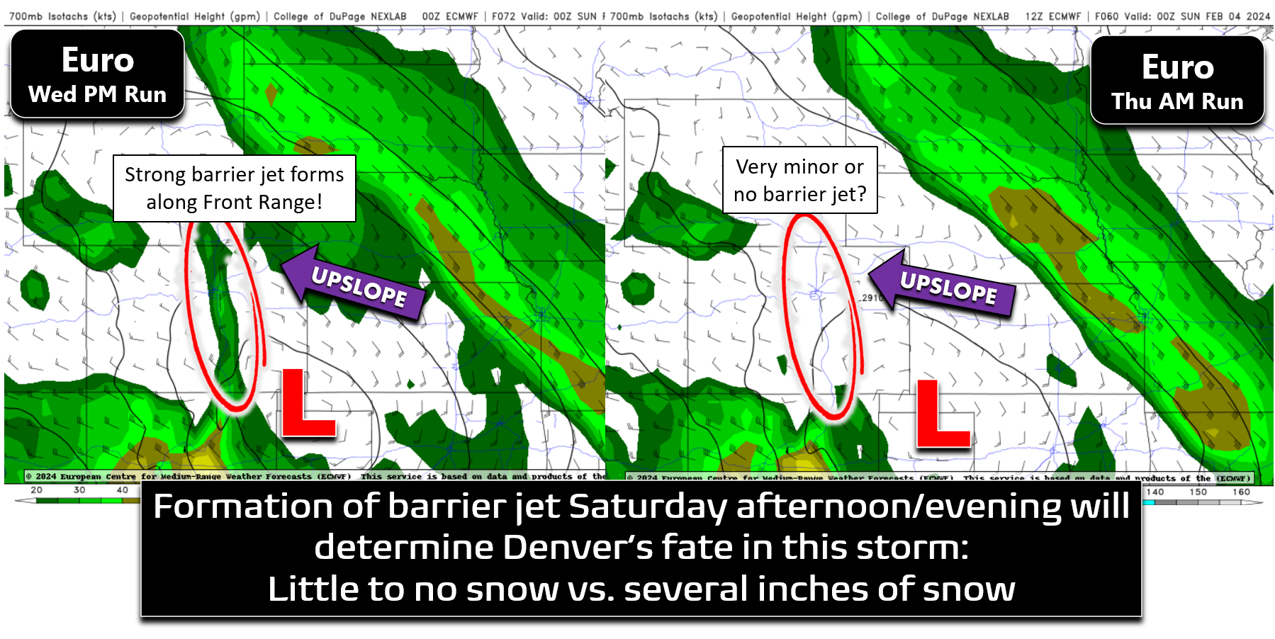
Ultimately, a rather weak barrier jet did end up forming on Saturday, as highlighted on the Platteville wind profiling radar data shown below. It persisted just a few hours and was only about 500 meters deep, but it was there!
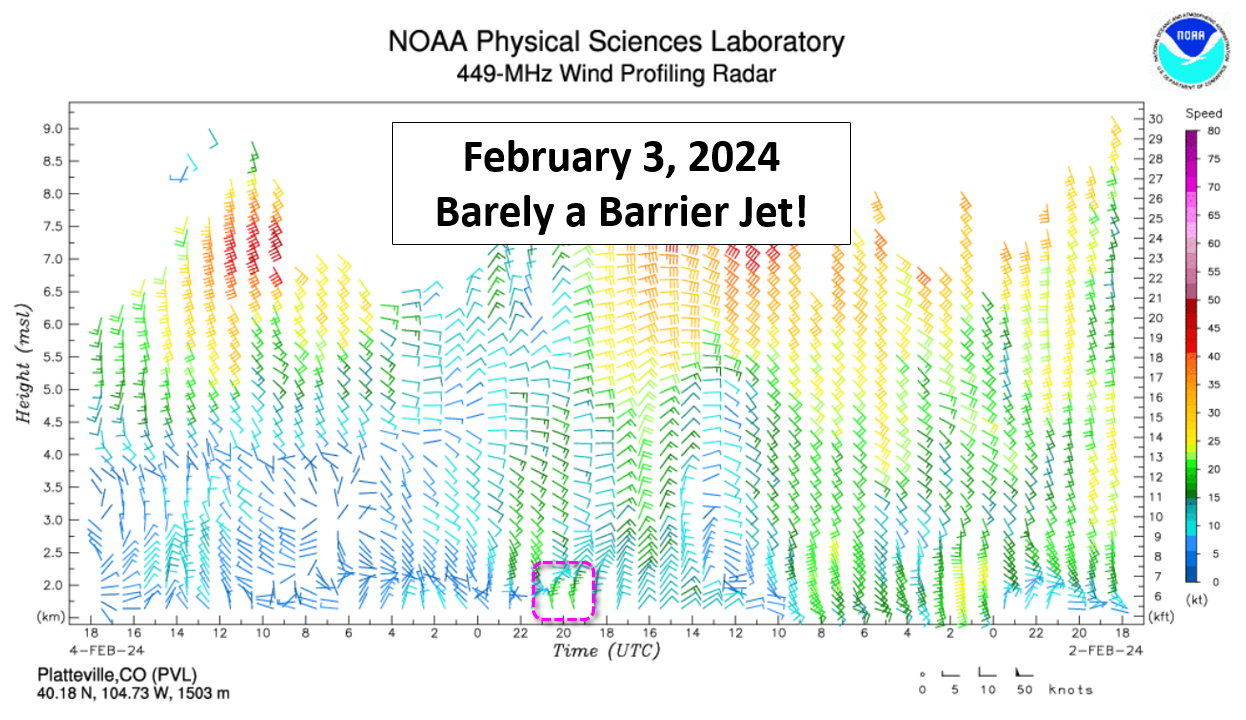
Based on the radar imagery from Saturday afternoon, it is likely the barrier jet that formed ran continuously from Wyoming to New Mexico, but was less than 50 miles wide banked up against the terrain (and it shriveled up quickly throughout the storm).
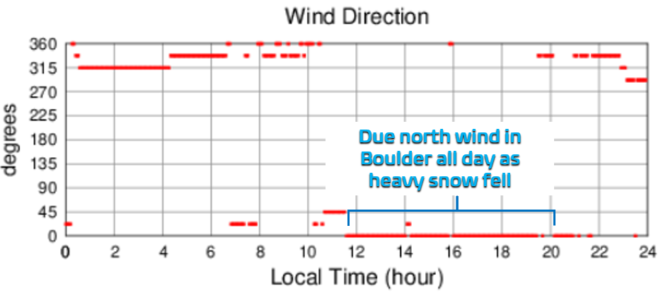
We can further confirm the likely existence of the barrier jet from wind direction data in Boulder — it was due north all day Saturday as heavy snow fell on the city. Located right at the base of the terrain, Boulder would see the strongest and longest lasting barrier jet. Several of our readers commented about the weird north wind blowing the snow around during this particular snow event. So often it will be easterly or northeasterly during our best snows (plain Jane upslope setups).
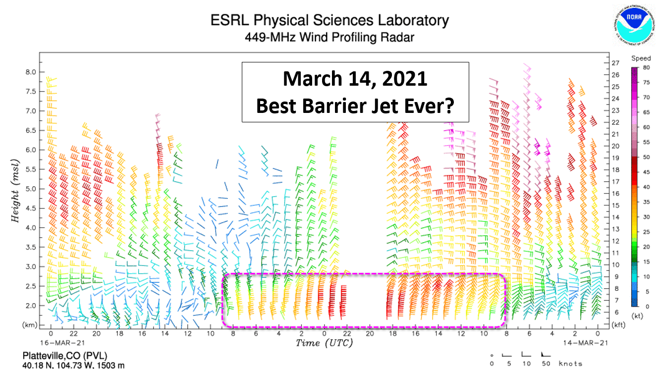
However, to demonstrate just how miniscule the barrier jet was with this storm, check out the one below which is from the epic March 2021 snowstorm that dumped more than 21″ of snow on Boulder and Denver. Now THAT is a barrier jet! It lasted nearly 24 hours, was 1500 meters deep and had winds near 50 MPH at its core!
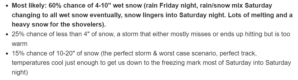
There’s way more we want to say about this amazing storm, but this post is already getting quite long, so we’ll cut it off here. We’ll be the first to admit that this wasn’t our best forecast outcome, but it also wasn’t our worst. Ironically we actually made our most accurate forecast for this particular storm well in advance. This is an excerpt from a Premium post about five days before it started raining and snowing where we commented on the likelihood of several specific outcomes:
In all seriousness though, there’s plenty to learn from this particular sloppy snow event, which has once again expanded our understanding of the type of winter storms which are even possible here in early February. This weekend’s storm had a lot in common with another super-soaker event that occured back in late December of 2022. With our climate continuing to warm, these “freak” spring-like winter storms may already be on their way to becoming a new normal for the Front Range. Thanks for reading and once again following along with us through Colorado’s craziest weather! We have a strange feeling this won’t be the last time El Niño delivers the goods this snow season…
Go Premium, get all the perks.
Daily Forecast Updates
Get our daily forecast discussion every morning delivered to your inbox.
All Our Model Data
Access to all our Colorado-centric high-resolution weather model graphics. Seriously — every one!
Ski & Hiking Forecasts
6-day forecasts for all the Colorado ski resorts, plus more than 120 hiking trails, including every 14er.
Smoke Forecasts
Wildfire smoke concentration predictions up to 72 hours into the future.
Exclusive Content
Weekend outlooks every Thursday, bonus storm updates, historical data and much more!
No Advertisements
Enjoy ad-free viewing on the entire site.
Spread the word, share Colorado’s crazy weather:


You must be logged in to post a comment.