After five straight sixty-degree days with quiet weather, things will turn cooler and unsettled for the weekend ahead as a sloppy El Niño storm moves through bringing a mix bag of precipitation to the Front Range. While there is still plenty of uncertainty in the exact outcome for Boulder and Denver, we discuss the latest forecast details including when the rain will start (including some rumbles of thunder), when and where it will change over to snow, which ski resorts will be rolling in powder this weekend, and most importantly — the expected moisture and snowfall amounts across the Front Range area. Let’s dive in!
At a Glance
- A strong Pacific weather system will bring a mix of rain and snow to the Front Range this weekend, with high uncertainty in the exact outcome for our area as Gulf of Mexico moisture (and warmth) gets infused into the storm
- There are a number of factors with this system that make it difficult to predict whether the Denver Metro area will see mostly rain or snow, such as the formation of a barrier jet and the timing of the precipitation and minimum temperatures.
- Our latest projection calls for up to 6 inches of snow in the Metro area (highest south and southeast, lowest around Boulder), with 2-10″ of snow in the Foothills.
- Heavy snow is in the works for the Mountains statewide, with most ranges receiving 8 to 20 inches of snow by Sunday afternoon. Skiers should expect great powder but difficult travel conditions getting there.

Go Premium, get all the perks.
Daily Forecast Updates
Get our daily forecast discussion every morning delivered to your inbox.
All Our Model Data
Access to all our Colorado-centric high-resolution weather model graphics. Seriously — every one!
Ski & Hiking Forecasts
6-day forecasts for all the Colorado ski resorts, plus more than 120 hiking trails, including every 14er.
Smoke Forecasts
Wildfire smoke concentration predictions up to 72 hours into the future.
Exclusive Content
Weekend outlooks every Thursday, bonus storm updates, historical data and much more!
No Advertisements
Enjoy ad-free viewing on the entire site.
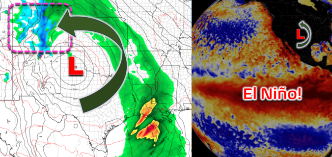
Finally a true El Niño storm, but will it be cold enough for snow?
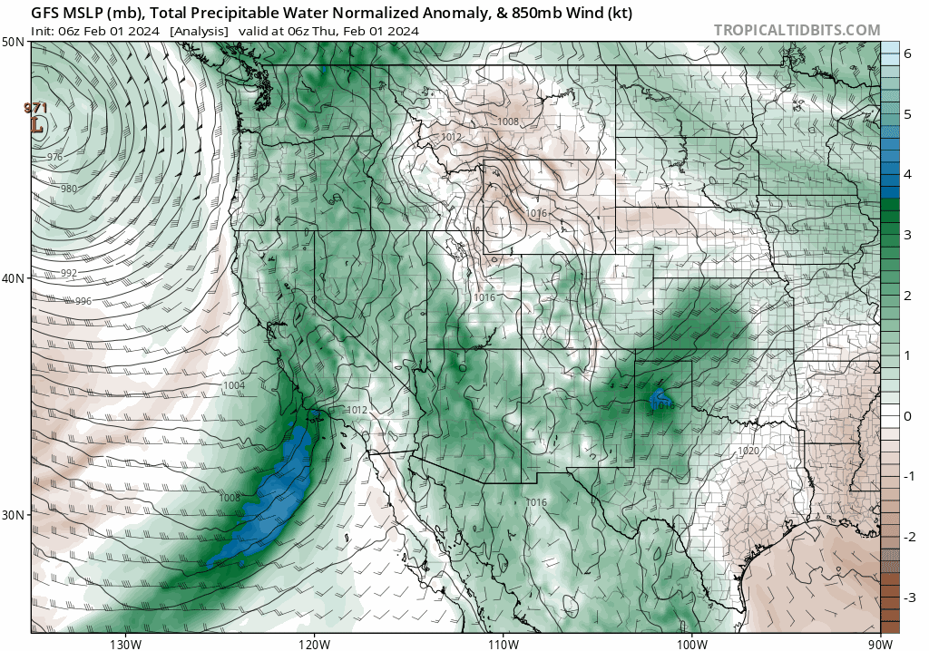
We’ve been tracking the incoming strong Pacific storm all week long, hoping that models would come into better agreement on just how this complex and sloppy storm would play out across the Front Range. In retrospect, the broader atmospheric pattern coming together across the southern Rockies has been surprisingly well-advertised this week, with very little change noted over the last five days in the models. That is, a trough containing a remnant atmospheric river comes ashore in California, moves across the Four Corners and then explodes into an expansive closed-low pressure over far northeastern New Mexico. That series of events has been expected for almost a week now.
As the storm intensifies and grows to our south Friday night through Saturday, the remnant atmospheric river will further infuse with juicy Gulf of Mexico moisture wrapping into the system from the east. You can see things coming together in the latest GFS total column moisture anomaly forecast animation below.
While the forecast may sound easy in theory, the devil has really been in the details this week, with this system in particular proving to be an extremely challenging forecast. Global weather models have been all over the place with their predictions for how much and what type of precipitation makes it into the Front Range this weekend. Yes, shockingly in early February we have a system that doesn’t have the needed cold air to give us guaranteed snow. Discerning whether this would ultimately be a rainstorm or a snowstorm has been a struggle. At times, some models have showed as much as two feet of snow falling in the Denver Metro area — these outlying early model predictions are part of the reason hype has been incubating for this storm. However, that was never the expected outcome, at least from our team’s view. Comically, a nearly equal proportion of model runs this week also showed essentially zero precipitation for us this weekend. That was also never an expected outcome.
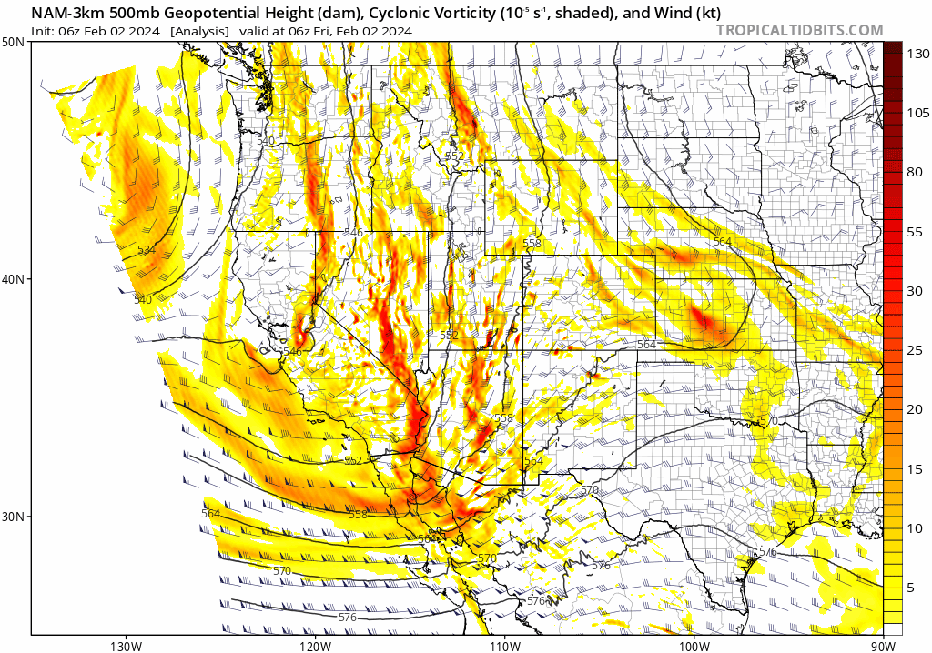
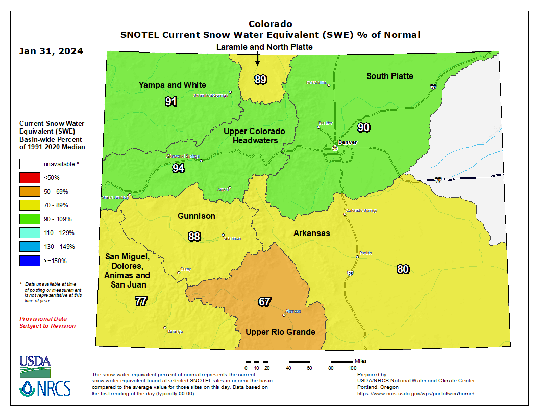
As of Friday morning, we still are seeing plenty of uncertainty in the models, but things are starting to come into better focus with confidence growing for a mix of rain and snow in the coming days across the Front Range. The easiest forecast this weekend was always for the Mountains which will see high odds of heavy snow this weekend as they are able to catch both the Pacific moisture coming from the southwest and the Gulf moisture flowing in from the east. Snow showers will increase across the Mountains statewide on Friday, with moderate to heavy snow possible late Friday night all the way through Sunday morning. Southern Colorado will do best initially under southwest flow Friday into early Saturday, but northern Colorado will eventually be favored by northwest flow Saturday into early Sunday. Most mountain ranges above 10000 feet can expect 8-20″ of snow this weekend — great news considering every single river basin statewide is currently reporting below normal snowpack.

The most challenging aspect of the forecast all along has been discerning the outcome for the Denver Metro area which will be right on the cusp of rain and snow throughout the duration of the storm. There’s no discernible cold front associated with this system, at least across our area. As the surface low develops in southeast Colorado early Saturday, weak northerly flow will set up over the Front Range leading to a slight cooling. However, this probably doesn’t get us cold enough to see snow on its own…
Additional cooling will be supplied by a potential barrier jet, which may or may not develop Saturday afternoon into the nighttime. As a refresher, barrier jets form when deep easterly flow is obstructed by the terrain for a prolonged period, causing low-level winds to turn towards the south near ground level. This mechanism forms a cold, dense “tube of air” near the base of the terrain which further enhances regional upslope motion.
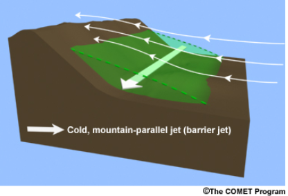
We haven’t really seen a highly-productive barrier jet bank up against the Continental Divide since the monster March 2021 snowstorm that dumped more than 20″ of snow on Boulder and Denver alike. However, barrier jets don’t necessarily tend to favor Boulder, as upslope over Boulder actually decreases as the main uplift barrier instead shifts eastward towards Interstate 25. The tube of cold air essentially acts as an extension of the terrain eastward.
Models have remained largely mixed on whether a barrier jet will form on Saturday, but we believe it is a key aspect of the forecast. The development of this low-level jet parallel to the terrain will allow for additional cooling via advection from the north, and it will also enhance precipitation rates which would cause further cooling (from melting, evaporation and dynamics).
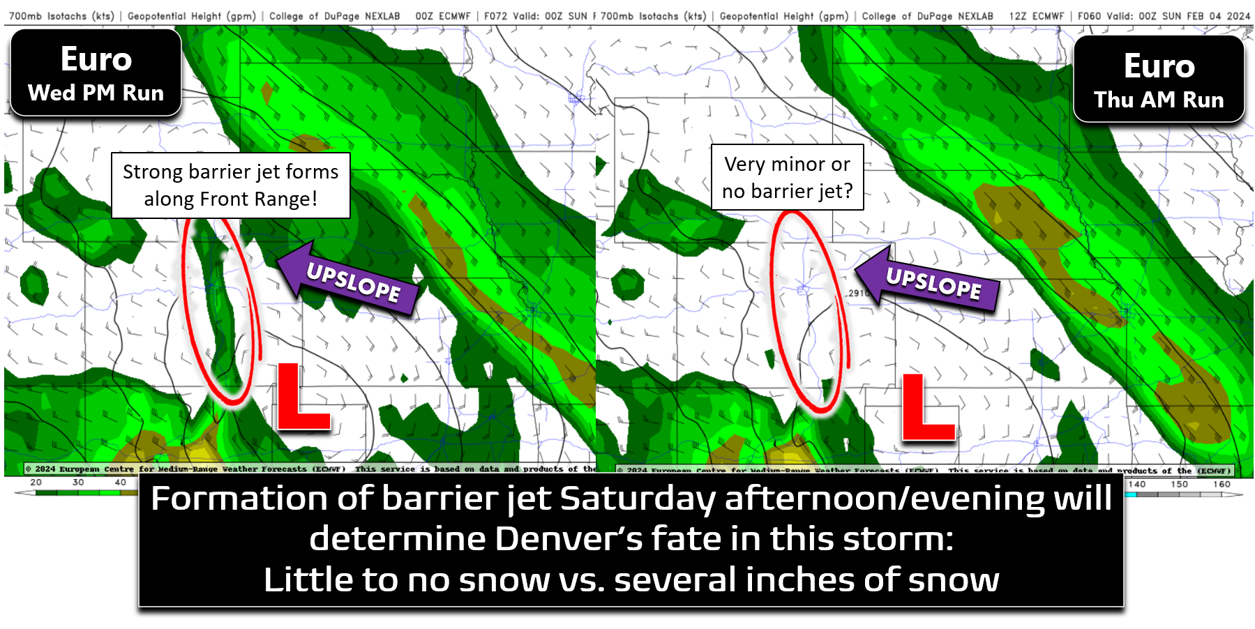
Right now, we believe it’s roughly a coin flip on whether this feature actually forms, even being so late in the game, but we are leaning more towards the barrier jet showing up sometime Saturday afternoon or evening in some regard. Here are the two potential outcomes that we see now:
- (60% chance) Barrier jet forms and is somewhat strong: Spotty rain showers Friday night into early Saturday will become more widespread by late Saturday morning or afternoon. As the barrier jet ramps up, precipitation rates will take off with rain changing to wet snow across most of the Metro area. There will be a band of heavy snow possible along and just east of I-25 with snowfall rates of 1-2″ per hour. Temperatures would drop down close to freezing by late afternoon and evening allowing for several inches of slushy accumulation — up to 6 inches in the Metro area, with locally higher totals possible under the most persistent banding (up to a foot southeast of Denver and across Palmer Divide). This situation complicates the forecast for Boulder specifically, with the potential of ending up too far west of the best lift and in a regime where some downslope may come in off the Foothills drying things out. A strong barrier jet would certainly favor Denver, Aurora and DIA much more so than Boulder.
- (40% chance) Barrier jet doesn’t form or does but is weak: Spotty rain showers Friday night into early Saturday will remain intermittent through the day on Saturday as well. Temperatures are never able to cool enough and precipitation type will be mostly rain or a very wet mix of rain/snow with minimal accumulation across the Metro area — a trace to 3 inches. The storm still delivers 0.5″ of moisture or better, but snowflakes are hard to come by across the flatlands.
All things considered, our confidence is still somewhat low regarding which scenario unfolds Saturday. The latest GFS now has a strong barrier jet forming with 1″+ of moisture dumping on the Denver Metro area, most of that being rain before noon on Saturday with a change-over to snow in the afternoon and evening. On the contrary, the Euro has backed off on its barrier jet formation, now with almost no signal present and only around 0.5″ of moisture for the Metro area. These aren’t consistent model trends, though, as both global models have been highly volatile this week with their respective stances flip-flopping seemingly every day — including today!

The short-range HRRR model is just now starting to get a look at the entire storm and it does indeed show the formation of a barrier jet and a persistent band of heavier precipitation along or just east of I-25 beginning Saturday late afternoon lingering for more than 12 hours into Sunday morning. Notice the north-south oriented band of precipitation that persists throughout the back half of the simulated radar animation below. If this setup truly does verify, some of the harder hit areas east of I-25 could be on the hook for greater than 1.5″ of moisture out of this storm, which could translate into locally 6-12″ snow totals.

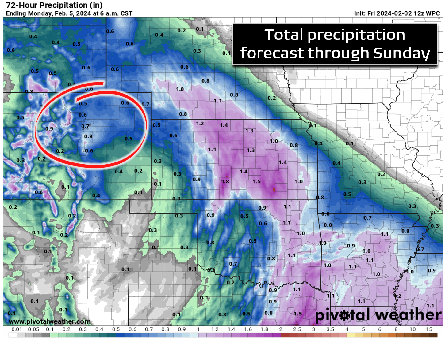
However, based on all the model guidance, a more representative forecast would be for anywhere from 0.5 to 1.1″ of moisture to fall between now and Sunday morning. The Weather Prediction Center’s precipitation forecast below aligns closely with our current thinking on the most likely moisture dump from this system.
In regards to snowfall amounts, this likely won’t be a hugely impactful snow-producer for the Metro area as temperatures will be just a bit too warm overall. Yes, there will certainly be some snow in many areas Saturday afternoon through Sunday morning, but there will also be lots of melting with temperatures near freezing or even a few degrees above throughout. Travel should remain mostly okay, but keep an eye out for slush-covered roadways in the heaviest bursts of snow (if those verify). All things considered, shown below is our snowfall forecast map for this event, including all snow falling through Sunday morning. Snowfall totals will be lowest around Boulder and Longmont where temperatures will be warmest and downslope may spoil things Saturday evening (nothing to 3″). Most of us should see between a trace of snow and 6″ of slush on the grass by the time things wrap-up Sunday morning. The best chance of receiving those more significant soupy snow accumulations will be south and southeast of Denver Saturday evening into Sunday morning. We once again reiterate that confidence is still rather low on snow amounts below 6500 feet elevation — we definitely expect some busted and booming snow totals around the region! In the Foothills above 6500 feet, anywhere from 2-10″ of snow will fall from this storm, with the greatest amounts in the southern Foothills and for areas above 8000 feet.

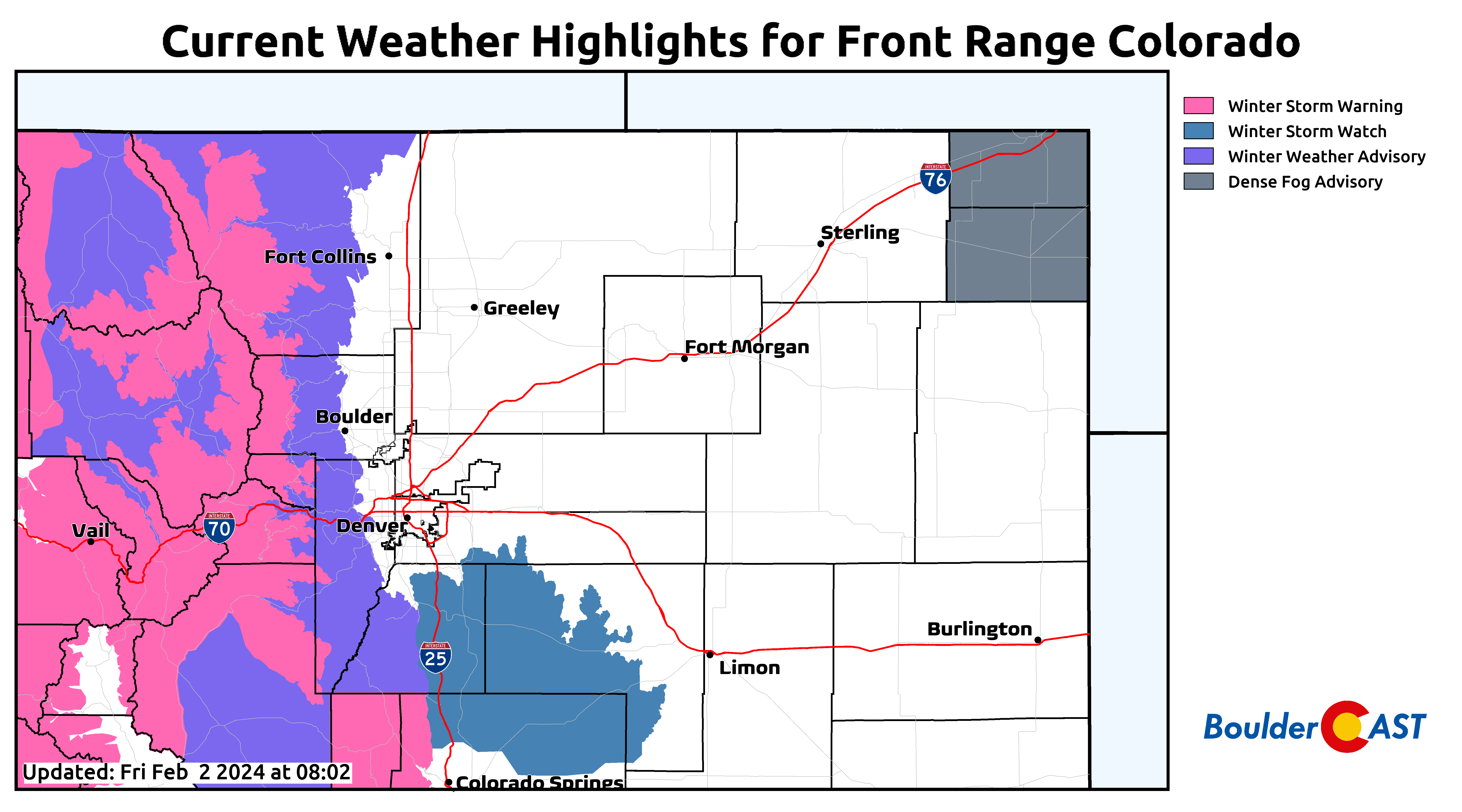
Winter Storm Warnings are widespread throughout the Mountains, with Winter Weather Advisories posted in the Foothills and Mountain valleys. The Palmer Divide is likely to see 4-10″ of snow as well, so plan for snowy travel along I-25 between Denver and the Springs this weekend.
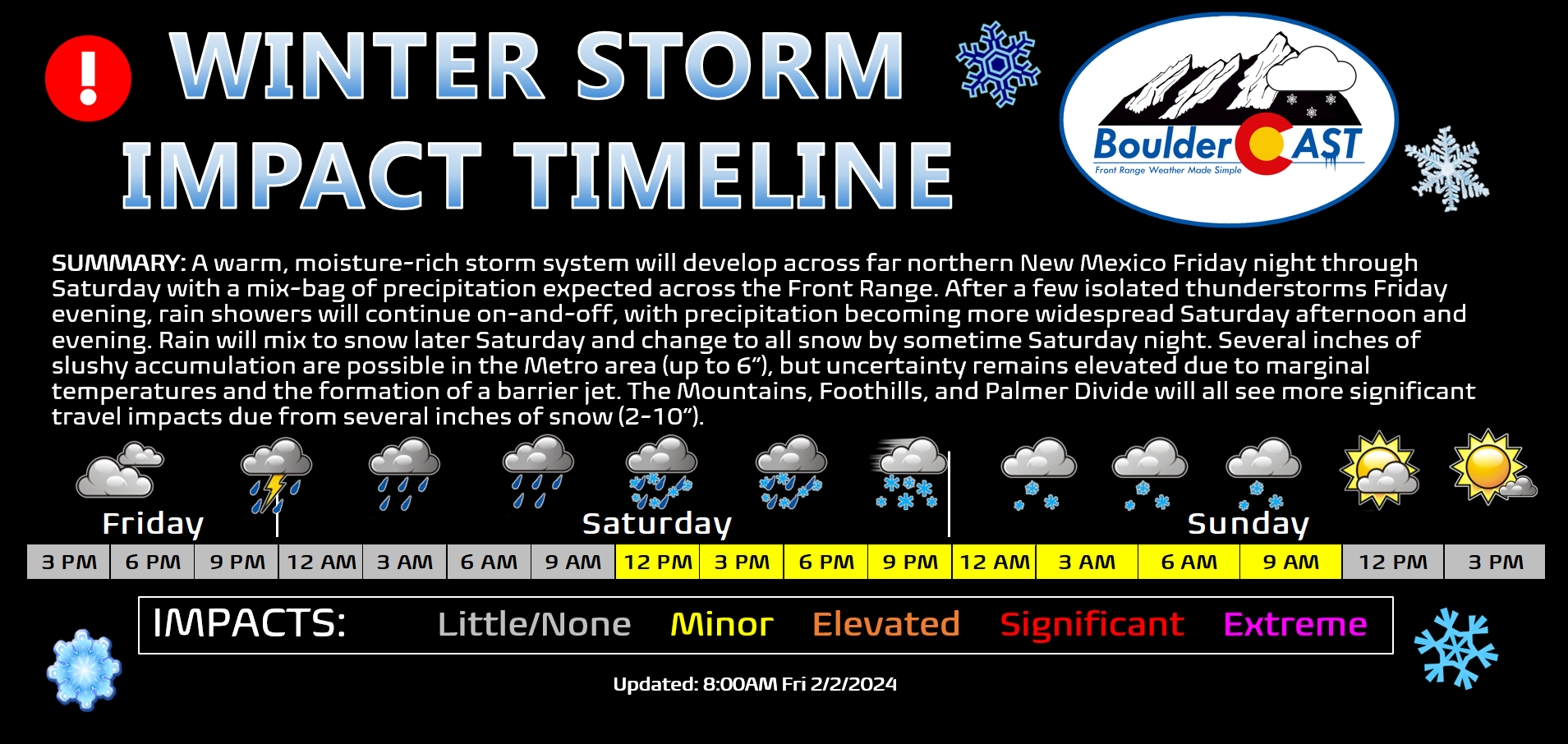
Here’s a breakdown of how we believe things will most likely play out this weekend:
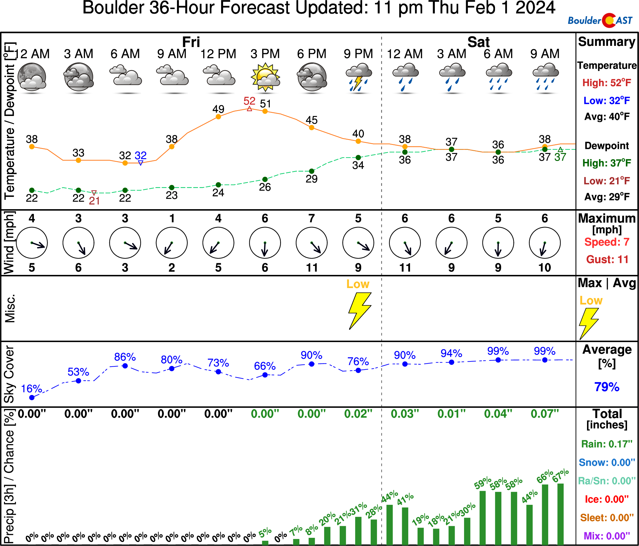
- Friday through Friday night: A cooler day overall with highs around 50 degrees under gloomy overcast skies. Snow increases in the Mountains with a few spotty rain showers developing over the Metro area by evening. There is some instability around, so isolated rumbles of thunder are not out of the question during the evening and overnight. Snow levels only drop down to around 6000 feet overnight with precipitation type staying all rain below that.
- Saturday: Spotty morning rain showers become more widespread through the day, eventually mixing with snow through the afternoon and evening. Where it does snow, little accumulation is expected during the daylight hours as temperatures will be above freezing everywhere. A high temperature in the upper 30s should occur in the morning to midday hours before we cool off slightly heading into the late-day period.
- Saturday night: Temperatures slowly drop into the low to middle 30s and it gets cold enough that most areas change-over fully to snow, with some heavy snow along and east of I-25. Travel could become slick overnight, especially along and east of I-25 where the threat of heavier snow and colder temperatures are greater.
- Sunday: Some snow may linger in the morning, but things clear out by midday. Highs in the low to middle 40s by afternoon.
That’s all we have for now. While this storm won’t quite live up to the semi-famous Groundhog Day 2016 snowstorm from eight years ago, this weekend will offer up a potent and surprisingly sloppy storm — something that hopefully becomes more common as we head into the spring season with El Niño still roaring in the eastern tropical Pacific. Be sure to follow us on Twitter, Facebook, and Threads for more timely updates as this messy mix of rain and snow unfolds across the Front Range this weekend. Keep your fingers crossed that this still uncertain storm delivers the goods — if not snow, at least in terms of moisture — we definitely need it!
Get BoulderCAST updates delivered to your inbox:
Go Premium, get all the perks.
Daily Forecast Updates
Get our daily forecast discussion every morning delivered to your inbox.
All Our Model Data
Access to all our Colorado-centric high-resolution weather model graphics. Seriously — every one!
Ski & Hiking Forecasts
6-day forecasts for all the Colorado ski resorts, plus more than 120 hiking trails, including every 14er.
Smoke Forecasts
Wildfire smoke concentration predictions up to 72 hours into the future.
Exclusive Content
Weekend outlooks every Thursday, bonus storm updates, historical data and much more!
No Advertisements
Enjoy ad-free viewing on the entire site.
Enjoy our content? Help us out and give it a share:


You must be logged in to post a comment.