
Rain and some snow have already begun across the Front Range, but as of writing Saturday morning, the exact outcome of the moisture-infused winter storm moving in now remains in question. We provide the latest forecast (nowcast?) for rain and snow unfolding now, including some minor adjustments to our snowfall forecast map and storm timeline. Brace for a soggy and snowy Saturday!
At a Glance
- Winter Storm Update: In this post, we provide a timely update for a winter storm that is bringing heaps of rain and snow to the Front Range Colorado on Saturday
- Precipitation Distribution: A subtle change in the regional weather setup has led to more Gulf moisture being pushed into the terrain, resulting in higher precipitation amounts for the western Denver Metro area, Boulder and the Foothills, and lower amounts for areas east of I-25.
- Rain/Snow: Predicting the exact location and timing of the change-over from rain to snow is challenging, as it depends on the intensity of the precipitation, the surface temperatures, localized downslope, and a potential convergence of winds that could produce very heavy snowfall rates in some areas. Overall, the forecast is looking snowier than it did previously.
- Snowfall Forecast: We provide our final snowfall forecast map, storm travel timeline, and confidence levels for different regions, with the highest snow totals expected in the lower Foothills (5-15 inches) and the lowest totals in the northern Denver Metro area (just a dusting to 4 inches)

Go Premium, get all the perks.
Daily Forecast Updates
Get our daily forecast discussion every morning delivered to your inbox.
All Our Model Data
Access to all our Colorado-centric high-resolution weather model graphics. Seriously — every one!
Ski & Hiking Forecasts
6-day forecasts for all the Colorado ski resorts, plus more than 120 hiking trails, including every 14er.
Smoke Forecasts
Wildfire smoke concentration predictions up to 72 hours into the future.
Exclusive Content
Weekend outlooks every Thursday, bonus storm updates, historical data and much more!
No Advertisements
Enjoy ad-free viewing on the entire site.
A subtle, yet crucial change in the regional weather setup Saturday
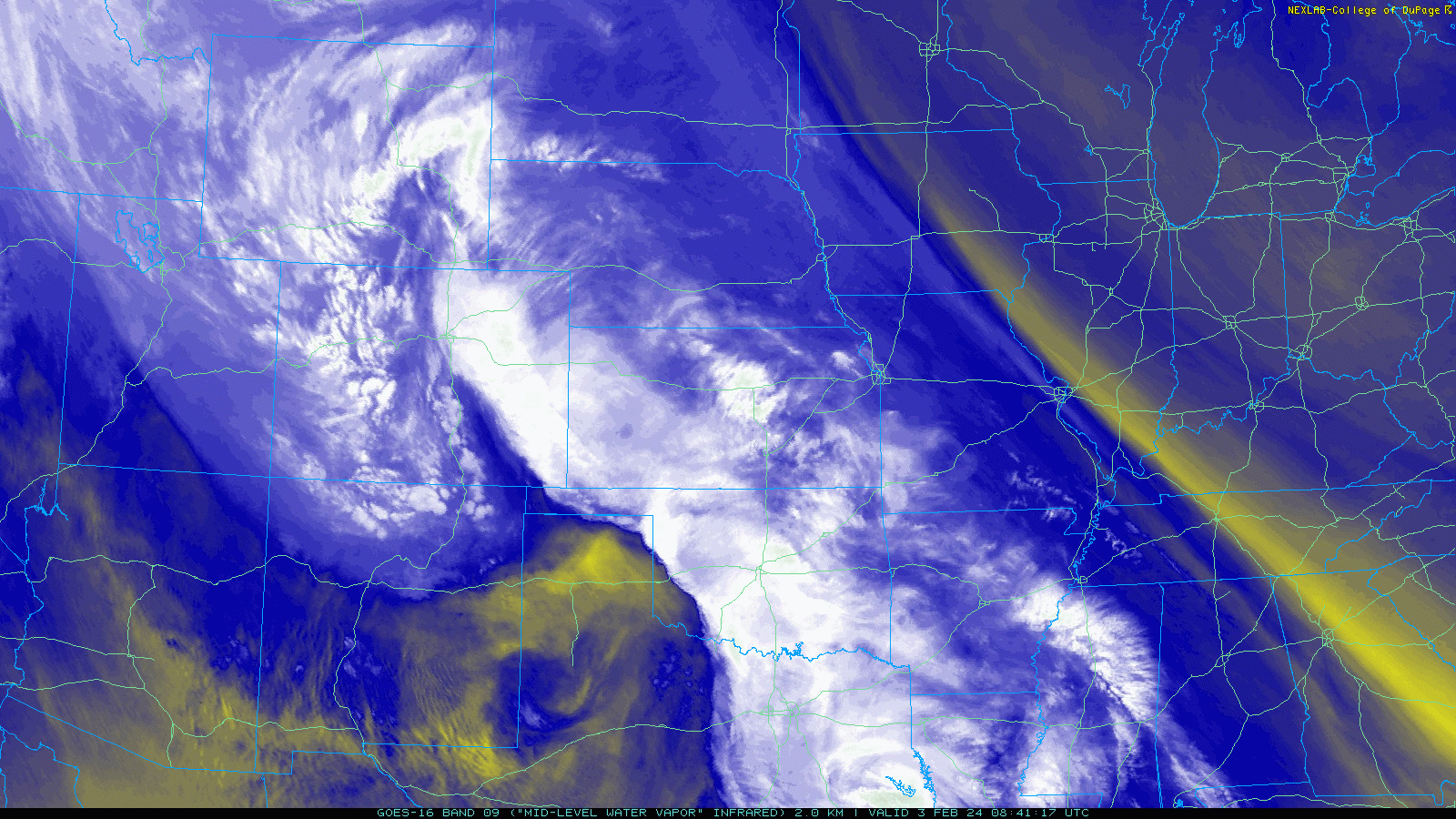
All signs now point to a significant precipitation event about to unfold across portions of the Front Range on Saturday as deep moisture from the Gulf of Mexico gets thrusted north and then west into our terrain by a developing large and closed low pressure in southeast Colorado. The latest GOES-East water vapor satellite imagery from Saturday morning is already looking impressive, and frankly, also a bit worrying. A continuous faucet of moisture is roaring into the Front Range all the way from the Gulf. This doesn’t have quite enough travel distance to be considered an official atmospheric river, but let’s call this one an atmospheric creek!
Over the last 12 to 18 hours, we’ve started to see the forecast models move away entirely from the barrier jet solution towards one that is similar, yet crucially different. Without the barrier jet forming to “block” the copious moisture from continuing westward, that moisture will instead slam directly into our terrain throughout Saturday leading to a deluge of precipitation for locations in and near the Foothills in the morning to afternoon hours. There are some models which show a strong line of convergence setting up over the Metro area Saturday afternoon into the evening — with drier downslope winds coming off the terrain to meet up with extremely moist upslope flow wrapping in with the storm from the east. Where these two opposing winds come together could produce an area of strong lift, similar to the diagram below.
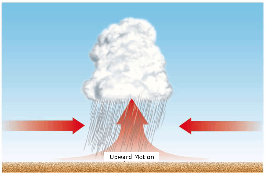
Diagram showing how low-level convergence leads to lift
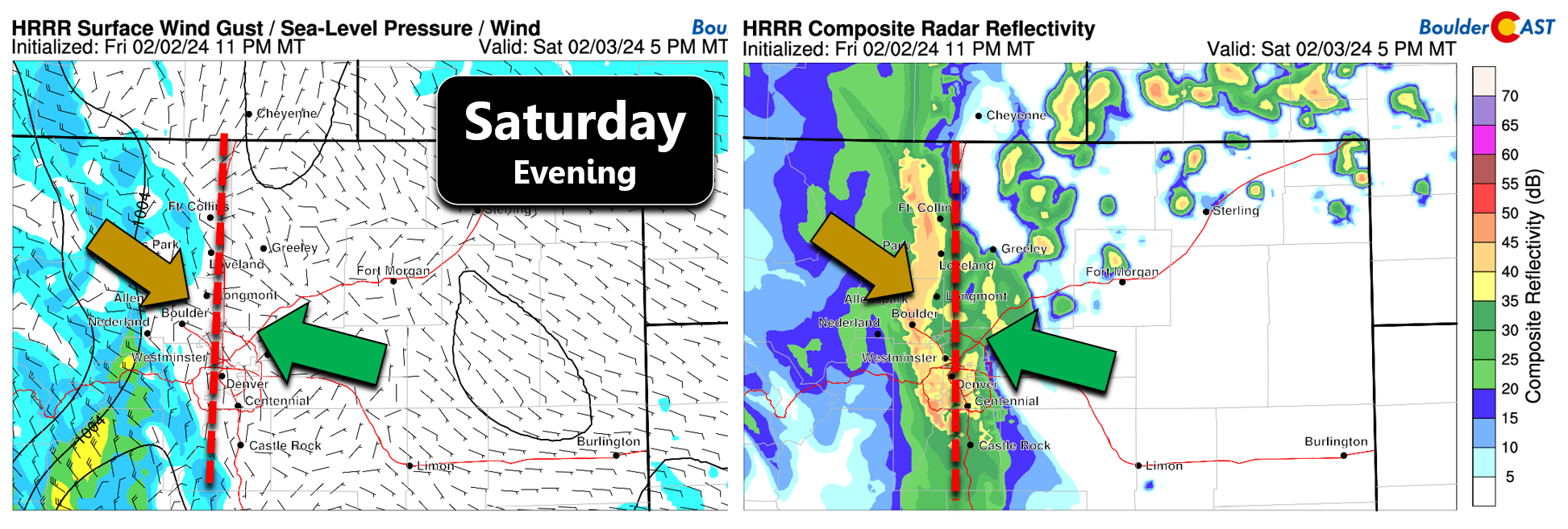
The result will be a very heavy north-south oriented band of precipitation later on Saturday. For example, below is the HRRR surface wind forecast and radar for 5PM Saturday evening. This particular model has the convergence line stretching from Fort Collins to Boulder and Golden. The line will likely be shifting in time, but it will be slow moving. Inside this band, precipitation rates could approach 0.25″ per hour of liquid. In areas where it is cold enough for snow, that would equate to 2″+ per hour snowfall rates — extremely heavy snowfall. A very similar convergence setup actually occurred in the Groundhog Day 2016 snowstorm which dumped 19″ of snow in Boulder. That storm was a lot colder than today’s event, but inside the core of its heaviest convergent snow band, we measured snowfall rates close to 4″ per hour for a few hours in a row! The exact location where this band may form will be challenging to predict indeed, but will have large implications on the forecast. In case you are wondering, these lines of convergence don’t always favor Boulder in winter storms — sometimes they can instead hit downtown Denver or elsewhere.
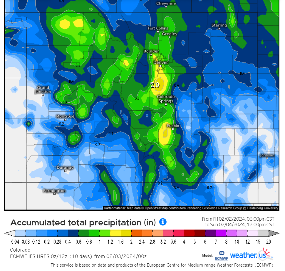
This subtle forecast change has led to huge implications on the amount and distribution of precipitation across the Front Range from this storm. Without the barrier jet to “spread the wealth” around, the western Denver Metro area, including Boulder and the Foothills, is now much more likely to receive over 1″ of moisture today. Areas east of I-25 are now more likely to see lower totals, but still impressive ones. The HRRR’s predicted precipitation amounts are below.
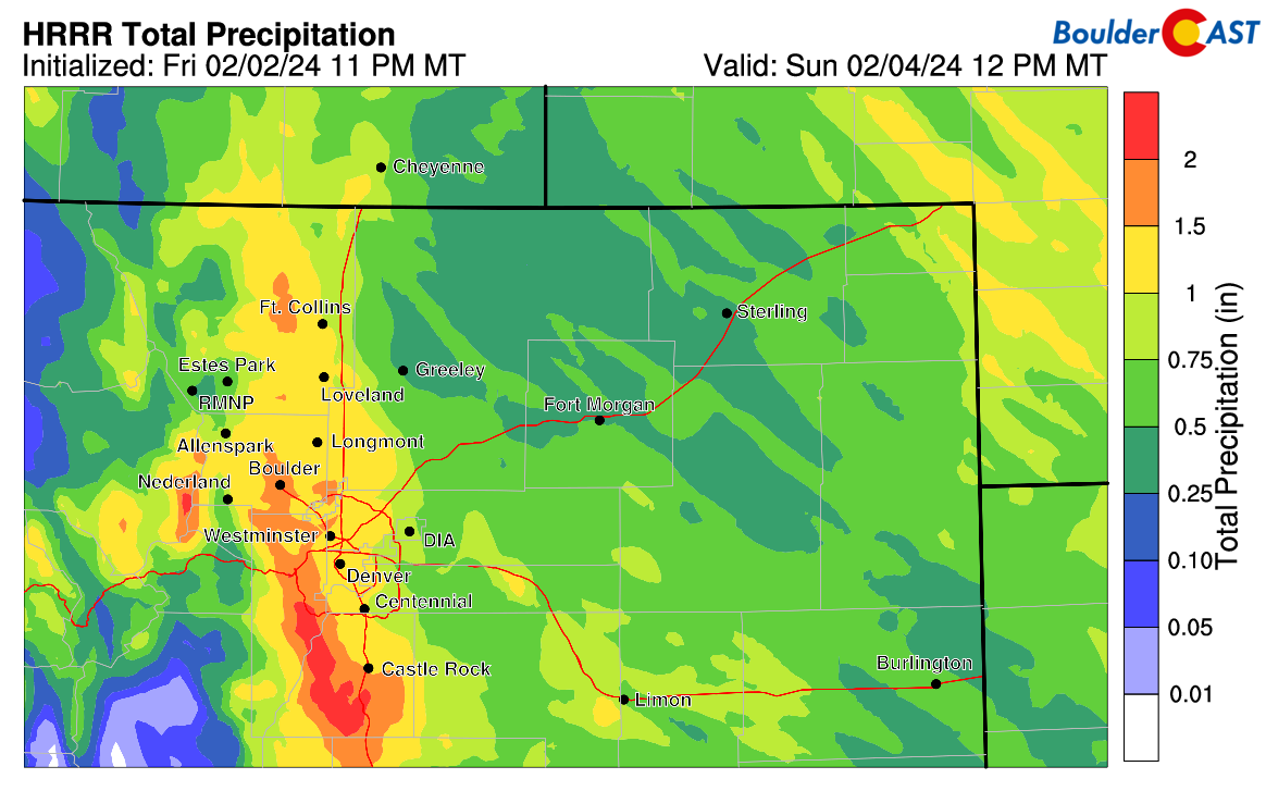
The HRRR is one of the more bullish model solutions right now, but its trend has been clear since Friday afternoon and it is generally mimicked across the breadth of other model offerings. For example, the Euro model has once again risen up, now closely mirroring the HRRR solution, at least in our immediate area, with over 1″ predicted for Boulder and Denver.
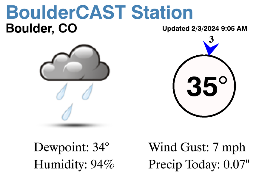
Despite the increased likelihood that this storm will deliver on the high-end for moisture, surface temperatures remain a vivacious point of contention — something that was always a concern for this event. The infusion of Gulf of Mexico moisture also comes with plenty of warmth, giving us a rare early February forecasting nightmare for precipitation type in the Front Range! We are indeed starting out too warm for snow across the lower elevations Saturday morning. As of 9AM, it is 35°F at our station in Boulder with a completely saturated lower atmosphere and a dew point of 34°F.
As we’ve been harping on all along, there is no cold front coming, and now there’s no barrier jet. The one aspect of the storm that can still provide enough cooling for a change-over to snow will be the extreme precipitation rates inside the core of that heavier snow band mentioned earlier, as the millions of melting of snowflakes will cause cooling in the lower atmosphere. So the exact location of the hard-to-predict convergence band will be critical in how much sloppy snow piles up today and where. Outside of that doozy of a band, precipitation rates will be somewhat lighter and as a result, temperatures will be warmer and stay a few degrees above freezing or warmer.

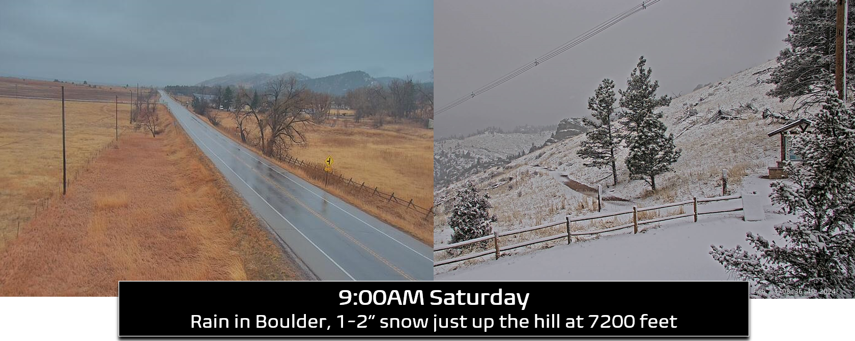
This situation at hand, even in this final hour with a chilly rain falling already, leaves us with a very challenging forecast across all of the lower elevations. Much of the Denver Metro area is likely to see rain change to wet snow Saturday but with minimal accumulation due to the warm air and ground temperatures (less than 4″ of snow for most). However, rain will change-over to big snowflakes inside the heavier bands with slushy snow accumulations potentially adding up quickly as melting is out-paced. It’s already raining or drizzling across the entire Front Range as of 9AM Saturday (and some snow falling in the heavier bursts), with all snow falling in areas above ~6500 feet.
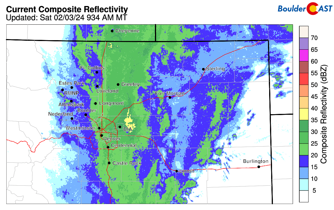
Current radar is impressive with a deluge of precipitation to the east that is headed this way — it will only intensify as it interacts with the terrain. We are definitely in for a soggy, sloppy, and snowy Saturday!
Expect widespread rain changing to snow Saturday morning across the entire Metro area (with all snow in the Foothills) as moist mid-level upslope strengthens. As we head into the late morning and afternoon, flow aloft will become more northerly or northwesterly leading to slight cooling over northern Colorado. This, combined with the potential north-south oriented convergence band somewhere west of Interstate 25 will lead to many areas changing over to snow, including locally heavy snowfall, still with lots of melting though on the Plains. The Foothills will be getting hammered late morning through early evening by prolonged heavy snow. Travel is not recommended this afternoon in the higher terrain where 1-2″ per hour snowfall rates will be common. Snow will taper off through the evening hours, fully ending across the region by midnight Saturday night. Unfortunately, this entire storm system has sped up a bit. Precipitation is arriving earlier this morning, but it also will end more quickly this evening. Thus, there will be almost no overlap between sub-freezing temperatures and precipitation in the Metro area. Yes, there will be lots of snowflakes falling during the day, but there will also be plentiful melting. Accumulating more than a couple inches will only occur in areas where the heaviest bands linger for several hours. This is an exceptionally tricky forecast with the blurred line between rain and snow so closely straddled.
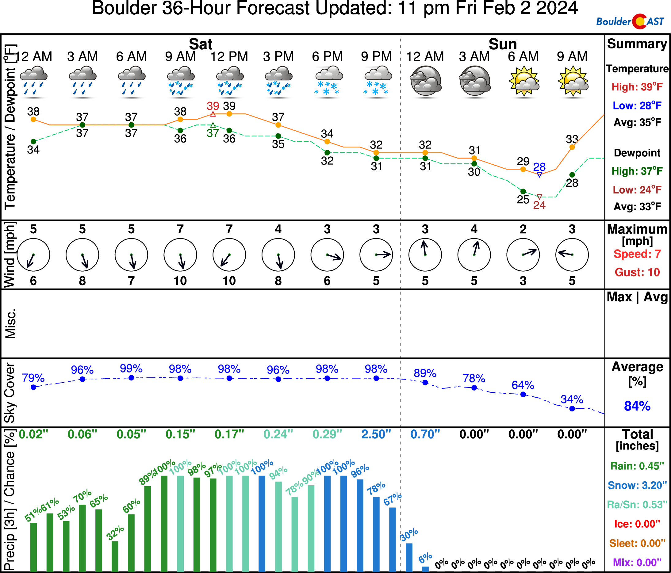
All in all, we’re not changing our overall snowfall forecast map much — just rearranging things a bit for the lower elevations (see below). We still believe most of the Boulder-Denver area will receive between a trace and 3″ of snowfall today. However, locally higher totals of up to 6″ are possible in the southern and western Metro area where banding is more likely and the neighborhood elevations are slightly higher (and thus cooler). What snowfall ultimately sticks on the ground will be significantly less than what falls! We also believe the area around Boulder may end up catching some downslope off the terrain which could keep things warmer and allow for less accumulation. This could be an issue from Boulder, to Longmont to Fort Collins. The biggest change in today’s update is that we have bumped up snow totals in the lower Foothills (6500 feet to 8000 feet elevation) which are most probable to get hit hardest by heavy snow during the day Saturday into Saturday evening, more than a foot in some cases.

Our storm travel timeline has not changed much either with mainly just slushy roadways out there. We expect just Minor impacts from this snow event — mostly regarding the slush-covered roadways in the heavier snow bursts. Keep in mind, this impact timeline is for the Boulder-Denver area only. Travel will be worse with Elevated to Significant impacts in the Foothills, Palmer Divide, and Mountains during this entire timeframe.
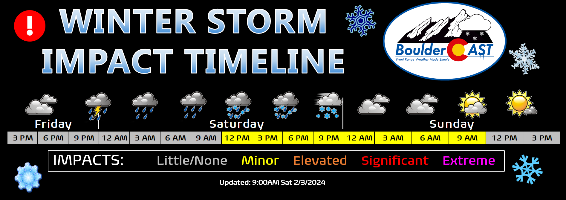
The higher terrain has been upgraded to Winter Storm Warnings where colder temperatures will lead to greater snow totals and travel impacts. Within the last hour, the Metro area has been included in a Winter Weather Advisory for minor travel impacts through the afternoon and overnight ahead.

Here’s our final thoughts on the storm as things ramp up:
- Widespread rain Saturday morning across the lower elevations will mix with and change to wet snow at times. All snow in the Foothills!
- Snow will become more widespread from midday into early evening, with locally very heavy snow occurring at times in some of the stronger bands. Areas around Longmont, Greeley and Fort Collins may stay a tad warmer with more rain/snow mix than snow.
- Temperatures fluctuate between 32°F and 37°F during the day Saturday leading to plenty of melting for whatever snow falls
- Snow tapers off through the evening, fully ending before midnight for most of the area. Roads may become icy overnight as temperatures drop slightly below freezing and freeze wet roads
- We still have fairly low confidence for snow totals across the Boulder-Denver area, but a dusting to 6″ is favored, highest south and southwest
- High confidence for snow totals across the Foothills and Palmer Divide (5-15″)
That’s it for this final “nowcast” update before this impressive storm fully unleashes on us. Be sure to follow us on Twitter, Facebook, and Threads for more timely updates as this messy mix of rain and snow unfolds across the Front Range today. Happy rain/snow day!
Get BoulderCAST updates delivered to your inbox:
Go Premium, get all the perks.
Daily Forecast Updates
Get our daily forecast discussion every morning delivered to your inbox.
All Our Model Data
Access to all our Colorado-centric high-resolution weather model graphics. Seriously — every one!
Ski & Hiking Forecasts
6-day forecasts for all the Colorado ski resorts, plus more than 120 hiking trails, including every 14er.
Smoke Forecasts
Wildfire smoke concentration predictions up to 72 hours into the future.
Exclusive Content
Weekend outlooks every Thursday, bonus storm updates, historical data and much more!
No Advertisements
Enjoy ad-free viewing on the entire site.
Enjoy our content? Help us out and give it a share:


You must be logged in to post a comment.