We got our first taste of 60-degrees in the New Year on Sunday and those sixties will continue through much of the week ahead as high pressure dominates our weather. However, as you’ve probably heard already, a potent Pacific storm is looming in the extended with a slew of impacts expected across the Front Range during the upcoming weekend. Uncertainty is unsurprisingly quite high being six days out, but early indication does show a good chance for a significant accumulation of heavy wet snow in the Metro area following a period of rain. Read on as we discuss not only the beautifully warm and sunny weather this week, but also the cold and snowy stuff brewing for the weekend.
This week’s highlights include:
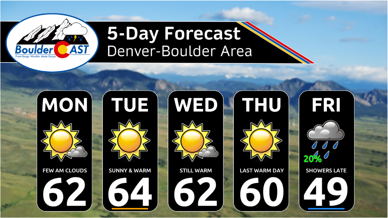
- A slow-moving and broad ridge of high pressure will dominate our weather through Thursday with daytime highs in the low to middle 60s and sunshine expected in the Metro area
- Temperatures will cool on Friday ahead of an approaching storm with more clouds and a chance of late-day rain showers
- A complicated forecast is shaping up for the weekend ahead with a strong storm moving across the Four Corners area into New Mexico
- Model guidance continues to exhibit extreme variability, but there is a chance this storm will deliver a hefty wallop of rain changing to wet snow in the Front Range
- The weekend forecast is still evolving and likely to remain highly volatile for several more days to come — check back for updates!
DISCLAIMER: This weekly outlook forecast is created Monday morning and covers the entire upcoming week. Accuracy will decrease as the week progresses as this post is NOT updated. To receive daily updated forecasts from our team, among many other perks, subscribe to BoulderCAST Premium.

Go Premium, get all the perks.
Daily Forecast Updates
Get our daily forecast discussion every morning delivered to your inbox.
All Our Model Data
Access to all our Colorado-centric high-resolution weather model graphics. Seriously — every one!
Ski & Hiking Forecasts
6-day forecasts for all the Colorado ski resorts, plus more than 120 hiking trails, including every 14er.
Smoke Forecasts
Wildfire smoke concentration predictions up to 72 hours into the future.
Exclusive Content
Weekend outlooks every Thursday, bonus storm updates, historical data and much more!
No Advertisements
Enjoy ad-free viewing on the entire site.
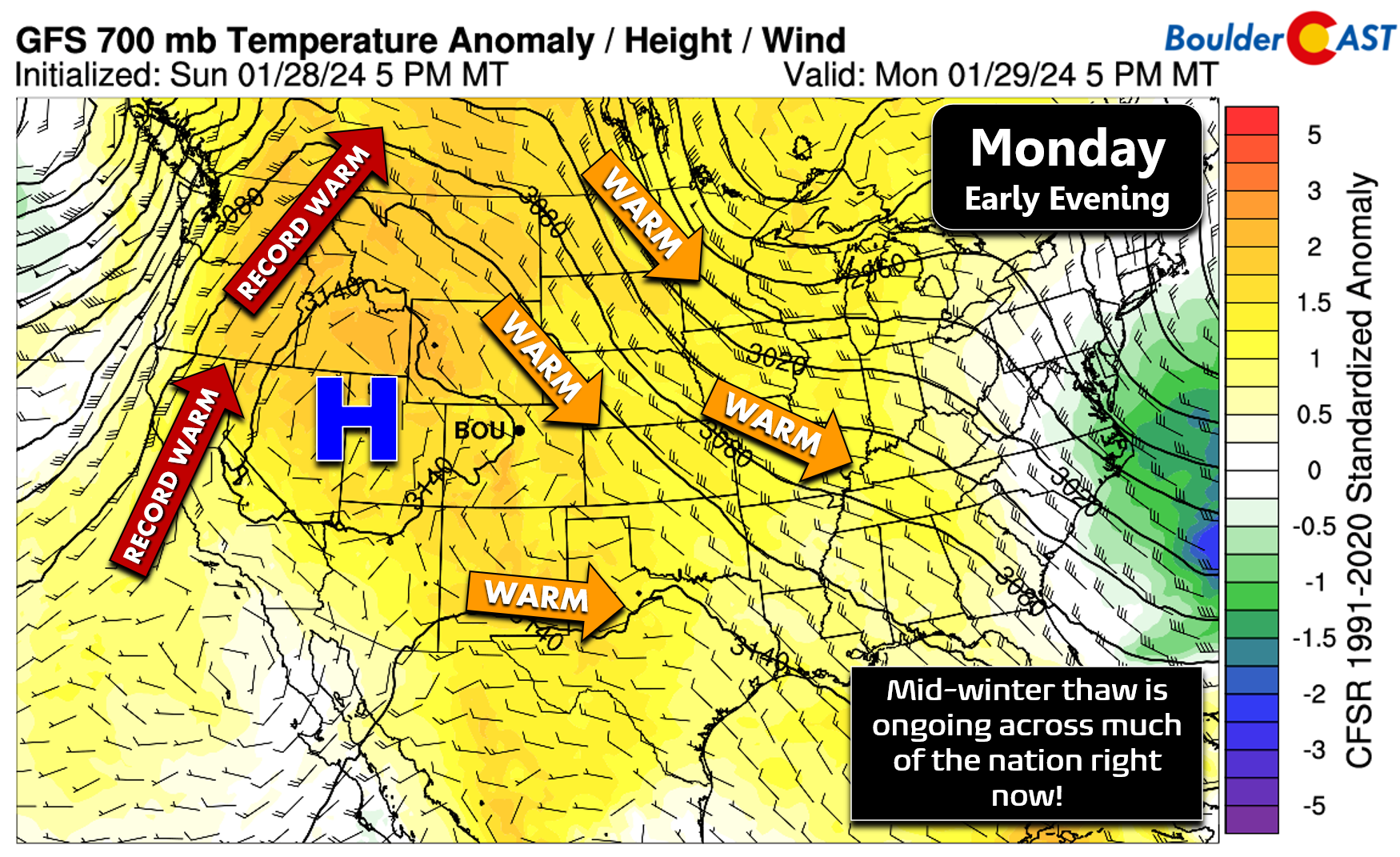
The mid-winter thaw has begun!
We finally hit sixty degrees on Sunday in Boulder and Denver for the first time in 38 days — our last push to such toasty temperatures happened in the days leading up to Christmas. This reading on Sunday was just a small taste of what’s to come during the upcoming week with many days of sixties ahead!
It's been 38 days, but we finally reaches 60 degrees again this afternoon in #Boulder. This is just the first of many 60+ days to come this week before a big ol' wet & snowy storm hits during the upcoming weekend. Happy Sunday! 🏔️ 🌞 #cowx pic.twitter.com/vzQlgIO6yF
— BoulderCAST Weather 🏔️❄️ (@BoulderCAST) January 28, 2024
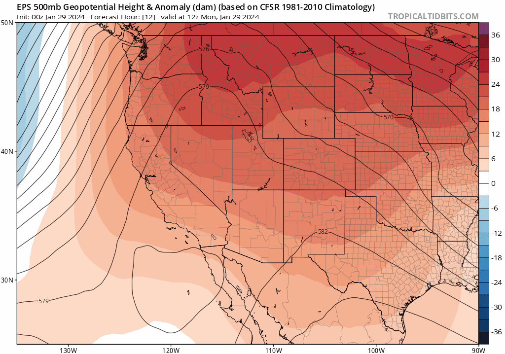
The weather pattern we are seeing unfold right now across North America — the one responsible for our recent and continued warmth — is a huge, amplified ridge of high pressure stretching from Baja California in Mexico all the way into the Canadian Arctic.
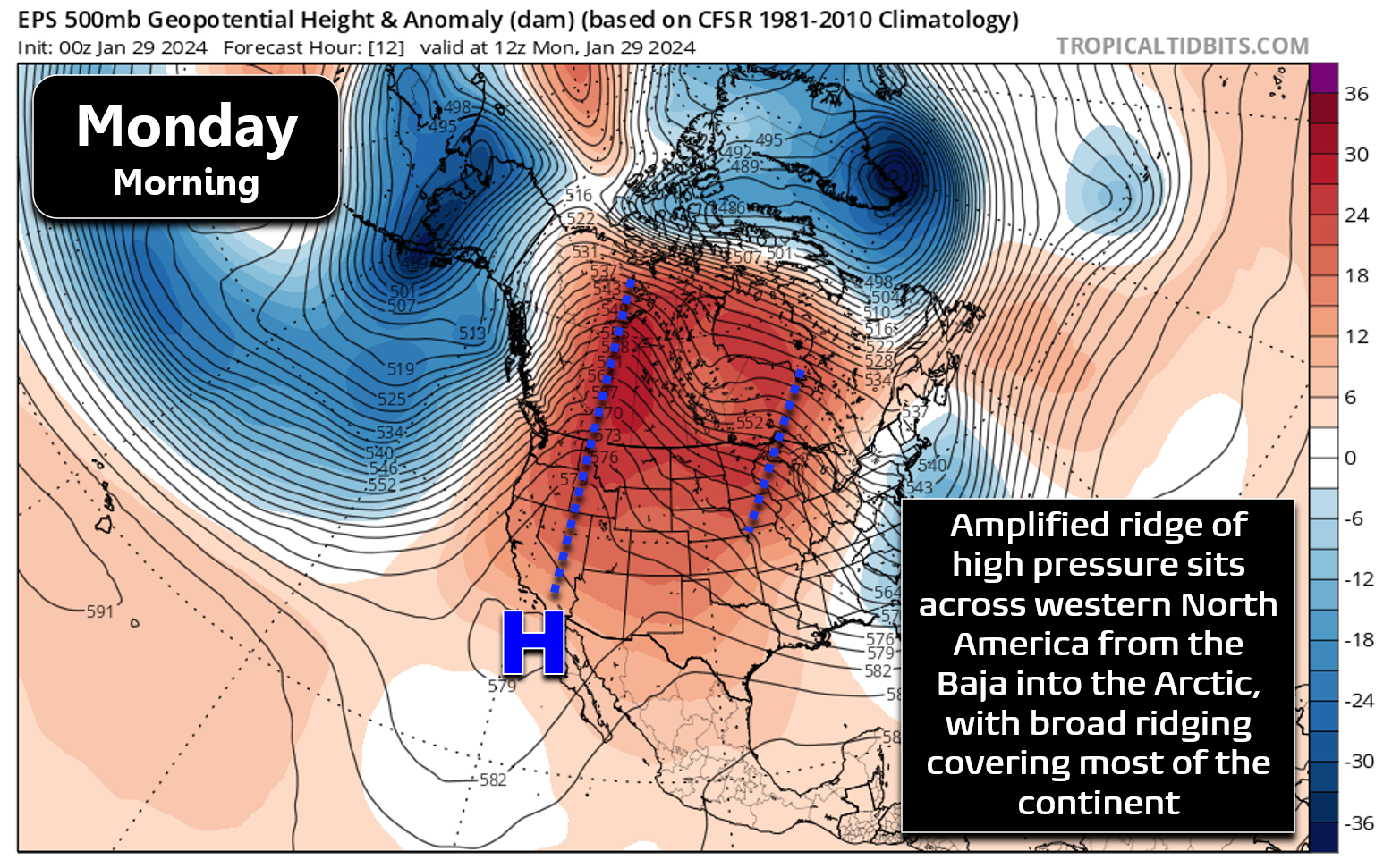
Underneath this ridge, a warm airmass has overspread much of the nation, including Colorado, leading to above normal temperatures across the board. The strongest warm anomalies with this pattern, as usual, will be to the west of the ridge axis in California, the Pacific Northwest, and parts of western Canada.
The graphic below shows some cities which will be closing in on their daily record high temperatures on Monday January 29th. Surprisingly, Grand Junction made the cut with a forecast high of 56°F which would tie the existing record set back in 1893. Here in the Denver Metro area, it will definitely be warm this week, but not quite record warm — the ridge isn’t in the prime location for us. This time of year, our record highs are all in the 70s — a bar we just aren’t going to clear this week, for better or worse.
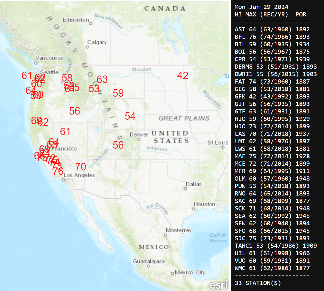
Forecast high temperatures that will be challenged across the West on Monday
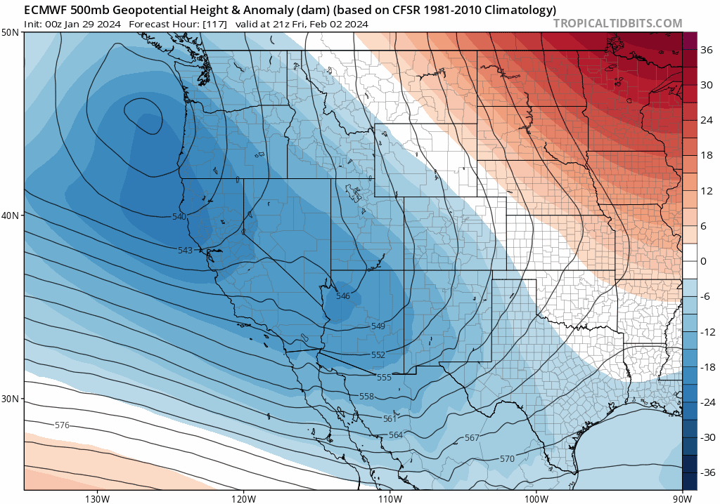
Nonetheless, this warm pattern will stick with us through most of the week ahead as the ridge slowly drifts eastward. Through at least Thursday, our high temperatures will soar into the low to middle 60s every single day in the Front Range. It’s not until very late in the week where we start to see the potent ridge shift off into eastern Canada and the Great Lakes, replaced by a rapidly developing trough pushing into the Four Corners from California.
This trough will bring a surge of clouds, cooler temperatures and even a chance of rain showers for our Friday. This incoming storm might have very significant impacts on our weekend weather — more on that in a moment! For now, plan on at least four more very pleasant and warm days in the Boulder-Denver area with plenty of sunshine to go around alongside temperatures in the low to middle 60s. This week will offer perfect weather for taking down any overdue holiday decorations (hint, hint!). By Friday, temperatures will fall back about ten degrees with a chance of late-day rain showers. The timing of the rain is fuzzy right now, but it should be afternoon or later, perhaps not entering the picture until sometime Friday night.
The potential for a significant rain/snow storm this weekend
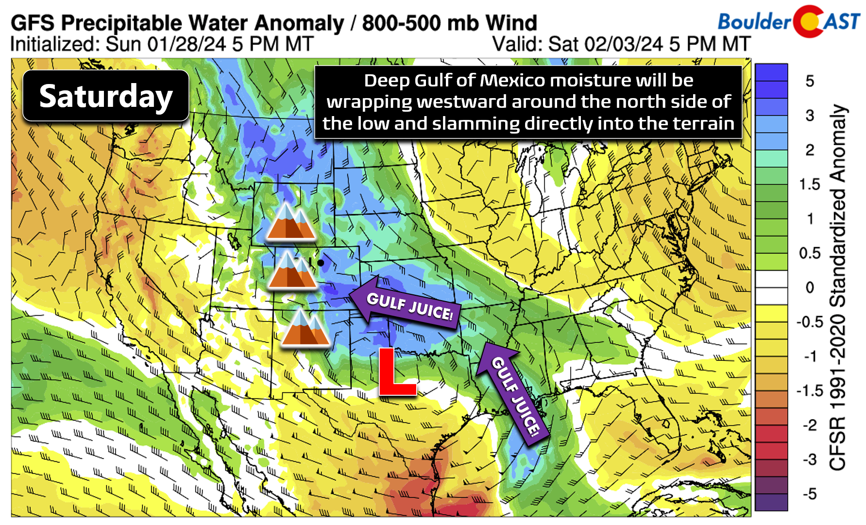
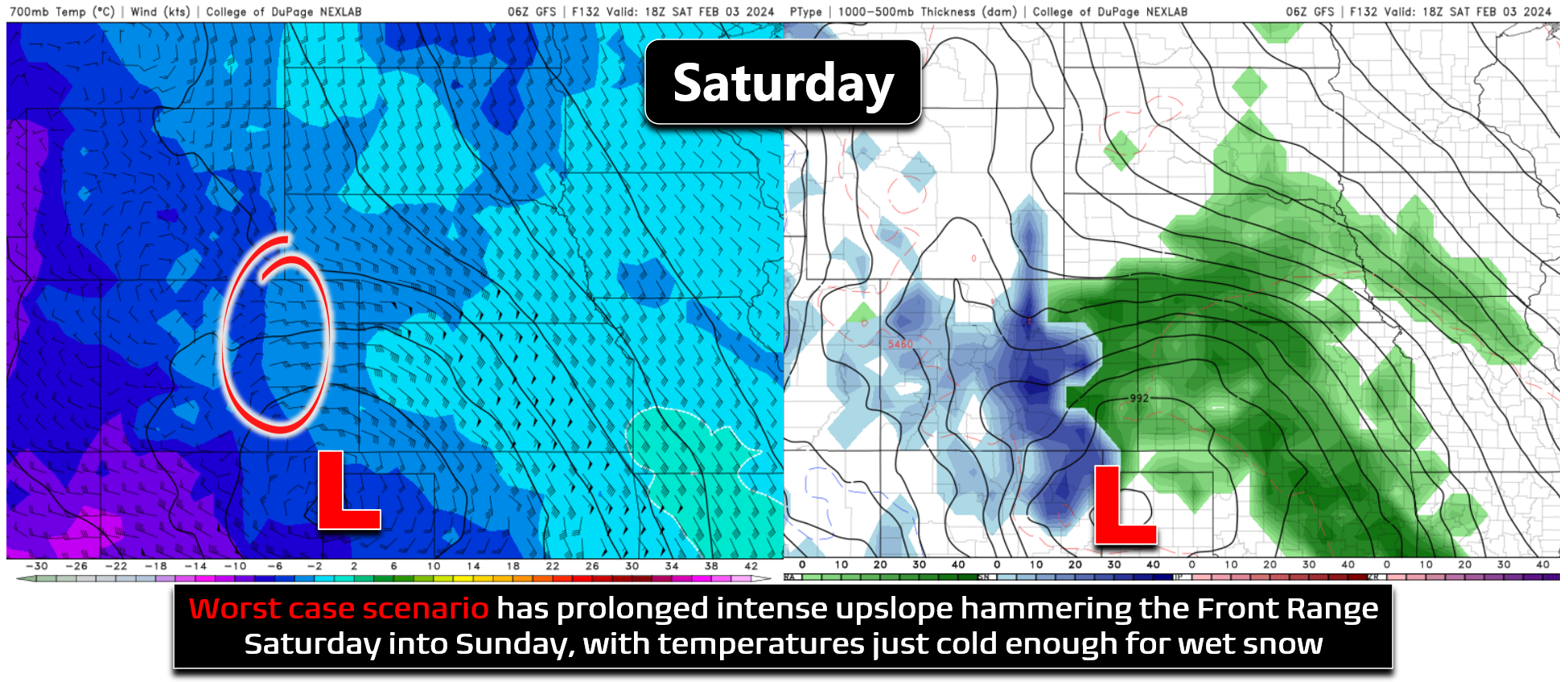
As we hinted at earlier, the late-week trough bears very close watching as it has all the makings to produce a major storm across the southern High Plains — anywhere from Cheyenne to Albuquerque (and eastward) could end up in the bullseye. Some model runs have been hinting that this storm will evolve in such a way to absolutely hammer the Front Range with widespread upslope rain and heavy wet snow this weekend. However, at this point in time, five to six days out, our overall confidence is low regarding the weekend setup. With that said, things do look concerning right now with an atypical negatively tilted trough axis spawning a very large and potent closed-low pressure across New Mexico Saturday into Sunday.
On the north side of this rapidly developing low pressure, a deep pipeline of Gulf of Mexico moisture will setup and flow westward, potentially slamming into Colorado’s terrain (see below). The exact location where this low pressure spawns will determine the slew of impacts here in the Front Range, and we’re just not sure where it will form yet. Large negatively tilted troughs often can spell disaster, usually in the form of damaging severe weather outbreaks (this storm will also check that box), but in some cases they can produce extreme snowfall on the eastern slopes of the Rockies. This is one setup that can often fire-up the fabled Upslope Snow Machine!
Forecast guidances continues to be all over the place with this weekend storm which is not surprising at all given the lead time. There is plenty of model-to-model variation, but also run-to-run fluctuations that make any definitive forecast impossible right now. For example, the worst case scenario would have a prolonged period of extremely moist and intense upslope hammering the Front Range Saturday into Sunday, with temperatures just cold enough for most of it to fall as heavy wet snow, accumulating upwards of two feet of sludge. However, this worst case scenario has less than 10% chance of occurring based on current model data. There is perhaps an equal chance of this storm ending up a complete miss for our area. The eventual reality, though, will probably be somewhere in the middle.
As an example of the extreme uncertainty, let’s compare the latest European and GFS precipitation forecasts for the weekend. The Euro model currently produces only a half inch or less of precipitation across the Metro area (below left) with the best dumping of moisture residing well to the east. However, the GFS dumps about five times that amount with 2-3″ of moisture across our entire area (below right)!
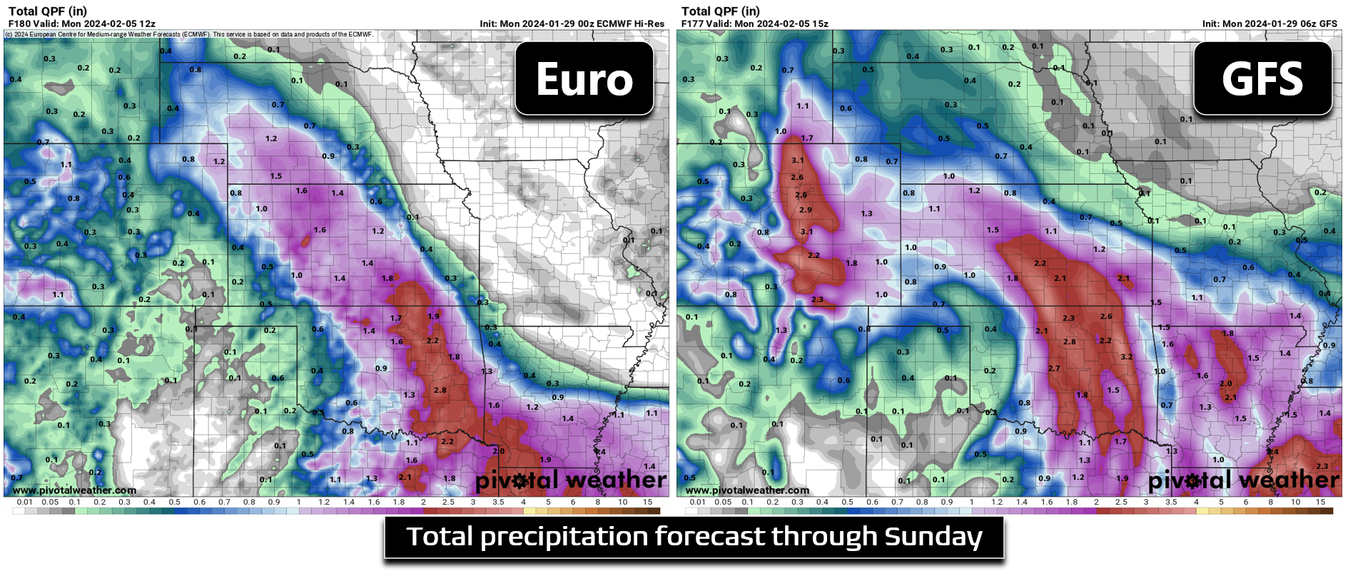
As you might imagine, this leads to a ridiculous discrepancy in potential snowfall totals, from just a couple inches with the Euro to more than two feet with the GFS:
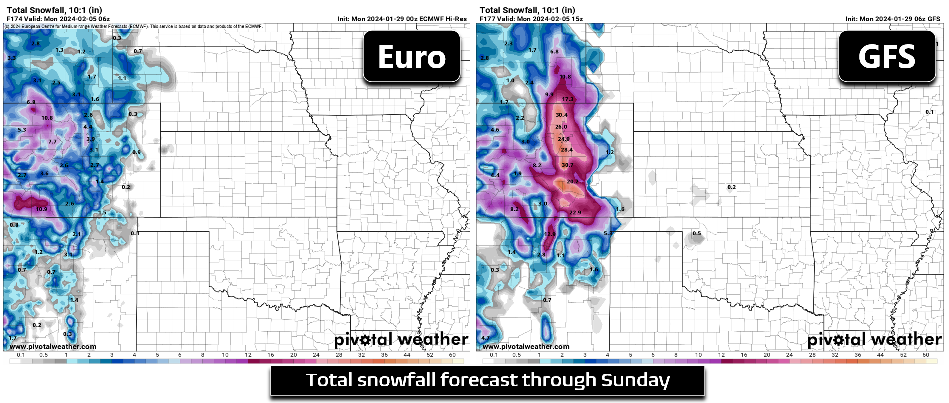
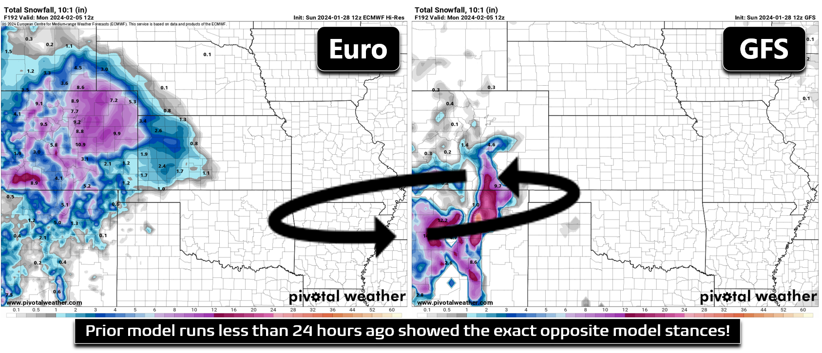
This discussed GFS-Euro relationship isn’t set in stone either, with this huge moisture discrepancy flip-flopping with each model run. Just yesterday it was the Euro model slamming all of northeast Colorado with 6-12″ of heavy snow, while at the same time the GFS had barely a flake! The Euro model is typically the one that drums up the most media hype for our winter storms, despite being just barely more accurate than the GFS. More than a few of you have already reached out to our team over the last few days asking about “the two feet of snow” inbound, an outcome that is currently being propped up by outlier model data seven days into the future…
In all seriousness, though, there is an excellent chance we do see some snowfall this weekend, with perhaps the most likely scenario landing as our biggest snowstorm of the season thus far. Let’s take a look at the ensembles, a very helpful tool when model variation is so high this far out. Snowfall forecasts derived from 20 different ensemble runs from the GFS model are shown below. Yes, there are a couple members that have more than two feet of snow, but the much more favored outcome is something much lower, perhaps in th 4-10″ range for the Metro area. There are also numerous runs that produce less than 4″ of snow here.
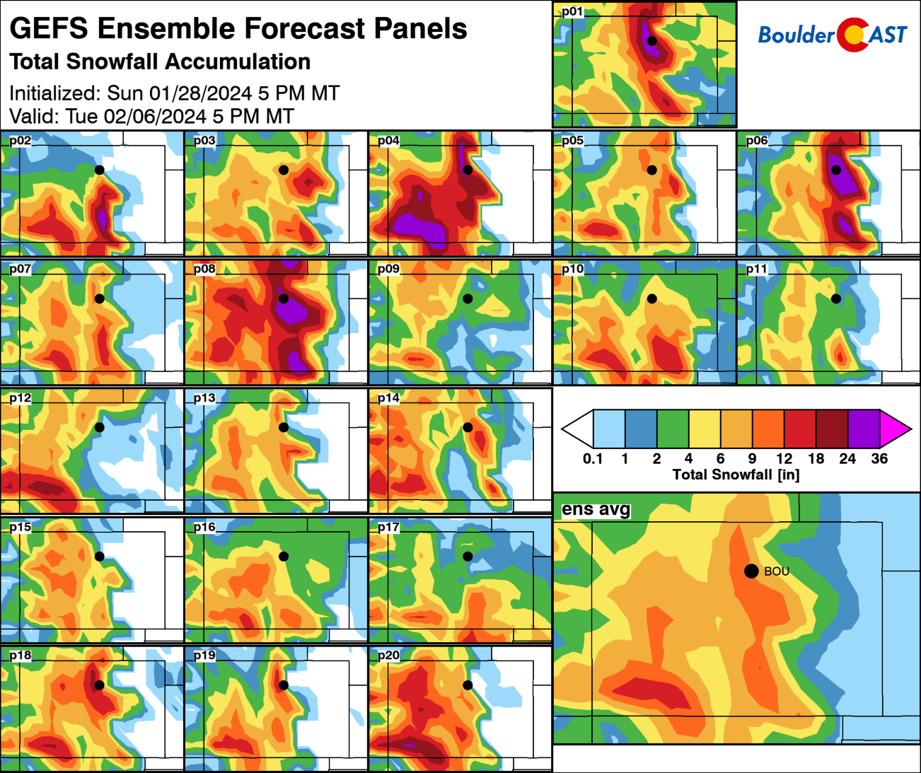
Something we also haven’t fully discussed yet, but is sure to complicate things this weekend, are the temperatures. With so much Gulf of Mexico moisture wrapping into the weekend storm, it will also pull in a lot of warm air. Thus, whatever precipitation ultimately does materialize will certainly begin as rain with a change-over to snow. The exact location of rain/snow remains uncertain. Obviously more rain would mean less snow, and vice versa. There isn’t really a definitive cold front with this system to ensure this will be a snowstorm, rather than a rainstorm, for the Front Range.
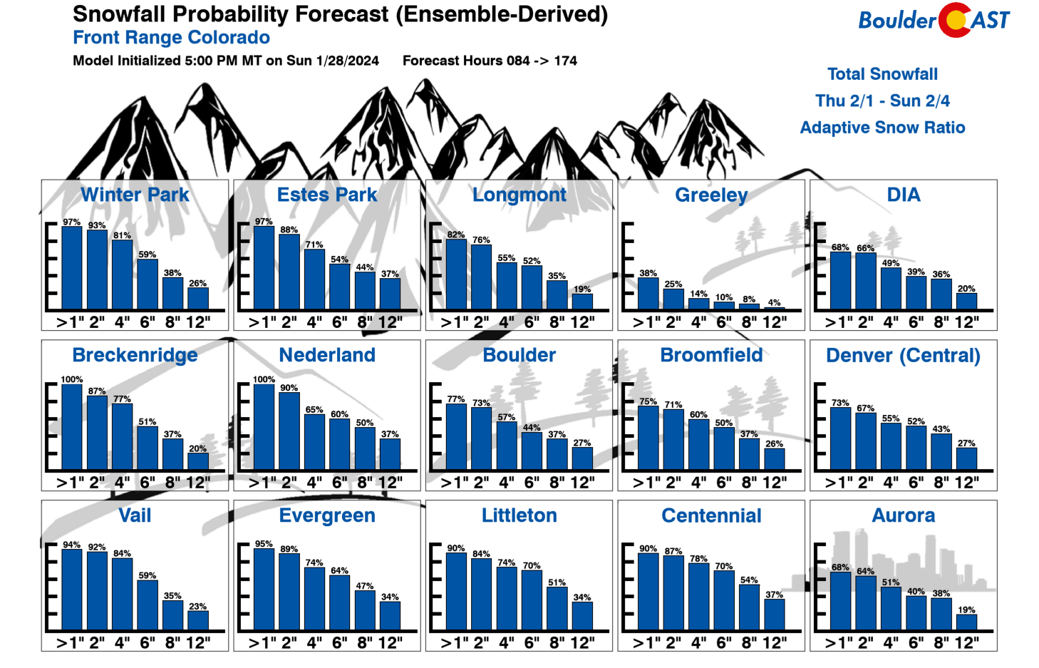
In summary, while models currently do agree quite well on the general atmospheric pattern — that is, a strong Pacific storm translating across the Four Corners into a negatively-tilted closed-low over New Mexico — the exact forecast for the weekend remains definitively uncertain. We fully expect to see continued truly wild model predictions and fluctuations in the coming days — something that may not fully resolve itself until Thursday or Friday when this storm system finally comes ashore into the Pacific Northwest. We will continue to closely monitor the evolution of the upper-level features as they approach, and the resulting impact they will have on the track of the storm, the flow of deep Gulf moisture westward, the upslope efficiency and duration over the Front Range, and the temperature profiles which will be right on the cusp of rain and snow for us. The “flatness” of our latest Snowfall Probability Charts is as clear of a sign as any that the models aren’t quite sure how to handle this system at this time. The Denver area currently has an approximately equal chance of seeing less than 1″ of snow as seeing more than 12″ (~25% chance of each, with a 50% chance of seeing 2-12″).
For now, enjoy the beautiful weather the next few days and check back for updates through the week on what is sure to be a messy weekend forecast! Be sure to follow us on Twitter, Facebook, and (finally now) on Threads for more timely updates as this likely impactful rain-to-snow event approaches!
Get BoulderCAST updates delivered to your inbox:
Forecast Specifics:
Monday: A few morning clouds, then totally sunny. Highs reach the lower 60s on the Plains with lower 50s in the Foothills.
Tuesday: Another stunning day with sunny skies and light winds. Temperatures soar into the middle 60s again on the Plains with lower 50s in the Foothills.
Wednesday: Staying very nice, but with some clouds around. Highs in the low to middle 60s on the Plains and in the lower 50s in the Foothills.
Thursday: More sunshine, but temperatures cool slightly ahead of an approaching trough with light SE-erly upslope flow. Highs will top out around 60 degrees on the Plains with lower 50s in the Foothills.
Friday: Mostly cloudy and cooler with a slight chance of late-day rain showers. High temperatures will be around 50 degrees on the Plains with upper 30s in the Foothills.
Weekend: All eyes are on an approaching storm system which is likely to bring a mix of rain to snow across the Front Range, with several inches of accumulation likely. Stay tuned as the forecast remains highly uncertain and is evolving day by day.
DISCLAIMER: This weekly outlook forecast is created Monday morning and covers the entire upcoming week. Accuracy will decrease as the week progresses as this post is NOT updated. To receive daily updated forecasts from our team, among many other perks, subscribe to BoulderCAST Premium.
Go Premium, get all the perks.
Daily Forecast Updates
Get our daily forecast discussion every morning delivered to your inbox.
All Our Model Data
Access to all our Colorado-centric high-resolution weather model graphics. Seriously — every one!
Ski & Hiking Forecasts
6-day forecasts for all the Colorado ski resorts, plus more than 120 hiking trails, including every 14er.
Smoke Forecasts
Wildfire smoke concentration predictions up to 72 hours into the future.
Exclusive Content
Weekend outlooks every Thursday, bonus storm updates, historical data and much more!
No Advertisements
Enjoy ad-free viewing on the entire site.
Enjoy our content? Give it a share!


You must be logged in to post a comment.