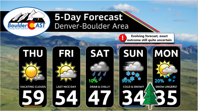
We’ve got a few more mild days ahead to end the work week, but as promised, winter will return for the holiday weekend in what is shaping up to be a challenging forecast indeed. We are finally starting to see better agreement in the various weather models, but things are still far from certain. Our weather will begin to trend downhill on Saturday with cooler temperatures and a chance of rain showers. Saturday night rain will change to snow with snow accumulation likely for all heading into Christmas Eve. Exact snowfall amounts and the timing of everything are still being worked out, but here’s our latest thoughts on the approaching holiday winter storm.
A
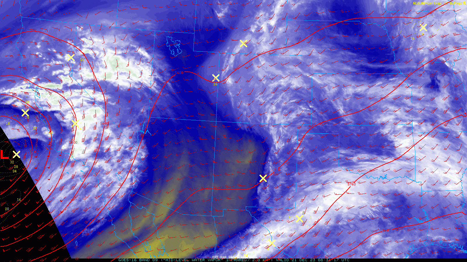
weak disturbance is clipping across the region Thursday morning producing mainly just clouds, but also a few light snow flurries in the Mountains of southern Colorado. The GOES-East water vapor animation below shows the shortwave nicely this morning — visible as just a slight “dip” in the height lines across Colorado/New Mexico and a few vorticity maxima (X’s). This system is producing widespread clouds across the Front Range early Thursday, but these will clear out rather quickly through the day with sunny skies taking over. The back edge of the clouds is already working across central Colorado as of writing — this drier and subsident air will reach the Denver area later this morning.
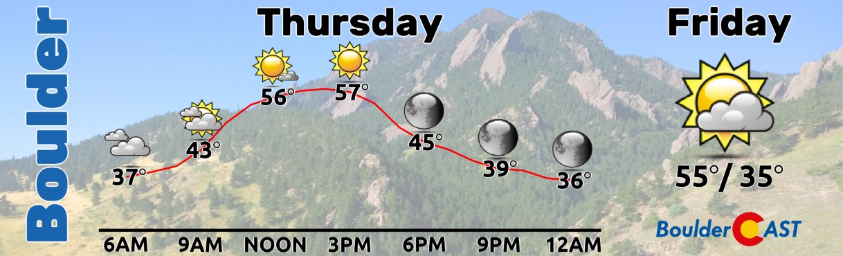
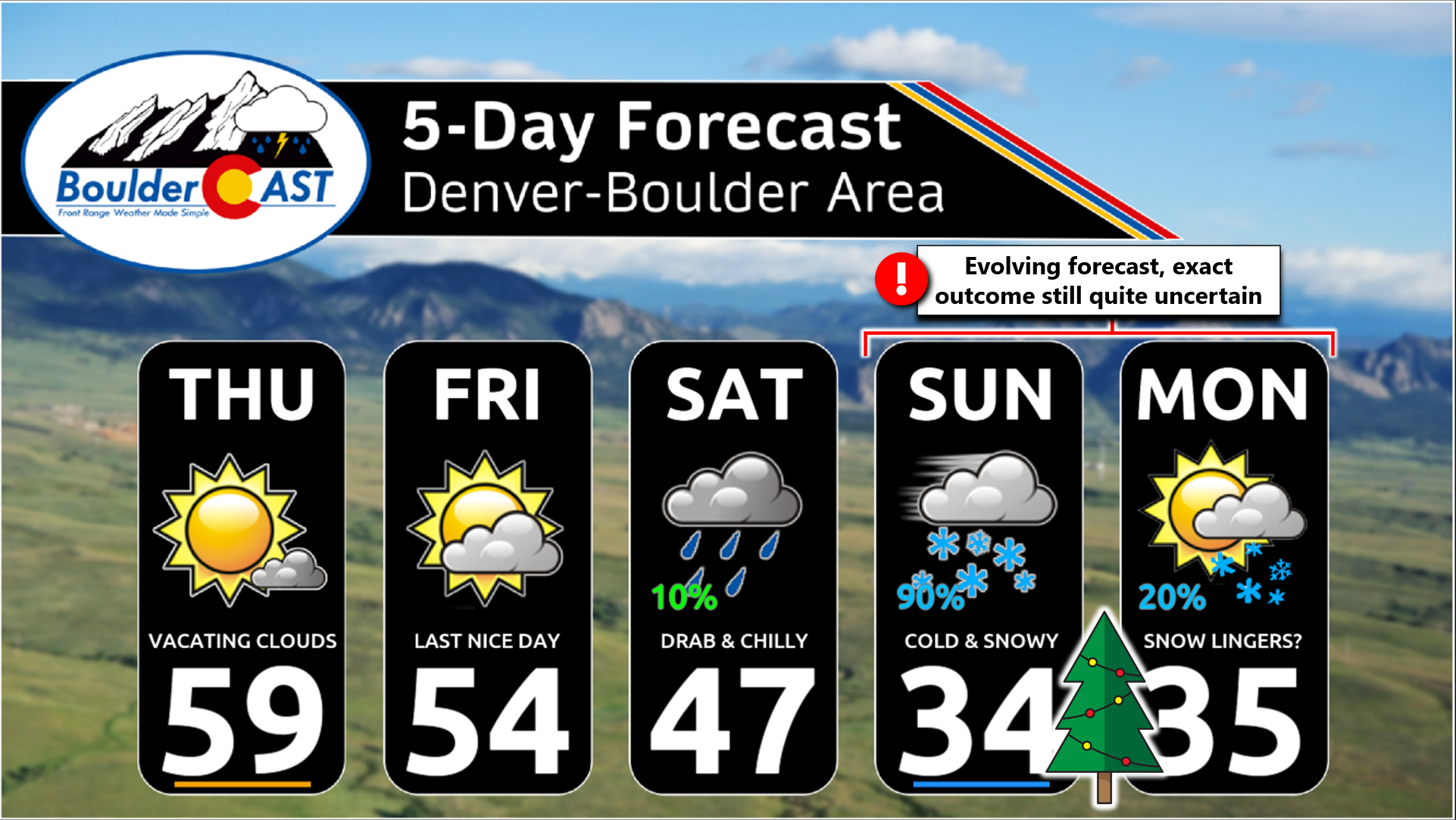
It will be another mild day out there with light winds and temperatures pushing towards the 60° mark. The main change for today is that it will be a whole lot sunnier (after the morning clouds vacate, that is). On Friday, things will essentially be the same — one last pretty nice and mild day before the weather turns this weekend. Friday’s highs will be in the middle to upper 50s under partly cloudy skies.
Rightfully so, almost all of our attention right now is geared towards the tricky situation about to unfold this weekend. We warned you days ago about this impending winter weather for the holiday period — and just how difficult this forecast was shaping up to be. The cause of such a grueling forecast is the fact that two different storm systems will be merging together over our area — a warmer southern-track low pressure coming in from the Baja will meet up with a colder, more typical wintertime trough dipping south out of western Canada. Exactly how these two systems phase together and interact will ultimately determine the range of impacts across the Front Range Saturday into Monday.
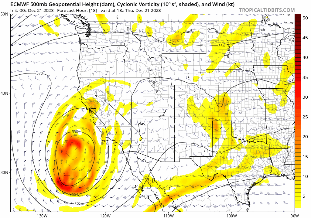
The latest GFS model forecast for 500mb is shown below. As we’ve seen all along, the GFS brings the systems through relatively quickly, and perhaps doesn’t even fully merge them together with the southern storm’s energy getting swept away towards the Great Lakes.
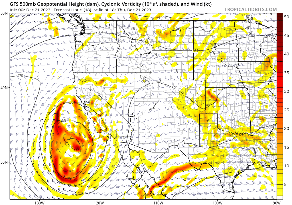
This evolution from the GFS results in a quicker period of rain changing to snow for the Front Range, mainly Saturday night into Sunday, and perhaps just 1-4″ of snow for us with most of the accumulation over and done with by midday on Sunday. With the storm exiting quicker, Christmas Day ends up fairly mild (40s) and sunny.
The Euro model, while somewhat similar, also has some stark differences in its projection of how this weekend will unfold. The Euro fully merges the two storms together and produces a big cut-off low right over Colorado — in a position that still isn’t all that favorable for the Denver Metro area. We still see some signs of the Fujiwhara effect we discussed yesterday as well. This setup would lead to a longer duration of precipitation across our area, with rain changing to snow Saturday night and then light snow lingering well into Sunday or perhaps even parts of Monday. This results in about 2-5″ of snow across the Metro area — yes a longer duration but the fairly light snowfall rates produce a similar accumulation result to the GFS.
As you can see, there is still less-than-ideal agreement between the various models, though some aspects of the holiday weekend forecast have become more clear. Here’s some of our current expectations:
- A cold front will drop southward across eastern Colorado on Saturday — making for a colder day overall with highs only in the 40s to lower 50s. Skies will be mostly cloudy with a slight chance of a few rain showers or sprinkles during the day, mainly late in the day. Most of us would be dry, though.
- Saturday night the energy from the southern storm arrives along with better moisture and a secondary, colder airmass. Precipitation will become more widespread with rain changing to snow overnight. This period of Saturday night into early Sunday is advertised to put down the most precipitation for the entire event, so temperatures and change-over timing will be critical on snow amounts. Rain likely changes to snow before midnight, but that’s not that certain right now.
- Most models, except the GFS, keep clouds and light snow showers or flurries locked in through the day Sunday. With temperatures near or slightly above freezing, this won’t have any major travel impacts. Maybe another coating-2″ of snow occur during the day, but probably not much more.
- Snow likely will taper off late Sunday or Sunday night, but a few models do keep at least the chance of snow lingering as wrap-around moisture flows back into the Front Range. Minimal additional accumulation is expected at the tail-end of the event.
- Monday’s forecast is perhaps the most uncertain, being five days away. There could be some morning clouds or light snow lingering, but there is some chance things are long gone by Monday and it’s simply a dry, sunny and mild day.
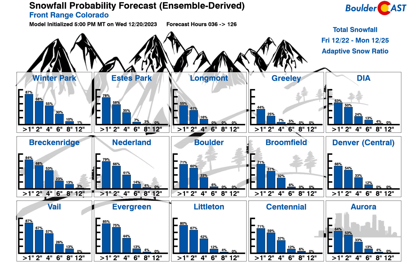
As for the most important aspect of the forecast, snowfall amounts, we’re still not comfortable nailing down an exact range given how much uncertainty still lingers. Thus, we will leave you with a probabilistic forecast for now as well as our latest Snowfall Probability Charts. Currently 2-5″ is the favored snow forecast for the Front Range — our thoughts on this haven’t changed much over the last several days.
- Less than 2″: 25%
- 2-5″: 60%
- 5-9″: 15%
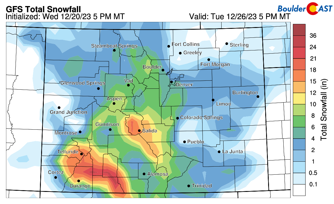
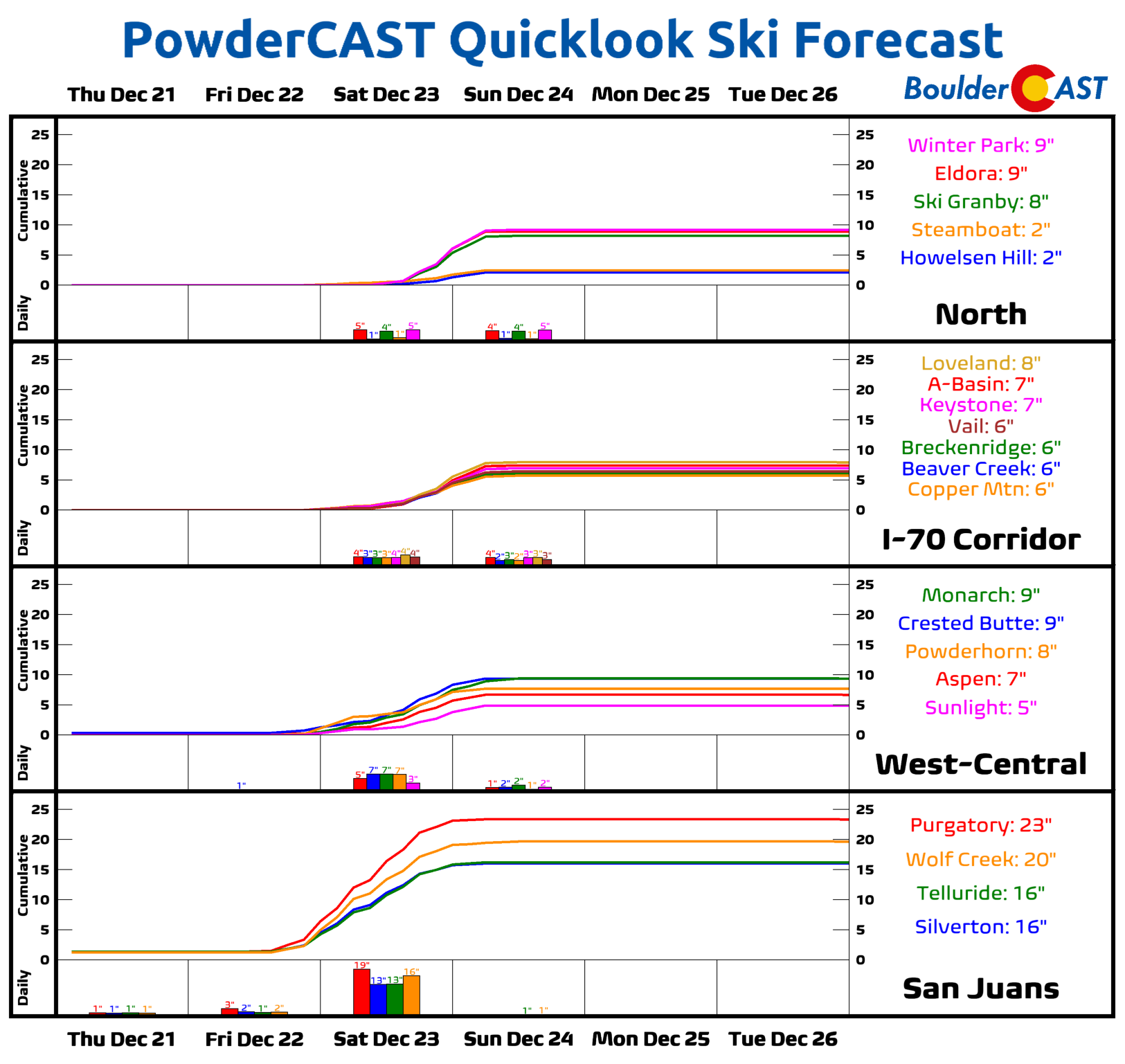
Mountain snow forecasts aren’t that impressive either, with the exception being the San Juans which are slated to receive 1 to 2 feet of powder this weekend, with southwestern Colorado benefiting from a prolonged period of moist southwest flow Saturday into early Sunday.
Ultimately, the winter weather forecast this holiday weekend still remains shrouded in a bit of uncertainty, but at least the most likely outcome is a relatively minor snowfall event for us with limited travel impacts. Previously there was a small chance that this weekend could offer up “the big one” with a foot of snow, but that chance has dwindled down to nearly zero at this point. We’re not seeing much that could cause any major issues out at DIA, and highway travel looks to be mostly okay as well throughout the weekend. One area to watch could be heading south out of Denver over the Palmer Divide towards the Springs. Colder temperatures and potentially slightly higher snowfall amounts there could cause some issues.
We’ll continue to monitor the situation in the coming days and pass along any updates as needed, including our final snowfall forecast map late Friday or Saturday morning. Stay tuned and subscribed!
Get BoulderCAST updates delivered to your inbox:

Go Premium, get all the perks.
Daily Forecast Updates
Get our daily forecast discussion every morning delivered to your inbox.
All Our Model Data
Access to all our Colorado-centric high-resolution weather model graphics. Seriously — every one!
Ski & Hiking Forecasts
6-day forecasts for all the Colorado ski resorts, plus more than 120 hiking trails, including every 14er.
Smoke Forecasts
Wildfire smoke concentration predictions up to 72 hours into the future.
Exclusive Content
Weekend outlooks every Thursday, bonus storm updates, historical data and much more!
No Advertisements
Enjoy ad-free viewing on the entire site.
Enjoy our content? Help us out and give it a share:


You must be logged in to post a comment.