The work week ahead will feature veritably pleasant weather across the Front Range with warm temperatures and dry conditions persisting through Friday, including at least one day of potential record highs. However, things will take a drastic wintry turn for the upcoming weekend with accumulating snow highly likely in the days leading up the Christmas. Despite heaps of uncertainty, we also discuss the latest details for the evolving winter storm set to cause travel impacts across the broader High Plains region during the busy holiday weekend ahead.
This week’s highlights include:
- Ridging aloft will dominate our weather this week with very warm temperatures and dry conditions expected through Friday
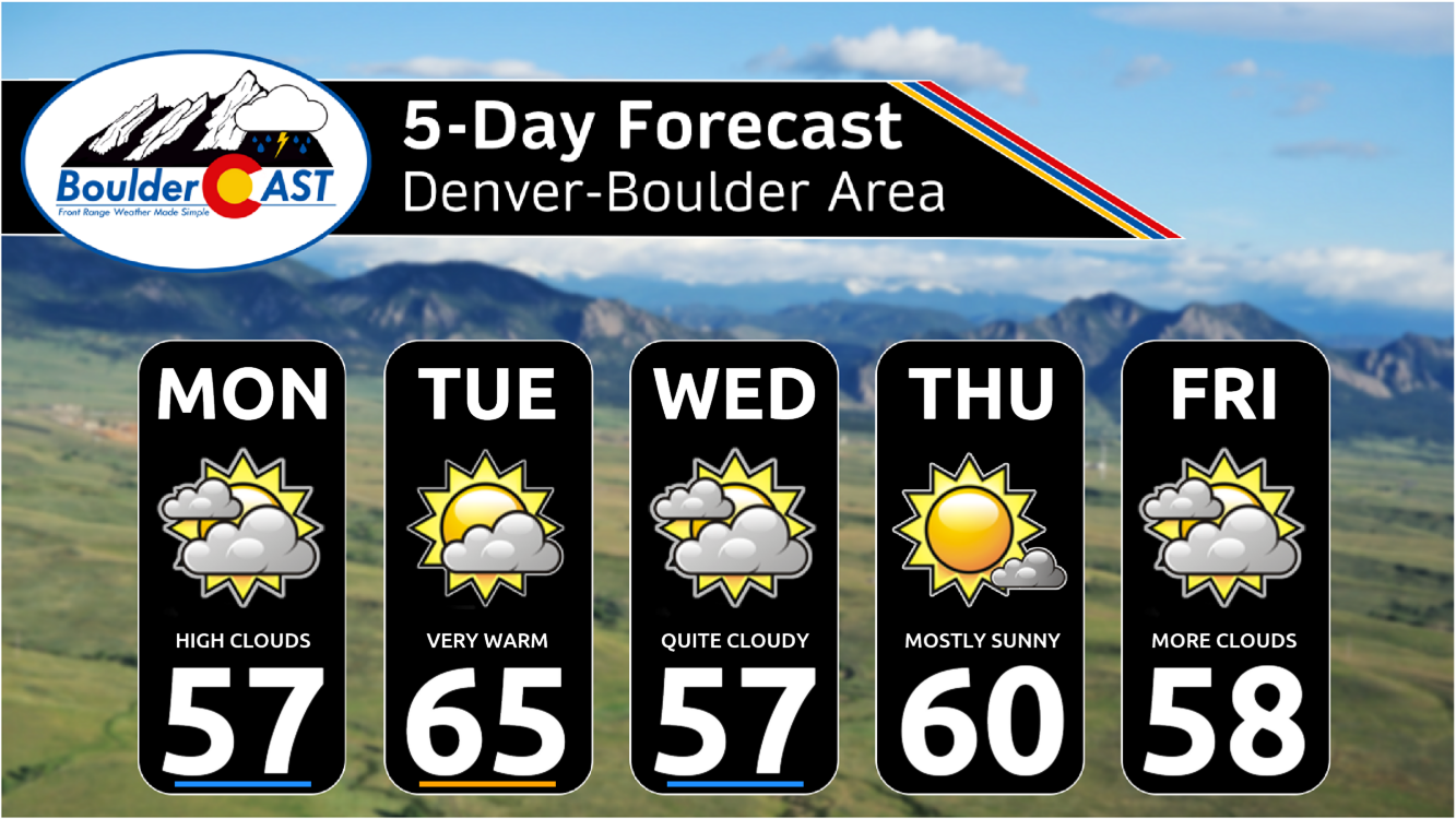
- Highs will generally range from the middle 50s to middle 60s this week, the warmest day being Tuesday when record highs will be up for grabs
- A complex forecast is taking shape for the holiday weekend ahead with two storm systems merging right over Colorado
- While the exact forecast remains uncertain, accumulating snow appears very likely for our area sometime late Saturday through Monday (Christmas Day)
- Snowfall amounts of 3-6″ are favored right now, but this could certainly shift (up or down)
- Temperatures will also fall below normal with highs in the 30s favored heading into the holiday
DISCLAIMER: This weekly outlook forecast is created Monday morning and covers the entire upcoming week. Accuracy will decrease as the week progresses as this post is NOT updated. To receive daily updated forecasts from our team, among many other perks, subscribe to BoulderCAST Premium.

Go Premium, get all the perks.
Daily Forecast Updates
Get our daily forecast discussion every morning delivered to your inbox.
All Our Model Data
Access to all our Colorado-centric high-resolution weather model graphics. Seriously — every one!
Ski & Hiking Forecasts
6-day forecasts for all the Colorado ski resorts, plus more than 120 hiking trails, including every 14er.
Smoke Forecasts
Wildfire smoke concentration predictions up to 72 hours into the future.
Exclusive Content
Weekend outlooks every Thursday, bonus storm updates, historical data and much more!
No Advertisements
Enjoy ad-free viewing on the entire site.
A warm & dry week precedes a likely snowy holiday weekend
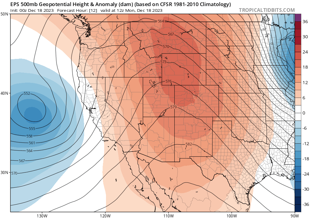
For most of the week ahead, Colorado will be under the influence of broad ridging aloft with largely dry and warm conditions expected across the Front Range. The European ensemble 500mb height forecast animation below runs from Monday through Friday. Notice the ridging (orange shading) present over our area throughout the entire week. This setup with keep things unseasonably warm and dry for the next five days or so. However, towards the end of the animation, two systems are shown to be along the West Coast upstream from Colorado — one in the Pacific Northwest and another near the Baja. We’ll be watching these developing disturbances closely to bring cooler temperatures and some snow this weekend for us. More on that in a moment…
Both this past Saturday and Sunday saw high temperatures reach into the 60s across the Denver Metro area’s lower elevations, but light winds and increased upper-level cloud cover on Monday will cool us off just a tad into the mid to upper 50s. NowCAST is showing a high of 58°F in Denver Monday afternoon with light and variable winds.

On Tuesday, the primary ridge axis will shift east of the Front Range, with an uptick in drier southwest flow expected for the area.
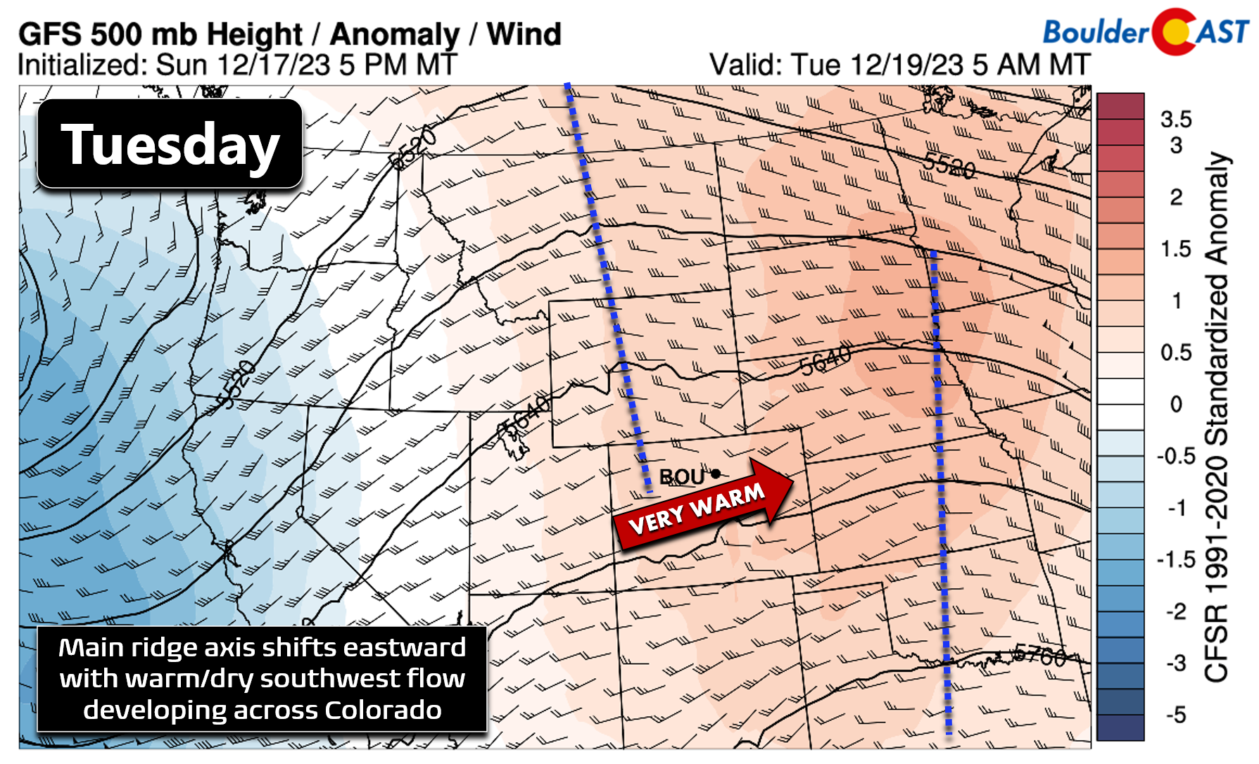
This will lead to continued warming temperatures aloft, but also more sunshine and an uptick in surface winds. All of these factors will contribute to Tuesday being the warmest day of the week for us — one which will allow most cities to experience near-record warmth. The existing record highs for December 19th are 69°F and 67°F for Boulder (below) and Denver, respectively. We’ll be close to these values, but Boulder in particular likely will come up short. Either way, Tuesday will be the nicest day of the week — though admittedly every other day will be quite pleasant as well.

Beyond Tuesday, the rest of the week will see temperatures drop slightly as several tiny shortwave features traverse the area leading to cooling aloft and waves of increased mid and high-level cloud cover. After 700mb temperatures reach near +5°C on Tuesday, they will be closer +1°C the rest of the week.

This will translate into high temperatures cooler in the upper 50s to lower 60s each day — not bad of course for late December! There will be more clouds around this week than we are used to here in the Front Range (300 days of sunshine, yada yada…), but Tuesday and Thursday will see more sun comparatively.
On top of the warm temperatures, there’s basically no chance of any precipitation for us through Friday — a completely dry week.
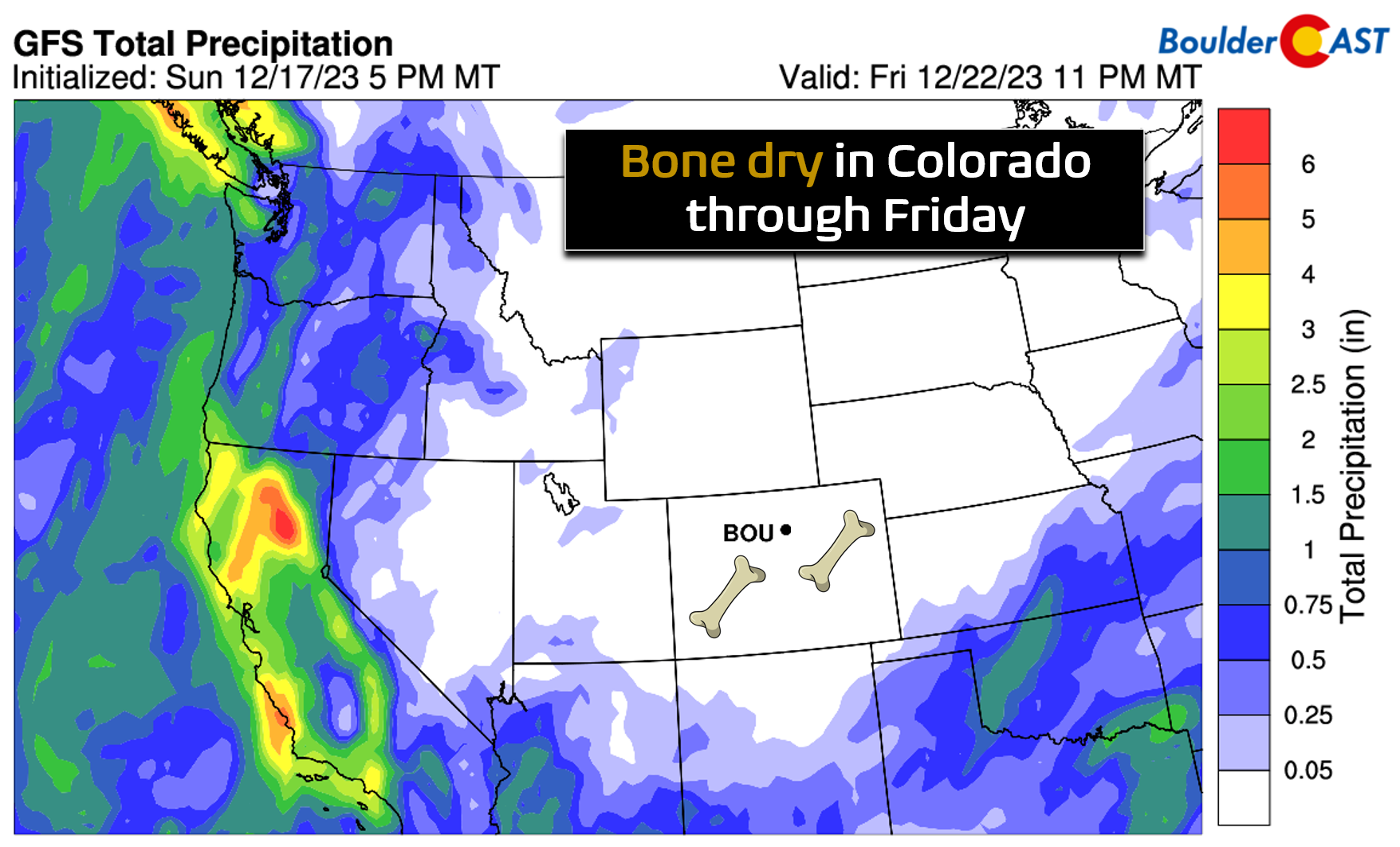
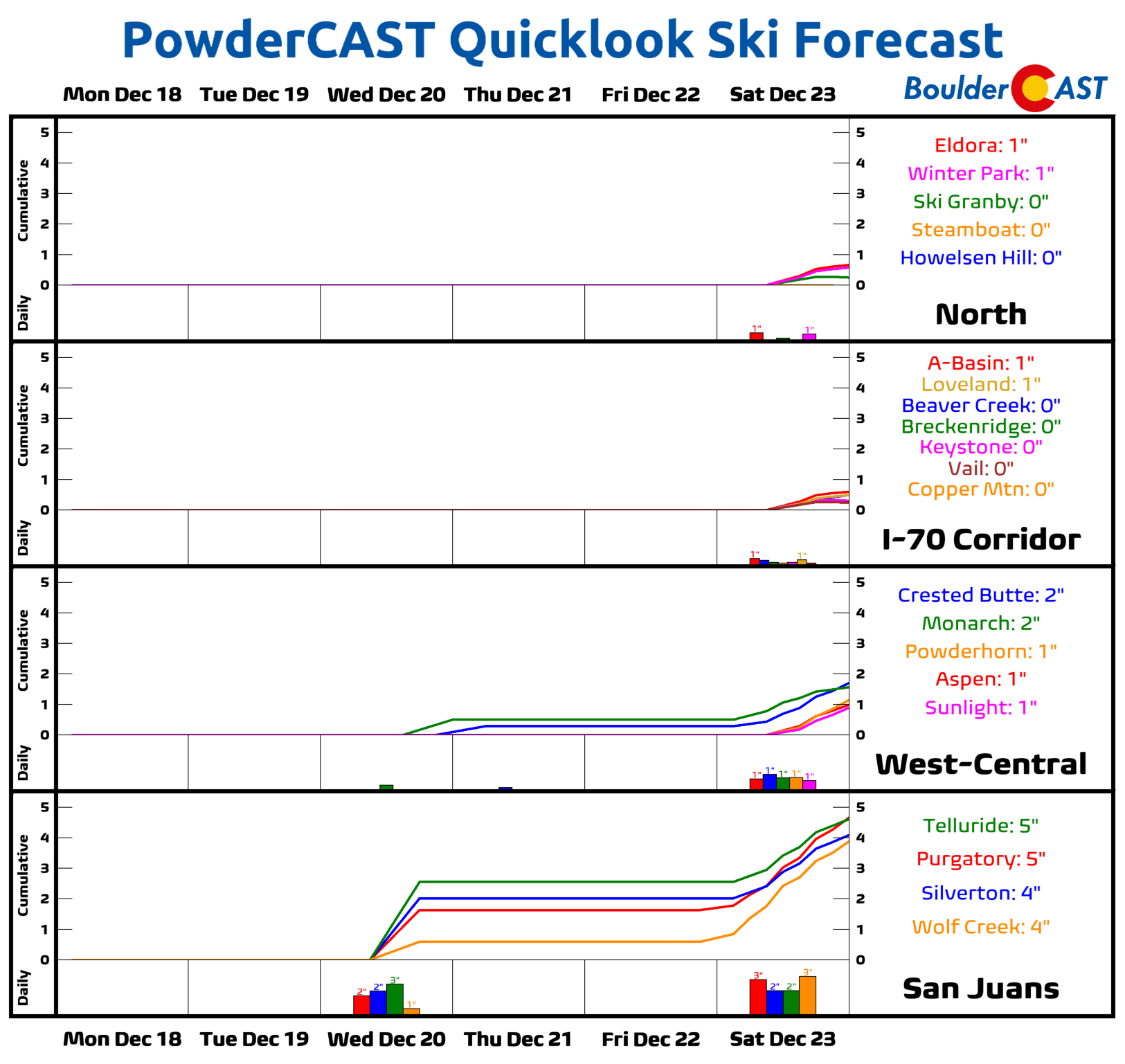
The same is mostly true for the Mountains as well, though we wouldn’t be surprised to see a few isolated snow showers at times this week, especially in the southern tier of the state. This week’s powder outlook is bleak, though. Sorry, skiers!
Snow highly likely leading up to Christmas
Earlier we hinted at the prospect of snow for the upcoming weekend leading up to Christmas — that is definitely something we are watching closely right now. It’s still way too early to gauge the exact forecast, but the broader atmospheric pattern is starting to come into focus. Ensemble guidance agrees that a southern stream low pressure near the Baja will merge with a bitter cold storm digging south out of the Pacific Northwest this weekend. This should eventually lead to a slow-moving, cut-off low over Colorado around Christmas Eve or Christmas. While this setup will certainly usher in much colder temperatures to the Front Range, the holiday snowfall outlook is less clear-cut as the way these two storm systems phase together and the resulting low’s track will be critical in determining where the heavier snowfall will setup.

Just to give you an idea of the uncertainty in things right now, take a look at the latest GFS ensemble-derived snowfall forecast panels below for Colorado. Anywhere from a dusting to a foot of snow is possible in the Front Range for the holiday! None of the panels really “bullseye” the Denver Metro area, which is perhaps a good sign for those hoping to travel into or out of town this weekend. None of the panels scream “major upslope snow” either. The more likely scenario right now has the heavier snow (and strong winds/blizzard conditions) being concentrated near a potential developing surface low out across the High Plains or Wyoming, eastern Colorado, Kansas, or Nebraska.
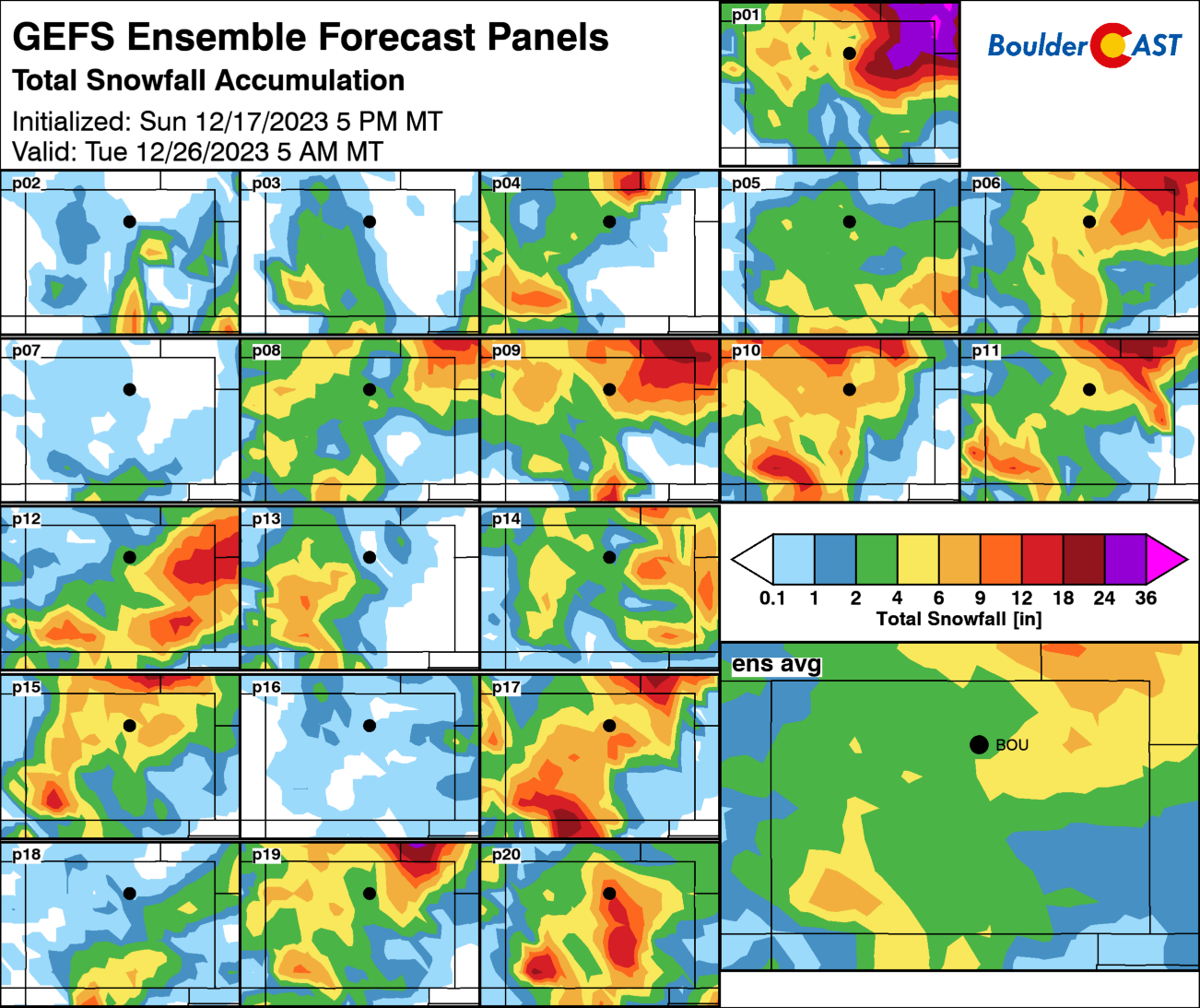
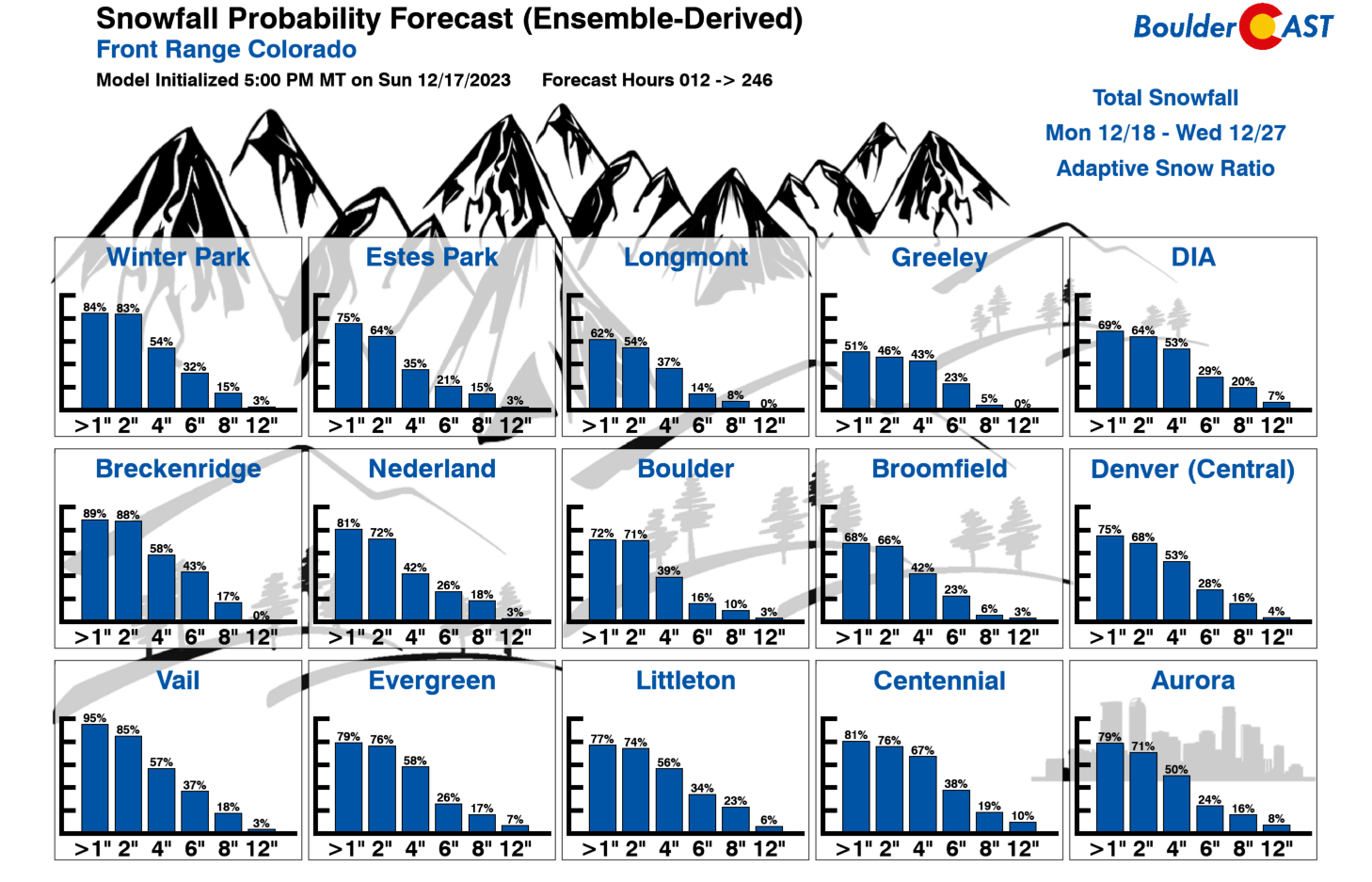
The ensemble mean forecast from the GFS (below left) and Euro (below right) are nearly identical for the Metro area right now — just shy of a half inch of moisture. However, as we mentioned, the mean doesn’t tell the full story as the overall spread is considerable. That’s no surprise as this is potential snow event is still 6 to 8 days away! It’s clear right now that this will be a big, slow-moving storm system — so it won’t just be a quick one and done type of snow for us. This will be a long-duration event with unsettled weather (i.e. snow, maybe some mix with rain in the early part of the event) possible anytime from late Saturday through late Monday (Christmas Day). It certainly won’t be snowing that entire time — things would come in waves — but that is the current timeline we are looking at. A “middle of the road” snowfall forecast, based on current model data, would be 2-5″ for our area. That will suffice for now, but expect that forecast to change as things draw nearer.

For now, this system definitely bears watching as even the low-end snow amounts will put a (minor) wrench into the second busiest holiday travel weekend of the year in Denver — those upper-end amounts would cripple travel into and out of DIA. Check back for updates from us this week as it certainly does appear Santa will have at least some amount of fresh snow to land his sleigh upon…
Get BoulderCAST updates delivered to your inbox:
Forecast Specifics:
Monday: Lots of high clouds around through the day leading to partly to mostly cloudy skies. Highs remain warm in the mid to upper 50s on the Plains with middle 40s in the Foothills.
Tuesday: More sunshine, but still some clouds around. The warmest day of the week with temperatures soaring towards record highs across the area. Highs reach the middle to upper 60s on the Plains with lower 50s in the Foothills.
Wednesday: Cloud cover returns with temperatures slightly cooler. Look for highs to reach the upper 50s on the Plains with middle 40s in the Foothills.
Thursday: Mostly sunny and rather warm. Highs top out near 60 degrees on the Plains with upper 40s in the Foothills.
Friday: Mostly cloudy and staying warm. Temperatures top out in the middle to upper 50s on the Plains with middle 40s in the Foothills.
Weekend: Keep an eye on the evolving forecast as accumulating snowfall is very likely in the days leading up to Christmas with travel impacts expected. Current expectations are for 3-6″ of snow in our area, but overall uncertainty is high (could be more or less). High temperatures plummet back into the 20s or 30s for Sunday and Monday.
DISCLAIMER: This weekly outlook forecast is created Monday morning and covers the entire upcoming week. Accuracy will decrease as the week progresses as this post is NOT updated. To receive daily updated forecasts from our team, among many other perks, subscribe to BoulderCAST Premium.
Go Premium, get all the perks.
Daily Forecast Updates
Get our daily forecast discussion every morning delivered to your inbox.
All Our Model Data
Access to all our Colorado-centric high-resolution weather model graphics. Seriously — every one!
Ski & Hiking Forecasts
6-day forecasts for all the Colorado ski resorts, plus more than 120 hiking trails, including every 14er.
Smoke Forecasts
Wildfire smoke concentration predictions up to 72 hours into the future.
Exclusive Content
Weekend outlooks every Thursday, bonus storm updates, historical data and much more!
No Advertisements
Enjoy ad-free viewing on the entire site.
Enjoy our content? Give it a share!


You must be logged in to post a comment.