Well, there’s no possible way of sugar-coating things here — our snowfall forecast for this one ended up being WAY off. Though hopefully our in-depth discussions beforehand stressed that the exact outcome of this specific snow event was much more uncertain than usual. Heck we even called out this forecast as being “a bit like playing a drunken game of darts”. We’ll first take a look at the regional snowfall totals, discuss what went wrong with the forecast and dive into what made this incredible moisture-infused spring-like storm so difficult to predict in the middle of winter.
We discuss Boulder and Denver weather every single day on BoulderCAST Premium. Sign up today to get access to our daily forecast discussions every morning, complete six-day skiing and hiking forecasts powered by machine learning, access to all our Front Range specific weather models, additional storm updates and much more!

L
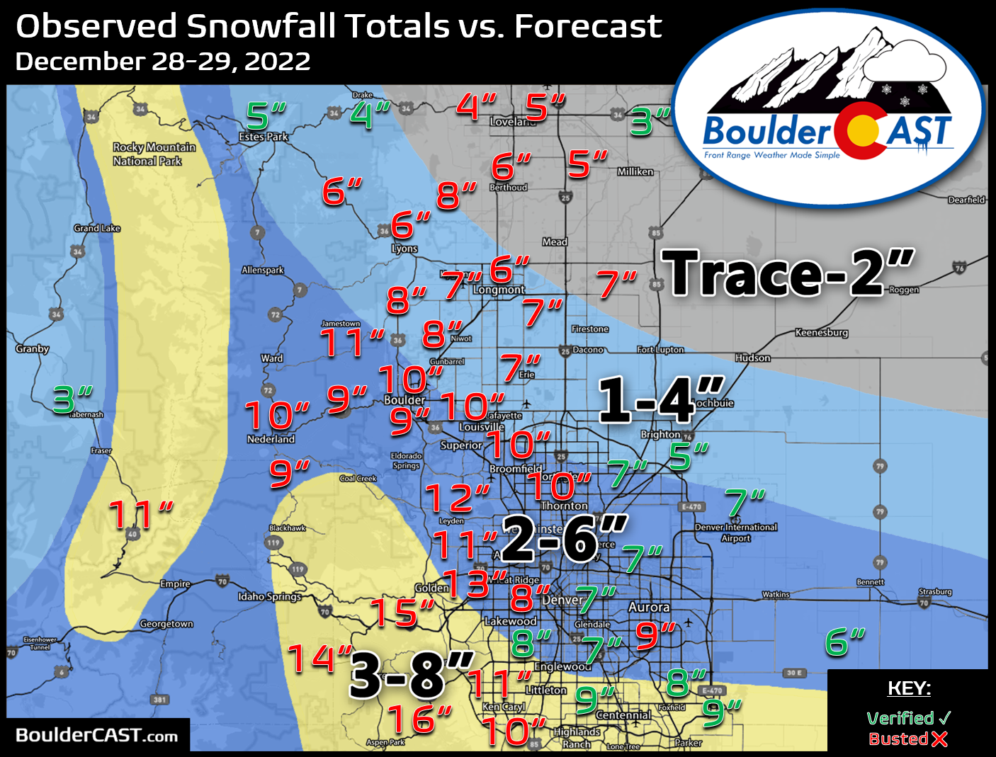
et’s dive right into the booming snow totals first. Anywhere from 3 to 16″ of soupy snow fell from Loveland, though the Denver area, and south to Colorado Springs. The heaviest dumping occurred in and near the Foothills of Jefferson County, the area we expected to see the most snow all along (but of course, not quite that much). Our snowfall forecast map for the event is shown below with storm totals overlaid. Green values indicate our forecast verified to within 1″. Red did not. Yeah — that’s terrible forecast verification overall, though parts of eastern Denver are not waking up that surprised this morning!
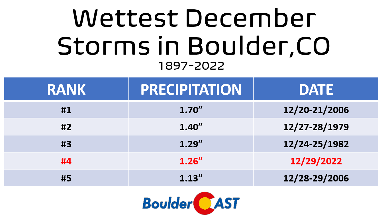
Officially Boulder reported 9.3″ of snow from this event alongside a whopping 1.26″ of precipitation (that includes rain and melted snow equivalent). The snow is not all that impressive — it doesn’t even rank in the top 25 for largest December snow events for the city. However, the amount of moisture that dumped on the area was extraordinary — this was the 4th largest December precipitation event for the city since the late 1800s. It’s clear that the “cement” we received last night is not a regular occurrence this time of year.
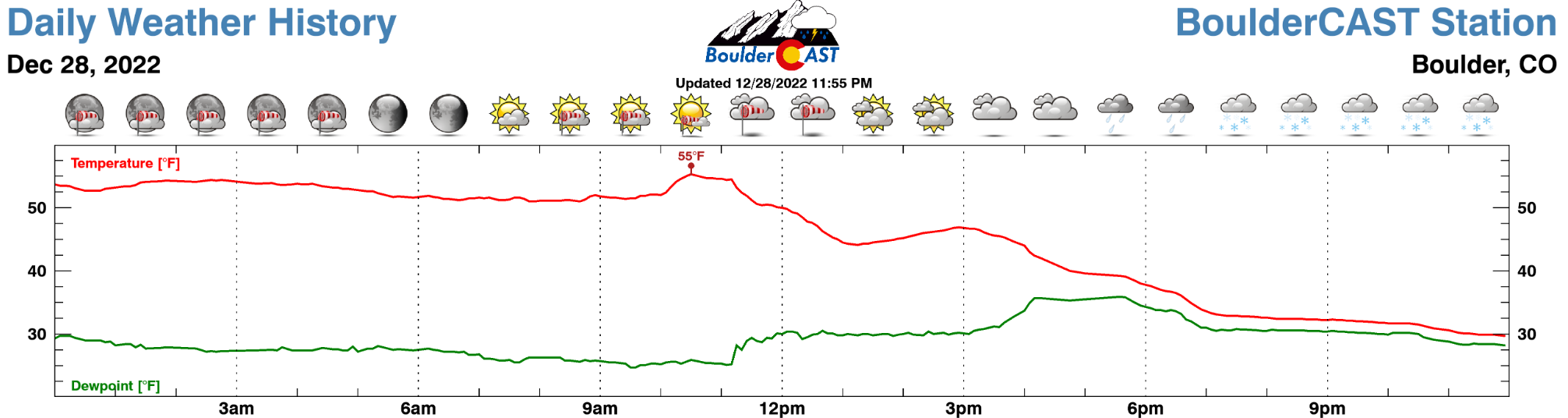
Despite being off by a factor of two for snow amounts in many locations, the broader aspects of the storm did play out as we had anticipated Wednesday evening. Precipitation began with several hours of steady rainfall — something that is extremely rare for the month of December in the Front Range. In the off-instances where rain does fall at the onset, these bigger precipitation events will almost always change-over to snow immediately this time of year. It’s just the nature of the beast here. It’s very hard to get all the ingredients for precipitation together in our area BUT somehow not have the cold air rearing to go. That facet of this storm was remarkable in its own right and should have been more of a red flag to us forecasters. Rainfall began around 3 to 4PM in most locales but did not change-over fully to accumulating snow until around 7PM (and even later in some spots). At our station, we recorded 0.35″ of rainfall before we fully turned over to snow!
Once the rain changed to snow, it dumped for hours, and we really mean dumped. We knew there would be some 2″ per hour snowfall rates with this event, but we did not expect them to be as widespread or as long-lasting as what unfolded Wednesday evening. The radar animation below captures the entire event from the first raindrops to the last snowflakes. As you can see, incredibly heavy snow was falling across nearly the entire Denver Metro area for hours Wednesday night. I dont think we’ve ever seen a situation here where 2″ per hour snowfall was pummeling literally ALL of us simultaneously.
In fact, at one point late in the evening, heavy snowfall with 1-2″ per hour rates encompassed the entirety of northeast Colorado! This was definitely something to behold! There were even numerous reports of lightning mixed in with the snow — though very few reports of actual thunder snow. Big meaty snowflakes will greatly dampen the propagation of thunder, so unless you were very close to the lightning bolt, you likely would only see the faint flashes but hear nothing. It seems there may have been a half-dozen or more lightning strikes based on reports coming out of eastern Boulder County.
As you can imagine, multiple hours of extremely heavy snow really piled up with totals soaring with ease past the upper-bounds of our forecast. At our location, we measured 10″ of snowfall on the grassy surfaces this morning, with almost all of that snow accumulating between 7PM and Midnight — that equates to an AVERAGE of 2″ of snow per hour for FIVE hours. The extended period of heavy snow also led to temperatures dropping faster than expected as the big wet snowflakes “pulled down” colder air from aloft. This compounded the impact of the storm as we had counted on more melting with the event. However, it didn’t take too long for temperatures to drop near or below the freezing mark under those sky-high precipitation rates.
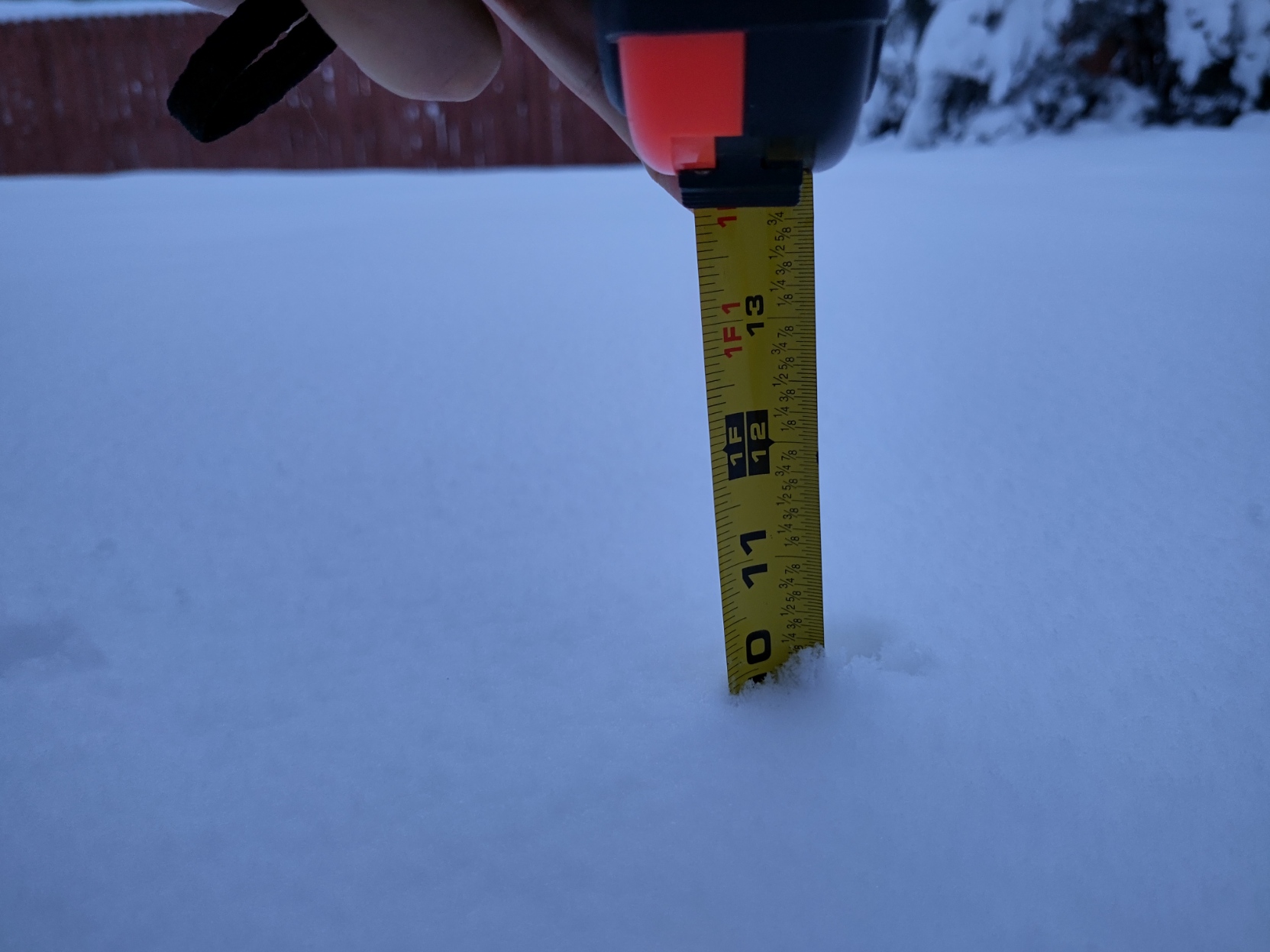
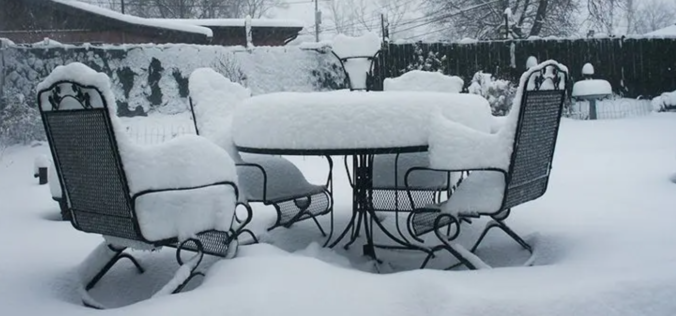
Obligatory tape measure in the snow picture
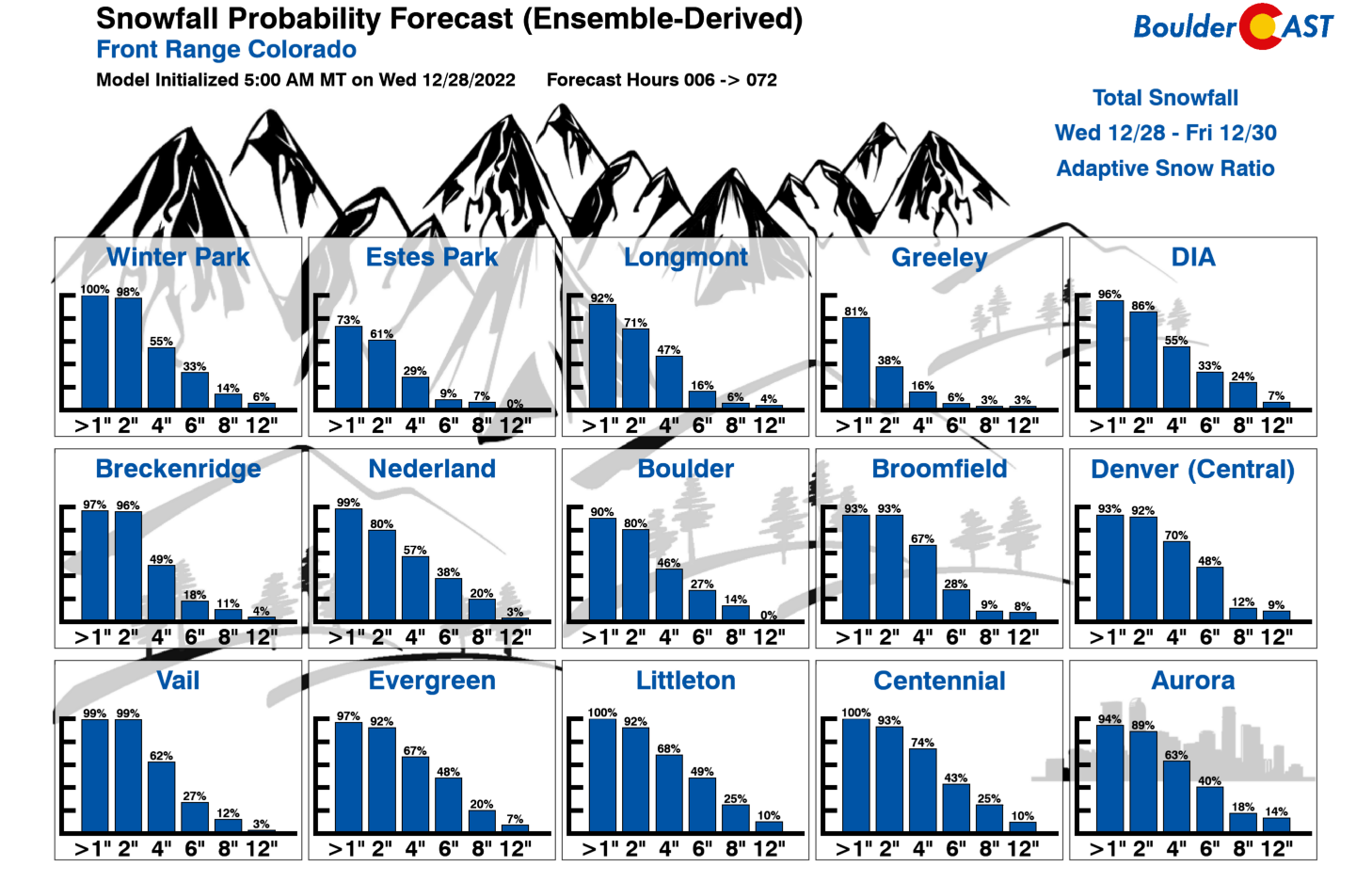
This event was one that the forecast models clearly struggled with, and as a result, just about everyone of us trying to interpret their data struggled as well. None of the global models really indicated this much snow was even possible with this event — at least not until Wednesday morning or afternoon. For example, the GFS ensembles only had about a 10-20% chance for our area to see 8″ or more of snow.
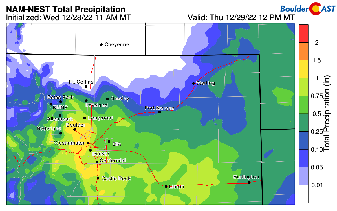
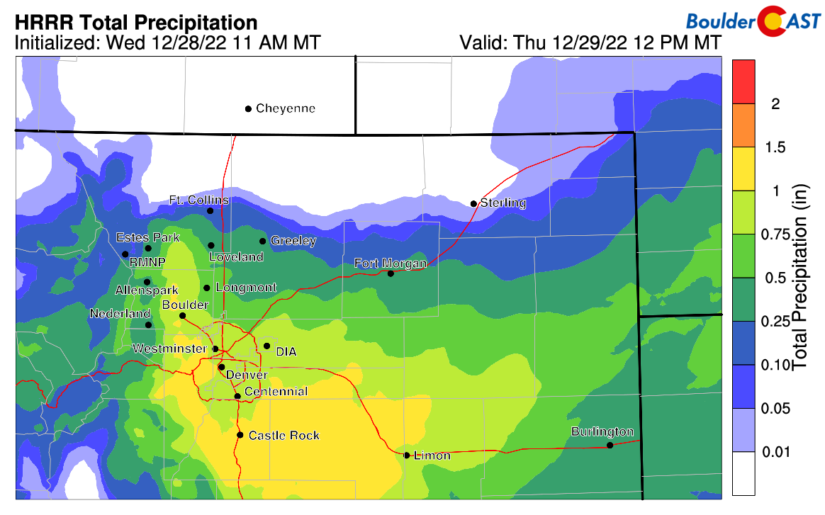
The short-range models really started to indicate this could be a significant event for us, but again, not until about six hours before the precipitation commenced. Despite making a late change, the HRRR and NAM-NEST models more-or-less nailed the event predicting over 1″ of moisture in and near the Foothills:
We posted our final thoughts on the storm (in a Premium update) just before things began. We reminded folks that uncertainty was still high, but suggested that booming snowfall totals were much more likely than lower ones. We even noted some eerie similarities between this impending event and one that dumped a foot of snow across the Denver area nearly three years ago. Ultimately though, we believed things were still too uncertain to make any major forecast adjustments, especially at this very last minute.
Looking back — should we have increased snowfall totals late in the day Wednesday? Probably, but hindsight is always 20-20 as you know. There’s absolutely no way our team or anyone could have predicted the deluge of snow about to unleash on the Front Range. There were NO winter weather highlights issued by the National Weather Service for the Denver-Boulder area until early afternoon on Wednesday. Before that, some folks may have had no idea what was coming. They didn’t even upgrade us to a Winter Storm Warning until heavy snow was already falling and it was clear it would be sticking around for many more hours into the night. Not pointing the finger here of course, but this does speak to just how suddenly this major snow event landed on our door.
Furthermore, there’s no forecast adjustment we would have realistically made that would have resulted in excellent forecast verification for this storm. Yes the global models were trending upward. Yes the short-range models were producing almost comical amounts of moisture. But those types of things happen with a lot of storms actually — without us even mentioning it sometimes. It’s a local meteorologists job to learn when to ignore outliers and when follow them. Nailing that decision-making process down takes years of experience forecasting weather for a given area. This time we made a bad call and we are certainly owning up to it. Despite the incredible tools available to us these days, you have to remember that forecasting the weather is literally predicting the future. There’s often a loft of uncertainty and a variety of scenarios we know can happen from a given weather setup — each storm is always slightly different which makes it ever-challenging. For snowfall forecasts specifically, our general goal for each location is to capture about 80% of the potential outcomes within our snowfall forecast ranges. Sometimes there are more factors and uncertainty in play, and thus the ranges can be larger. Sometimes the uncertainty is so high like it was last night, the snowfall forecast range would become so large if we still wanted to capture 80% of outcomes. Basically to get that for this past storm we would have needed to say 2-10″ for Boulder. That range is clearly not helpful, so we made a judgement call to stick with our original forecast knowing that we had a good chance of being too low — and you know the rest.
BoulderCAST Subjective Snowfall Range Probabilities for this event in Boulder
- 0-2″: 10%
- 2-6″: 60%
- 6-10″: 20%
- 10″+: 10%
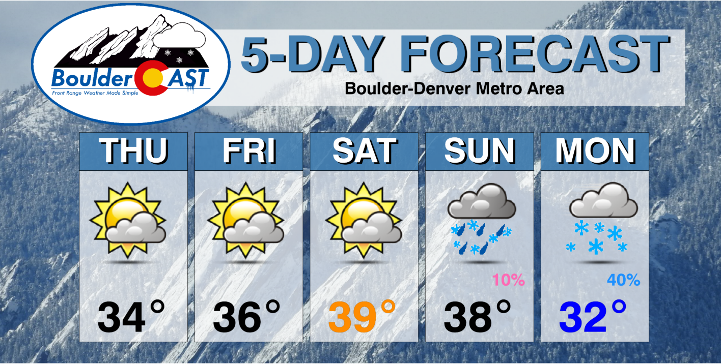
For now, enjoy the beautiful winter wonderland out there. Take it easy on the roads and with shoveling — this is our first “sludge” snow of the season and it’s no joke! Plan for a chilly holiday weekend ahead with our next chance of snow already shaping up for Sunday night into Monday!
We discuss Boulder and Denver weather every single day on BoulderCAST Premium. Sign up today to get access to our daily forecast discussions every morning, complete six-day skiing and hiking forecasts powered by machine learning, access to all our Front Range specific weather models, additional storm updates and much more!
.
Spread the word, share Colorado’s crazy weather:


You must be logged in to post a comment.