The first week of February starts off dry and mild as high pressure ridging and downslope flow will develop across the Front Range helping to chip away at the fresh, sloppy snowpack. A midweek system will favor mode cloud cover and winds, along with a low-end chance of rain or snow, though these will mostly be confined to the higher terrain. A better chance of snow and colder temperatures appears to come Friday or Saturday with most guidance suggesting a favorable storm track for our area. Read on as we discuss this and more in our weekly outlook.
This week’s highlights include:
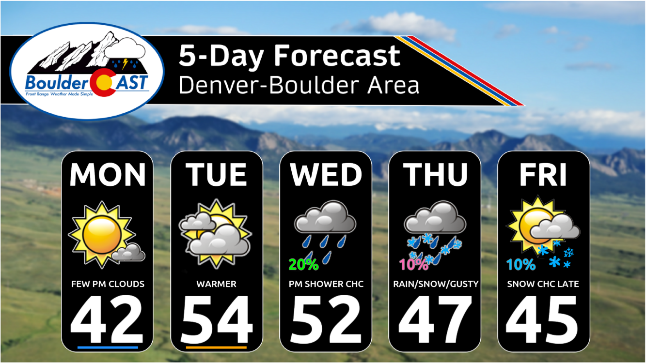
- A mild and dry start to the week with 40s to 50s, some areas with less snow cover may even reach the lower 60s
- A midweek system brings an increase in west-northwest winds and a low-end chance of rain or snow Wednesday night and Thursday
- A better chance of snow is possible Friday or Saturday with a more favorable storm track — though uncertainty remains in its timing and location
- Mild temperatures should trend cooler into the 30s by the start of the weekend
DISCLAIMER: This weekly outlook forecast is created Monday morning and covers the entire upcoming week. Accuracy will decrease as the week progresses as this post is NOT updated. To receive daily updated forecasts from our team, among many other perks, subscribe to BoulderCAST Premium.

Go Premium, get all the perks.
Daily Forecast Updates
Get our daily forecast discussion every morning delivered to your inbox.
All Our Model Data
Access to all our Colorado-centric high-resolution weather model graphics. Seriously — every one!
Ski & Hiking Forecasts
6-day forecasts for all the Colorado ski resorts, plus more than 120 hiking trails, including every 14er.
Smoke Forecasts
Wildfire smoke concentration predictions up to 72 hours into the future.
Exclusive Content
Weekend outlooks every Thursday, bonus storm updates, historical data and much more!
No Advertisements
Enjoy ad-free viewing on the entire site.
Quiet and mild to start
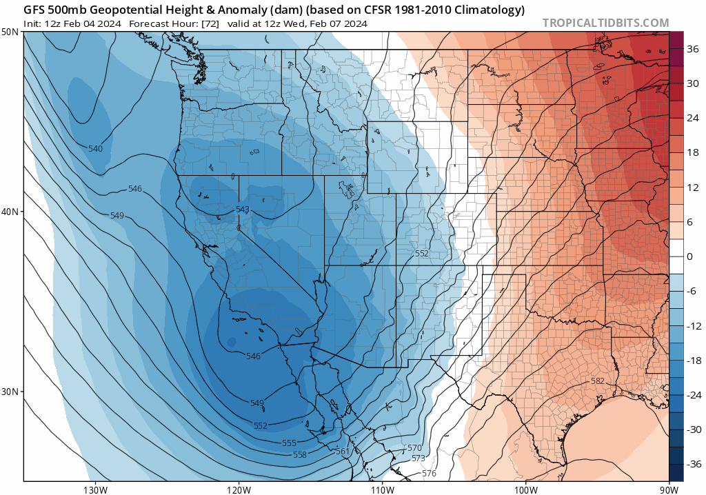
After a rather active weekend with a moderate to significant snowstorm in the Front Range, this week will start out much quieter, and also warmer! Shortwave ridging will begin the week, followed by a few quick-moving troughs that will impact the state in the middle to latter part of the week and weekend ahead. The ridging will bring downslope warming for the first half of the week, but trough passages will usher in cooler to more seasonal temperatures by the end of the week with perhaps things trending below normal for weekend. The GEFS temperature forecast shows that Tuesday could be our warmest day with middle 50s to perhaps some low 60s!
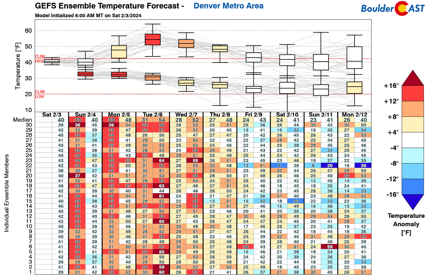
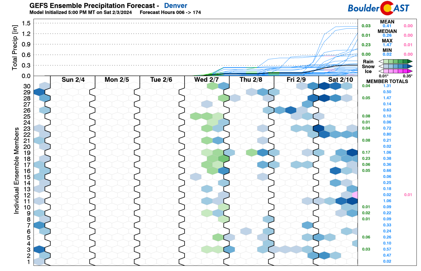
Based on a suite of model data, including the GEFS below, our week also starts off dry, in addition to the mild temperatures. There is a low-end chance of some rain or brief snow showers Wednesday and Thursday with our first trough passage, but all guidance so far favors just a minor threat. While there is a fair bit of model spread, the better chance of snow for us appears sometime Friday or even Saturday night into Sunday. We’ll touch on this later in the post.
Compared to highs in the 30s on Saturday, our Monday starts off much better with upper 40s. Even some parts of Denver may approach 50 degrees! There will likely be a fair bit of high temperature spread based on lingering soupy snow cover from the low 40s to upper 40s. A trough today off the California coast will be a concern for us late Tuesday into Wednesday — this system contains an atmospheric river and is bringing major flooding to California right now. For the Front Range, however, expect lots of sunshine Monday with only a few passing high clouds.
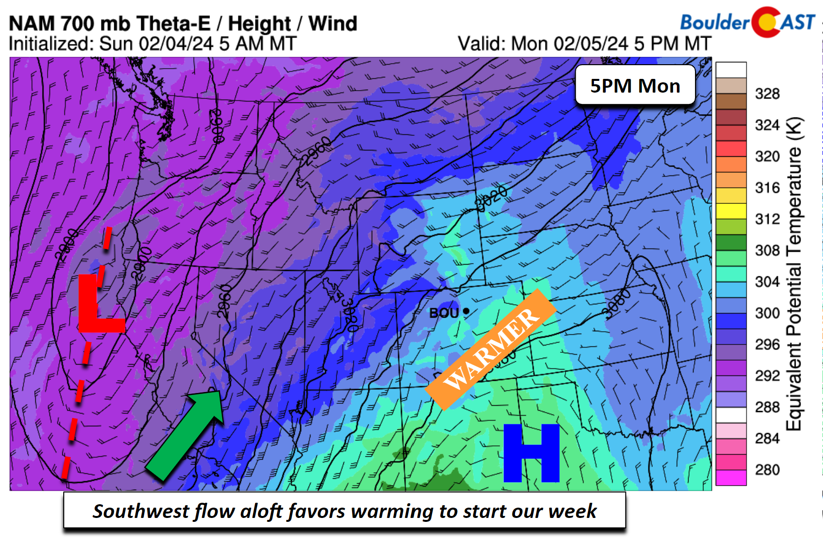
Tomorrow, the ridging will remain in place and the low-level airmass will continue to warm with a more prominent downslope flow pattern. Although snow cover is likely to still linger, we should manage to get into the upper 50s in most areas. Some lower 60s are favored as well, especially regions of the Denver Metro that have less snow cover. The trough out West will take a southeastward track into west-central California by the afternoon. As that happens, moisture will start to build into the southwestern US by the evening.
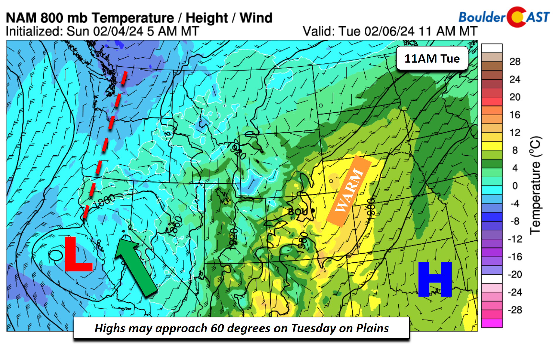
Below shows an animation of the track of the offshore low from Tuesday as it moves from the Desert Southwest early Wednesday morning into the northern Great Plains by Thursday morning. This is at the mid-levels. A surface low is likely to form over the eastern Wyoming to western Dakota region Thursday morning in response to the upper-low. Ahead of the trough, heavy snowfall is favored in the west and southwest mountains of Colorado, starting Tuesday afternoon/evening and continuing into Wednesday before tapering off late Wednesday or early Thursday. Down on the Plains we should stay largely dry on Wednesday and Thursday as the track of this system favors upslope over the higher terrain and downslope for the Front Range. However, we may squeak out some spotty light rain showers Wednesday afternoon. Highs Wednesday look to be about similar to Tuesday, albeit perhaps a few degrees cooler. On Thursday, with the trough moving out, we’ll start to see a cold front inch southward from Wyoming. That could also bring a low-end chance of rain/snow showers Thursday afternoon/evening, but amounts look light, if any. It more importantly looks gusty and cooler Thursday with highs dropping back into the 40s and WNW winds of 20-30 mph.
Below shows the NAM total snowfall through early Wednesday evening. This shows the impact from the aforementioned system Tuesday into early Thursday, showing potential heavy snow totals in the southwest part of the state with favorable upslope in this region.
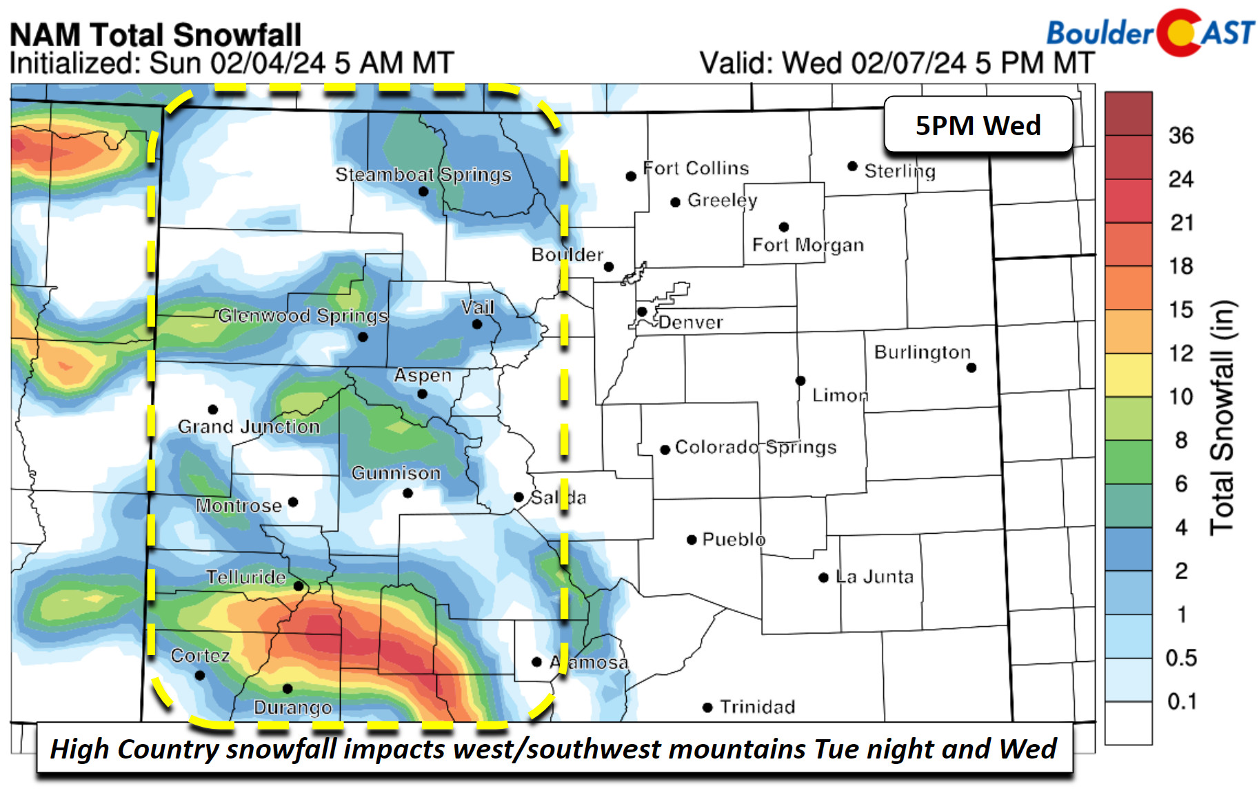
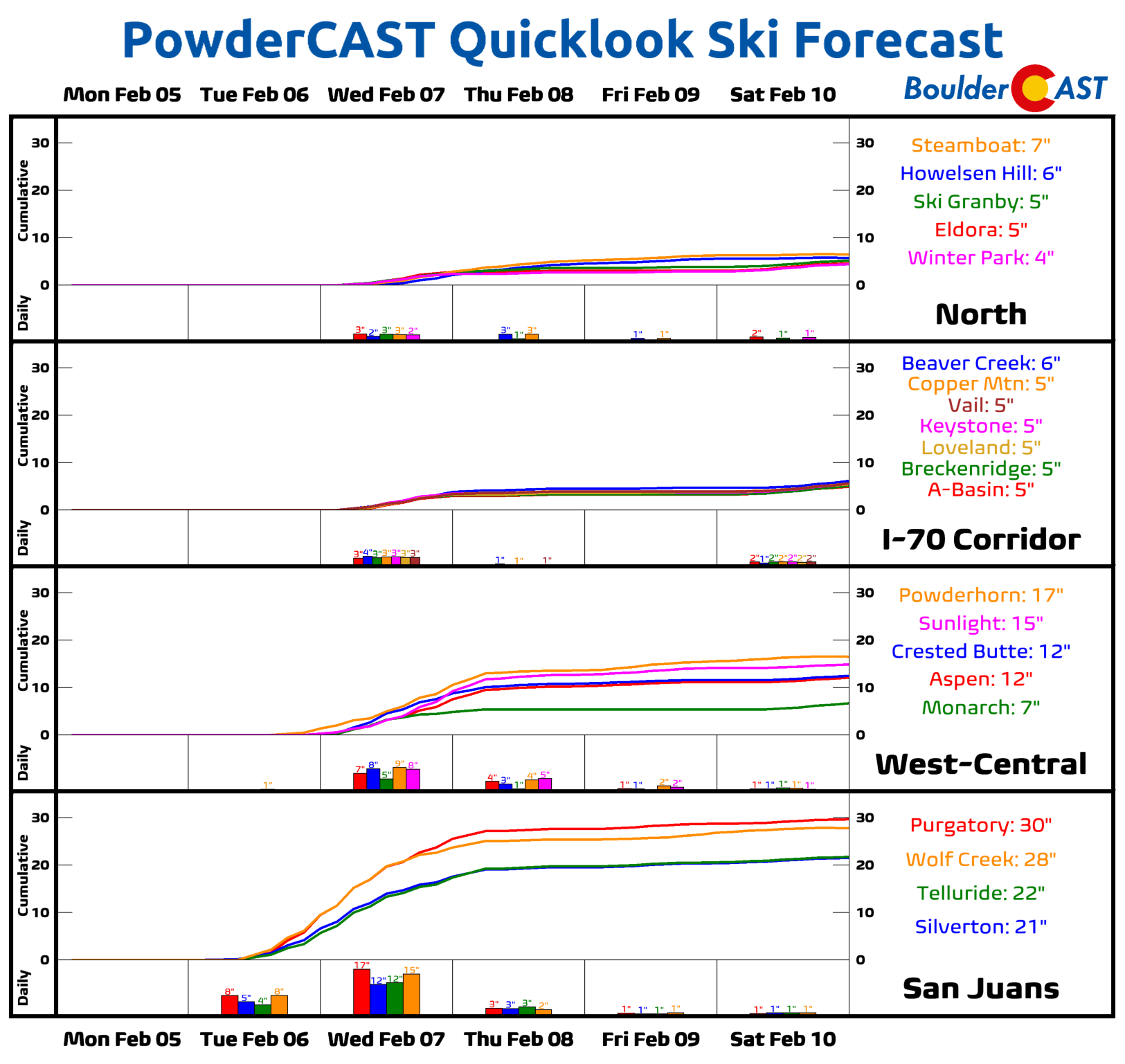
PowderCAST is showing only light snow accumulations across central and northern Colorado resorts this week (boo!), but boy the San Juans are going to get pounded by 1 to 3 feet!
Watching a late-week or weekend storm
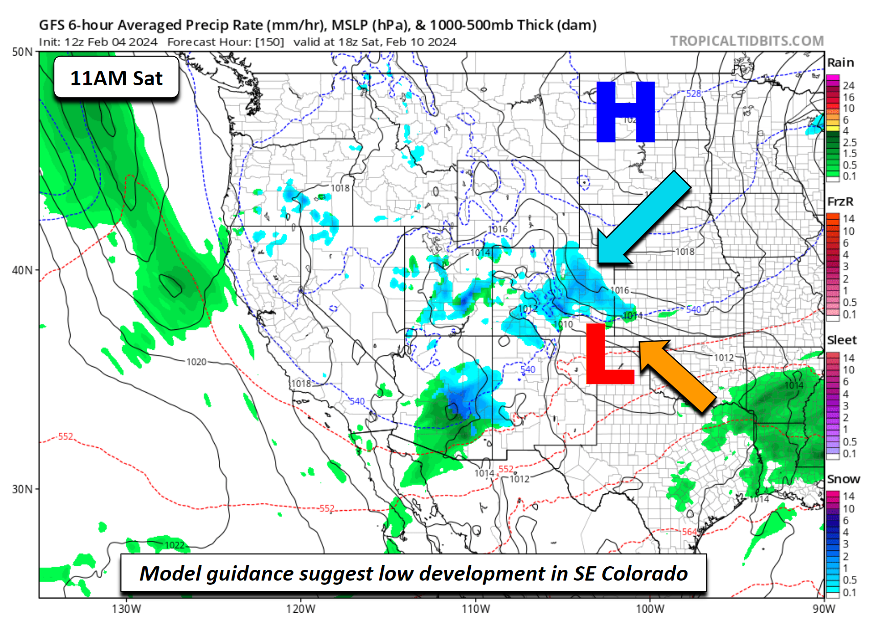
The pattern changes late in the week and upcoming weekend. A look at the range of model guidance shows decent agreement on an area of low pressure forming at or near southeast Colorado this weekend on Saturday. A southward moving cold front and upslope flow behind it could bring a favorable setup for accumulating snowfall. We will likely end the week on the cooler side in the middle 40s as a cold front settles south early Friday with light northeasterly flow. This upslope flow looks to continue into Saturday with cold high pressure either over Montana or the Dakotas. The GFS by midday Saturday shows a secondary trough forming in the Nevada/Utah region and tracking toward the Four Corners this weekend, with a surface low reflection near the Oklahoma Panhandle. This would favor upslope snow in Denver and highs likely at least in the 30s, if not colder.
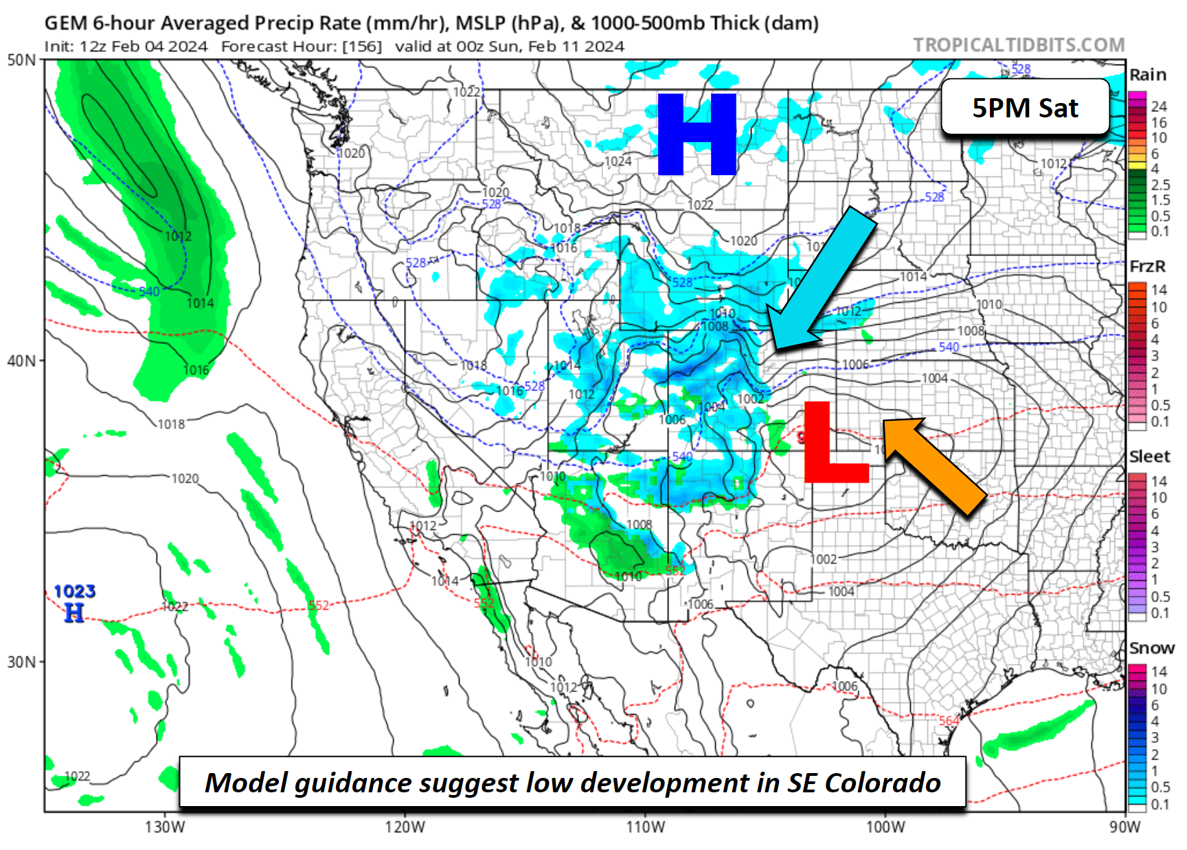
The CMC model from Environment Canada shows an eerily similar synoptic pattern, yet this time it has the surface low a tad further north and west from the GFS over far southeast Colorado. The surface high is over Montana and a stronger upslope flow is evident by the tighter pressure gradient. Both solutions would favor snow for us.
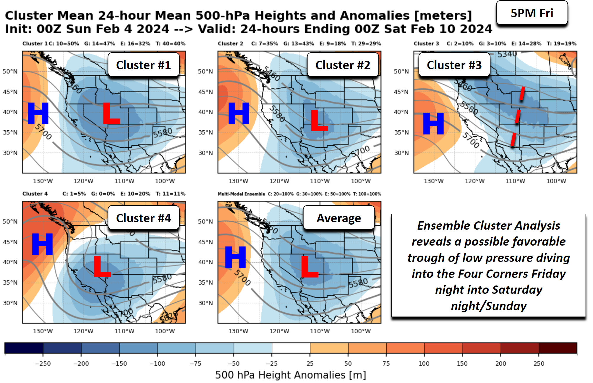
Let’s take a look at the ensemble cluster solutions, which combines 100 ensemble members and 100 possible solutions. Based on all these runs, the top ensemble cluster represents 50% of the CMC ensemble, 47% from the GEFS, and 32% from the ECMWF ensembles. That’s a fair bit of agreement this far out. This top cluster represents 40% of the variability. The 2nd and 3rd solutions are not to be discounted as they also represent nearly 50% of the model spread between the two. All 3 clusters show at least some trough development to our west Friday which tracks eastward this weekend. The first two solutions show a somewhat more developed trough, which could produce similar impacts from what was shown above. Time will tell what ultimately unfolds from this system, but keep it here on BoulderCAST as we get closer.
Have a great week!
Get BoulderCAST updates delivered to your inbox:
Forecast Specifics:
Monday: Mostly sunny and warmer. Highs in the 40s to near 50 on the Plains and middle 30s in the Foothills.
Tuesday: Increasing clouds with highs still warm with 50s to perhaps some lower 60s in the Denver Metro. Highs in the low to mid 40s in the Foothills.
Wednesday: A little gusty with partly sunny skies and a slight chance of evening light rain showers. Highs in the 50s to around 60 degrees. Highs over the Foothills in the middle 40s.
Thursday: Gusty west to northwest winds of 20-30 mph under partly to mostly cloudy skies. A chance of evening light snow showers. Highs close to 50 degrees for the Plains and near 40 in the Foothills.
Friday: Increasing clouds and cooler with a chance of late evening snow showers. Highs in the middle 40s for the Plains and middle 30s in the Foothills.
Weekend: All eyes are on an approaching storm system which could bring our next good shot of snow sometime Saturday into Sunday. Highs will likely be in the 30s, if not lower.
DISCLAIMER: This weekly outlook forecast is created Monday morning and covers the entire upcoming week. Accuracy will decrease as the week progresses as this post is NOT updated. To receive daily updated forecasts from our team, among many other perks, subscribe to BoulderCAST Premium.
Go Premium, get all the perks.
Daily Forecast Updates
Get our daily forecast discussion every morning delivered to your inbox.
All Our Model Data
Access to all our Colorado-centric high-resolution weather model graphics. Seriously — every one!
Ski & Hiking Forecasts
6-day forecasts for all the Colorado ski resorts, plus more than 120 hiking trails, including every 14er.
Smoke Forecasts
Wildfire smoke concentration predictions up to 72 hours into the future.
Exclusive Content
Weekend outlooks every Thursday, bonus storm updates, historical data and much more!
No Advertisements
Enjoy ad-free viewing on the entire site.
Enjoy our content? Give it a share!


You must be logged in to post a comment.