


As we kick off the week, the Front Range is staring down a few more days of stubborn August heat — but that pattern is about to crack. A midweek shift will pull cooler air, deeper monsoon moisture, and widespread storms back into Colorado, including a real shot at heavy rainfall. After weeks of haze, heat, and bone‑dry afternoons, the atmosphere finally looks ready to turn the page. We break down what this transition means for the Boulder-Denver area, and how long the cooler, wetter pattern is poised to stick around.
This week’s highlights include:
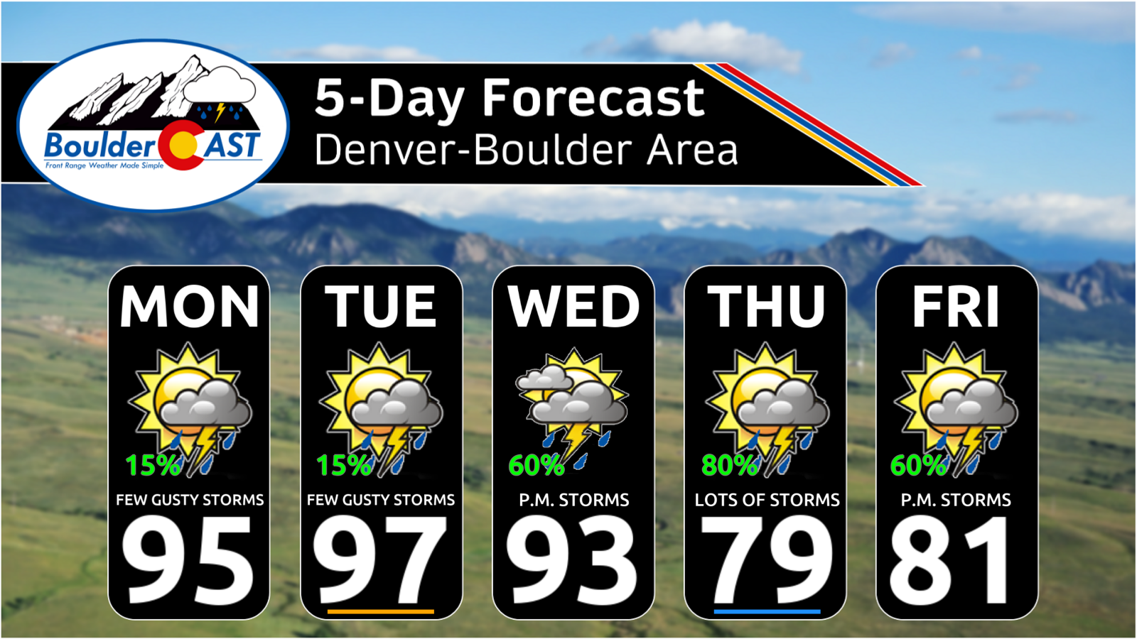
- 🔥 Heat holds through Wednesday with the 90s sticking around.
- 🌤️ Early week high‑based storms stay limited (10–20%) and produce gusty winds but little rainfall.
- 🌫️ Smoke + ozone linger Monday, with gradual improvement beginning Tuesday and especially Wednesday.
- 🏔️ Better storm chances in the Foothills/High Country early in the week.
- 🌧️ Monsoon moisture returns midweek as the ridge weakens and Great Basin troughing develops.
- ⛈️ Widespread storms late-week with 50–80% coverage and cooler highs in the upper 70s–low 80s.
- 💧 Heavy rainfall potential increases Thursday–Friday with anomalous PWAT and efficient storms.
- ⚠️ WPC highlights a Slight flash‑flood risk Thursday across the Front Range and northeast Colorado. This may extend into Friday.
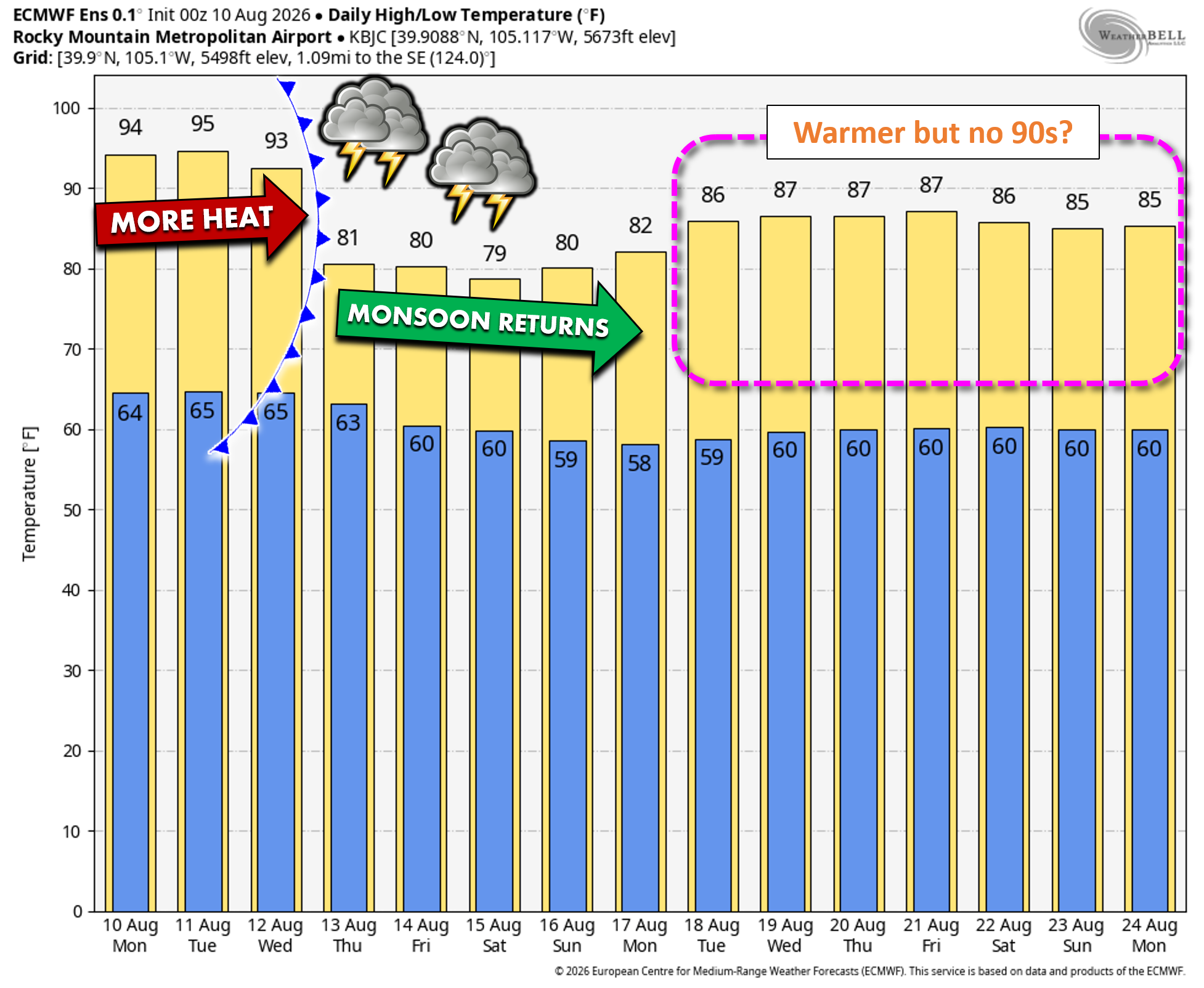
- 🧊 Cooler weather may be here for a while, with no 90s present in ensemble guidance through next week. Amazing!
DISCLAIMER: This weekly outlook forecast is created Monday morning and covers the entire upcoming week. Accuracy will decrease as the week progresses as this post is NOT updated. To receive daily updated forecasts from our team, among many other perks, subscribe to BoulderCAST Premium.

Go Premium, get all the perks.
Daily Forecast Updates
Get our daily forecast discussion every morning delivered to your inbox.
All Our Model Data
Access to all our Colorado-centric high-resolution weather model graphics. Seriously — every one!
Ski & Hiking Forecasts
6-day forecasts for all the Colorado ski resorts, plus more than 120 hiking trails, including every 14er.
Smoke Forecasts
Wildfire smoke concentration predictions up to 72 hours into the future.
Exclusive Content
Weekend outlooks every Thursday, bonus storm updates, historical data and much more!
No Advertisements
Enjoy ad-free viewing on the entire site.
A Hot Summer It Has Been
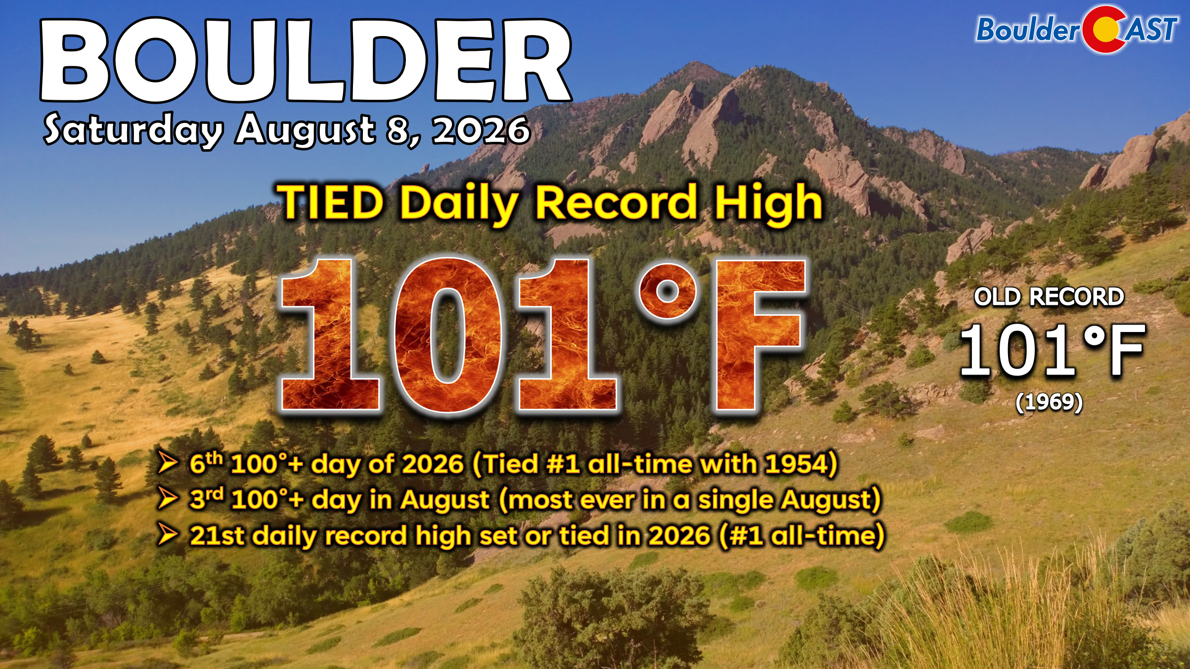
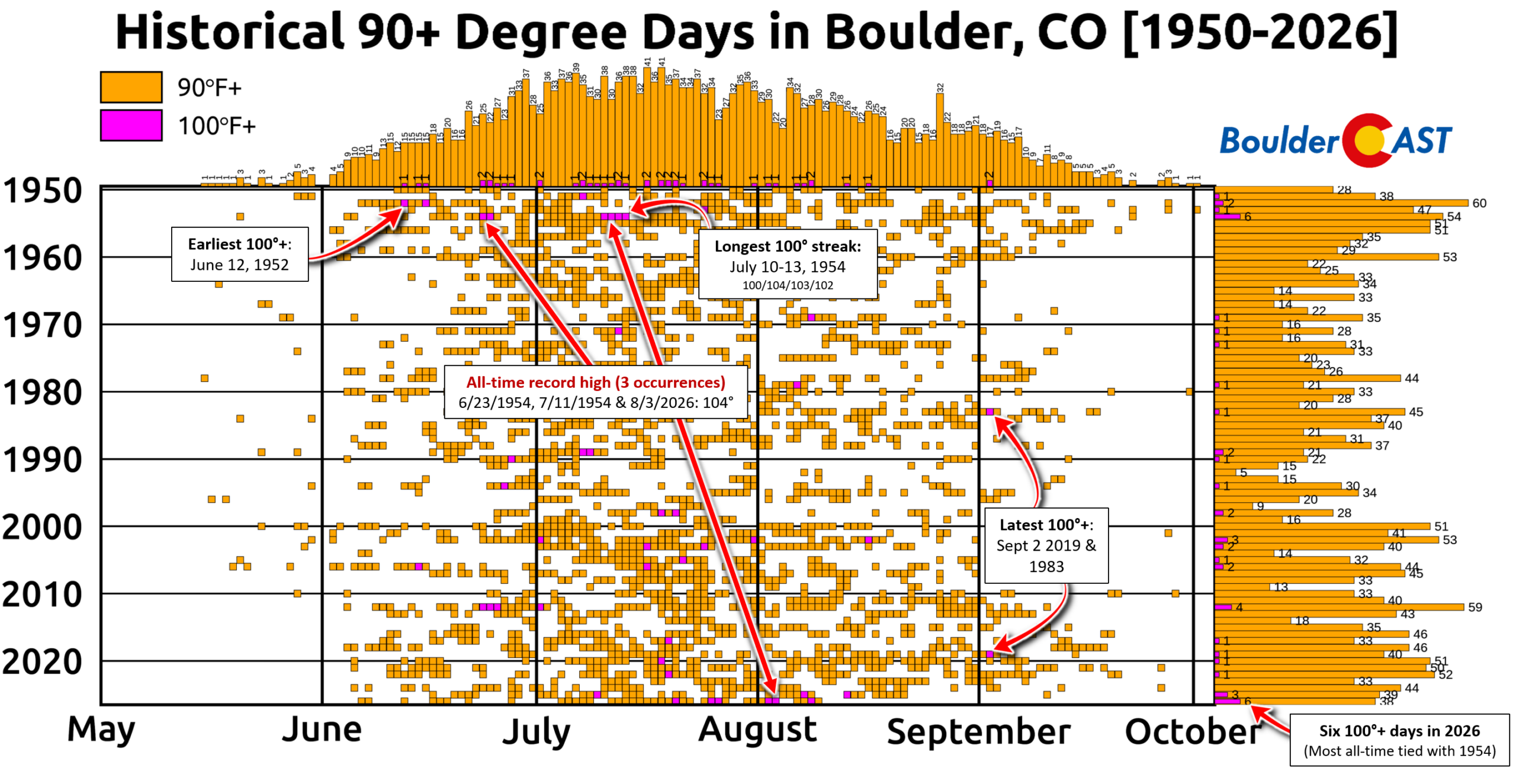
The weekend kept the hot weather rolling across the Front Range, with Boulder tying a daily record high temperature on Saturday peaking briefly at 101°F. This was our 6th 100°+ day of the summer, tying 2026 with 1954 for the most in a single year. This was also our 3rd 100°+ day in August, breaking the record of 2 set just last year.
There’s now been 38 90° days in 2026 which is way above normal. We’re currently tracking above any prior summer in the last decade through August 9th, with plenty of 90° weather still to come the rest of the month and in September.
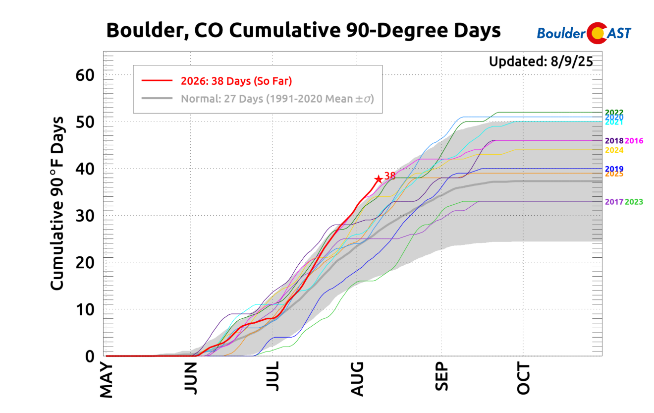
Starting around the Fourth of July, the heat has been relentless in the Front Range, but as we will discuss below, that is about to change…
Heat Holds Strong into Tuesday
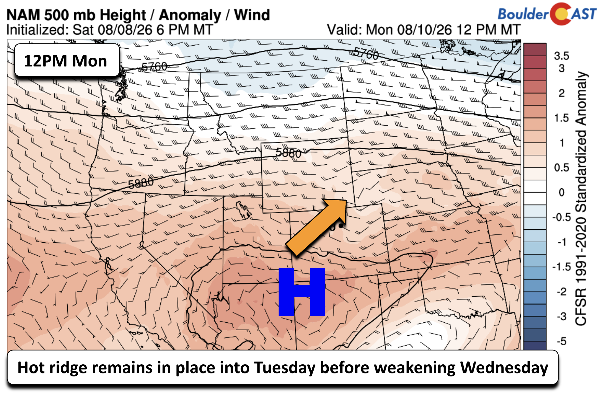
A stout, stagnant ridge remains parked over the Four Corners region, locking the Front Range into another couple days of anomalous August heat under moisture-limited westerly flow.
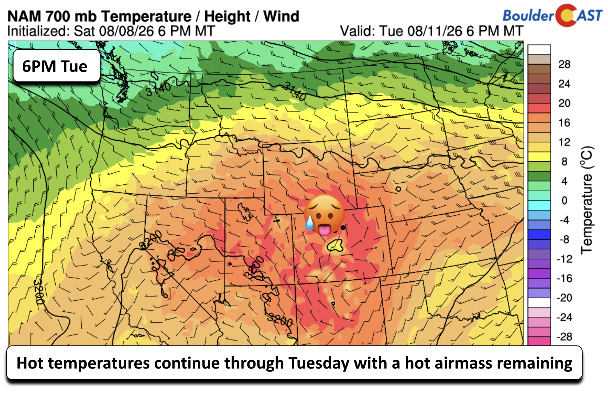
The 700mb airmass is largely unchanged from Sunday, staying warm enough to suppress most convection and maintain the uncomfortable temperature regime.
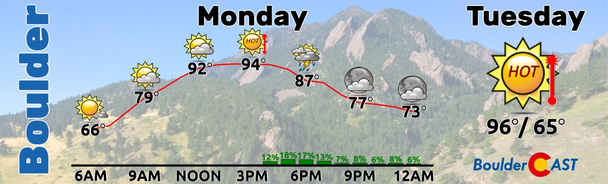
Expect highs in the mid to upper 90s both Monday and Tuesday. A few of the hotter pockets could briefly tag 100°F, but that will not be widespread. Skies trend partly to mostly cloudy with only ~10-20% coverage of high‑based, late‑day storms. Any cells that do form will be moisture‑starved, producing gusts to ~40 MPH and just minimal rainfall.
Smoke & Ozone: Still An Issue
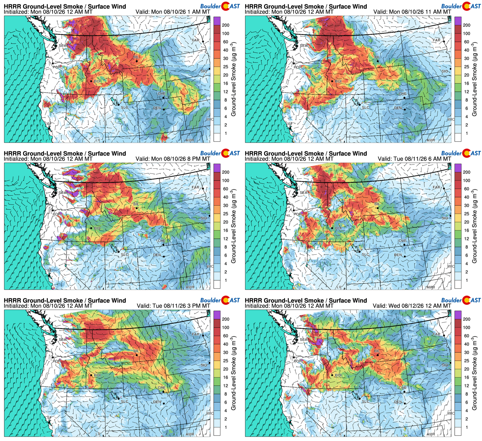
Ground-level wildfire smoke from the Pacific Northwest and ozone are expected to linger Monday as flow remains light over Colorado and holds onto a slight northwesterly component. However, as we head into Tuesday and especially Wednesday, we should start to see an improvement in air quality, both due to storm chances picking up, but also slightly better flow.
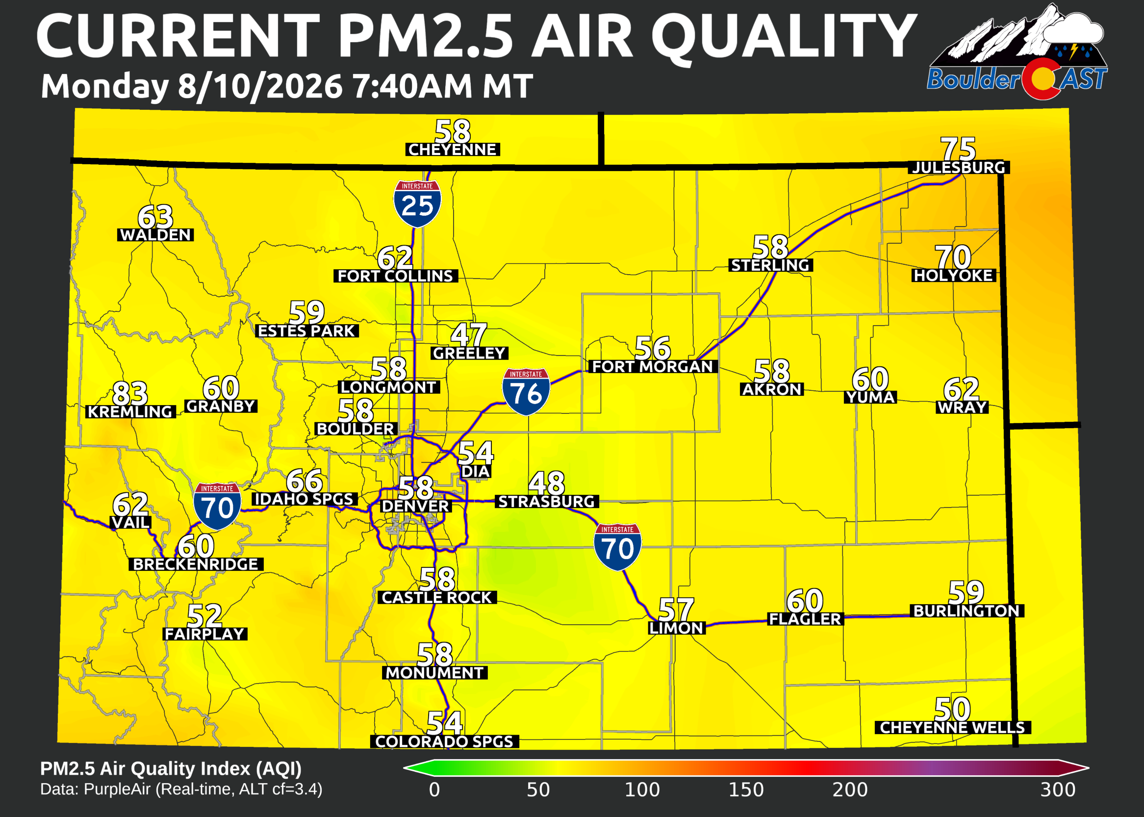
As of Monday morning, PM2.5 air quality remains in the lower end of the Moderate range for most of the area.
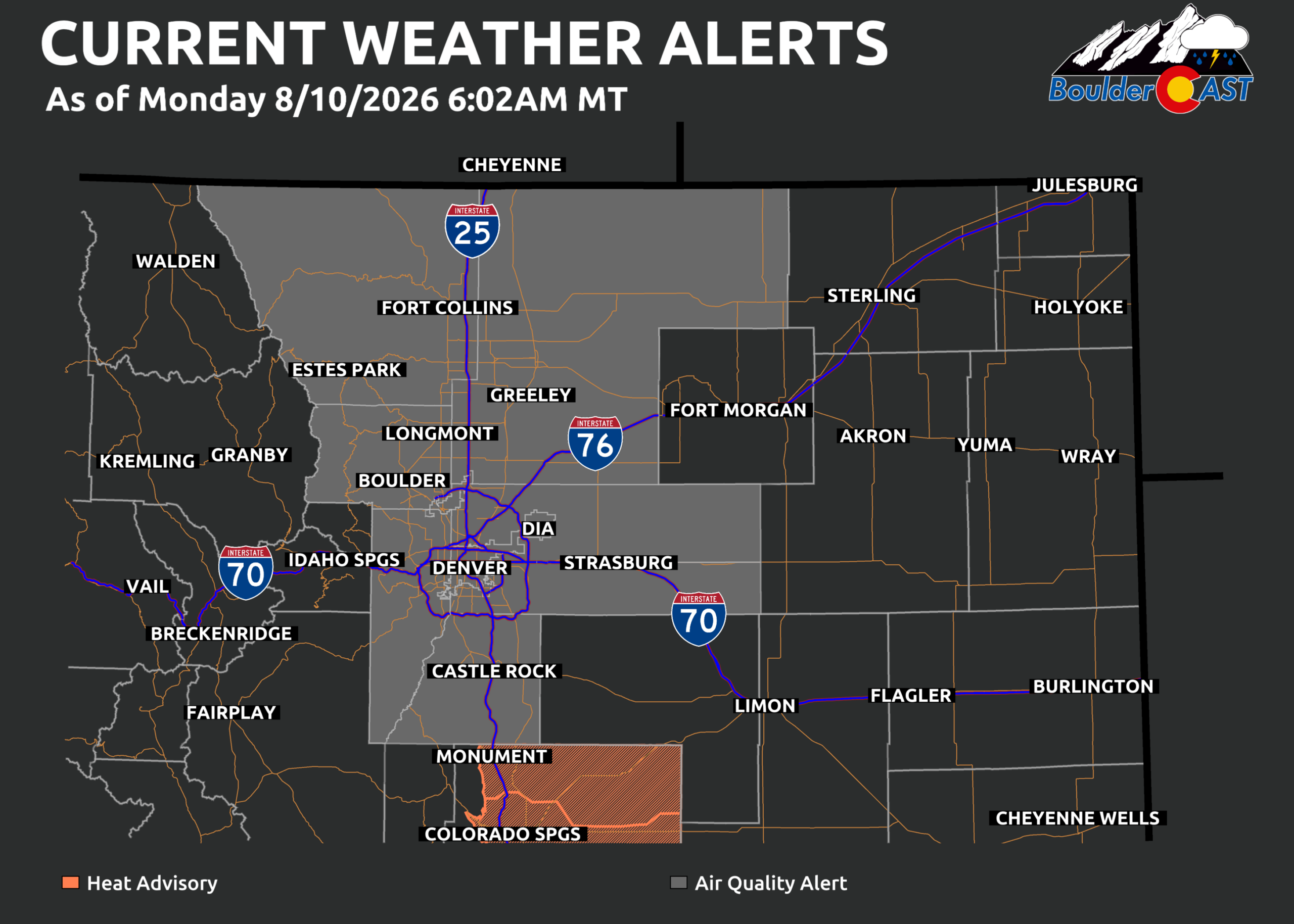
Air Quality Alerts — which have been nearly continuous in the Front Range for the last six weeks — will remain in effect through Tuesday, with a likely drop later in the week as the pattern shifts.
Storm Coverage: Limited Early in the Week
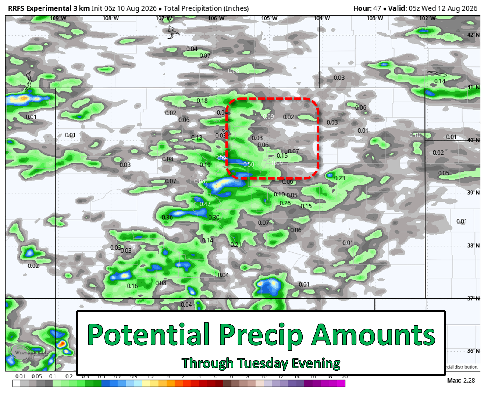
Monday and Tuesday remain mostly dry for the Plains with only 10–20% storm chances, highest over the Foothills and High Country where terrain-driven lift can overcome this ridge more effectively. Precipitation amounts will be light across the lower elevations, generally a few hundredths of an inch or less through Tuesday, but up to 0.15″ in the luckiest spots.
Cooling Off Midweek as Monsoon Returns
A meaningful pattern change will arrive Wednesday. The hot ridge weakens and slides southeast toward Texas while broad troughing expands into the Great Basin. This realignment opens the door for true monsoonal flow to return — deeper moisture, better instability, and embedded disturbances to enhance lift.
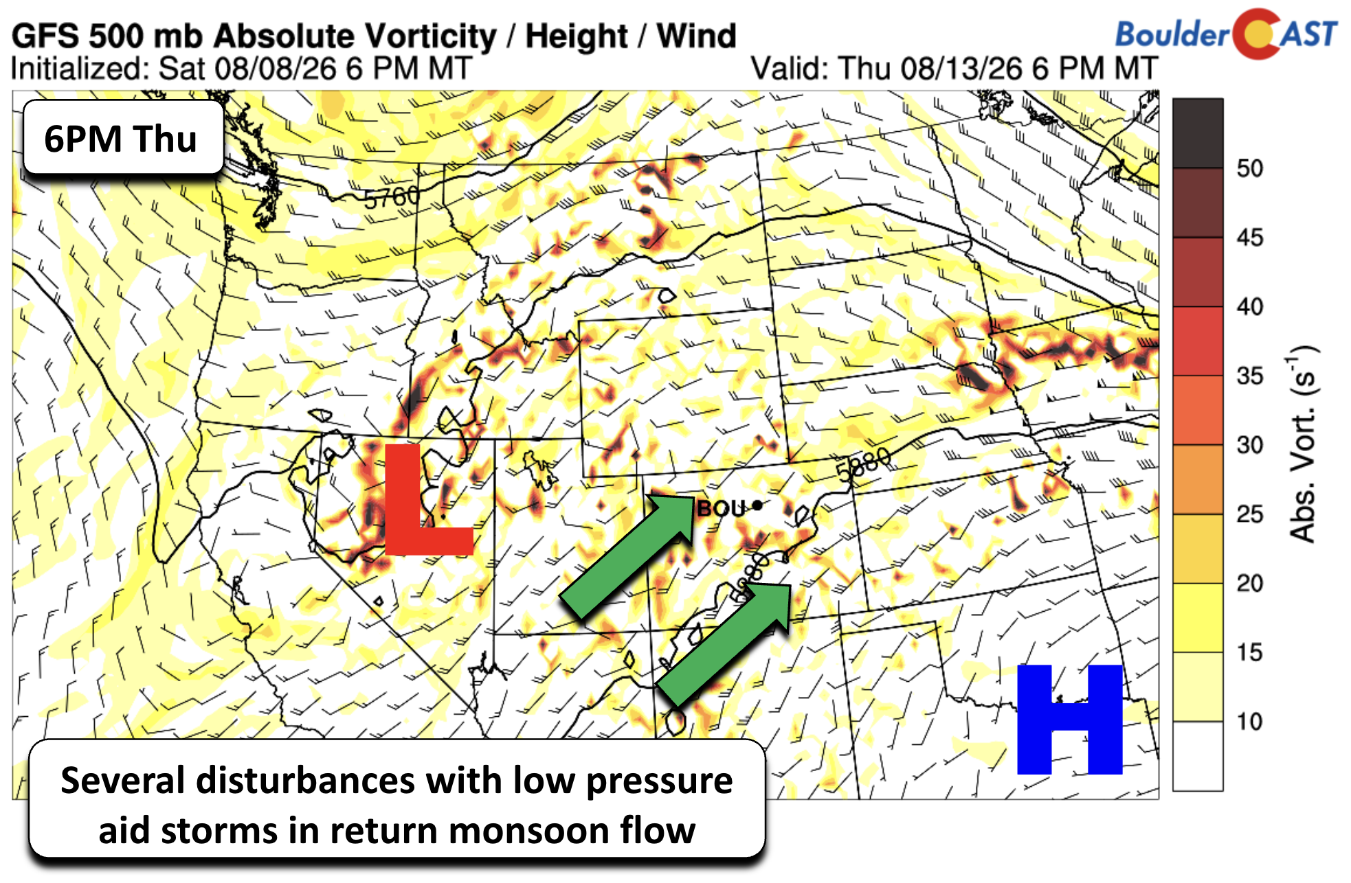
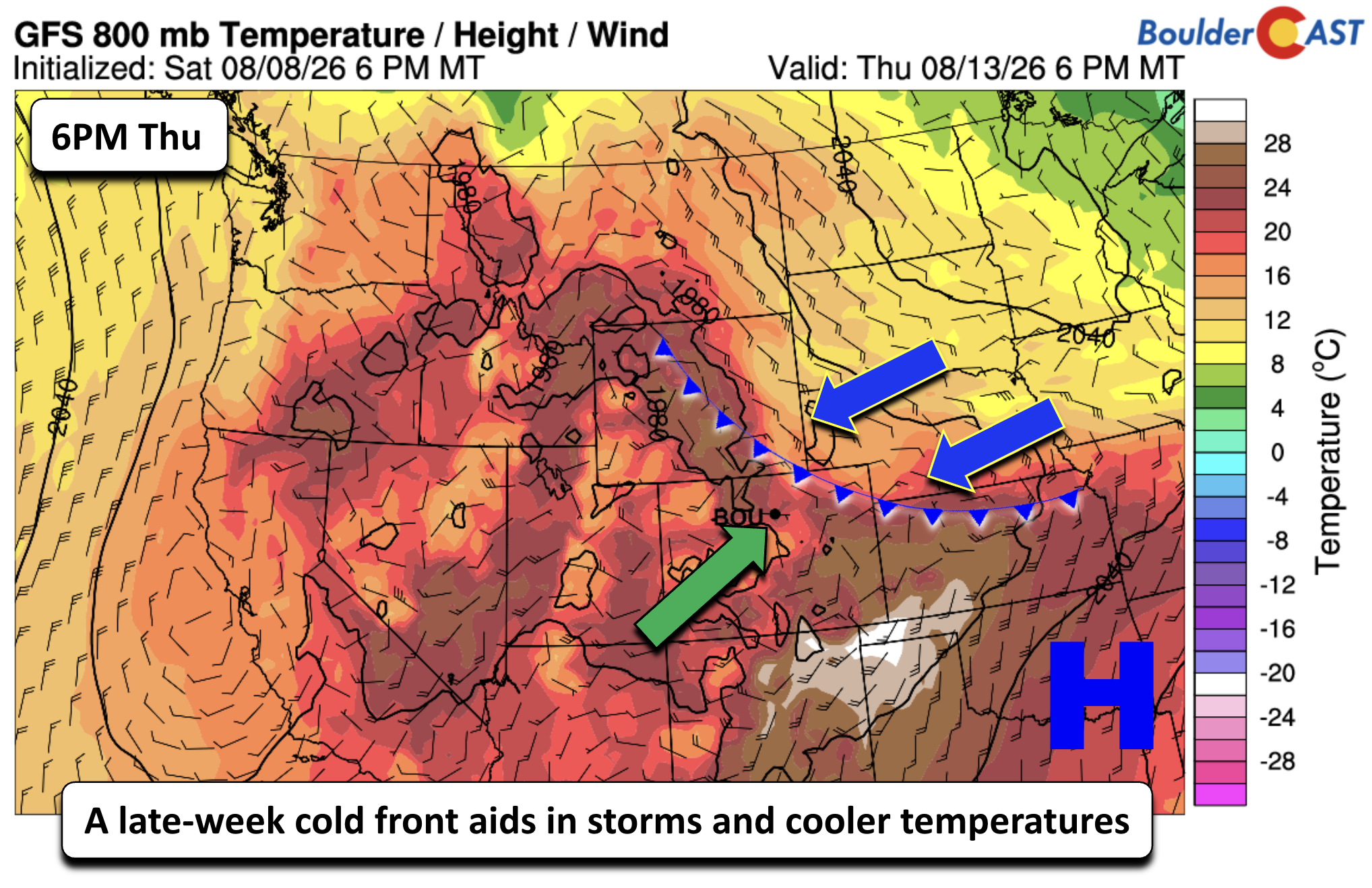
Storm coverage increases sharply Wednesday through Friday, peaking Thursday–Friday as a shallow cold front approaches. Even if the front doesn’t fully push through, its presence will enhance low‑level convergence and mid‑level forcing across northeast Colorado. Expect 50–80% storm chances with highs dropping into the upper 70s to lower 80s — likely coolest Thursday and Friday when monsoon moisture is set to maximize.
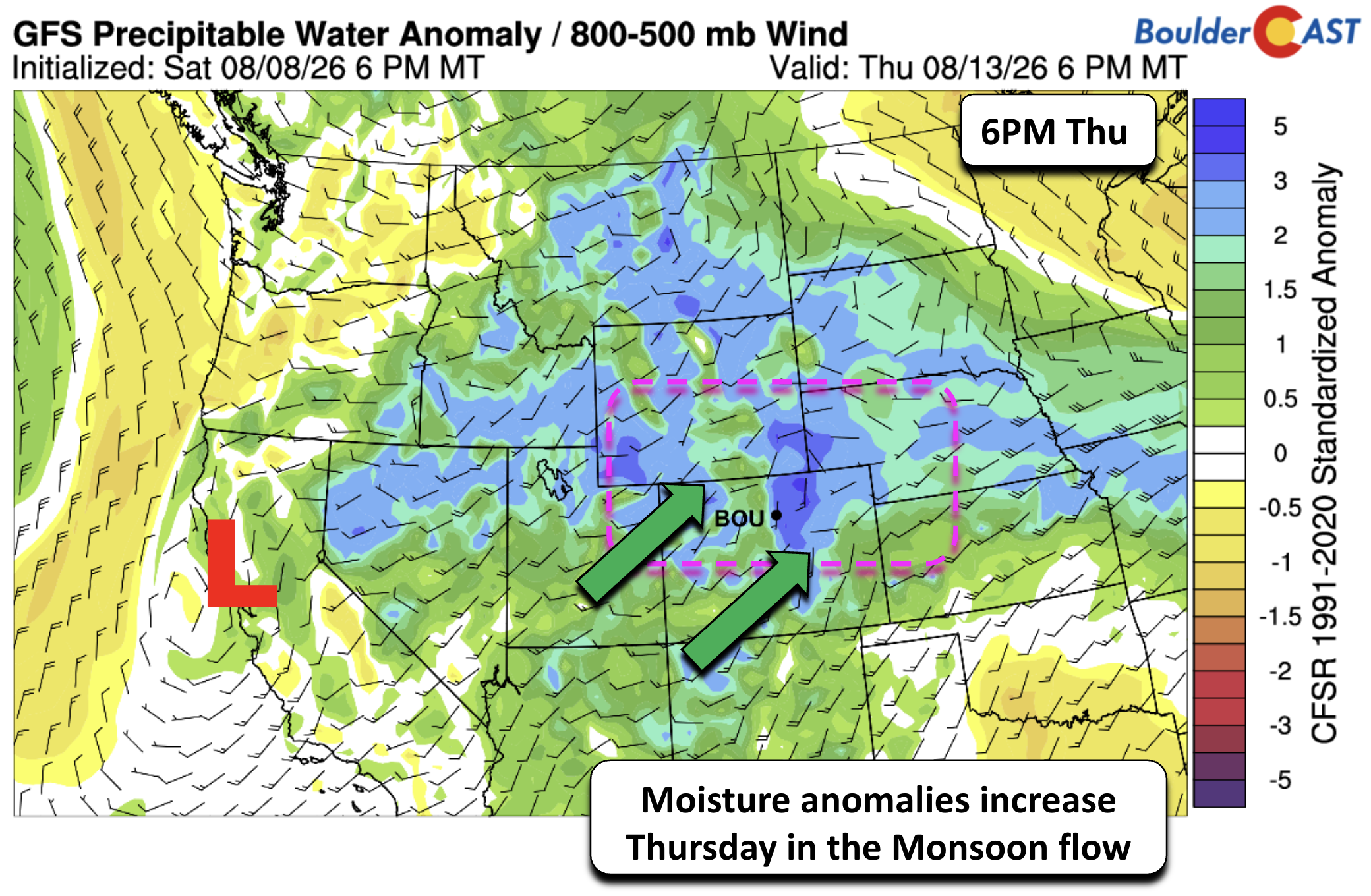
Precipitable water values will surge to well above climatology Thursday as monsoon moisture interacts with mid‑level disturbances and the surface boundary. This combination will support efficient rainfall production and localized heavy totals.
The Weather Prediction Center currently highlights a Slight Risk (Level 2/4) for flash flooding Thursday across the Front Range and much of Colorado.
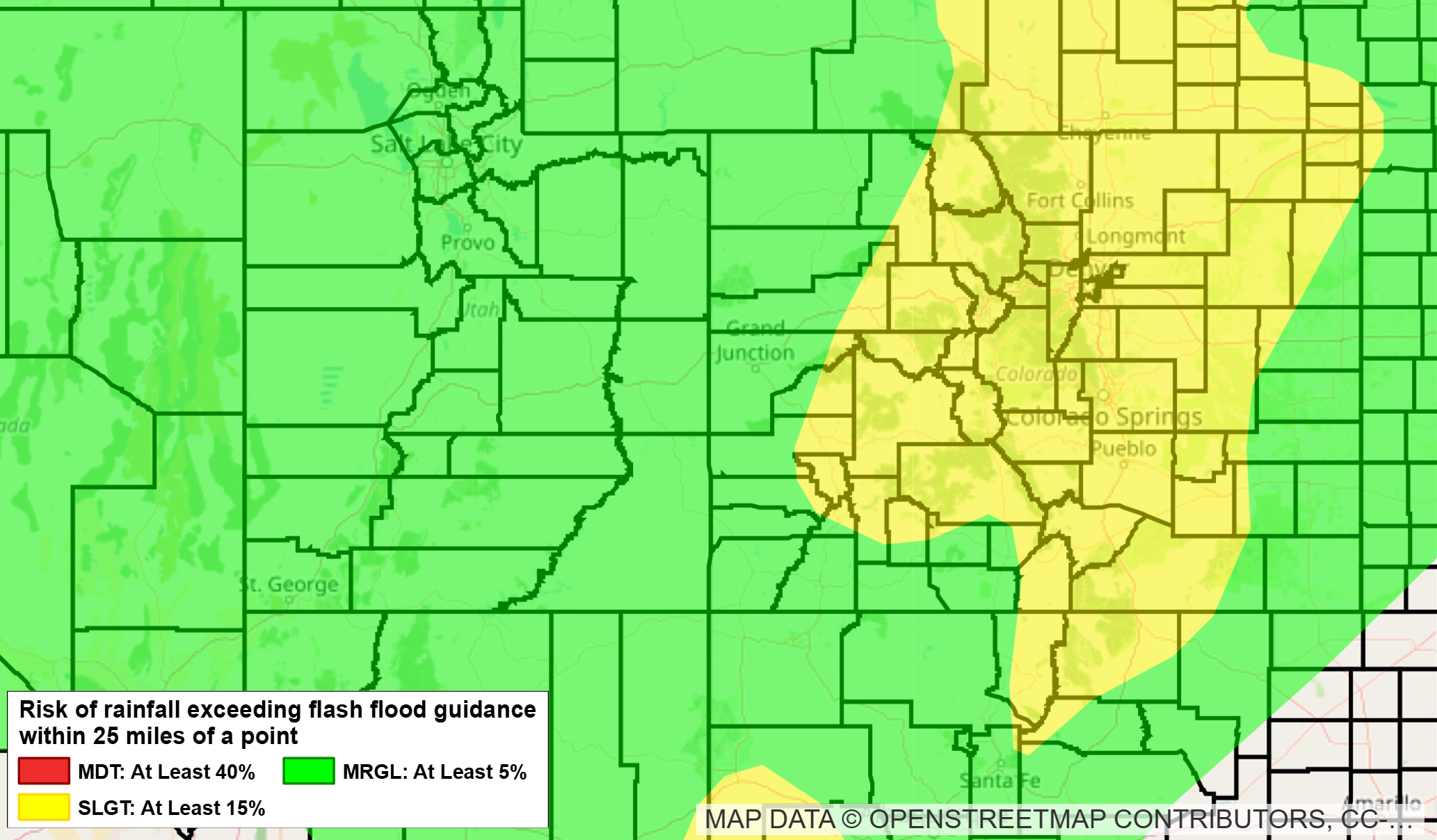
Conditions may change between now and then, but this outlook generalizes the wet pattern in store for us later this week.
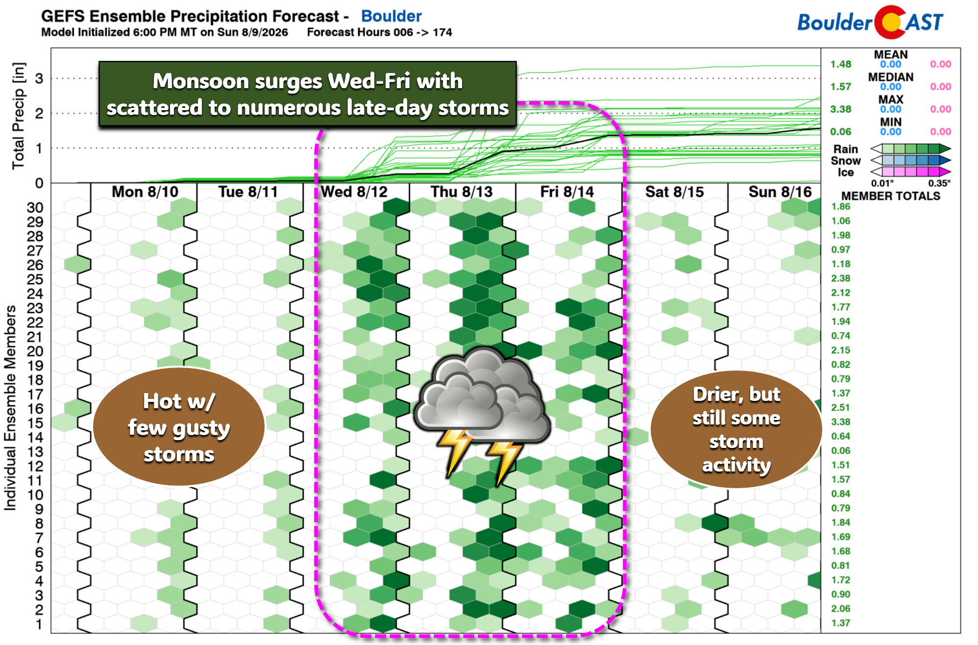
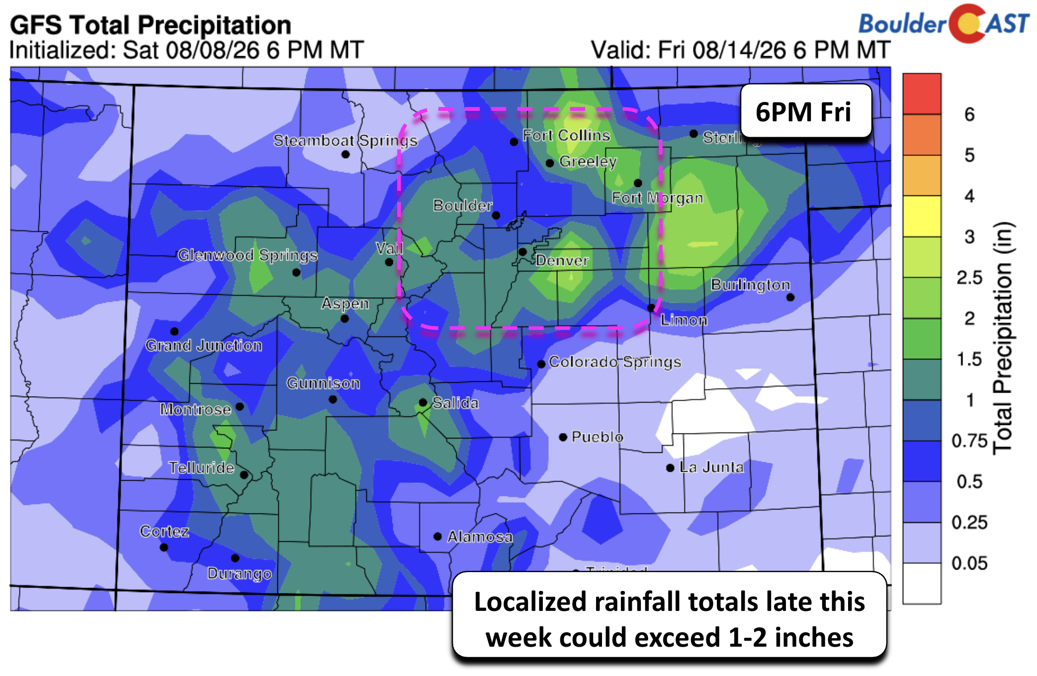
How much precipitation will we see this week? Model solutions vary — as they always do in convective monsoon regimes — but the signal is clear:
- GFS: localized 1–2″+ pockets through Friday
NOAA Weather Prediction Center model blend: broadly ~2″ for the Boulder–Denver corridor.
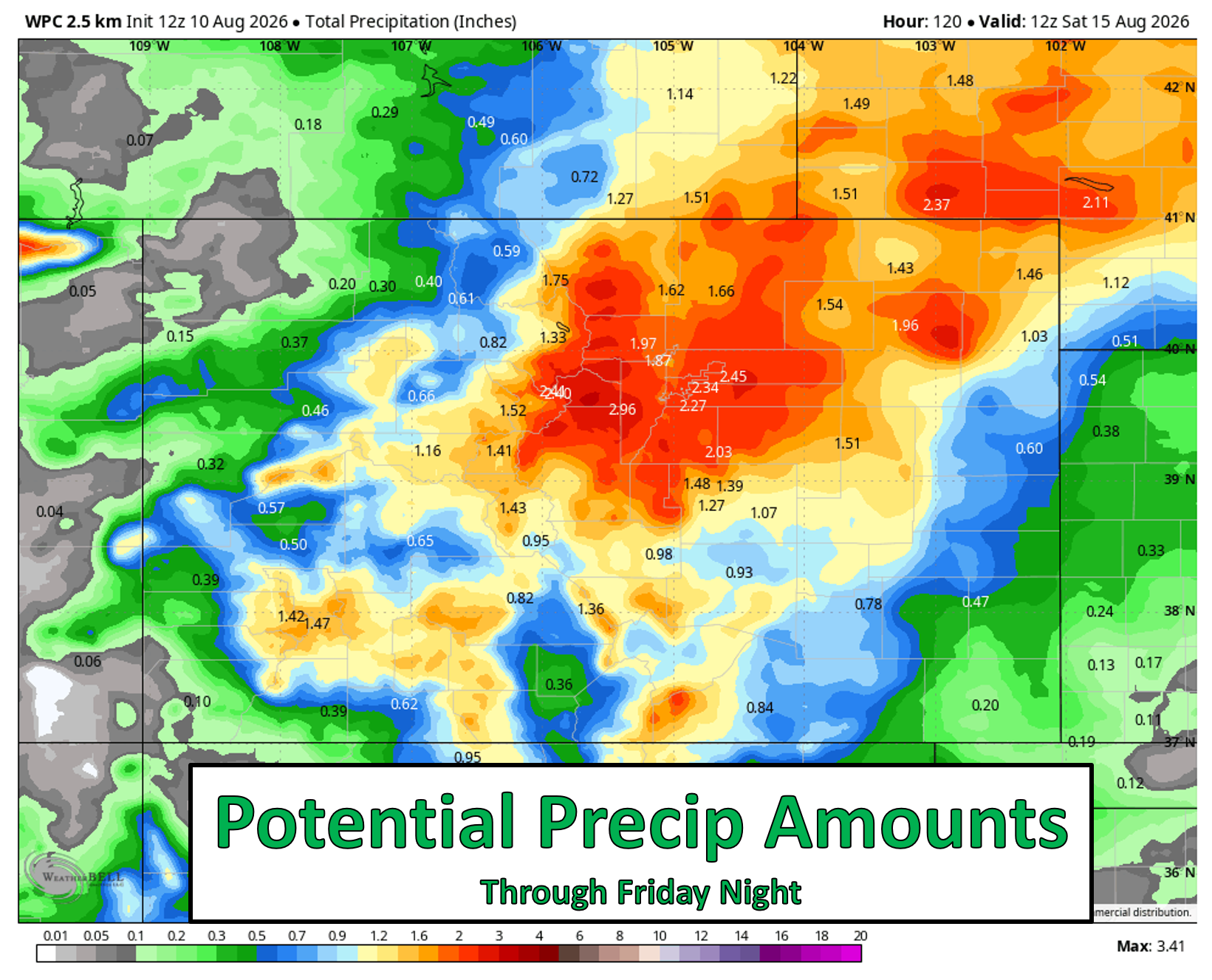
Not everyone will see those numbers of course, but the pattern strongly favors beneficial rainfall and multiple rounds of storms this week.
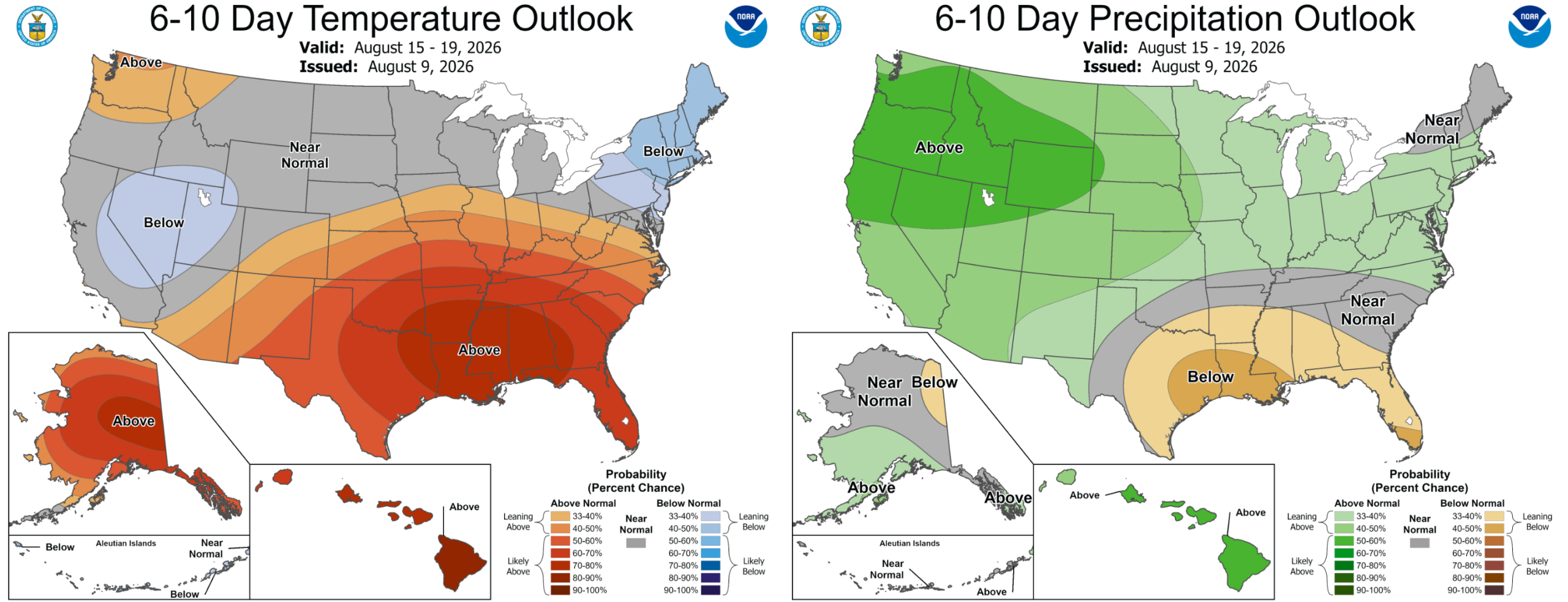
Even better, the cooler, wetter weather is favored to stick around for more than a day or two this time, with the extended ensemble guidance not really including any 90s for the Denver area next week either.
Furthermore, the Climate Prediction Center highlights increased odds for wet weather next week as well. Good news all around!
Bottom Line
The Front Range will stay locked in a hot, stagnant pattern through Tuesday with mid to upper 90s, limited storm coverage, and continued smoke/ozone concerns. A sharp shift will arrive midweek as the ridge breaks down and monsoonal moisture surges back into Colorado, driving cooler temps, widespread storms, and a legitimate heavy‑rain potential Thursday and Friday. The flash flood risk will need close monitoring, but at least we’re finally seeing a setup that favors a return to beneficial, soaking rainfall for much of the Boulder–Denver corridor! Cooler, wetter weather looks to stick around for at least a week.
DISCLAIMER: This weekly outlook forecast is created Monday morning and covers the entire upcoming week. Accuracy will decrease as the week progresses as this post is NOT updated. To receive daily updated forecasts from our team, among many other perks, subscribe to BoulderCAST Premium.
Go Premium, get all the perks.
Daily Forecast Updates
Get our daily forecast discussion every morning delivered to your inbox.
All Our Model Data
Access to all our Colorado-centric high-resolution weather model graphics. Seriously — every one!
Ski & Hiking Forecasts
6-day forecasts for all the Colorado ski resorts, plus more than 120 hiking trails, including every 14er.
Smoke Forecasts
Wildfire smoke concentration predictions up to 72 hours into the future.
Exclusive Content
Weekend outlooks every Thursday, bonus storm updates, historical data and much more!
No Advertisements
Enjoy ad-free viewing on the entire site.
Enjoy our content? Give it a share!












You must be logged in to post a comment.