We’ve got a few more mild days ahead to end the work week, but as promised, winter will return for the holiday weekend in what is shaping up to be a challenging forecast indeed. We are finally starting to see better agreement in the various weather models, but things are still far from certain. Our weather will begin to trend downhill on Saturday with cooler temperatures and a chance of rain showers. Saturday night rain will change to snow with snow accumulation likely for all heading into Christmas Eve. Exact snowfall amounts and the timing of everything are still being worked out, but here’s our latest thoughts on the approaching holiday winter storm.
Author: BoulderCAST Team (Page 14 of 48)
This post had major contributions from at least two members of our team. The more meteorologists the better, right?


November 2023 was yet another warm and dry month in Boulder with just one medium-sized snowfall event to speak of —- that occurred the day after Thanksgiving. Despite the relatively parched last few months, officially drought has not yet returned to the Front Range. Here’s a quick and colorful graphical recap of our weather during November and how it relates to climatology.
A dangerous downslope windstorm is about to unfold in the Foothills to the west on Thursday with gusts up to 90 MPH. It will be warm and gusty across the lower elevations as well, with a chance for very strong gusts in the usual windy spots like Boulder. A trough will move into the area on Friday turning our temperatures much colder with several chances for light snow. Read on as we discuss those powerful winds and the incoming snowfall.
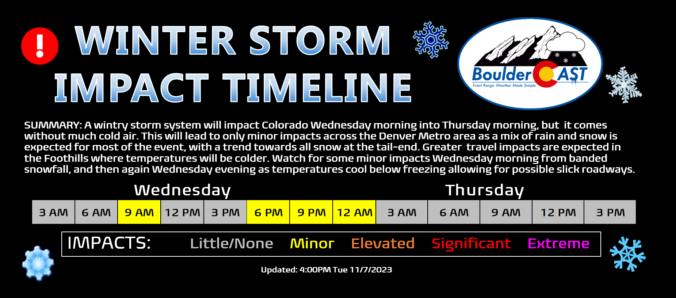
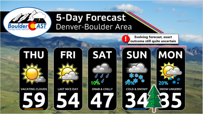
A wintry storm system will impact Colorado Wednesday morning into Thursday morning, but it’s not bringing much cold air to the party! This will lead to only minor impacts across the Denver Metro area as a mix of rain and snow is expected for most of the event, with a trend towards all snow at the tail-end as precipitation will be wrapping up. Greater travel impacts are expected in the Foothills where temperatures will be colder and up to 8 inches of snow may accumulate. We discuss the timing of the rain and snow, the expected snowfall totals for everyone and when travel may be most impacted.
October 2023 was an overall warm and very dry month in Boulder, but the days leading up to Halloween turned markedly colder with our first snowfall of the season arriving just a tad later than usual, and it was a sizable one for many! Despite the dry last few months, officially drought has not yet returned to the Front Range. Here’s a quick and colorful graphical recap of our weather during October and how it relates to climatology.

Live View of Boulder

Current Conditions

Live Radar

Recent Premium Posts

BoulderCAST Daily – Wed 06/24/26 | Another Day of Severe Weather
🌩️ Severe setup once again today with the threat of very large hail …
BoulderCAST Daily – Tue 06/23/26 | High‑End Hail Threat Targets the Denver Area, with the Risk Lingering into the Overnight
🌩️ Severe setup persists with upslope + strong westerlies aloft + copious moisture/instability …
BoulderCAST Daily – Sun 06/21/26 | First Notable Smoke Plume Arrives for the First Day of Summer
🌫️ Smoky skies return: A large wildfire in Utah has smoke surging into …
3-Day Forecast

Trending Content

© 2026 Front Range Weather, LLC