Winter weather is on-track to arrive into the Front Range Saturday evening into Sunday just in time to give most of us a white Christmas! Two vastly different storm systems will be moving in from opposite directions later in the day Saturday with widespread rain changing to snow across the Boulder and Denver area. While we still have some lingering concerns regarding temperatures and exactly when rain will switch-over to snow, our forecast confidence has grown over the last few days. In this final forecast update, we discuss the storm’s timeline, how much snow will accumulate across the area, the probability the snow sticks around into Christmas Day, and how it will impact holiday travel the next few days. We’ve even got another chance of snow coming the day after Christmas. Whew! Read on for all the details.
Our final forecast: Snow just in time for the holidays!
We’ve been tracking this holiday special edition of winter weather all week and hopefully you’ve been following along with us and are thus already caught up to the general details. The forecast has remained very difficult all along due the uncertainty of how two separate storm systems would phase together over our region — one warmer storm coming up from Mexico and another colder storm dipping in from western Canada. Initially there were a few outlier model runs showing that these storms could merge perfectly for Colorado, producing big upslope snow in our neck of the woods (a foot or more). However, these model solutions were always considered outliers and were never the expected outcome, though it has definitely been an interesting week for us weather people tracking this evolving storm!
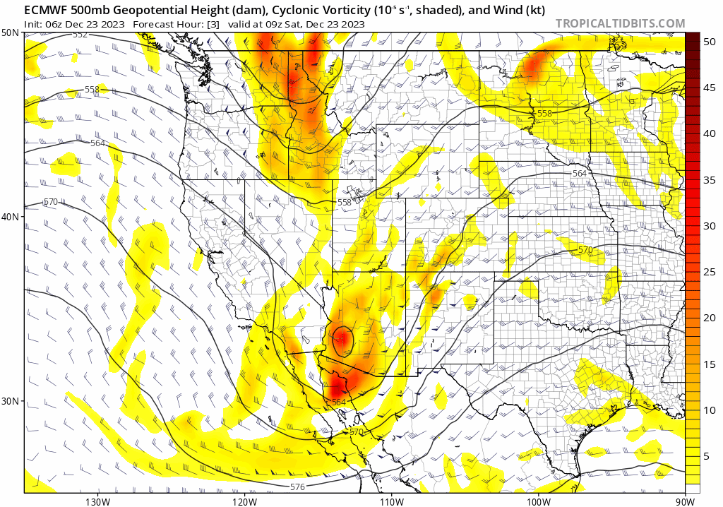
With things now knocking on the door at the time of writing Saturday morning, we finally have a rather clear solution for how things will transpire — and whether you like it or not — the final product unsurprisingly isn’t one that will favor the Front Range for significant snow. Almost all models now show very minor phasing between the two storms, with the southern system’s energy passing through our area Saturday and then getting swept into the Upper Midwest. The primary storm for us this weekend will instead be the colder one coming out of Canada which grows into a massive cut-off low by Christmas Day to the east in South Dakota and Nebraska. This will lead to a less-than-ideal amount of lift across the area, but nonetheless everyone should be waking up to at least some accumulating snow by Sunday morning. The pseudo-phasing of the two storms in the middle atmosphere is shown in the below animation running from Saturday through Tuesday morning, compliments of the Euro model:
While most of the Denver Metro area is still expected to see low-end snow totals that we’ve been touting all along, recent model runs have become more favorable for higher snowfall amounts in the Foothills. The greatest forecasting challenge now lies in determining the change-over timing from rain to snow across the lower elevations (yes, it will initially be too warm for frozen precipitation), as that same snowy Foothills signal could ultimately translate over into the adjacent Plains as well, including the city of Boulder, should temperatures cooperate.
The problem with this weekend’s storm, now nerfed by the lack of a good track and minimal phasing, is that upslope will be fairly brief across our area, with the deepest and most favorable upslope only lasting about 8 to 12 hours from late Saturday afternoon into early Sunday morning. At times, especially early Saturday evening, upslope will be very favorable out of the east-northeast direction. This upslope will also coincide with the best synoptic lift from the more southern of the two low pressures, as well as some instability, so things could really get rocking across our area Saturday evening as all the ingredients come together in earnest.
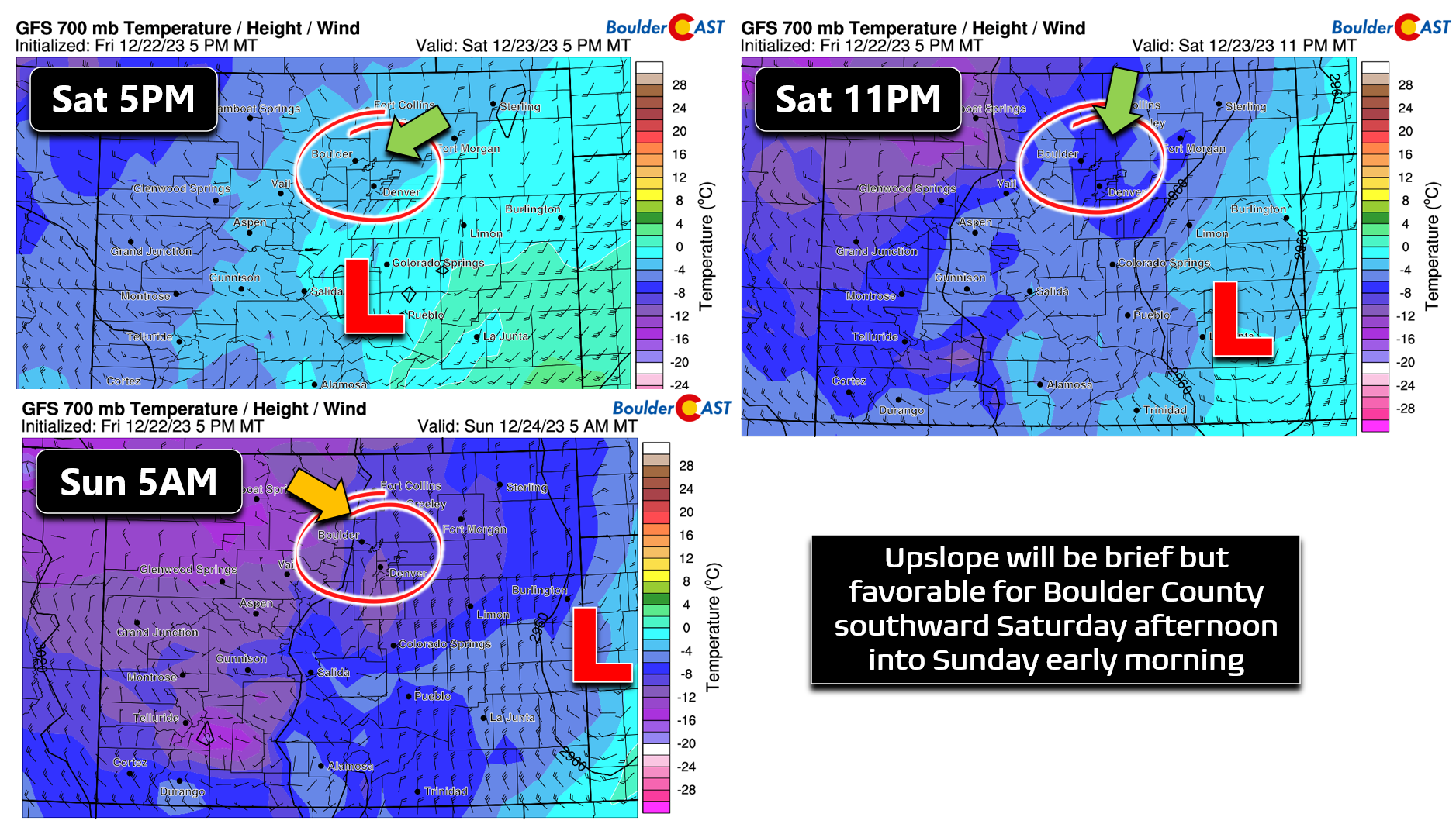
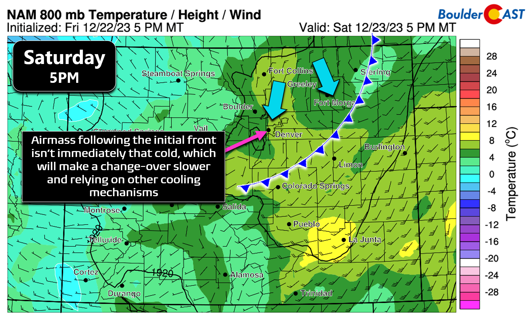
The one lacking ingredient, and arguably the most important for snow of course, is cold air. A decent cold front will drop south across the Front Range Saturday afternoon, but the air behind the front isn’t particularly cold. After another mild day in the 50s by early afternoon, temperatures will slowly drop through the 40s and into the 30s behind the front — not ideal for accumulating snow initially. Tonight’s snow will need to rely on additional cooling mechanisms in the atmosphere — mainly dynamic cooling from the upslope/lift but also phase-change cooling from melting snowflakes (aloft) and evaporating rain drops near the ground. It’s not uncommon for our snow events to rely on these mechanisms as well — not every storm is an Arctic blast after all (bonus points if you remember the ridiculous Arctic blast we had just before Christmas last year) — but relying on them so heavily in late December is not typical and certainly not ideal.
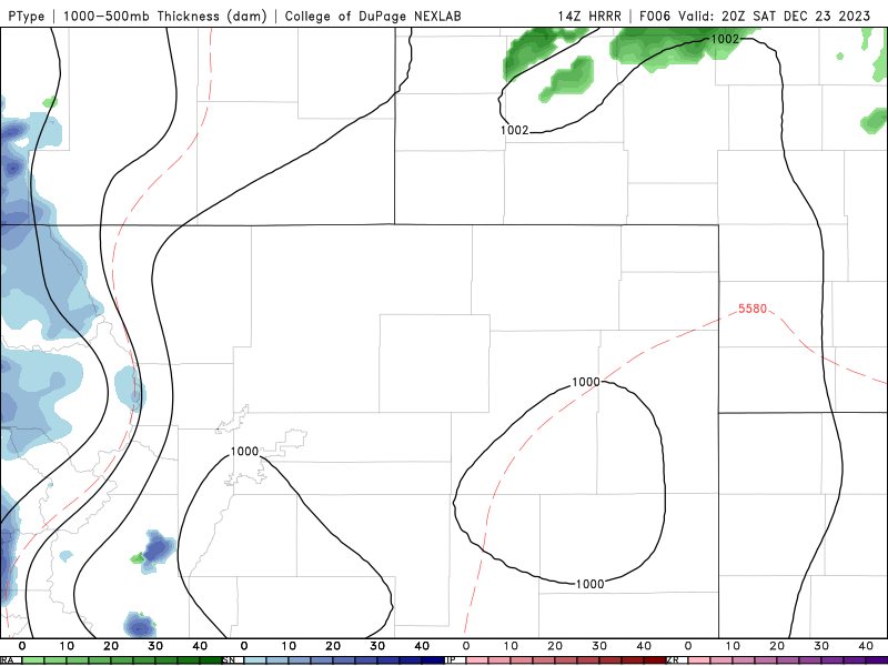
With this situation at hand, we do have some concerns about the change-over timing Saturday evening. Most model guidance suggests the shift from rain to snow will happen between 7PM and Midnight — the earlier the better for higher snowfall totals as that is the exact period when the best forcings will be coming together and the greatest potential exists for moderate to heavy snowfall rates. Typically the change-over occurs earlier than models would suggest, but not always. We expect most areas will make the transition sometime between 7PM and 10PM. Regardless of when the switch occurs, there will be plenty of melting early on owing to nine (yes nine!) straight days of above normal temperatures preceding this particular snow event. The HRRR model-simulated radar and type forecast animation is shown below. This usually reliable short-range model is showing several hours of rain in the Metro area before the change-over but with everyone turning to snow before midnight. Again the transitional timing is likely to be earlier, but this is some cause for concern.
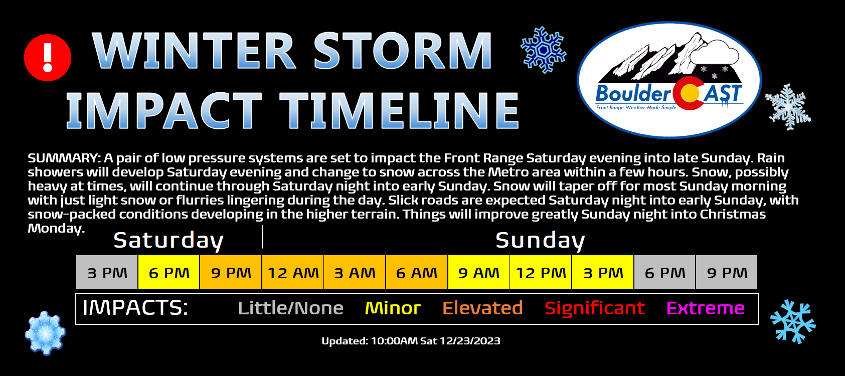
All things considered, here is how we expect things to play out this weekend heading into Christmas Day:
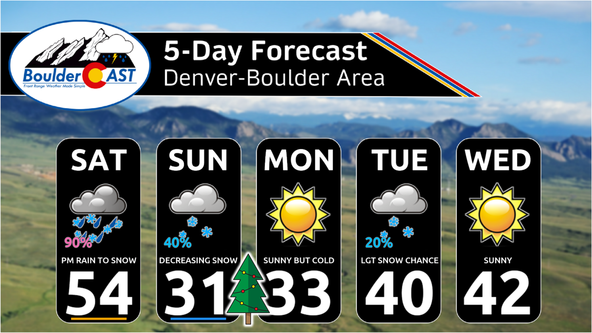
- Only last mild day on Saturday reaching the 50s by early afternoon with a mix of clouds and sunshine — enjoy it!
- A cold front moves through Saturday afternoon with temperatures tumbling and clouds filling in. There could be a few spotty rain showers during the afternoon, but most areas stay dry until the main event this evening,
- Temperatures will continue to cool and as upslope/lift intensity this evening, widespread precipitation will break out across the Front Range. It will initially be rain below 6500 feet elevation (the entire Denver Metro), but as temperatures cool everyone will change-over to snow before 11PM (some northern areas near Greeley or Fort Collins may linger as rain). Snow could be moderate to heavy at times, especially in and near the Foothills causing deteriorating travel conditions Saturday night.
- Snow will decrease in coverage and intensity later in the night, mostly wrapping up by sunrise on Sunday, though some light snow may be lingering in the western and southern Metro area as shallow upslope flow persists. Very minimal accumulation is expected after 8AM Sunday despite potential flurries or light snow continuing through the day.
- Travel conditions will deteriorate somewhat Saturday night into early Sunday with slick roads expected, with more dangerous snow-packed roads in the Foothills and Mountains.
- Roadways will improve during the day Sunday as temperatures warm into the low to middle 30s
- Christmas Day on Monday will be chilly but sunny with travel conditions not a problem at all.
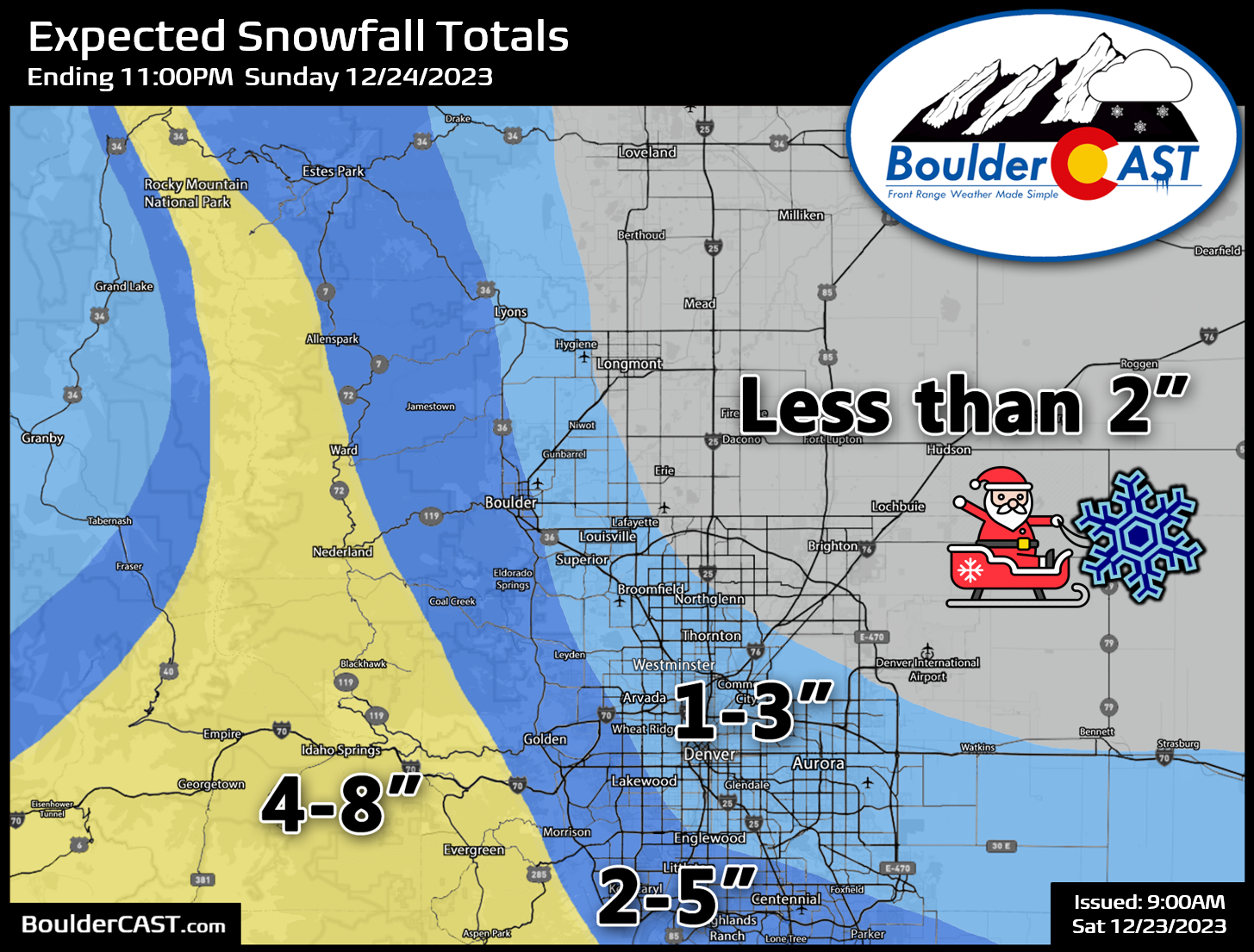
Our snowfall forecast map for this special holiday snow event is shown below. The Foothills will be cold enough for snow throughout the entire duration, leading the greatest predicted totals up there. They will also benefit from the best upslope and highest snowfall ratios (fluffier snow). Thus, we’re looking at 2-8″ of snow up there, highest in the southern tier from Boulder County southward. There could be a few localized areas getting close to a foot, most likely in the southern Foothills of Jefferson County. Across the lower elevations, it will be more of a mix bag with some snow being lost to rain and melting early on. However, eventually everyone will change to snow and pick up some accumulation Saturday night into early Sunday. We expect most areas on the lower elevations will see a dusting to 4″, but western and southern suburbs will see slightly greater amounts due to their higher elevation and better upslope forcing. This is the type of storm where eastern parts of Boulder may see just 1-2″ where the area west of Broadway may see more like 3-5″. We expect less than 2″ for Longmont, Greeley and Fort Collins, perhaps even close to zilch.
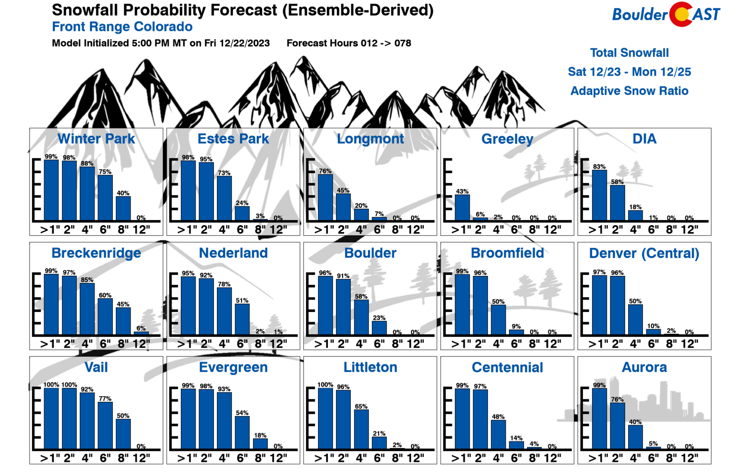
Just to shed light on the potential uncertainty, let’s also take a look at the latest Snowfall Probabilities. These percentages may be skewed just a tad high due to the rain/snow change-over moisture (6PM to Midnight Saturday PM) getting counted as all snow (that’s how the models work), but nonetheless they do show the spread. Both Boulder and Denver are looking at good chances for at least 2″ of snow, though odds drop off rapidly heading above 4″. Experience tells us that this storm has a better chance to bust (come in low) rather than boom (blow past the forecast), but we shall see!
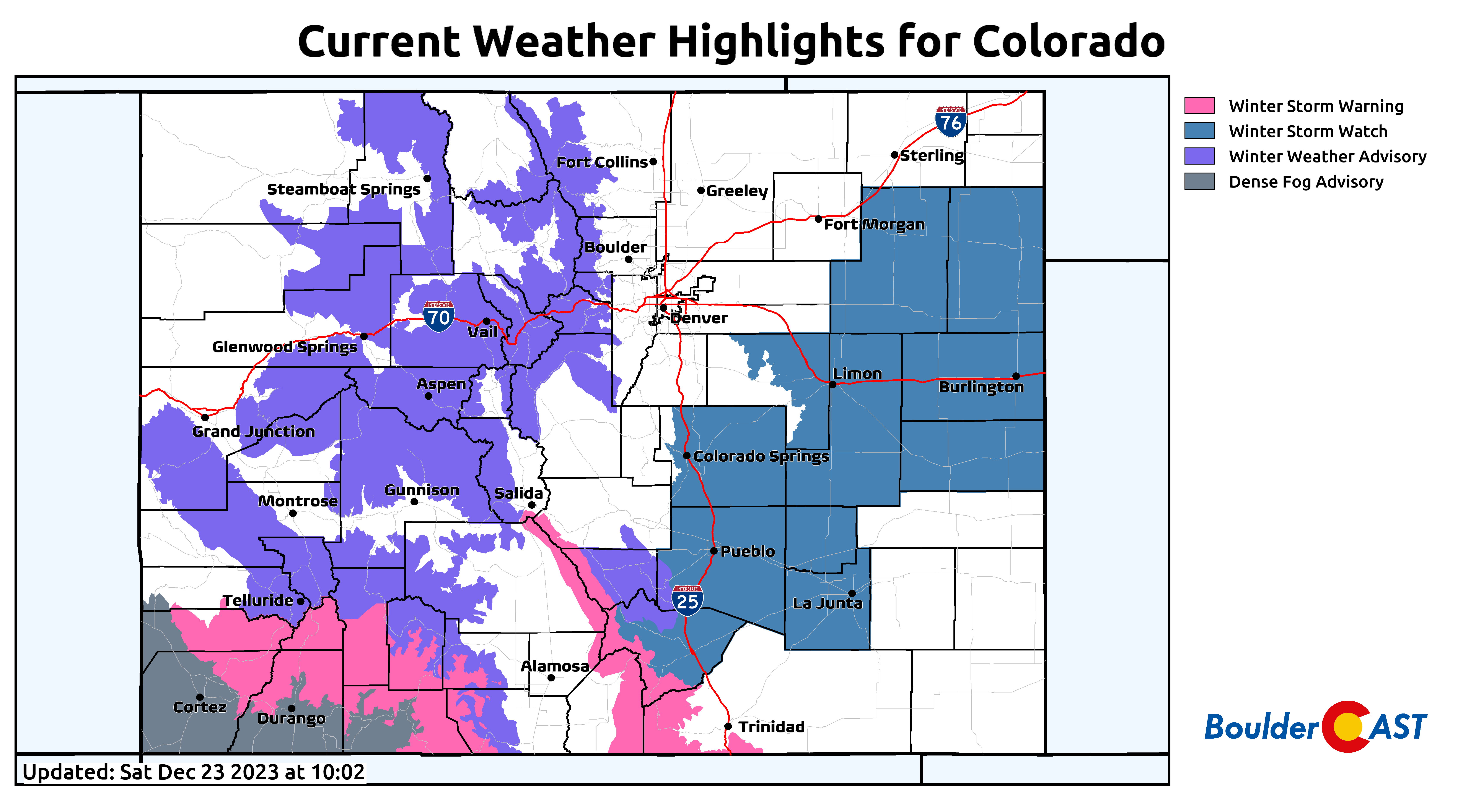
Currently there are no snow-related highlights in the Metro area or Foothills (though the Mountains and eastern Plains are blanketed), but this could change. Some Winter Weather Advisories may be posted at some point today, mainly in the Foothills, but also possibly for some of the western Denver Metro area for snow coinciding with the busy holiday travel this weekend.
Will we have a true “White Christmas” this year?
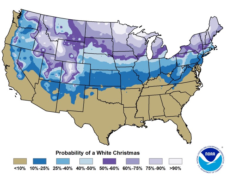
The official definition of a white Christmas, according to the National Climatic Data Center (NCDC), is 1″ or more of snow on the ground for Christmas Day. This handy map shows the Denver Metro area has about a 40-50% chance of that criteria being met.
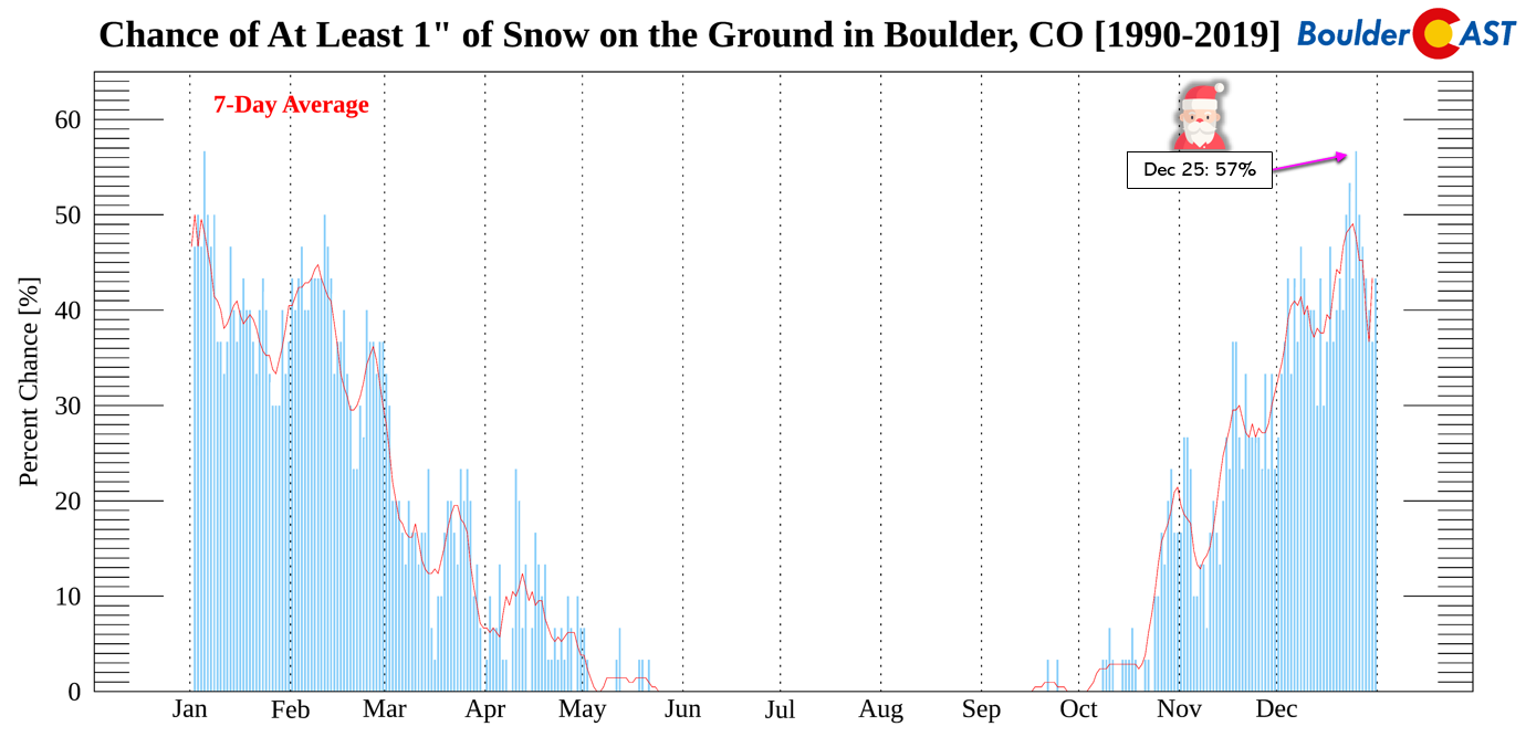
A closer look at Boulder shows Christmas as having a 57% chance based on the last 30 years of data, tied for the highest percentage out of any day in the year! If you are interested, we talked in another post previously about why Christmas-time has the best chance of snow on the ground.
Because the departing massive low pressure stalls out and meanders over the Great Plains into the middle part of next week, the cold air will remain locked in over the Front Range for a few days. Temperatures will remain near or below freezing all the way into Tuesday morning for us. This should help keep whatever snow falls this weekend on the ground into Monday. Most areas stand a good chance of having a (predominantly) white-covered ground Monday morning. However, the eastern/northern parts of the Metro area that see lesser snow amounts may have some troubles. Things appear to warm up back towards normal by Tuesday and Wednesday, though there is some sign that the big low pressure in the Midwest will wobble back westward bringing a return of upslope and light snow for us on Tuesday. We don’t foresee much if any accumulation from that, though.
Be sure to follow us on Twitter, Facebook, and (finally now) on Threads for more timely updates as this rain and snow event unfold. However, considering it is a holiday after all and most of our team is traveling, our commentary may be less frequent than usual this weekend.
Finally, if you want to help support the wonderful work we do here at BoulderCAST and/or wish to receive a morning weather update from us every single day for the next year, consider subsubscring to BoulderCAST Premium; our 2023 holiday sale is ongoing.

We appreciate you stopping by and enjoy the snow!
From all of us at BoulderCAST,
we wish you a Happy Holidays!

Go Premium, get all the perks.
Daily Forecast Updates
Get our daily forecast discussion every morning delivered to your inbox.
All Our Model Data
Access to all our Colorado-centric high-resolution weather model graphics. Seriously — every one!
Ski & Hiking Forecasts
6-day forecasts for all the Colorado ski resorts, plus more than 120 hiking trails, including every 14er.
Smoke Forecasts
Wildfire smoke concentration predictions up to 72 hours into the future.
Exclusive Content
Weekend outlooks every Thursday, bonus storm updates, historical data and much more!
No Advertisements
Enjoy ad-free viewing on the entire site.
Enjoy our content? Help us out and give it a share:


You must be logged in to post a comment.