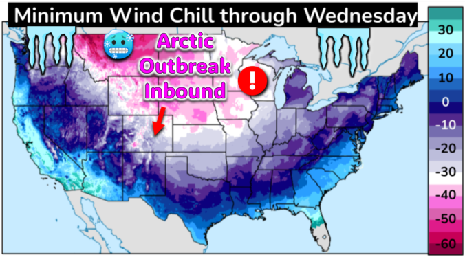
The most significant Arctic outbreak for the Front Range since 2022 is brewing! The initial cold front will blast through Friday early evening ushering in sub-zero wind chills which will persist all the way into at least Tuesday morning. While the extreme cold is all but certain at this point, the snowfall potential is a bit trickier of a forecast as there will be three separate chances for snow mixed into the polar plunge. However, the Mountains will be getting absolutely showered in powder. Let’s take a look at bitter cold and snowy forecast heading into the MLK holiday weekend.
At a Glance
- Dangerous cold will unfold in the Denver area following an Arctic cold front around sunset Friday evening — and the extreme cold will linger for at least four days
- A period of snow is expected to follow the arrival of the cold Friday night with up to 4 inches of fluff in spots thanks to embedded heavy snow bands
- Temperatures will fluctuate mainly between -13°F and +7°F for three to four straight days, wind chills remain almost entirely below zero during this time
- Two other periods of light snow are in the cards across the Denver Metro area as well, but neither of them look very impressive — the biggest concern from this outbreak is definitely the cold
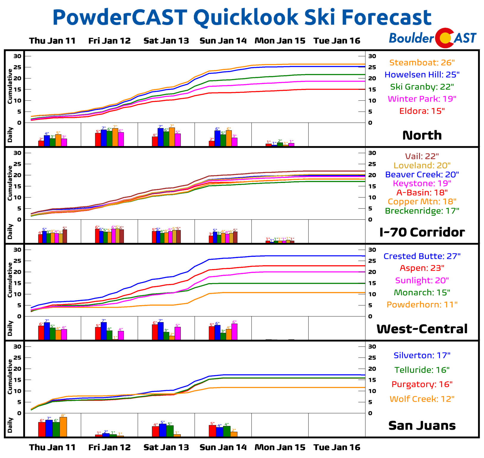
- Intermittent waves of moderate to heavy snow will be impacting the Mountains during this time with 1 to 3 feet of total accumulation expected — travel will be treacherous in the High Country and Foothills all weekend into early next week
- The coldest temperatures of the entire outbreak MAY be Monday night when temperatures may drop as low as -20°F in the Metro area
- Things will begin to warm up again rapidly around the middle of next week, but that’s a long ways out!
Brace for a prolonged period of dangerous cold!
We first brought attention to the looming Arctic outbreak more than a week ago when we noticed very convincing ensemble support for sub-zero temperatures in Denver (for this weekend). We’ve continued to track the movement of this polar airmass ever since. It’s now a certainty that this bone-chilling air will make its assault on the Front Range Friday evening and stick around for the entirety of the holiday weekend ahead. What amazing timing Mother Nature has, right?
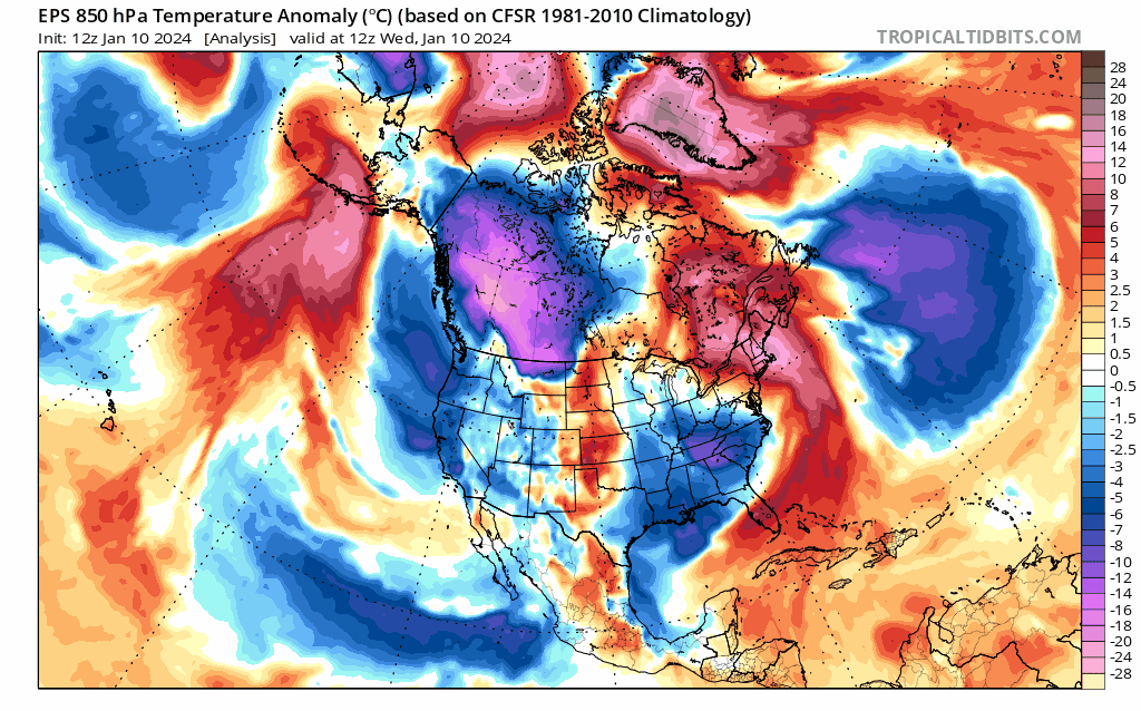
The cold air that is headed our way Friday night has been “stewing” for a while up in far northwestern Canada in the Arctic Circle, an area that sees nearly 24 hours of darkness this time of year. The forecast animation below shows the extremely cold airmass blasting its way southward into the United States, including through the entirety of eastern Colorado. Eventually this Arctic air will make it all the way down into Central America by the middle of next week (in a moderated, way less cold form) — a rare occurrence that speaks to the magnitude of this looming Arctic outbreak!
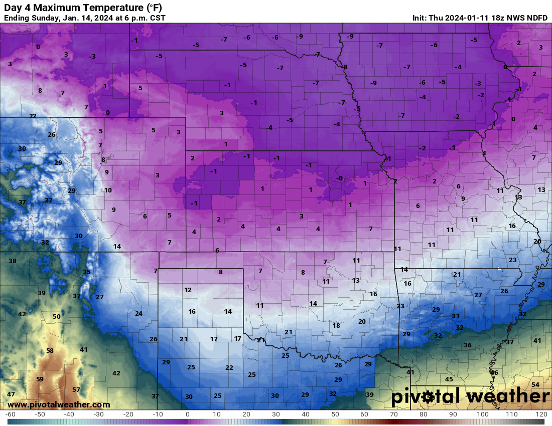
One key aspect of this Arctic blast is that initially the airmass will be too shallow to make it up and over the Continental Divide, at least until a few days down the road. This forecast high temperature map for Sunday demonstrates the limited reach of the Arctic airmass. Temperatures will be stuck in the single digits for Boulder and Denver, but in the 20s and 30s for places like Granby, Steamboat and Alamosa on the other side of Colorado’s tallest peaks. Grand Junction may even be in the 40s!
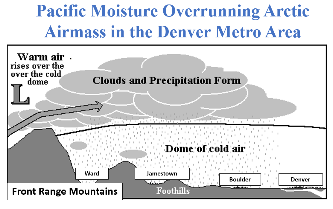
This will create a scenario where the Mountains remain largely under the gun from moist west and northwest flow all weekend long, with some overflow and even enhancement into the Foothills due to the “warm” moist air riding up and over the dense Arctic airmass to the east of the Mountains. This is called overrunning and it will play some role in how much snow we see from this winter blast, particularly in the Foothills communities. More on that in a moment…
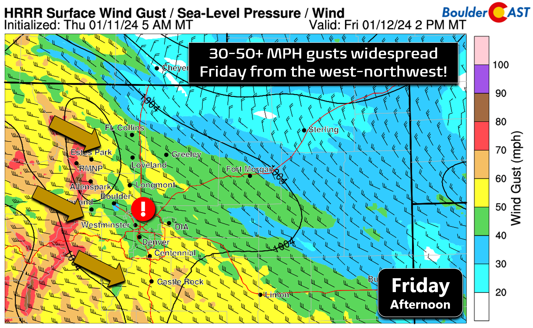
Before things go downhill, our temperatures will top out in the 30s on Friday with gusty downslope winds. That’s all we get for the “warm before the storm” this time around. Considering what will transpire in the days to follow, 30s is definitely warm, relatively speaking! Winds will be gusting 30 to 50 MPH again, similar to what we endured earlier this week on Wednesday.
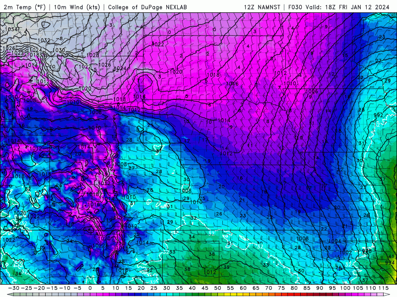
For the Denver Metro area, the Arctic front will arrive like a freight train Friday evening, sometime around sunset, replacing intense downslope winds with bitter cold air from the northeast. The forecast animation below shows the extremely strong pressure and temperature gradients along the boundary — a sure-fire signature of an Arctic front. Temperatures are expected to drop into the single digits rapidly behind the front and within several hours, we will be below zero — a first for most Front Range cities this winter. Temperatures by sunrise Saturday may be close to -10°F!
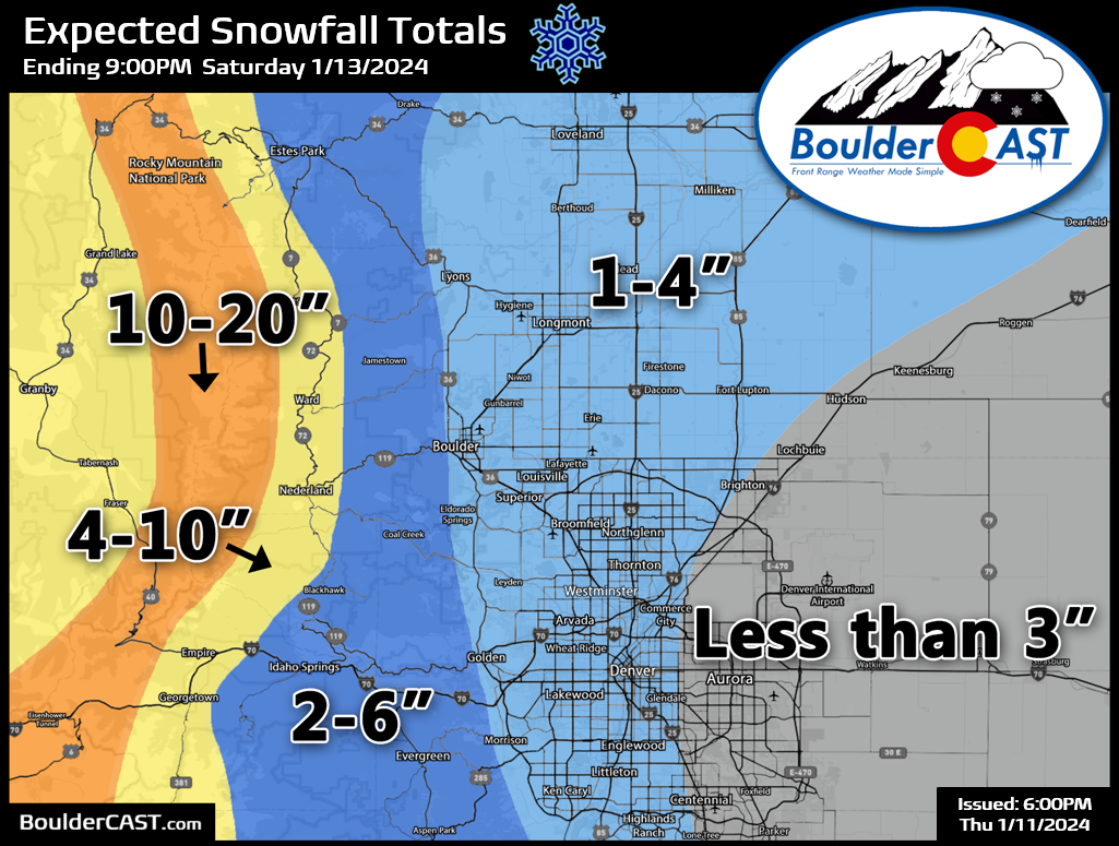
The first chance of appreciable snowfall will be in the hours following the front as things saturate, upslope ensues, and some jet and mid-level frontal forcing move through, mainly between 8PM Friday and 6AM Saturday. There could be a few embedded heavy bands of snow mixed in due to the jet, but for the most part snow will be spotty and light. However, it will be very fluffy snow, so anywhere that sees a band or two could pile up a quick 3 to 4″. That will be the exception more so than the rule Friday night. Our snowfall forecast map for this first post-frontal wave of snow is shown below. This covers all snow through Saturday evening. Any snow that falls will have no trouble sticking/blowing around on roadways making for some slick travel late Friday night into Saturday morning.
Temperatures on Saturday will warm very little across Boulder and Denver as cold air continues to funnel in from Wyoming and Nebraska. High temperatures will be in the single digits across the lower elevations. Wind chills will stay below zero all day. The Arctic air will be fully entrenched!
Saturday night temperatures drop well below zero with wind chills below -20°F at times.
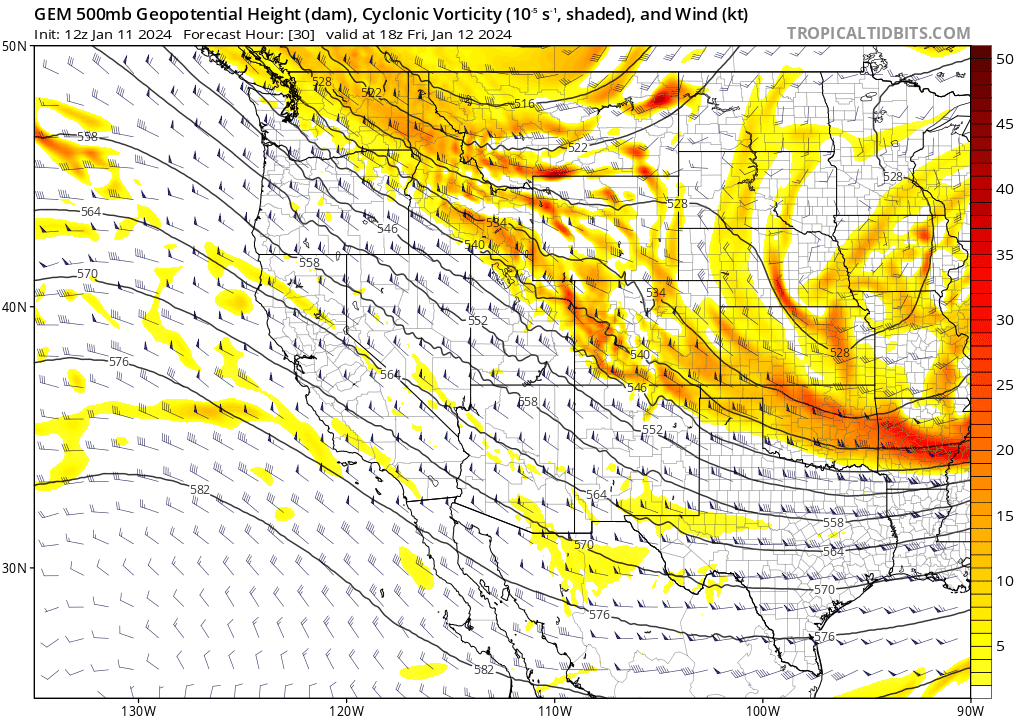
Sunday will be almost identical to Saturday with another chance of light snow during the day, but most of it will be confined to the Mountains. The forcing for Sunday’s snow is via a petite shortwave disturbance racing in from the Pacific, through Oregon and across southern Colorado. This will turn up the dial on the aforementioned overrunning setup, with heavy snow in the Mountains and some of that spilling over into the Foothills and perhaps even some into the adjacent Plains. The second round of snow on Sunday likely produces another dusting to 2″ west of Interstate 25, and not much to the east of there. 3-6″ could fall in the higher Foothills. Temperatures will once again only make it into the single digits for highs, but we should be a tad warmer than Saturday.
Sunday night we’ll be back well below zero again with dangerous wind chills below -20°F in spots.
The forecast for Monday remains somewhat uncertain. Models have started to now advertise a piece of energy rotating in from the north out of Canada. This would bring with it one final reinforcing shot of, if you can believe it,even colder Arctic air — as well as another chance of snow along a cold front. Depending on the timing of this feature, Monday could be the coldest day of them all with temperatures struggling to get above zero in Boulder and Denver during the day, or it could be in the lower teens for highs. We expect continued Mountains snow into Monday, but the snow chance east of the Mountains and in the Metro area remains more nebulous. That is essentially five days out from right now, so we will revisit Monday’s snow chance and potentially even colder temperatures in due time. Any snow chance is expected to be fairly light again, though.
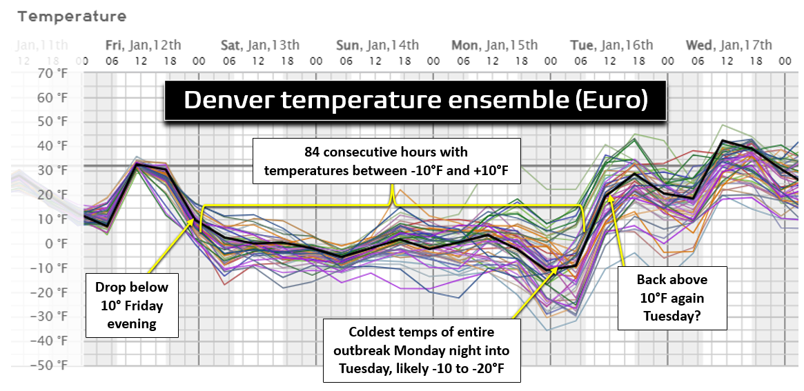
When all said and done, the Denver area will spend approximately 84 hours below 10°F due to this Arctic outbreak — all the way from Friday evening until Tuesday morning (see the handy timeline graphic below). Typically the coldest temperatures from Arctic outbreaks come at the tail-end of things when clouds begin to clear but the bone-chilling airmass is still locked in. That looks to happen Monday night into Tuesday with this particular outbreak, though that is still uncertain. This ensemble spread below has a mean around -10°F in Denver Monday night, but ~20% of members are below -20°F, and even one huge outlier as cold as -36°F!
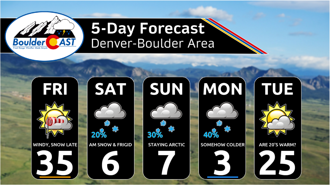
Here’s a look at the next five days in the Metro area. Yikes! The light at the end of the tunnel for now appears to be Tuesday when we warm up nicely into the 20s! Might have to dust off our t-shirts for the occasion!
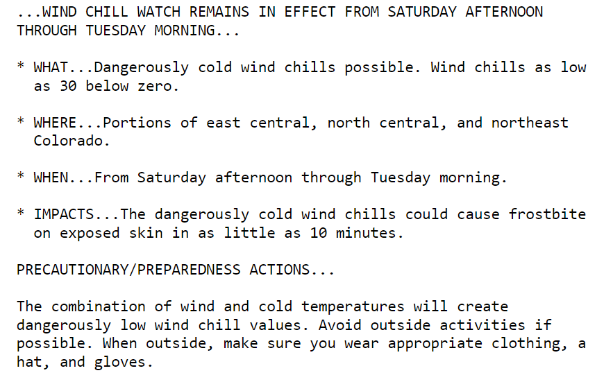
In all seriousness, though, you should absolutely plan to spend a minimal amount of time outside this holiday weekend. You don’t want to be caught in a life-threatening situation. A Wind Chill Watch is currently in effect for Saturday through Tuesday!
There is also a Winter Storm Warning in effect for heavy snow combined with extreme winds in the Mountains all weekend long and into next week!
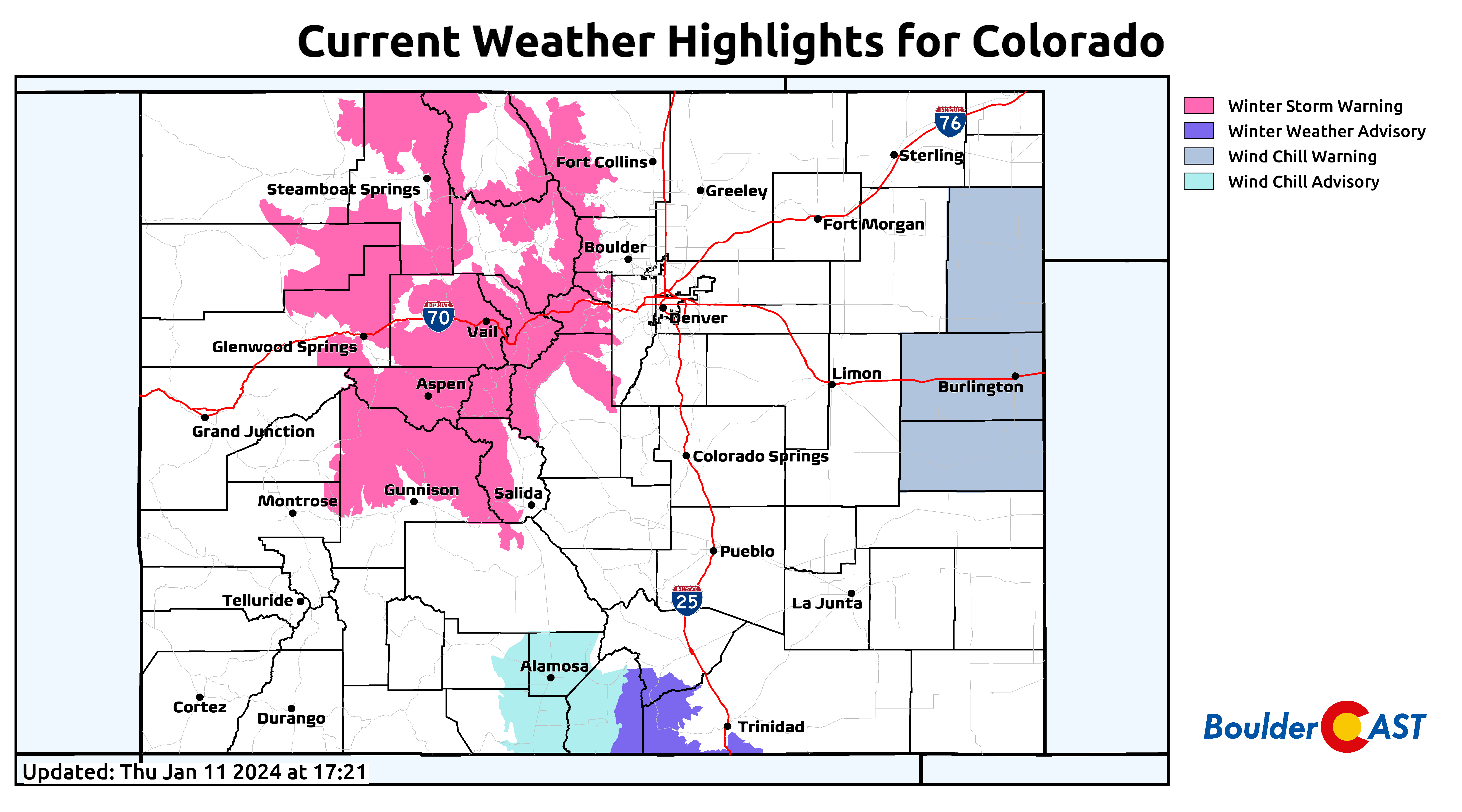
Yes, there will almost for sure be heaps of fresh powder in the Mountains, but getting there will be a nightmare. Expect major travel issues in the mountain passes for several days ahead.
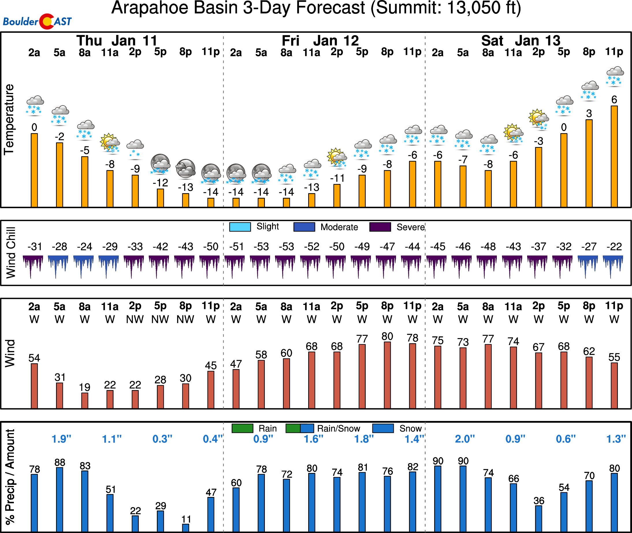
It’s not only snow you have to worry about. It will also be extremely cold and windy up there, with wind chills below -50°F at some of the ski resorts. For example, at the top of A-Basin on Friday when temperatures will be well below zero with winds above 50 MPH!
Finally, here are some grim but important tips for extreme cold weather situations. Surely you know most of these, as Front Range Colorado is no stranger to bitter cold, but we will leave them here anyways:
- Dress in layers of loose-fitting, lightweight, warm clothing, and wear a hat, mittens, and a scarf to cover your mouth and nose.
- Stay dry and avoid sweating, as wet clothing can lose its insulating value and make you more susceptible to hypothermia and frostbite.
- Limit your time outdoors and seek shelter if you feel cold, numb, or tired.
- Protect your pets, livestock, and plants from the cold by providing them with adequate shelter, food, water, and insulation
- Keep your car well-maintained and stocked with a winter survival kit that includes items such as jumper cables, flashlight, first aid kit, food, water, blanket, ice scraper, shovel, and cat litter or sand.
- Prevent your pipes from freezing by letting water slowly drip from faucets, opening cabinet doors, and keeping the heat on at a minimum of 55 degrees.
- Never use open flames, gas ovens, or generators indoors, as they can produce deadly carbon monoxide gas. Install a carbon monoxide detector and check the batteries regularly.
- If your pipes freeze, do not try to thaw them with a torch or a flame. Use a hair dryer instead and be careful of electric shock hazards.
- If you get stranded in your car, stay inside, run the engine for 10 minutes every hour, and make sure the exhaust pipe is clear of snow.
This is shaping up to be our most significant Arctic outbreak since the record-setting one back in December 2022. If interested, check out our lengthy recap post of that recent outbreak here.
That’s all for now. Be sure to follow us on Twitter, Threads, or Facebook for real-time updates in the days ahead, or join us on BoulderCAST Premium for in-depth daily updates every morning. Stay warm!
ALL 50 states have significant weather highlights in effect right now for impending strong winds, flooding, avalanches, hard freezes, dust storms, blizzards, fires, big waves, snow, and/or dangerous wind chills. What a time to be alive as a meteorologist! #COWx #USAwx pic.twitter.com/rplBos8vOM
— BoulderCAST Weather (@BoulderCAST) January 11, 2024
Get BoulderCAST updates delivered to your inbox:

Go Premium, get all the perks.
Daily Forecast Updates
Get our daily forecast discussion every morning delivered to your inbox.
All Our Model Data
Access to all our Colorado-centric high-resolution weather model graphics. Seriously — every one!
Ski & Hiking Forecasts
6-day forecasts for all the Colorado ski resorts, plus more than 120 hiking trails, including every 14er.
Smoke Forecasts
Wildfire smoke concentration predictions up to 72 hours into the future.
Exclusive Content
Weekend outlooks every Thursday, bonus storm updates, historical data and much more!
No Advertisements
Enjoy ad-free viewing on the entire site.
Enjoy our content? Help us out and give it a share:


You must be logged in to post a comment.