It may seem odd to call 8 inches of snow in Boulder and 4 inches in Denver “disappointing”, but that is indeed our sentiment towards the prolonged winter storm that moved through over the weekend. All of the ingredients for snow came together in unison, including one of the coldest airmasses so far this winter and juicy moisture from an atmospheric river. We discuss why snow totals came in on the lighter side and the record-breaking cold air.
S
hown below is our snowfall forecast map with actual storm totals overlaid in boxes. Green boxes indicate that our forecast verified to within one inch of the observed snowfall. Red did not.

As you can see, our snowfall forecast turned out quite well for the the region as a whole. Lots of green boxes and only a few reds. Cities on the Plains did finish with low-end amounts, however. Given just how favorable conditions were for accumulating snow this weekend, we can’t help but feel a sense of disappointment. We did say that this storm had the potential to be the biggest this winter for some areas after all, even if that bar is embarrassingly low…
We had relatively high confidence in the forecast heading into Friday night, which did indeed play-out largely as expected over the weekend:
- The jet-forced snow Friday night just barely clipped Boulder (1″ of snow reported), but produced 2 to 6″ further north from Longmont to Fort Collins.
- As the primary Arctic front arrived and combined with jet-forcing and deeper moisture, widespread snow developed Saturday afternoon into the night-time hours across most of the Front Range. This surge was the “main event”, as expected, and most of Denver and Boulder’s snow fell during this period (about 3 to 6″).
- Light snow redeveloped as a final jet moved through during the day Sunday producing another dusting to 1″ for most areas.
So what went “wrong”? For the answer, we need not look any further than the snow laying on the ground! If you did any shoveling or snow angels over the weekend (guilty as charged!), you probably noticed how surprisingly heavy and wet the snow was. It was remarkably dense considering temperatures were in the teens and single digits when most of the snow was falling! Something was definitely astray….
Let’s take a look at snow ratios Saturday afternoon into Sunday morning (based on observations)….
- Boulder – 12:1
- Niwot – 11:1
- Broomfield – 12:1
- Longmont – 13:1
- Arvada – 10:1
- Denver – 11:1
- Aurora – 12:1
- Thornton – 13:1
- Golden 11:1
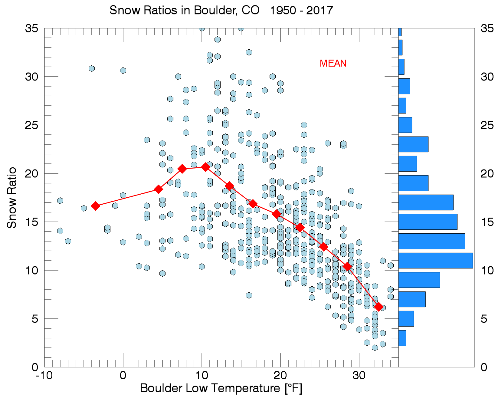
Whoa! Snow ratios THAT low are more common in late-March and April, and certainly are not typical for snow falling from an extremely cold Arctic airmass. Nearly 70 years of Boulder snow data shows ratios during sub-zero temperature snow events are typically around 15:1 (see graphic below). Another tidbit that can be gleaned from this chart: Saturday and Sunday were two of only 13 occasions in the last 70 years where snow occurred on the same day as sub-zero temperatures in Boulder! While there isn’t really such a thing as “too cold to snow”, without the injection of moisture aloft, typically Arctic airmasses this frigid are indeed too cold, and more importantly too DRY, to produce any measurable snow.
A closer inspection confirms that observed liquid precipitation amounts across the Metro area matched up with our expectations and the consensus of the models (about 0.35″ in Denver, 0.55″ in Boulder). Thus, the reason for the shortage of snow comes down primarily to the ratios being very low. This is something the models never really picked up on. Looking at the GFS (below on top), a very deep and saturated layer of the atmosphere was in the “sweet” spot of -12°C to -18°C for dendritic growth (light blue box). This is one of the main reasons our algorithms were showing 15 to 20:1 ratios for this event, and the reason for the upper bounds of our snow ranges. Big fluffy flakes sure do pile up quickly.

Forecast sounding from the GFS (top) vs. actual radiosonde data in Denver (bottom) for Saturday evening at 5:00PM during the height of the snowstorm
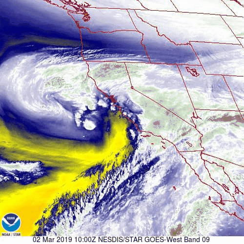
However, actual observational data (above on bottom) shows that temperatures overhead were too warm for dendrites to form during the height of the snow Saturday evening and night. In fact, there was an EXTREMELY warm and moist layer at about 12000 feet elevation Saturday evening. Hello, atmospheric river!
Following this weekend’s storm, seasonal snowfall totals for Boulder and Denver are only slightly below normal right now:
| Seasonal Snow Totals (Updated March 4 2019) |
|---|
| Boulder | Denver |
|---|---|
| 69.2" | 32.1" |
And of course with snowfall counted by the foot this weekend in the High Country, mountain snowpack is looking good right now….perhaps too good…

A remarkable cold airmass has overtaken our region, one that is nearly unprecedented for early March. Here are just a few of the chilling readings for Denver and Boulder this weekend:
- BOULDER:
- Morning low of -2°F on Sunday morning, not a record, but still darn cold!
- Morning low of -5°F on Monday morning, new daily record low for March 4th
- Daytime high on Sunday was in the single digits, possibly for the first time ever in March
- Official high on Sunday was 14°F (actually occurred Saturday evening), tied a record low high for March 3rd
- DENVER:
- Morning low of -6°F on Sunday morning, not a record, but still darn cold!
- Morning low of -5°F on Monday morning, new daily record low for March 4th
- Official high on Sunday was 6°F, new record low high (old was 14°F)
As a result of the Arctic air ushered in by a crazy 1055 millibar dome of high pressure in Montana (low-level cold air) and a moderately strong atmospheric river event (warm air aloft), a very deep inversion has developed across eastern Colorado.
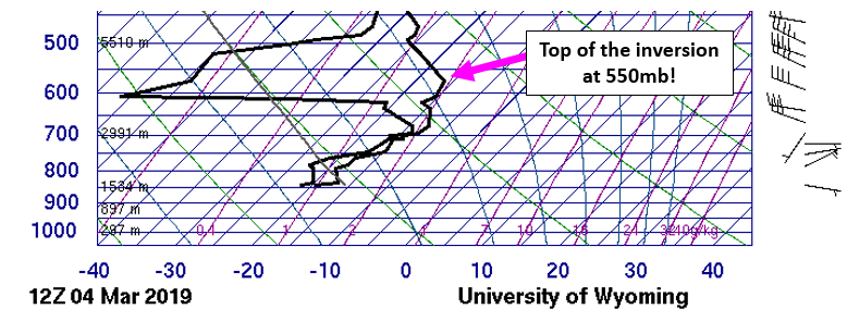
Atmospheric sounding from Denver Monday morning
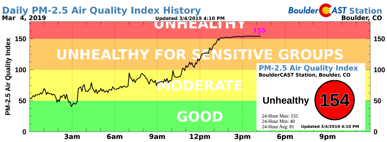
The top of this inversion this morning was well above the height of any of Colorado’s mountain peaks. This inversion has greatly limited mixing today and is tanking air quality across the Front Range. The PM 2.5 air quality index has been over 150 all afternoon in Boulder….
With high pressure expected to build Tuesday into Wednesday, we should see this deep inversion slowly mix out with improving air quality and moderating temperatures over the next several days. The next major storm system won’t arrive until late week. We’ll likely be dealing with smog until then. Check back tomorrow for our complete outlook with full details on our weather for the rest of the week!
Share these snow totals:


You must be logged in to post a comment.