Persistent westerly flow at the mid-levels of the atmosphere will allow the Front Range to warm up each day this week. This changes late Friday into Saturday when another cold front is set to push in from the northeast. We also discuss two minor chances of rain and snow during the week ahead.
The weather pattern in the mid-levels for the week is shown below for Tuesday through Friday. The most evident feature is a persistent west-southwesterly flow over Colorado. With the exception of Wednesday and Friday, most of our days should be sunny with weak ridging in place. During these “trouble” times, two storm systems will move through…a weak one on Wednesday and a stronger system Friday. This will lead to the chance of light rain and/or snow. However, given that the track of the storm systems is east-northeast, most of our area will be on the downslope end of things, keeping precipitation chances minimal for the Metro area.
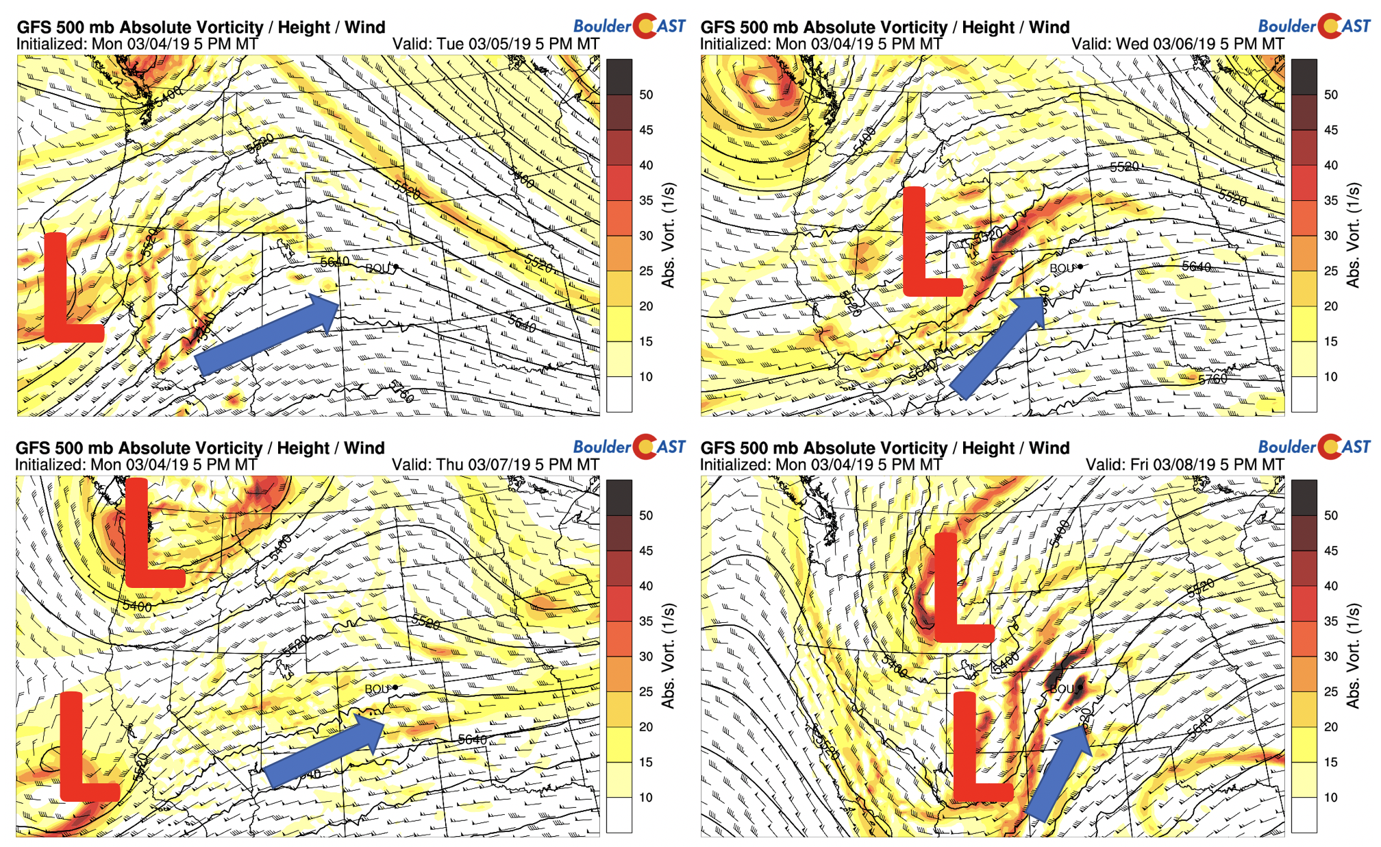
GFS 500 mb absolute vorticity for Today through Friday
The low-level temperature pattern accompanying the mid-levels is shown below. As expected, today through Thursday will be on the warmer side of things compared to this past weekend, as noted by the westerly flow (yellow arrows). However, the westerly flow is not as strong as the mid-levels, and there is a slight easterly component to the winds over the Plains. This will allow us to GRADUALLY warm each day as opposed to a significant warm-up. With fresh snow on the ground today, lower 30’s seem reasonable, followed by low to middle 40’s Wednesday and low to middle 50’s on Thursday/Friday. The pattern changes late Friday night and Saturday, with the passage of a strong cold front (bottom right) and trough of low pressure (above bottom right). Thanks to its downslope nature, it will likely be gusty and cold as we go into the weekend, dropping back into the 30’s to 40’s.
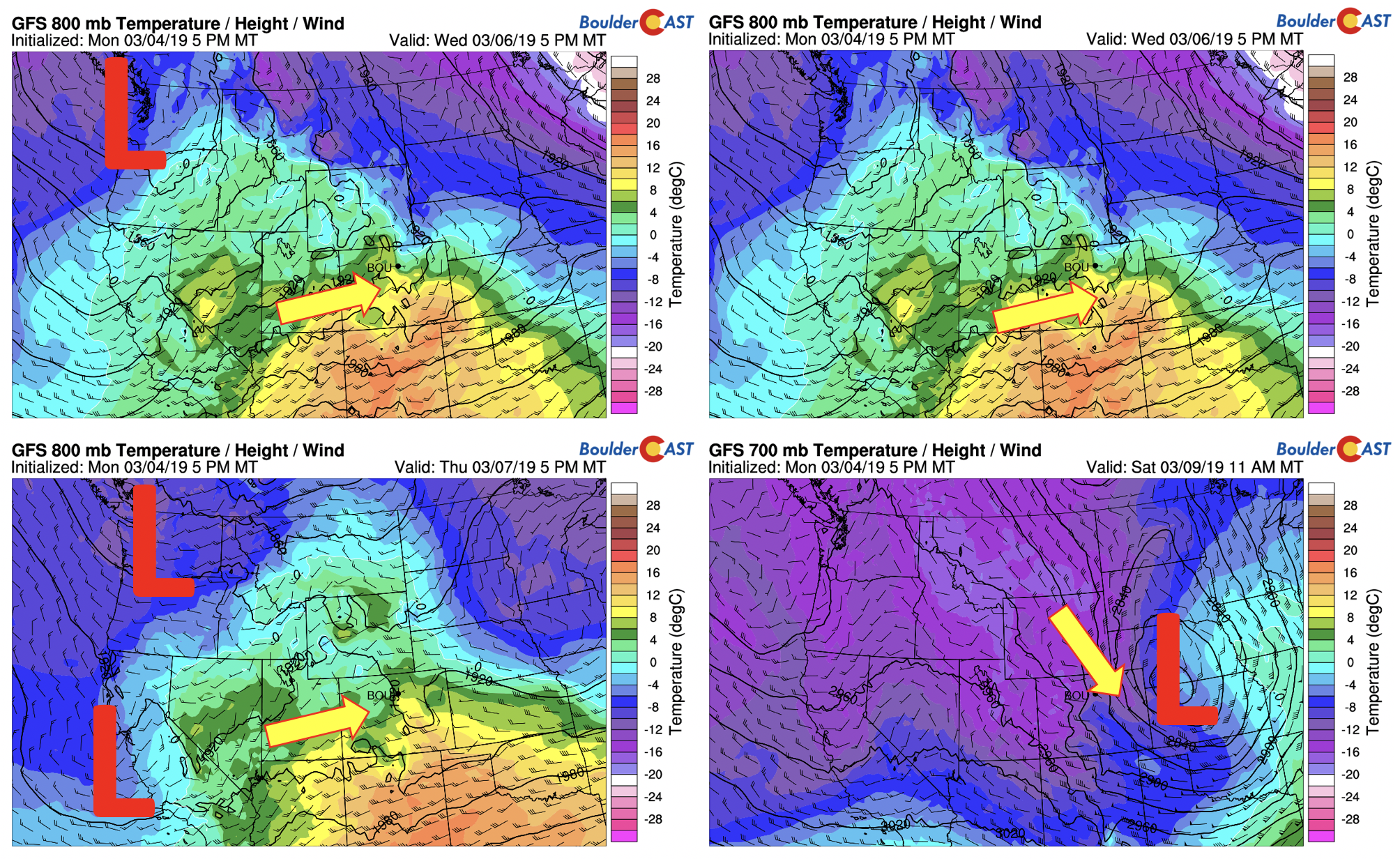
GFS 800 mb temperature for Today through Thursday, and 700 mb temperature on Saturday
As mentioned above, our precipitation chances will be minimal. This is evident below from the GFS ensembles for today through Saturday. The chance tomorrow night will be a mix of rain/snow but amounts will be very light, if any. The system will be tracking east-northeast and keeping Boulder in the downslope regime. The better chance exists late Friday into Saturday, though current trends in the models bring in a west-northwesterly wind across the area, preventing a decent upslope direction for much in the way of snow chances. However, given the dynamics and likely pattern changes between now and Saturday, we will put in a 20% chance for the weekend, followed by colder weather.
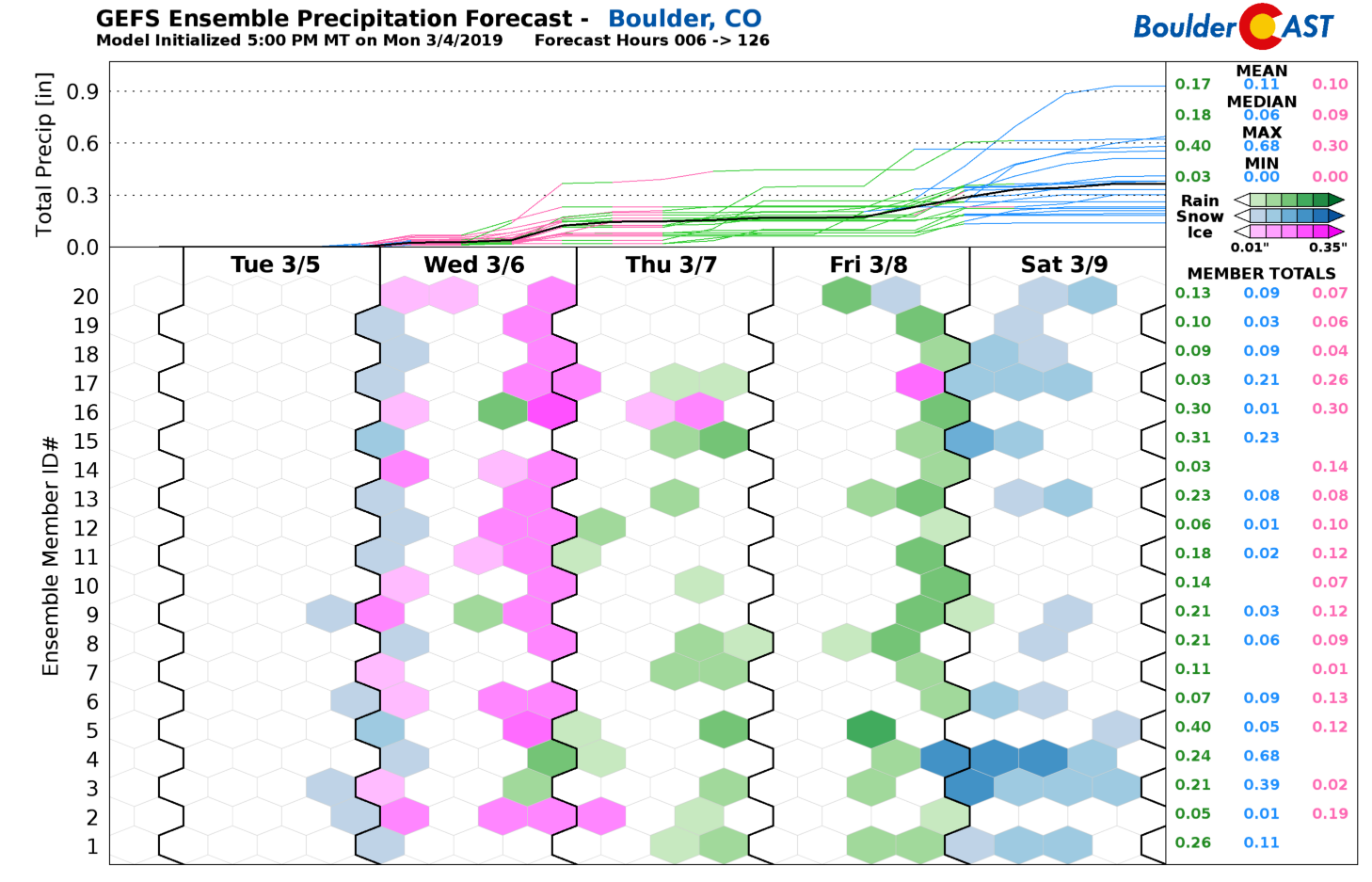
GEFS precipitation chances this week
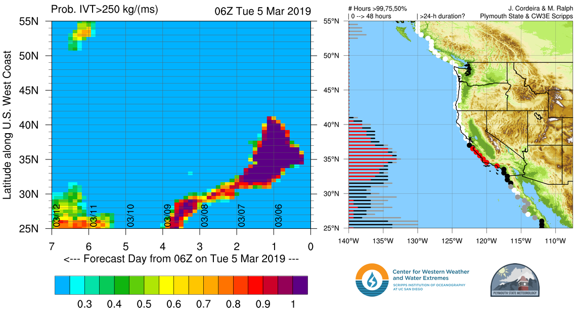
Similar to the past weekend, heavy snow will again be possible in the Mountains of Colorado, especially Wednesday and Wednesday night when tropical moisture from another atmospheric river event will inundate Colorado. The graphic below shows the probability of atmospheric river conditions impacting various portions of the Pacific Coast. We see around 100% chance for portions of California from Tuesday mid-day into Wednesday mid-day. Some of this moisture will then propagate into Colorado Wednesday into Wednesday night. You can find more forecast graphics for atmospheric river events over at the UC-San Diego website.
Snow totals through the week will exceed a foot in many spots and ski locations. Pick your favorite resort and enjoy the powder for the upcoming weekend. Friday’s system will make Saturday skiing good as well!
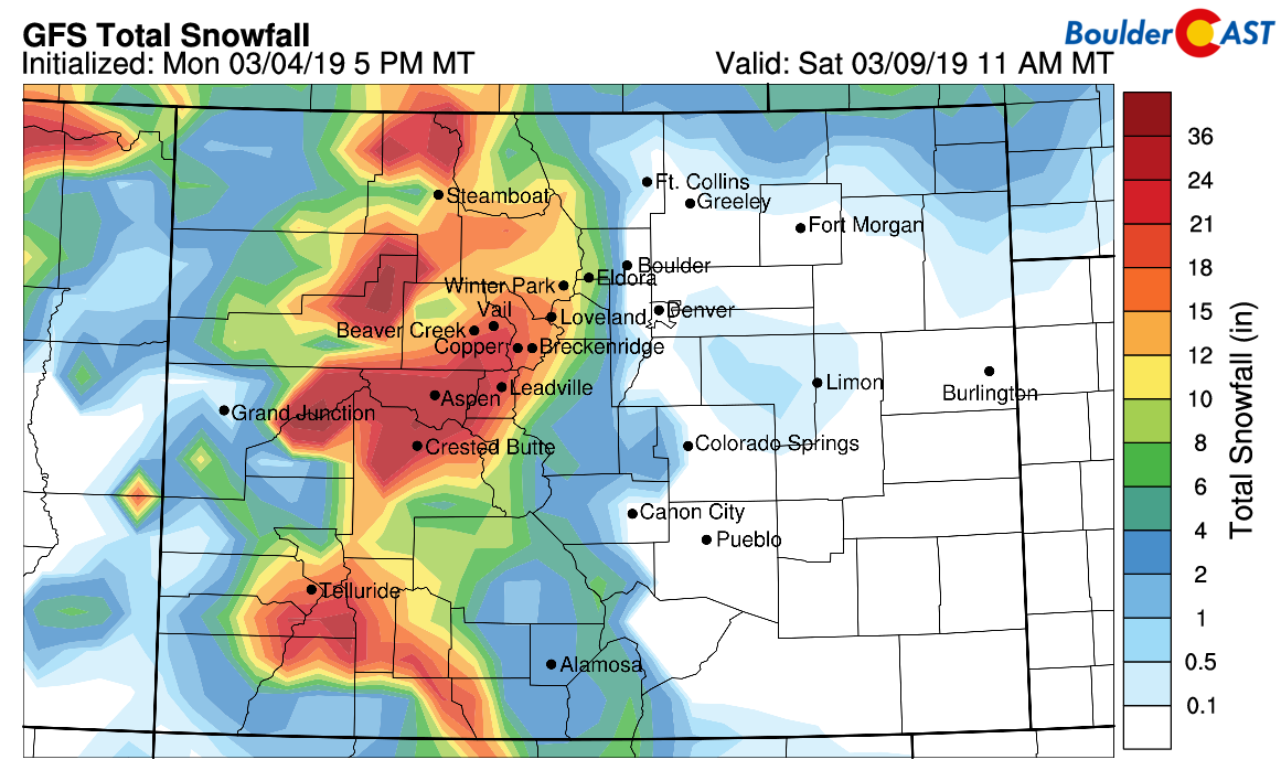
GFS total snowfall this week
Forecast Specifics:
Tuesday: Sunny skies giving way to high clouds late this afternoon. Highs in the lower 30’s on the Plains and middle 20’s in the Foothills.
Wednesday: Increasing clouds with a slight chance of rain/snow showers in the evening . Highs in the lower to middle 40’s for the Plains and lower 30’s in the Foothills.
Thursday: Decreasing clouds with sunshine taking over. Temperatures should warm to near the lower 50’s in the afternoon for the Plains and lower 40’s in the Foothills.
Friday: Increasing clouds with highs in the middle 50’s on the Plains and low to middle 40’s in the Foothills. A slight chance of rain changing to snow during the afternoon, evening, and overnight hours.
Saturday: A chance of light snow in the morning, otherwise cold and breezy with highs in the upper 30’s to lower 40’s for the Plains and upper 20’s in the Foothills.
High Country: Today is the only dry day for the mountains. Snow returns, primarily for the northwest part of the state tomorrow. A more significant event occurs on Friday into Saturday, with amounts exceeding 6+” in many areas. Check PowderCAST for updated forecasts for all the Colorado ski resorts.
DISCLAIMER: This weekly outlook forecast was created Monday morning and covers the entire upcoming week. Accuracy will decrease as the week progresses as this post is NOT updated. To receive daily updated forecasts from our team, subscribe to BoulderCAST Premium.

.
Share our forecast!


You must be logged in to post a comment.