This week’s weather quiz topic examined the cause of the glaze of ice that formed on the trees on February 27th. Read on for some background information, the quiz results, and a deep dive into the answer.
These weather quizzes and resulting discussions are normally Premium content. This quiz was open to all of our readers. Join Premium to get the complete BoulderCAST experience, including these quizzes, our daily forecast discussion every morning, complete 6-day skiing and hiking forecasts, access to all of our Colorado-centric weather models and maps, additional storm updates and much more! If you love weather, you’ll love Premium. We promise! Plus it truly helps support our team’s efforts to add new features and content on a regular basis. Thank you!

BACKGROUND:
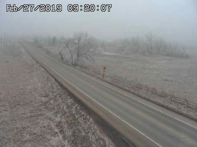
Once again, freezing fog shrouds the Denver Metro area as a very cold and shallow Arctic airmass crept in overnight. This webcam is from Highway 36 between Boulder and Lyons this morning.
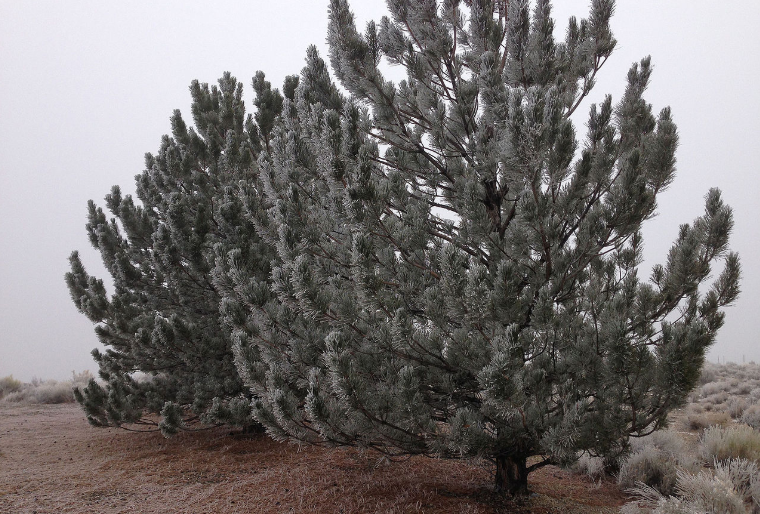
Most of the vegetation is encased in ice, which is indeed somewhat of a rarity for our area! One such sad-looking fir tree is shown below.
There are two entirely different physical processes which can lead to vegetation getting encased in ice as it has this morning. One is much more common in Denver than the other….
RIME ICE
Rime ice forms via riming, the process by which super-cooler liquid cloud droplets freeze on contact with available surfaces. Riming occurs most significantly on the windward (upwind) side of objects, like trees. With close inspection, rime ice will appear chunky or clumpy.
HOAR FROST
Hoar frost forms via deposition, the process by which water vapor directly changes phase to solid ice, requiring a surface to do so. Hoar frost generally favors the leeward (downwind) side of objects, like trees, and typically has a distinct, snowflakey appearance.
THE QUESTION:
On the morning of February 27th, was the icing that formed on the trees around Boulder and Denver rime ice or hoar frost?
TINY HINT (LITERALLY): The wind direction as the ice formed was pre-dominantly from the east. If you’re good with directions, the answer should immediately be apparent. That is, if you can find a half-iced tree!
.
THE ANSWER:
Rime Ice
On the morning of February 27th (and actually the 26th and 28th, too!), a shallow but dense layer of freezing fog formed across most of northeast Colorado. The view from atop the 6800-foot summit of Mt. Sanitas that day could possibly have been mistaken for a sunrise over the Atlantic Ocean, with a “sea of clouds” shrouding Boulder below.
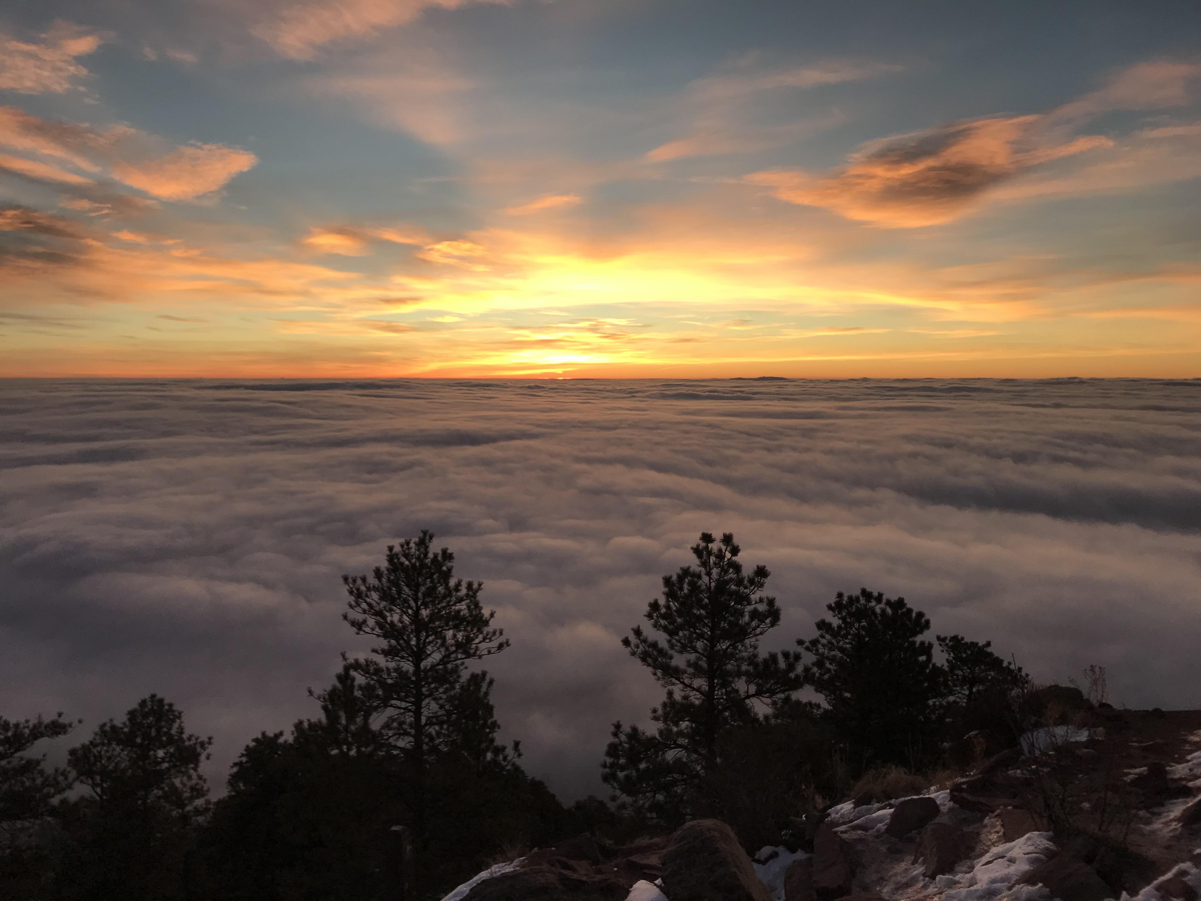
Freezing fog over Boulder, looking down from Mt. Sanitas (Photo Credit: Josh McClung)
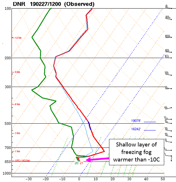
If we look at the weather balloon profile from Denver that morning, the data matches the photo quite nicely. The shallow layer of super-cooled cloud droplets had a top around 800 mb. This would be about 400 meters above Boulder, or an altitude of 6600 feet, just below the summit of Mt. Sanitas.
The key factor to determining whether the icy accumulation on the trees that morning was rime ice or hoar frost was the presence freezing fog….
Rime ice forms via riming, which is when super-cooled cloud droplets freeze on contact with a surface. Thus, rime ice REQUIRES freezing fog. Rime ice will appear clumpy and chunky, with seemingly no pattern. This is because the super-cooled cloud droplets are evenly distributed in the air and freeze randomly on the surface in this manner. The only noticeable tendency is that the side of the tree that the wind is hitting will have more rime ice than the other side.
Hoar frost on the other hand does NOT REQUIRE freezing fog and can form on totally clear, cold nights. Hoar frost is just an extreme version of normal frost which forms via deposition. Deposition is when water vapor directly sticks to surfaces to form solid ice crystals. Since hoar frost forms via deposition, it will follow a clearly organized pattern, molecule by molecule, “obeying” the angle of hydrogen bonds. This results in a crystalline structure that looks almost like a giant snowflake.
A closer inspection of the pine tree we pictured earlier clearly shows the icy glaze was rime ice (see below).
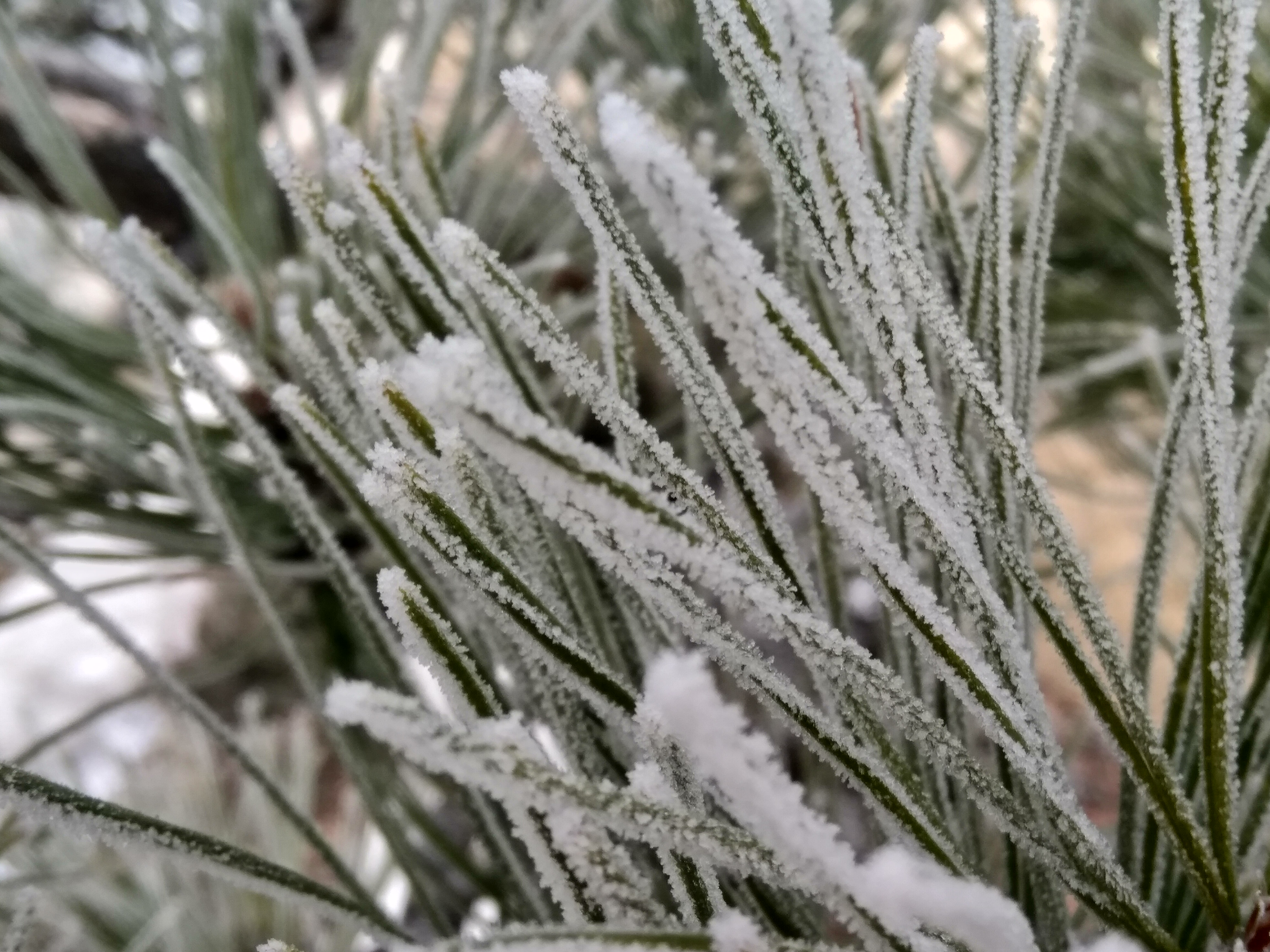
Rime ice on a pine tree in Boulder, Feb 27 2019
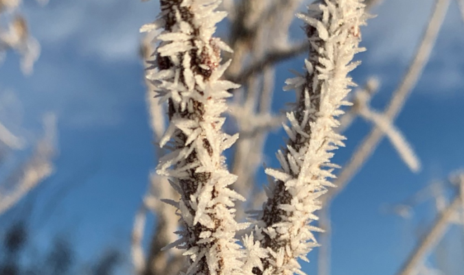
If the wind is a bit stronger (several mph) and the freezing fog persists for many hours, the rime ice can grow into spiky pillars facing into the direction the wind is coming from. The picture below occurred during another round of freezing fog the very next day (Feb 28) and is also rime ice, likely under slightly windier conditions.
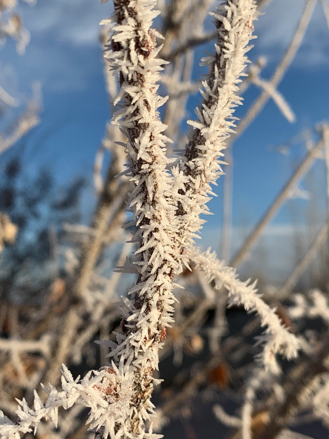
Rime ice on a thin branch in Berthoud, Feb 28 2019 (Photo credit: Ryan Heiland)
Based on the results below, 56% of quiz participants were correct…way to go!
.
Hopefully this quiz has helped you better understand the difference between rime ice and hoar frost. Neither of them are all that common in our area (something about fog not liking our high desert climate), but next time they do, you’ll know which is which!
Share this quiz:


You must be logged in to post a comment.