Last week’s highly-anomalous Arctic blast delivered the goods in terms of record cold and a decent snowfall across the Front Range. We discuss a few different aspects of this particular Arctic outbreak which make it stand out against Boulder’s 122 year historical record.
P
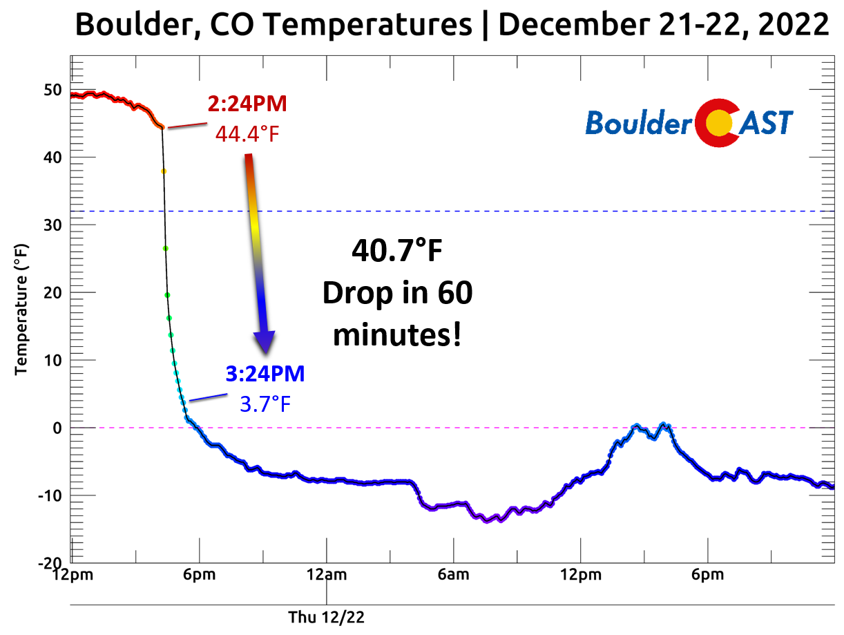
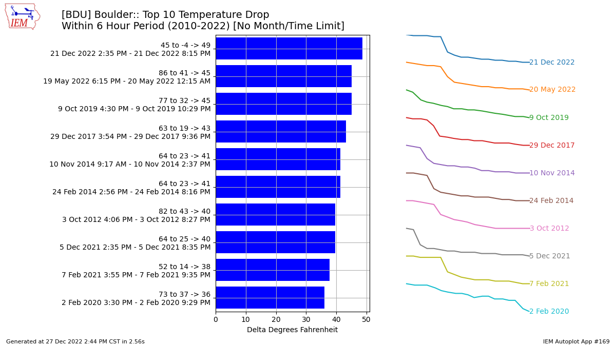
robably the most utterly impressive aspect of the entire event for our area was just how hard the Arctic cold front hit when it arrived on that fateful Wednesday afternoon. In our Premium update the morning of, we warned that it would “be a day to remember in Colorado weather — one that should be worthy of telling the grandkids about someday. We may never see a cold front this strong blow through again, especially considering the downslope winds which will be warming up the Metro area beforehand to give us an even greater temperature drop.” Despite models coming in weaker, we predicted that most areas would see a 30 to 40° drop in an hour’s time, and that’s exactly what unfolded across the Denver Metro area that day. Our station reported a drop of 40.7° in just one hour — from 44° to 4° in the blink of an eye!
A wave of dust helped to dramatize the arrival of the front, something that has become more common in the drought-infested past few years.
Inbound #haboob (dust storm) along very intense #Arctic cold front as viewed from @NCAR_Science Mesa Lab in Boulder. #cowx pic.twitter.com/zohVS4Xuuw
— Daniel Swain (@Weather_West) December 21, 2022
After that initial “shock and awe”, temperatures continued to fall slowly but steadily over the next dozen hours all the way down into the negative double digits. The dramatic plummet in temperature landed as one of the top 10 largest one-day temperature drops at the city of Boulder’s official climate station — going from 47°F early in the afternoon on December 21st to -18°F by sunrise on December 22nd — about 18 hours later.
Largest One-Day Temperature Drops in Boulder
1) 84°: January 25-26, 1903 | 64° to -20°
2) 70°: February 6-7, 1933 | 51° to -19°
3) 69°: April 5-6, 1995 | 73° to 4°
4) 68°: January 24-25, 1903 | 60° to -8°
5) 66°: December 16-17, 2016 | 59° to -7° & November 10-11,1911 | 65° to -1°
7) 65°: December 21-22, 2022 | 47° to -18° & 3 other times
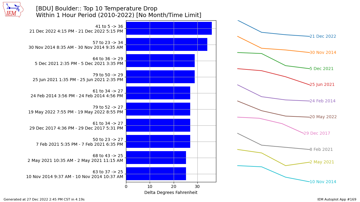
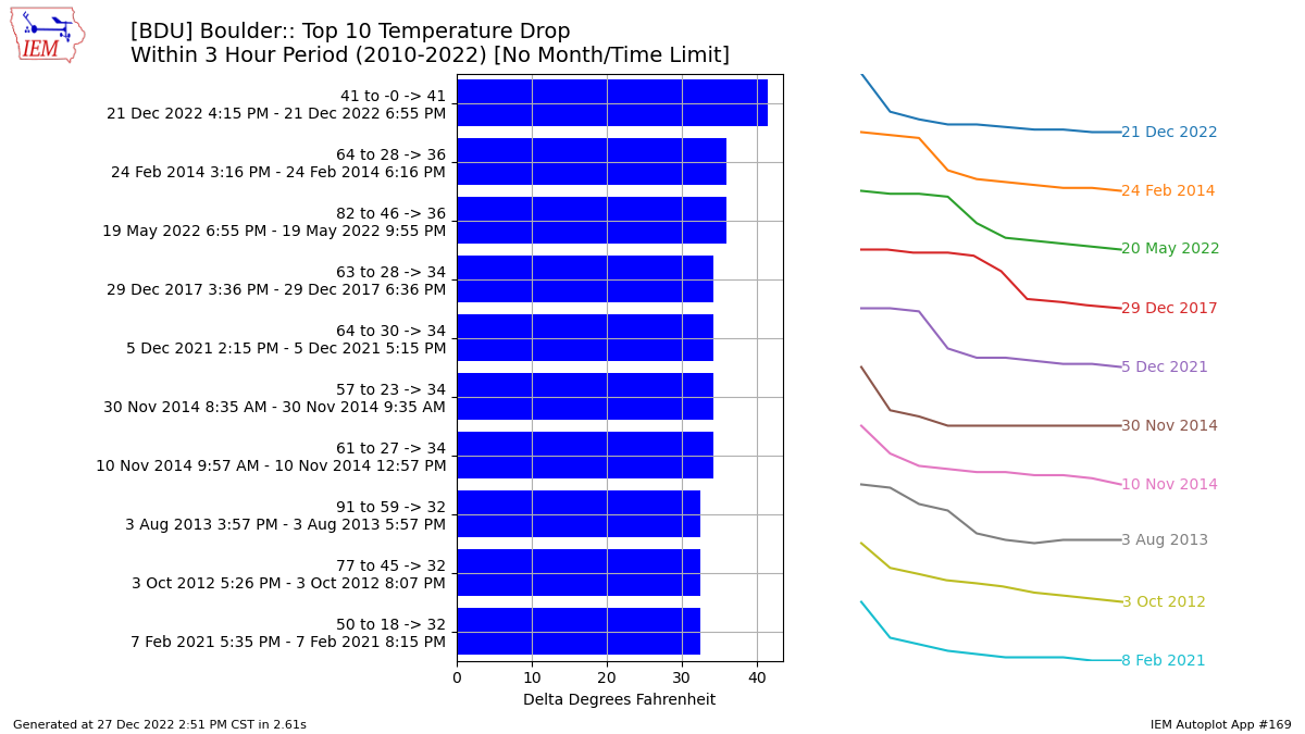
Unfortunately the official station does not record hourly data, which is a crying shame since this front would have nestled nicely amongst the all-time most rapid temperature drops for the city. Boulder Municipal Airport’s hourly data, which dates back only to 2010, indicates the temperature drop last week was at least the most rapid in the last 13 years over 1-hour, 3-hour and 6-hour timescales!
The absolute coldest temperature officially recorded in Boulder during the entire event, -18°F on the morning of December 22nd, was the coldest for the city in exactly 32 years and one of only 22 times -18°F was reached since the 1890s. It also tied for the 5th coldest temperature to occur in the month of December.
Coldest December Temperatures in Boulder
1) -24°F: 12/22/1990
2) -20°F: 12/20/1990 & 12/9/1919
4) -19°F: 12/12/1932
5) -18°F: 12/22/2022 & 3 other times
The observed minimum temperature on Thursday, December 23 2022 of -14°F was also a new record low for the date, ousting the prior value of -13°F set in 1990.
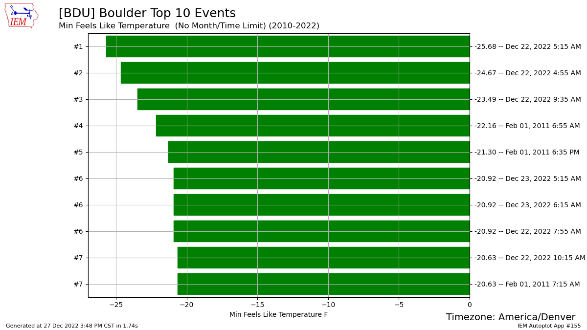
Seven of the top 10 coldest wind chill observations at Boulder Airport occurred last week as well, bottoming out at a bone-chilling -26°F early in the morning on Thursday December 22nd.
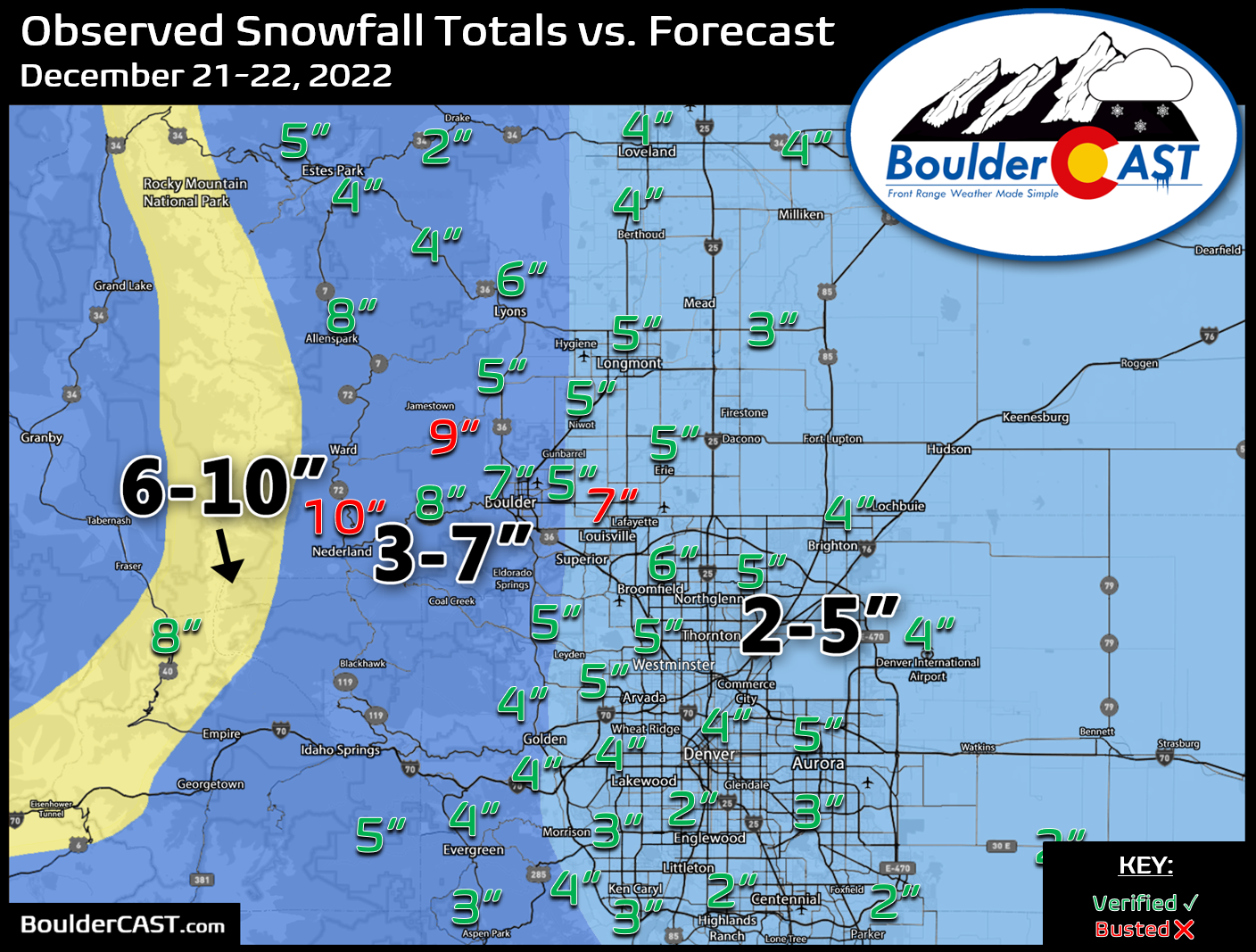
In addition to the bitter cold, last week’s Arctic blast was also unique in regards to how much snow fell alongside the frigid airmass as it settled in. Despite temperatures well below zero at the surface, moderate to at times heavy snowfall was reported across the Denver area. Typically this does not happen due to the extreme lack of moisture that embodies Arctic airmasses. This rare occurrence last week was owed to the fortunate alignment of the overhead jet stream which spawned the locally heavy snow bands. The jet stream doesn’t necessarily care what is happening at the surface — it allows for a tap into warmer air and moisture sources higher up in the atmosphere.
Sub-zero temperatures and heavy snow! Not two things that you ever expect to see together! Currently falling at 1.5" per hour rate #COwx #Boulder pic.twitter.com/v91kn8meVi
— BoulderCAST Weather (@BoulderCAST) December 22, 2022
The 6.2″ of snow that fell in Boulder late on December 21st and into the 22nd registers as the second most snowfall ever on day where the temperature also dropped below -12°F.
Snowiest Days with Coincident Low Temperature Below -12°F in Boulder
1) 6.5″ and -18° on 2/4/1989
2) 6.2″ and -18° on 12/22/2022
3) 3.7″ and -14° on 12/20/1990
4) 1.7″ and -24° on 2/5/1989
5) 1.2″ and -13° on 2/2/2007
Overall last week’s historic cold snap (and accompanying heavy snow) was something to behold. Hopefully you got to experience it in one way or another — maybe being outside as the dust-laden front rolled through like a freight train, or by performing the age-old “airborne boiling hot water” experiment. We may not see something like this again for another 32 years, or perhaps longer given the warming climate…
Get BoulderCAST updates delivered to your inbox:
Enjoy our content? Give it a share!


You must be logged in to post a comment.