Happy Wednesday! Ingredients are already starting to come together for a quick shot of precipitation this evening with rain changing to heavy wet snow across the entire area. Forecasting Front Range snow isn’t always as easy as we may make it look and tonight’s forecast is a prime example with uncertainty still remaining rather high. Models have been very inconsistent with this wintry system thus far, but the overall recent trend has been towards more snow for everyone. We discuss the latest developments on the storm and the expected snowfall totals across the Boulder-Denver area. Unfortunately the timing of everything will have implications on the Wednesday evening commute.
Premium Storm Update (12/28/22 3:00PM): Things are coming together nicely across the central Rockies and the ongoing forecast for rain changing to snow this evening remains on-track. Recent model runs continue to advertise copious moisture dumping on the Front Range tonight, greater than 0.5″ in many areas, and thus we’re expecting almost everyone will pick up several inches of wet snow from this storm. Read on for the latest timing on the change-over from rain to snow and an updated look at snowfall totals, including which spots could have a chance at double digit snow amounts! READ HERE
O
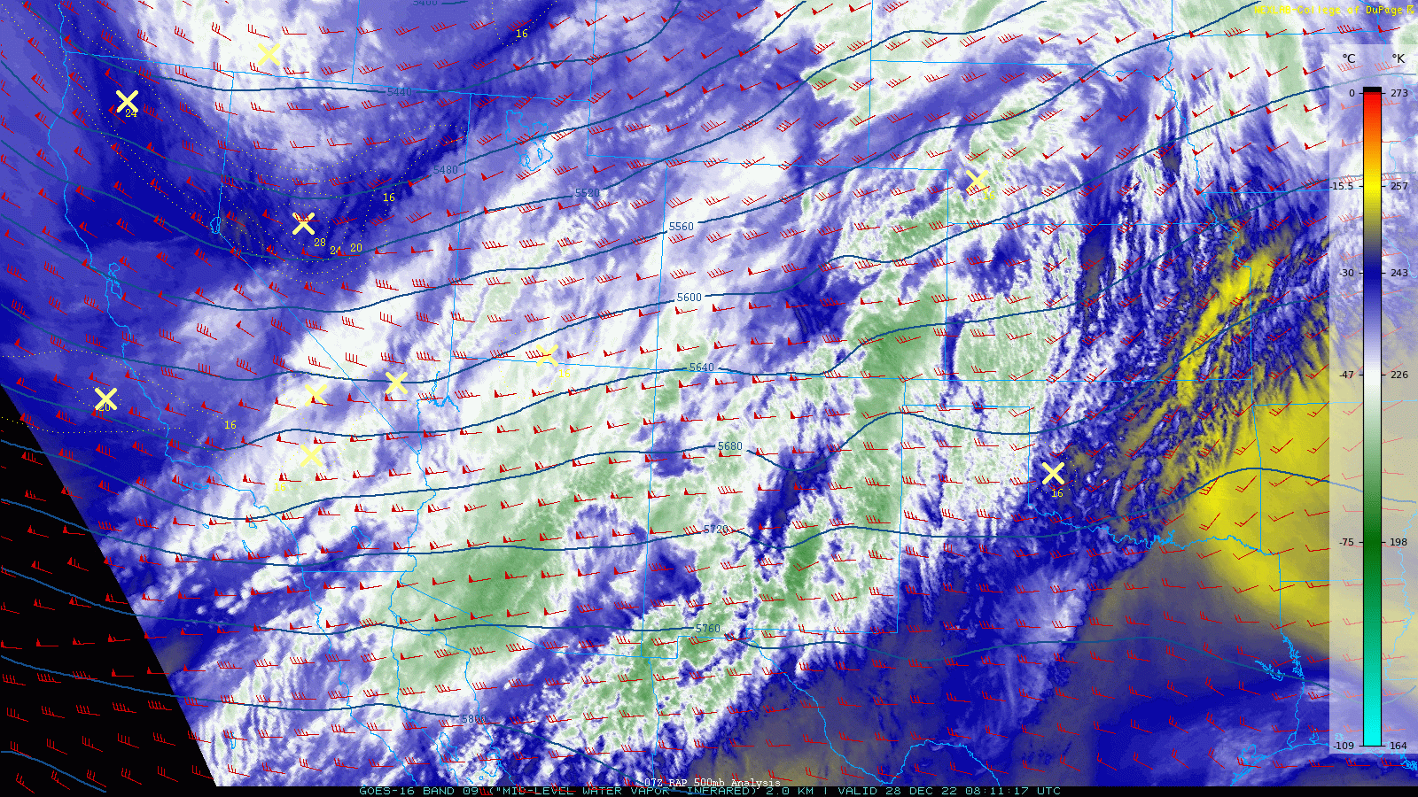
ur next wintry system is already making a beeline towards Colorado as of early Wednesday morning. The unimpressive trough axis is currently located over Nevada as of writing and will close in on Colorado through the day and into the overnight. GOES-East water vapor imagery shows a plethora of moisture streaming into Colorado from the southwest out ahead of this trough. This same moisture has been producing snow in the Mountains since yesterday afternoon. The heaviest snow has been intercepted by the favorable orientation of the San Juans with lighter snow falling across the I-70 region and Front Range Mountains thus far.
Wednesday will be fairly mild east of the Mountains (but not as mild as Tuesday when everyone got into the 60s) with temperatures topping out in the 50s under mostly cloudy skies. In fact, due to some downslope winds overnight, some areas like Boulder and Broomfield are nearly this warm already at sunrise!

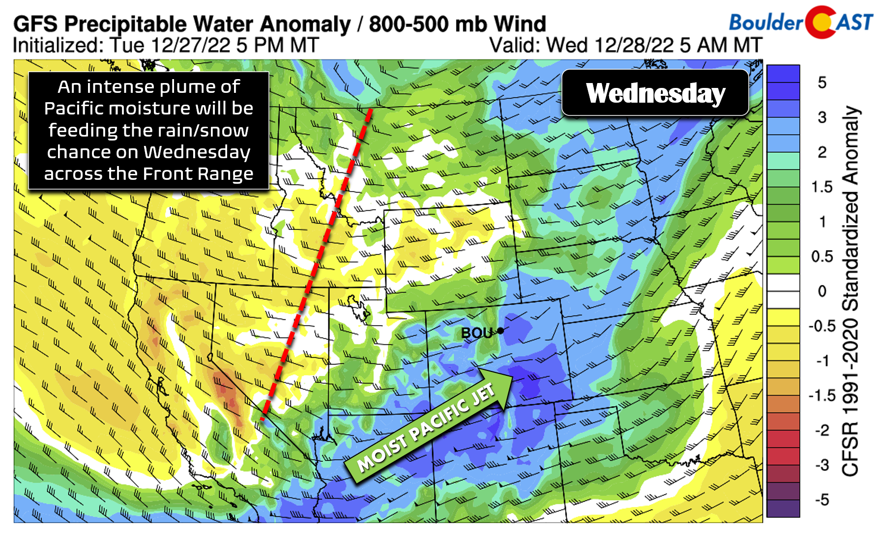
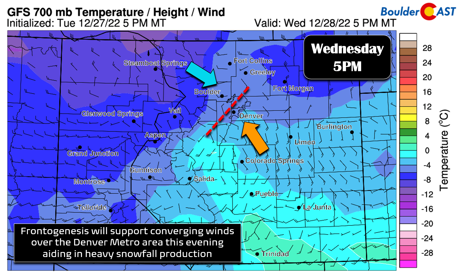
By afternoon, we will start to see the juicy ingredients come together across the Front Range for what could very well be an interesting evening with rain changing to heavy wet snow! The moisture is already in-place this morning, but the second ingredient to arrive will be a weak cold front during the afternoon hours which will turn low-level winds towards an upslope direction for the Denver Metro area. This should start to spread rain showers across the lower elevations with a rain/snow mix in the Foothills by late afternoon.
Mid-level frontal forcing, upper-level lift and pockets of instability will arrive right around sunset and overlap across the area through the bulk of the evening hours creating an absolute mess of a forecast for us with heavy snowfall rates up to 2″ per hour possible!
Rain will transition to a wet snow for everyone within a few hours. Unlike last week’s Arctic blast, however, this system doesn’t have nearly as much cold air to work with — not even the air behind the cold front is actually all that cold. In rather rare fashion, there will be a few hours of December rainfall at the onset. As temperatures naturally cool towards sunset and precipitation rates increase causing further cooling, things will begin to change over to snow and a heavy/wet snow at that. The timing of the full change-over looks to be between 4PM (lower Foothills and Palmer Divide) and 5-7PM (Boulder-Denver area).

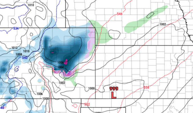
The trickiest part of the forecast is pinning down potential snowfall amounts as the models have been all over the place with this system the last few days, and that is probably an understatement — not just in terms of snowfall but in terms of raw precipitation that is on the table. It seems the models are starting to come into better agreement now as short-range guidance gets a better look at things, and like it or not, that agreement is leaning towards higher snowfall totals! However, our team’s confidence remains fairly low given that there is still considerable model spread. For example, the latest prediction from the HRRR model has anywhere from 6 to 10″ of snow falling over the Metro area with this event!
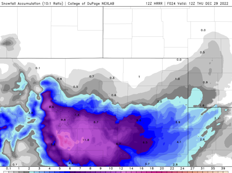
Other short-range models are less bullish, but they also display the same higher signals. The NAM-NEST and RAP models have more like 2-6″ of snow for the area.

Medium-range models have definitely come up with amounts over their last few runs, with most now producing anywhere from 2-7″ across the Denver Metro area.
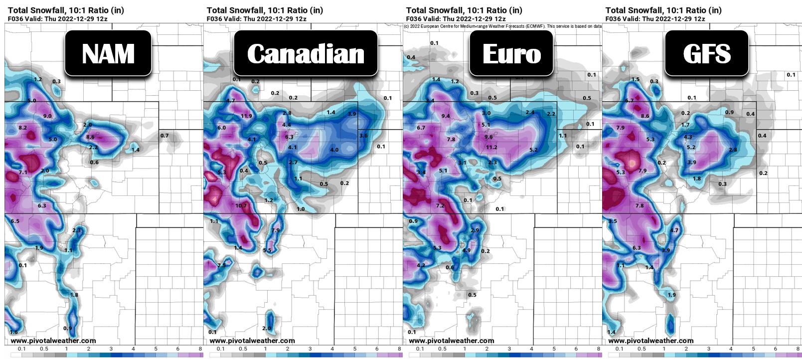
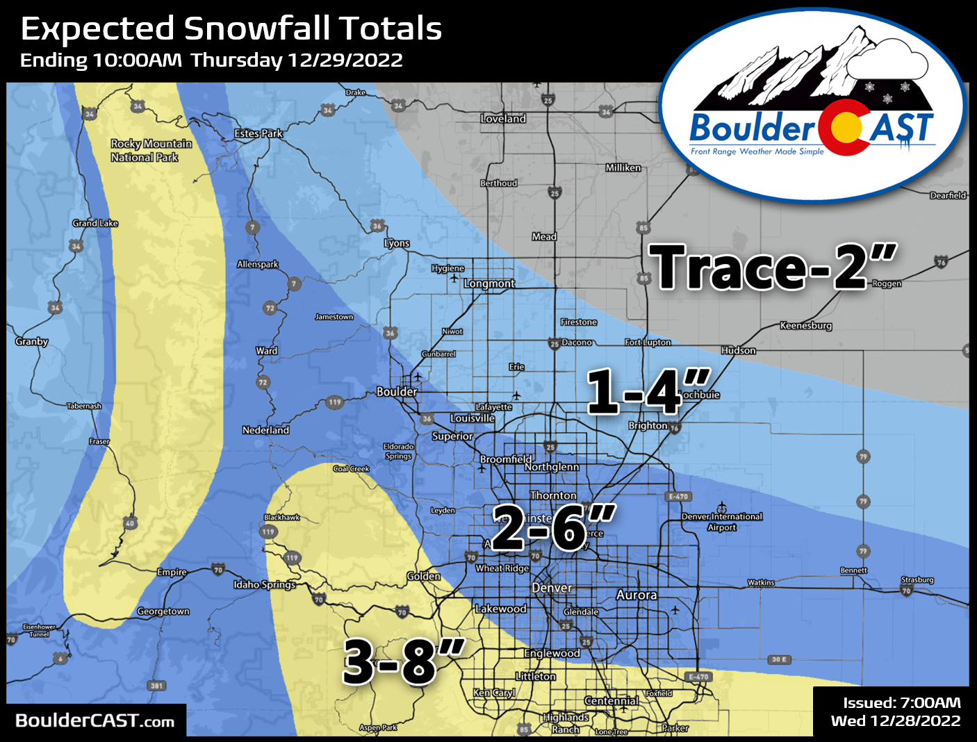
It’s clear from how the models have been handling things that this event is right on the very cusp of being a sizable snow-producer for Boulder and Denver (3 to 7 inches or more). However, it’s definitely a fine line with this one — there are plenty of outcomes which lead to 1 to 2 inches of snow or less for much of the area, and those are still a real possibility. Making a snowfall forecast for this evening is a bit like playing a drunken game of darts. Given all the factors in play — including rain at the onset, the change-over timing, warmer temperatures leading to lower snow ratios and more melting, the presence of near-record atmospheric moisture for late December, and the potential for 2″ per hour snowfall rates — our best-guess snowfall forecast is summarized in the map below. The highest snowfall totals will likely be in the southern suburbs and southern Foothills. Lesser snow amounts are expected the further north and northeast you go. The heaviest snow will fall from about sunset through the late evening, with snow then coming to an end after midnight from north to south.
Winter Weather Advisories have been posted by the National Weather Service south of Denver for the Palmer Divide and JeffCo Foothills. Unless models do a complete one-eighty throughout the course of the day, we expect to see these Advisories expand to encompass most of the Denver Metro area before the rain and snow begins. At the very least, there should be some overlap with heavy/wet snow and the evening commute, especially the latter part of said commute. Interstate 25 between Denver and the Springs is shaping up to be a disaster this evening — cancel any plans that way if you can. At this juncture, the same snowy fate could very well befall the Denver-Boulder area, too.

That’s all we’ve got for now. Leave work a little early if possible this evening and stay safe! We’ll have a Premium Storm Update posted later today reviewing the final model runs leading up the event and some last minute discussion. We definitely expect a few surprises tonight — whether those are booms or busts remains to be seen…
Get BoulderCAST updates delivered to your inbox:
Enjoy our content? Give it a share!


You must be logged in to post a comment.