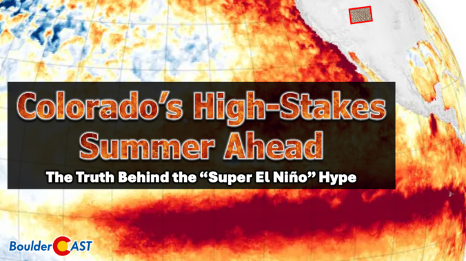
Colorado headlines have been buzzing about a looming “Super El Niño,” but the story behind the hype is far more layered than the headlines let on. Before leaning into the dramatic graphics and sweeping claims, it’s worth unpacking where this narrative actually came from and why one overzealous model run has taken on a life of its own. More importantly, we must consider what this all really means for our state as we limp into summer with record‑low snowpack, deepening drought, and a fire season that has already been sharpening its teeth. The truth is far more nuanced than the current online discourse suggests.
What You Need to Know
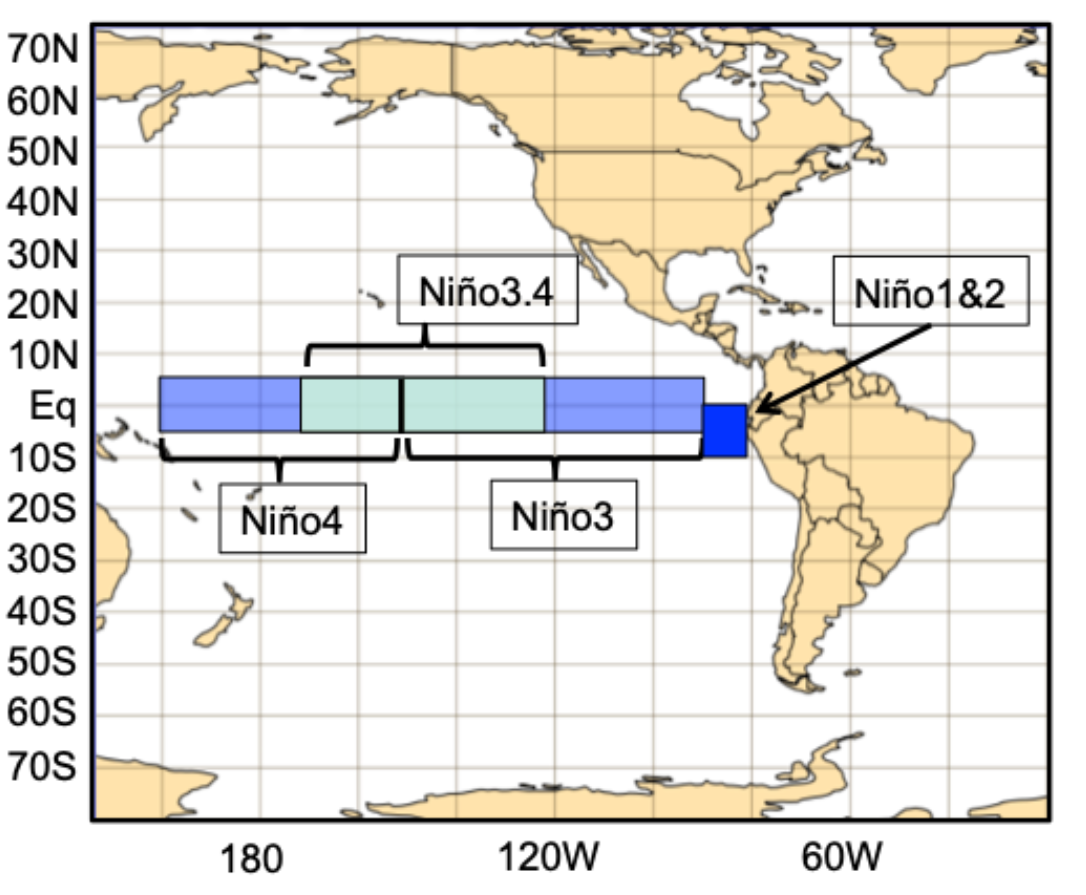
- El Niño basics: warm equatorial Pacific Ocean waters shift the global atmospheric circulation, influencing everything from tropical cyclones to Colorado’s monsoon rains and winter storms.
- “Super El Niño” hype has come from one source: a single ECMWF seasonal ensemble run, a model with a long history of warm bias and poor spring ENSO skill.
- Euro model shows rapid warming: 95% of its 51 members form a “Super El Niño” by October, but this is likely inflated due to the a well-known spring predictability barrier.
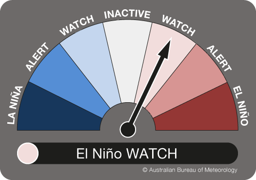
- NOAA is urging caution: El Niño is likely to form this summer, but outcomes range from a non-event to very strong one, with a “super” event dependent upon continued westerly wind anomalies along the Equator that are far from guaranteed.
- An El Niño will almost certainly emerge by the end of summer: subsurface heat is building basin‑wide across the Pacific and La Niña’s remnants have fully eroded.
- Colorado enters the summer in crisis: the worst snowpack on record (19% of normal), 95% of the state in Drought, and nearly half in Extreme or Exceptional Drought, the highest since the week of the Marshall Fire.
- El Niño summers favor a cooler, wetter monsoon: July through September precipitation jumps nearly 30% in El Niño years in Boulder, with temperatures running 2–3°F cooler (compared to La Niña).
- Early monsoon fire danger will be high: drought‑stressed fuels plus dry lightning mean a spike in lightning‑caused wildfire potential before meaningful moisture even arrives.
- The outlook for next winter is less certain, but optimistic: While El Niño can lead to above normal snowpack for some of Colorado, it’s not that simple. However, literally any outcome would offer improvement over what we just endured this winter and that alone is reason for hope.

Go Premium, get all the perks.
Daily Forecast Updates
Get our daily forecast discussion every morning delivered to your inbox.
All Our Model Data
Access to all our Colorado-centric high-resolution weather model graphics. Seriously — every one!
Ski & Hiking Forecasts
6-day forecasts for all the Colorado ski resorts, plus more than 120 hiking trails, including every 14er.
Smoke Forecasts
Wildfire smoke concentration predictions up to 72 hours into the future.
Exclusive Content
Weekend outlooks every Thursday, bonus storm updates, historical data and much more!
No Advertisements
Enjoy ad-free viewing on the entire site.
Where did the “Super El Niño” talk even come from?
There’s been no shortage of breathless headlines lately. National outlets, local news, and even casual weather chatter around Colorado have all latched onto the idea that a “Super El Niño” is brewing for late 2026 and that it will be our drought-busting savior. It all sounds very promising, but the truth is far less certain.
Most people don’t realize that most of the “Super El Niño” narrative traces back to a single source: the European Center’s seasonal forecast ensemble run back on April 1st 2026. That’s the only model suite suggesting such a rapid surge into “Super El Niño” territory right now. And it’s a model with a long history of running too warm, especially when it’s initialized in early spring.
So yes, the recent hype has a starting point. It’s just not a very reliable one.
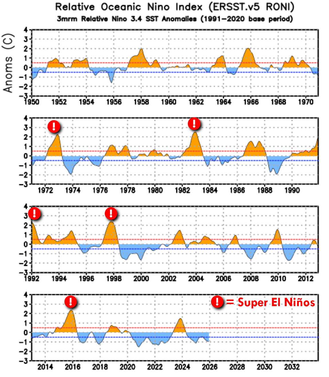
NOTE: Just to be clear, “Super El Niño” isn’t a technical term per se, but instead is just something forecasters use to refer to the strongest of the strong El Niños. It’s generally agreed to be Niño 3.4 region temperature anomalies of +2°C or higher. The most hype-inducing outlets will call these “Godzilla El Niños”. For context, there have been 5 Super El Niños in the last 75 years, repeating on average about every decade or two. The last one was in 2015.
A Quick Refresher: What Is El Niño?
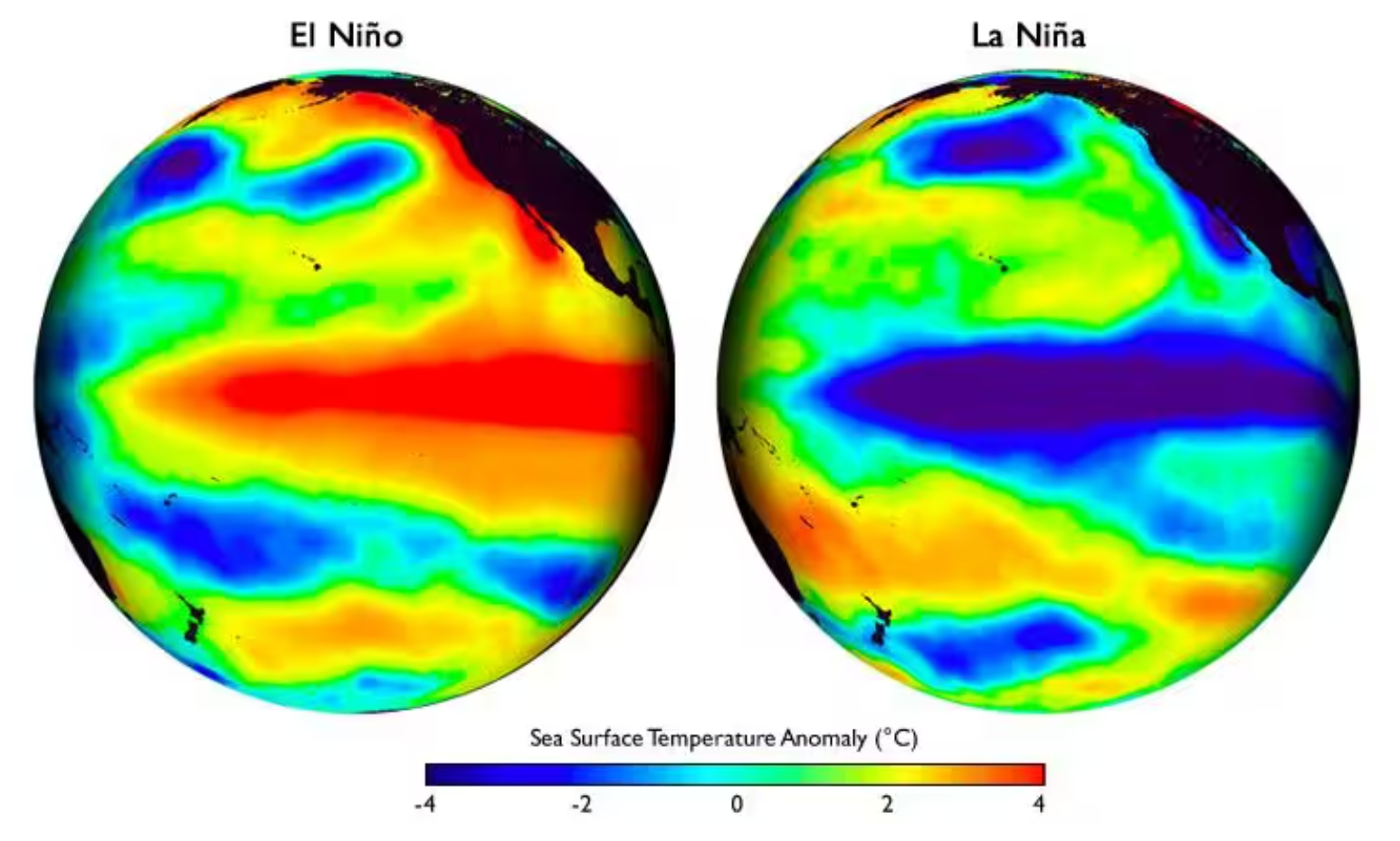
El Niño describes a period when the equatorial Pacific’s surface waters warm several degrees above normal, while La Niña is the flip side, defined by an equally broad swath of cooler‑than‑average water. These shifts might look subtle on a map, but stretched across thousands of miles they signal a wholesale rearrangement of heat within the world’s largest ocean.
Because the Pacific is the dominant engine of Earth’s climate, these warm‑and‑cool phases don’t stay confined to the tropics. They reorganize where thunderstorms erupt, reshape the jet stream’s path and intensity, and send atmospheric ripples across the globe. The downstream effects touch nearly everything—monsoon timing, hurricane activity, winter storm tracks, and seasonal temperature patterns. ENSO isn’t just another climate oscillation; it’s the backbone of long‑range weather/climate forecasting, the organizing principle we meteorologists lean on to interpret global trends months in advance.
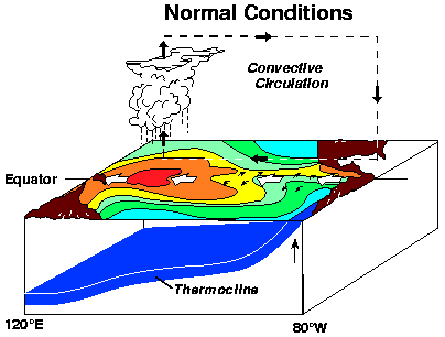
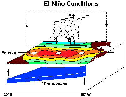
El Niño itself develops when the trade winds weaken, allowing warm water to slosh eastward and suppress the usual upwelling of cold, nutrient‑rich water (as shown in the 3D diagram above). Centuries ago, Peruvian fishermen noticed their catch dwindled around Christmastime during these warm episodes. They named the phenomenon El Niño, “the little boy,” a nod to baby Jesus—an observation that has since became the foundation of modern climate science.
Today we understand just how far‑reaching ENSO’s influence is. It shapes hurricane seasons, modulates monsoon strength, and even helps steer the winter storm patterns that determine Colorado’s snowpack. When the Pacific shifts, the atmosphere responds across the entire planet.
So Where Did the “Super El Niño” Chatter Come From?
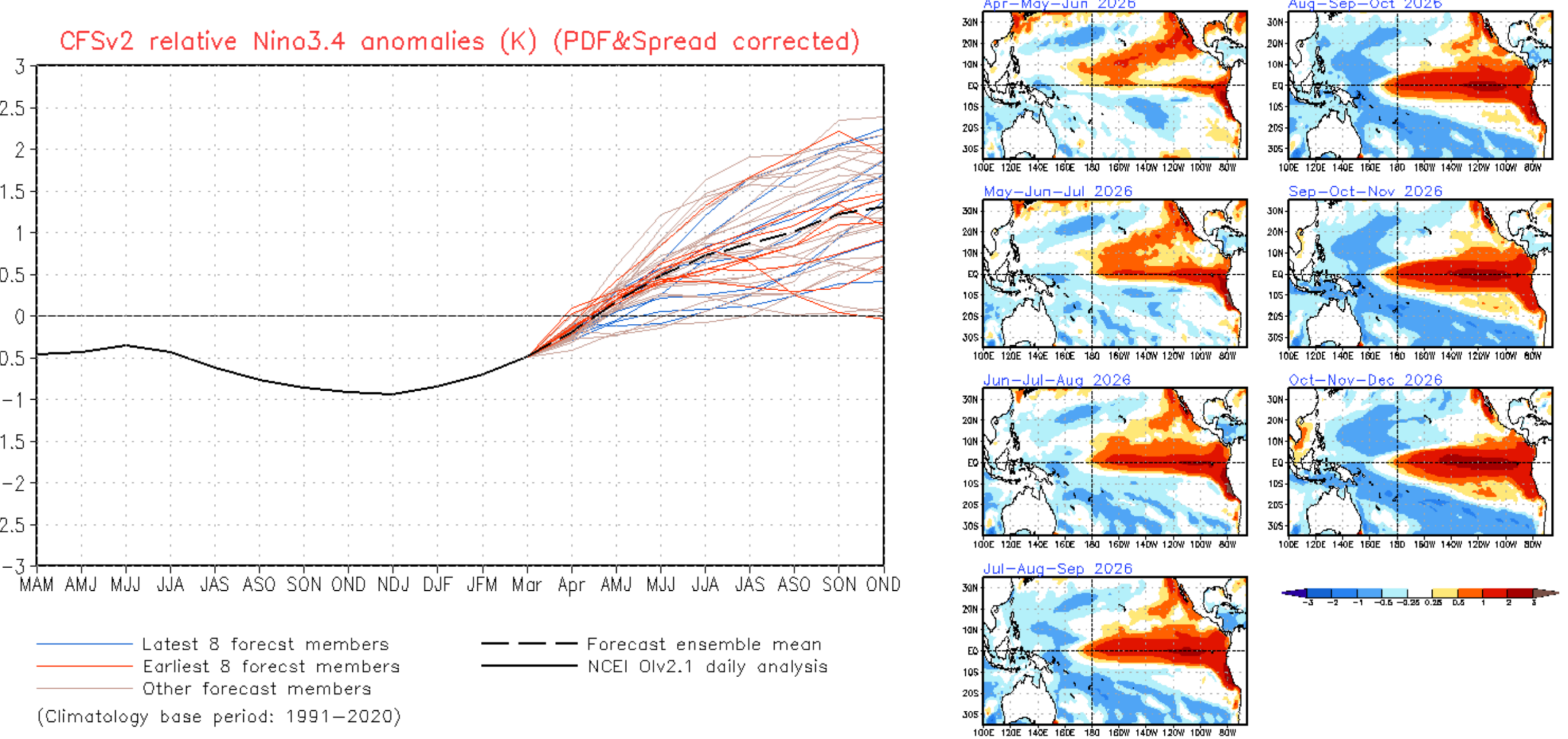
We present to you the single graphic that has drummed up all the hype and has sent shockwaves across the world: The Niño 3.4 sea-surface temperature anomaly forecast plume from the European ensemble initialized on April 1st 2026.
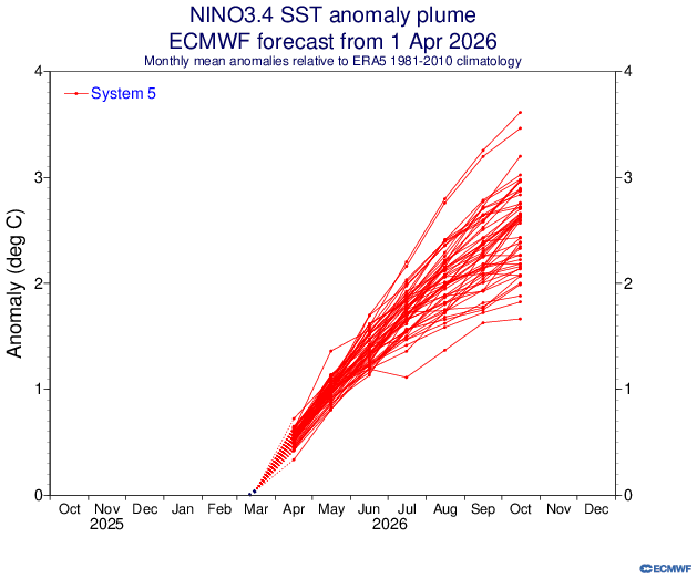
This particular ensemble is predicting a rapid warming of ocean surface temperatures in the coming months across the Niño 3.4 region of the equatorial Pacific Ocean (cyan shaded area below).
The ENSO-Neutral conditions present now in early April are predicted by this model to transition rapidly to an intense El Niño by late summer with sea-surface temperature anomalies soaring above 2°C, with even a few runs landing above 3°C. This ensemble is strongly suggesting this will happen, with approximately 95% of its 51 members forecasting a “Super El Niño” to be in place by October.
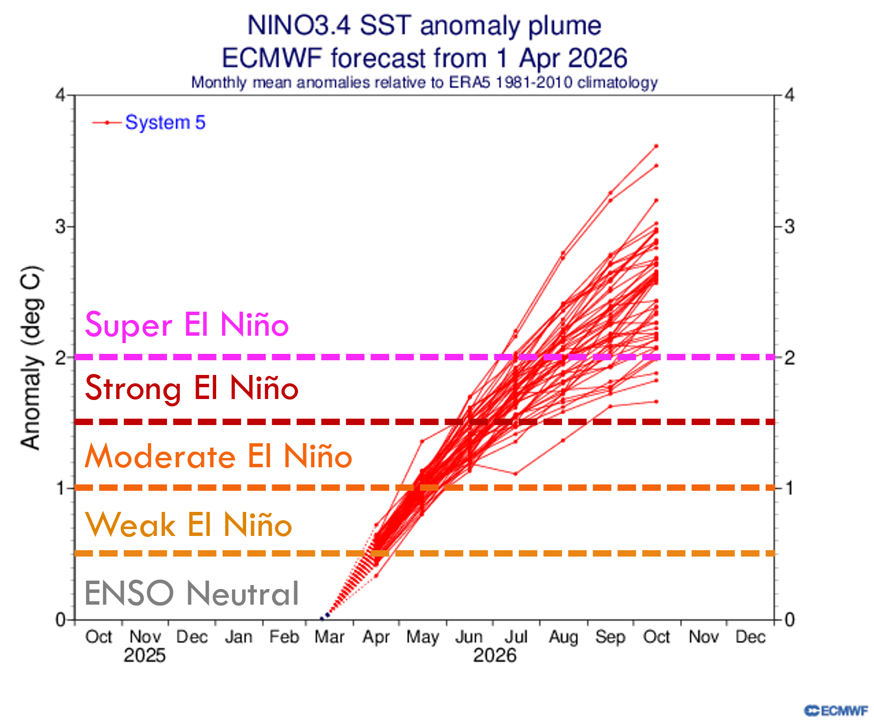
If you only saw that one graphic, you’d think the case was closed.
But here’s the reality…
The Euro seasonal model has a warm bias.
For nine Aprils in a row now it has forecast ENSO conditions too warm for the upcoming years. Seven of those nine were off by more than half a degree Celsius. Only 2023 and 2024 were even close. Compare below the red lines (member forecasts) to the blue dotted lines (observed conditions).
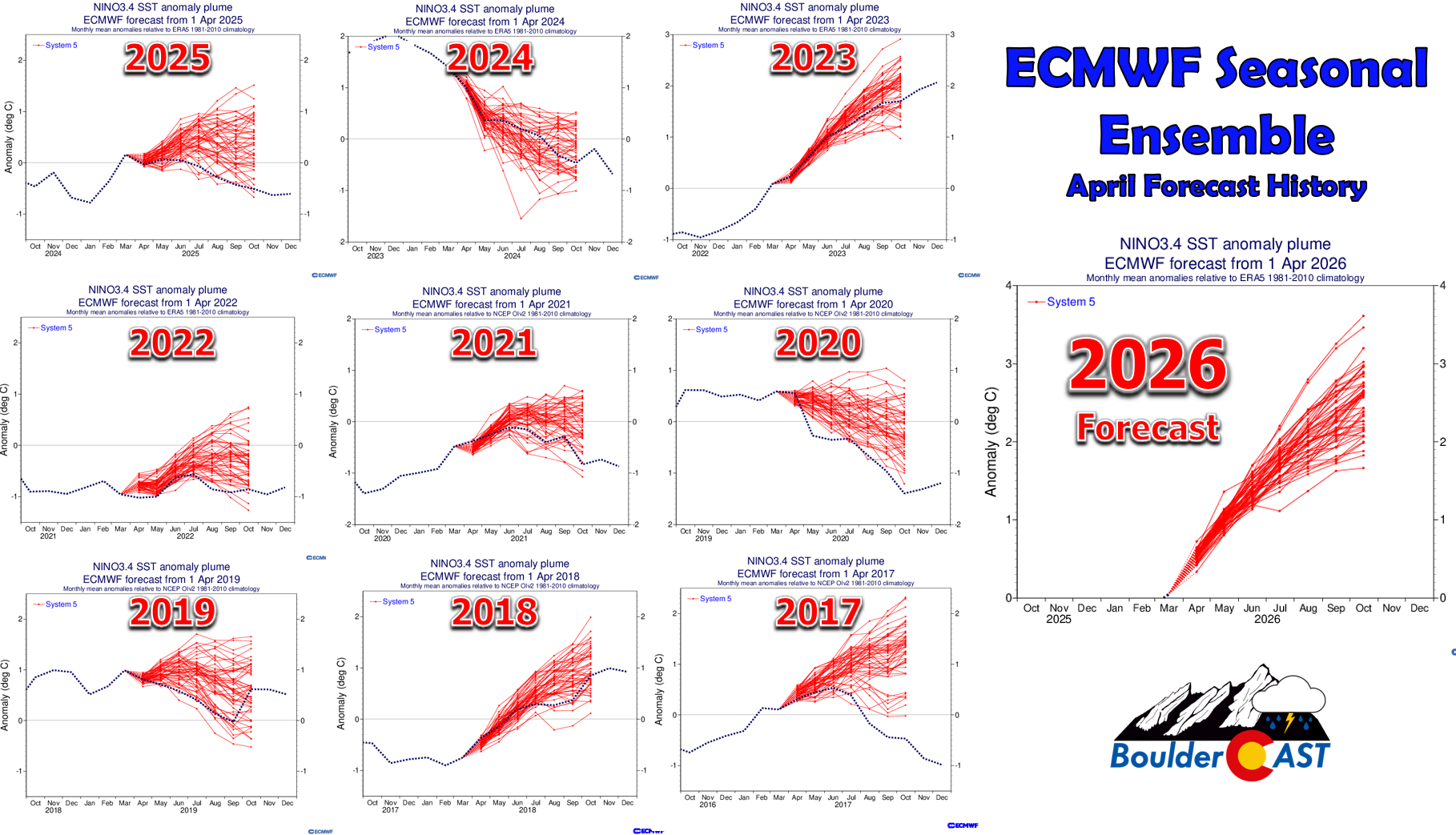
April sits squarely inside the ENSO spring predictability barrier.
Furthermore, we now reside in what is known as the ENSO spring predictability barrier, a well‑documented period from roughly March to May when ENSO models lose skill because the ocean–atmosphere system becomes unusually noisy and transitional. Subsurface heat content, trade‑wind patterns, and feedbacks that normally provide clear-cut predictor signals become harder to interpret, making forecasts for the following autumn and winter especially unreliable. In practical terms, April outlooks can describe the near-term ENSO trend quite well (i.e. for summer) but struggle to lock in what will happen six or more months down the road for the upcoming winter. This uncertainty has been reiterated by the NOAA Climate Prediction Center in their most recent ENSO diagnostic discussion published on April 9th. They state:
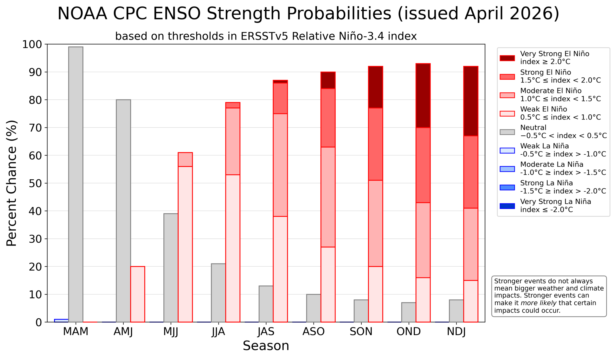
“El Niño is likely because of increasing subsurface temperature anomalies and recent westerly wind anomalies over the western Pacific Ocean. However, the possible outcomes range from ENSO-neutral to a very strong El Niño during the upcoming Northern Hemisphere winter. The possibility of a [super] El Niño (1 in 4 chance of NINO 3.4 ≥ +2.0°C) largely depends on the continuation of westerly wind anomalies across the equatorial Pacific throughout the Northern Hemisphere summer months, which is not assured. In summary, ENSO-neutral conditions are present and are favored through April-June 2026 (80% chance). In May-July 2026, El Niño is likely to emerge (61% chance) and persist through at least the end of 2026.”
In other words, El Niño is on the way, but its long-term strength is still uncertain.
What We Can Say With Confidence
The leftover cool pool from last winter’s fading La Niña has collapsed. It’s gone and El Niño will almost certainly develop this summer. Subsurface heat is building across the entire equatorial Pacific.
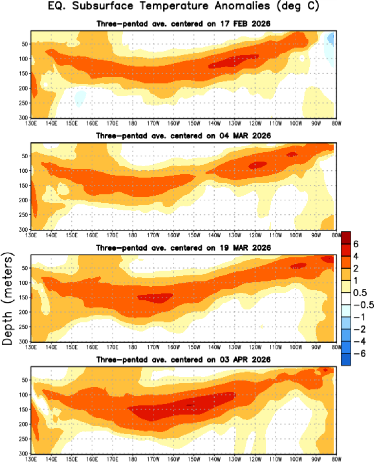
Warm anomalies are already surfacing in both the western and eastern Pacific, the former of which is currently fueling Super Typhoon Sinlaku near Guam in the western Pacific in April!
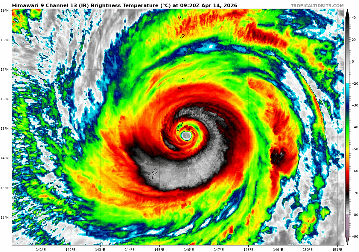
Infrared satellite animation of Super Typhoon Sinlaku near Guam on April 14, 2026 | TropicalTidbits.com
The current observations strongly support El Niño emerging by July or August, right as Colorado enters monsoon season. Whether it becomes weak, moderate, or strong heading into winter is still unclear. A “Super El Niño” remains a low‑probability outcome. In fact, only two of NOAA’s Climate Forecast System ensemble members are predicting a temperature anomaly greater than 2°C right now by the end of the year.
Colorado’s Dire Setup Heading Into Summer
You’re likely already well-aware of our next topic, but this is where things get uncomfortable…
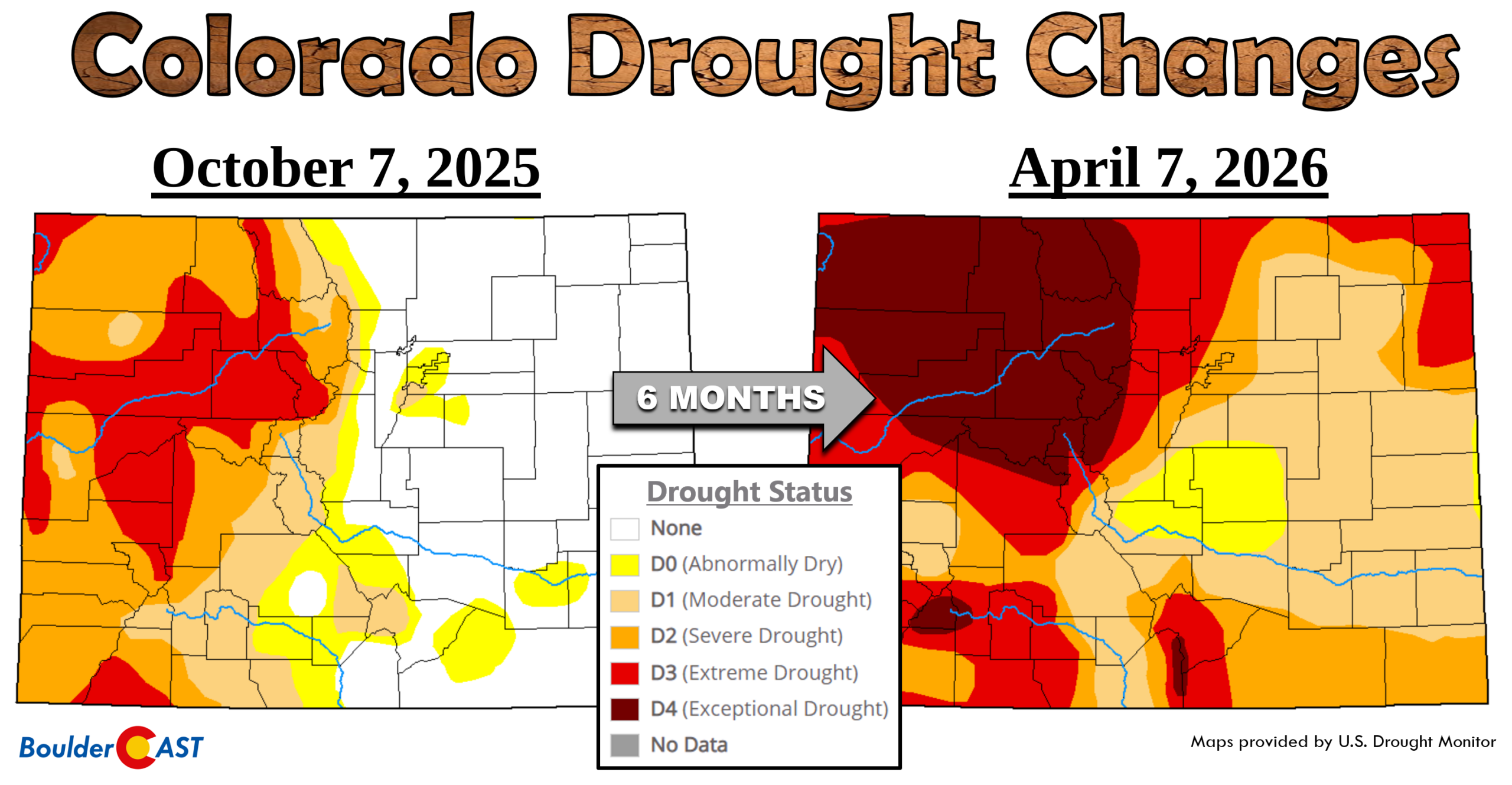
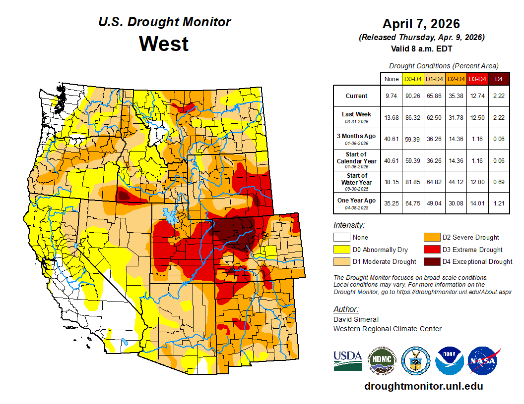
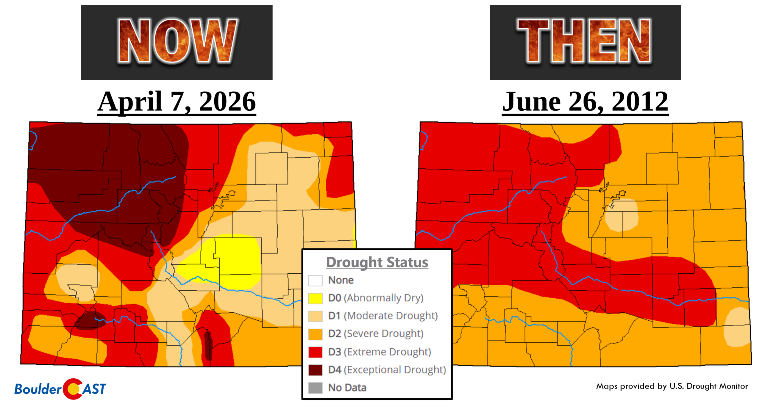
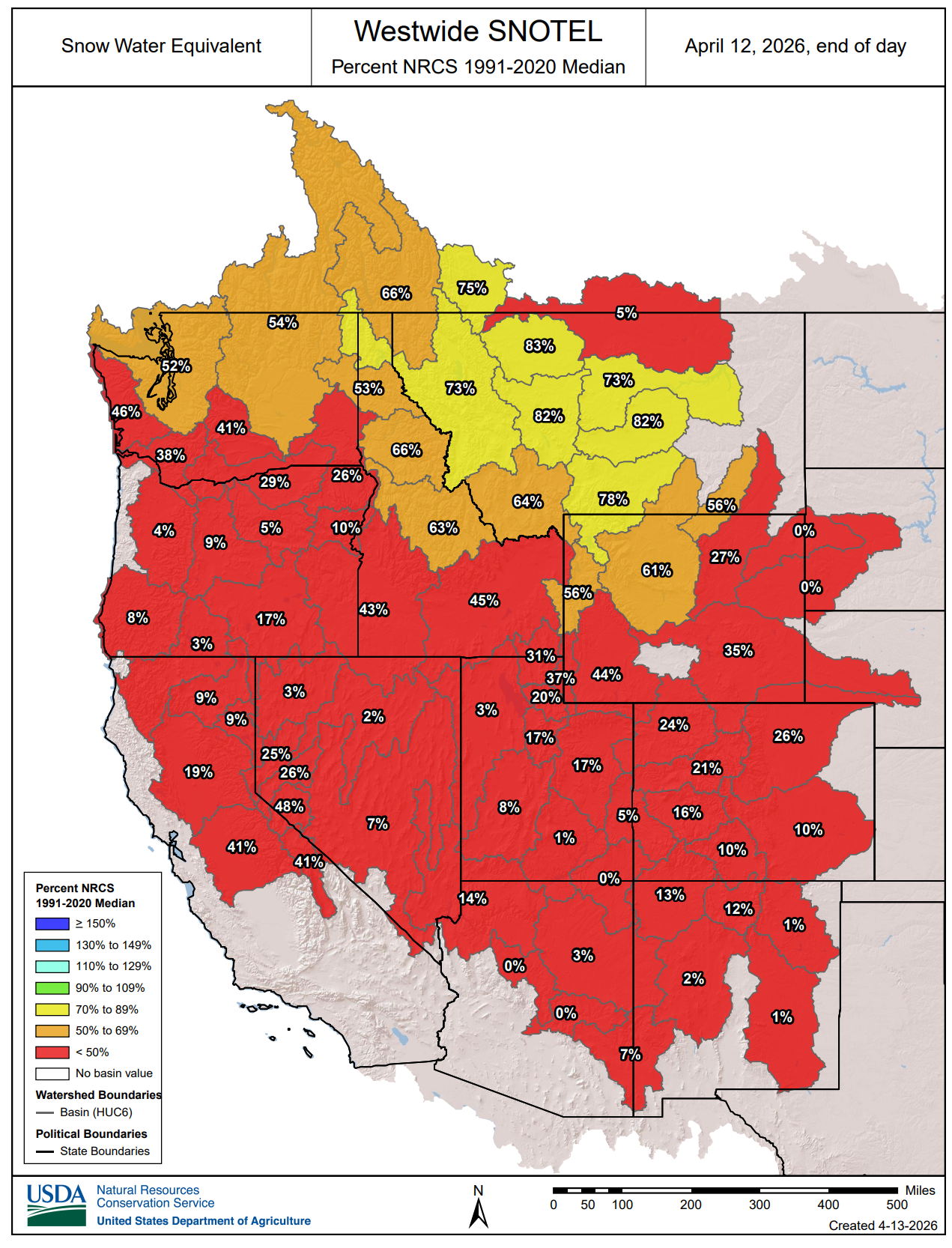
Colorado is coming out of what will likely be its worst snow season on record, with statewide snowpack at only 19% of normal as of April 13th. A warm, dry winter followed by a two-week unprecedented March heatwave wiped out what little snow remained.
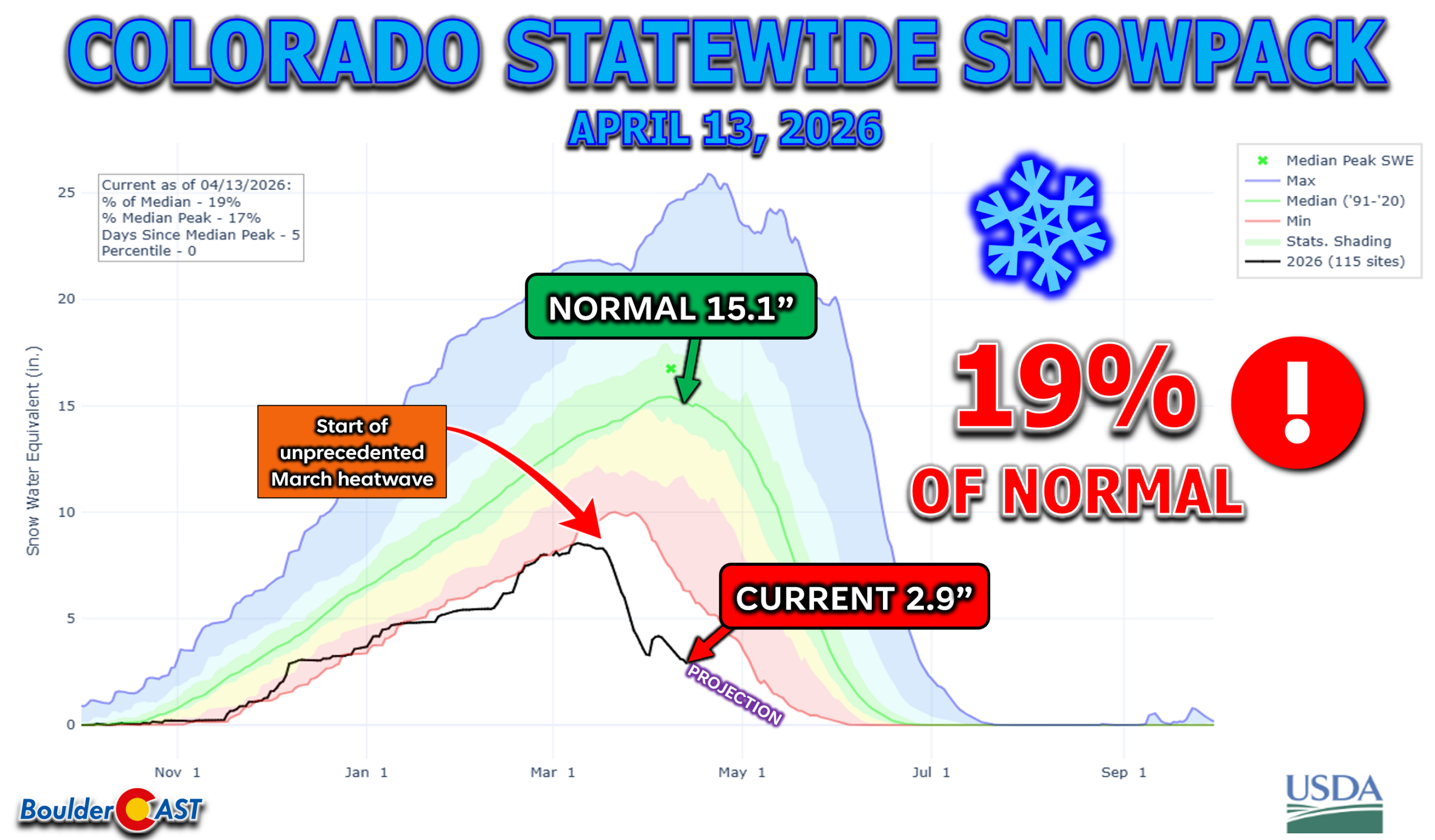
Colorado’s drought numbers are staggering:
- 100% of the state is at least Abnormally Dry
- 95% of Colorado is in drought
- 47% of Colorado is in Extreme or Exceptional levels of drought (highest since the week of the Marshall Fire in December 2021)
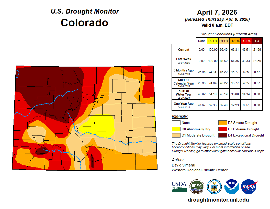
The expansion and intensification of drought statewide over the last six months is remarkable, fueled by huge evapo-precipitation deficits through the winter and early spring where below normal precipitation and wildly above normal temperatures dominated.
Though there is some rain and snow on the way this week, we’re not going to get much help in the medium-to-long-term either. Persistent ridging over the Southwest and West will favor below normal precipitation and above normal temperatures through June. Meaningful snowpack and drought recovery are off the table for the foreseeable future. Soil moisture will continue to decline and fuels will continue to dry out.
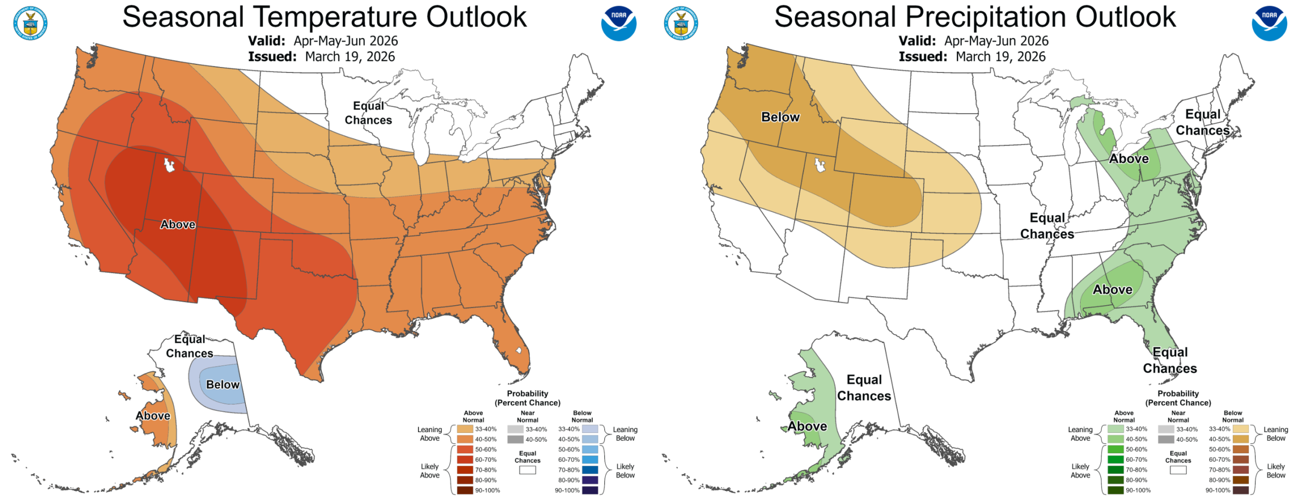
Seasonal temperature (left) and precipitation (right) outlook for April through June | NOAA Climate Prediction Center
This is the important backdrop we carry into the summer season ahead.
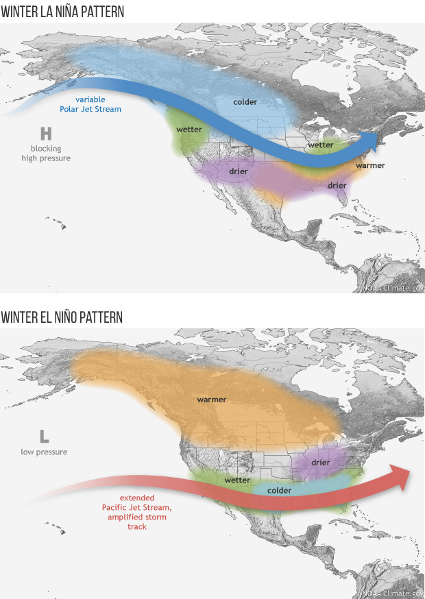
How El Niño Typically Shapes Colorado Summers
Here’s the good news. El Niño summers are often cooler and wetter across the West, including here in Colorado, so we could be in-store for a pattern flip. This is because warmer equatorial Pacific waters tend to strengthen the subtropical jet, enhance moisture transport into the Southwest, and increase the frequency of monsoon surges up from the Gulf of California, at times further enhanced by more frequent and stronger tropical cyclones in the eastern Pacific. Even a modest El Niño often improves the reliability of mid‑summer moisture, and a stronger event can amplify storm coverage and duration across Colorado, Utah and Wyoming.
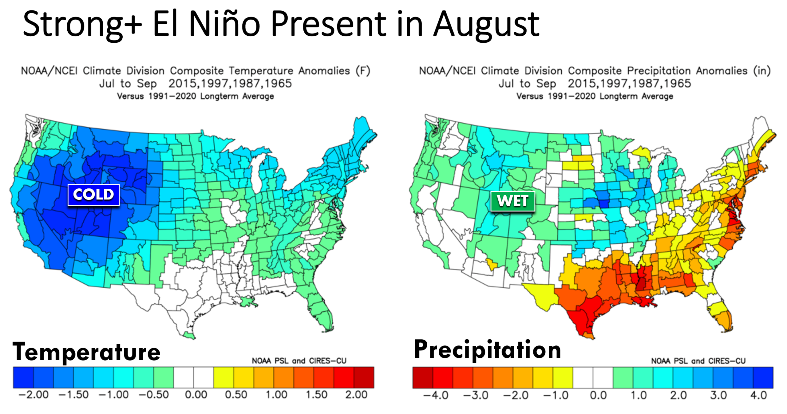
Historical composites of 16 El Niño summers show cooler temperatures across much of the country and wetter pockets across the Rockies. A stronger, more northward reaching monsoon signal is common.
If El Niño strengthens quickly, reaching into the Strong category by August like the famed European model is predicting, the odds of a robust monsoon increase further.
A similar signal is noted when considering only summers where a weak La Niña the prior winter was transitioning to a Strong+ El Niño for the upcoming winter (i.e. the situation we find ourselves in right now). Take these composites below with a grain of salt, though, as this situation only has three analogs.
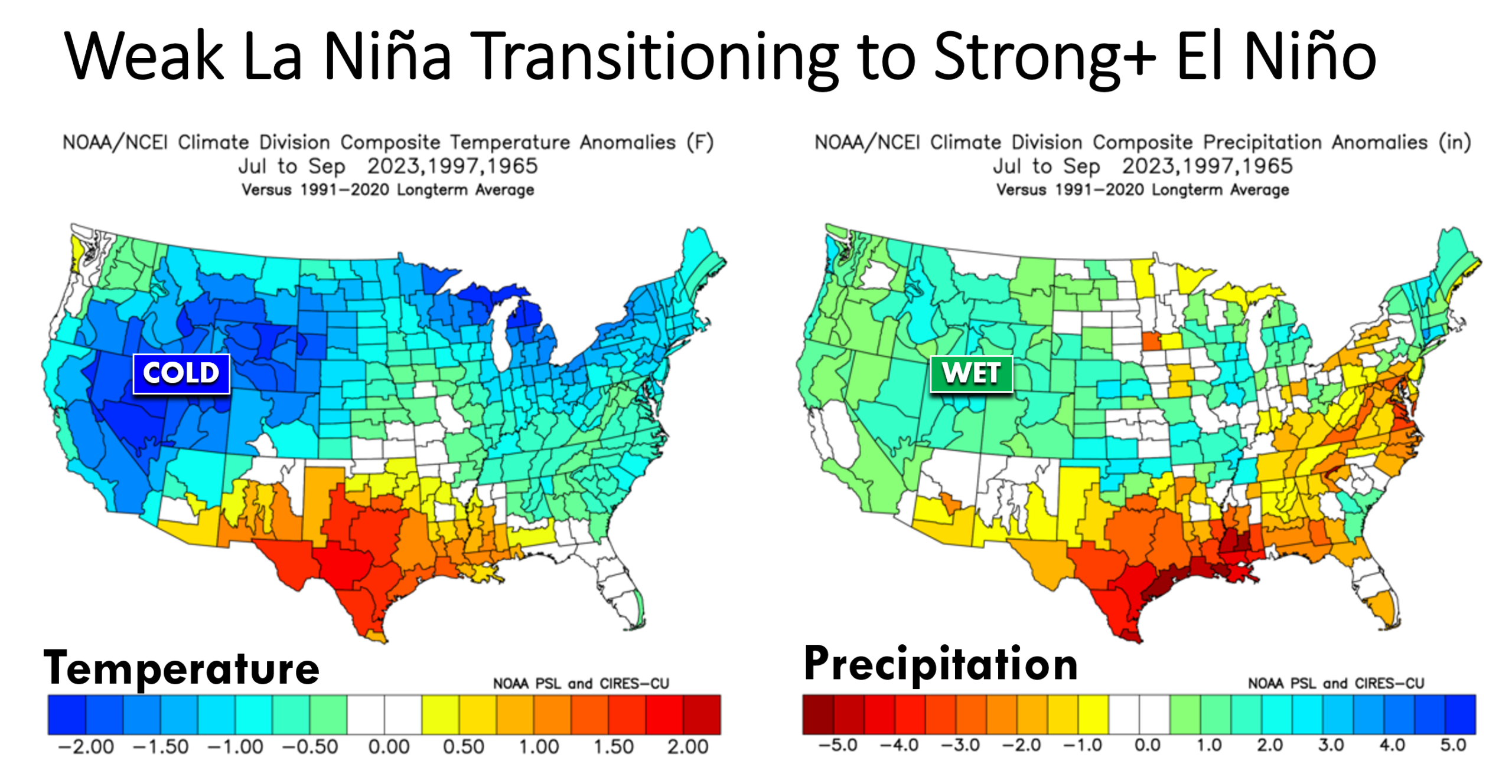
Let’s focus now more locally to the Front Range and Boulder.
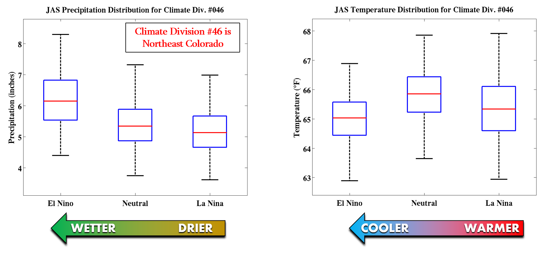
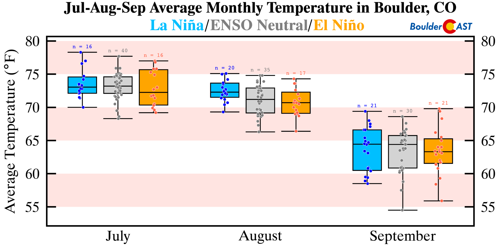
Shown below are box-and-whisker plots of precipitation (left) and temperature (right) for Climate Division #46 during the various phases of ENSO for the months of July, August and September (JAS). This is essentially the region comprising northeast Colorado and also some of north-central Colorado. A clear trend is evident from wetter and cooler conditions during El Niño towards warmer and drier conditions during La Niña, with ENSO-Neutral conditions landing somewhere in the middle. The sooner El Niño develops this summer, the better off we’ll be for monsoon rainfall here in northern Colorado.
If we look at the historical data just for Boulder, we see the same trend in summer-time precipitation. July and August (peak monsoon months) are notably drier during La Niña compared to El Niño, though that trend reverses in September. Apologies….this precipitation graphic is a bit harder to read due to a single extreme data point. Yes, we’re referencing the 18 inches of rain that fell in Boulder during the 2013 Flood (which was an ENSO-Neutral September)!
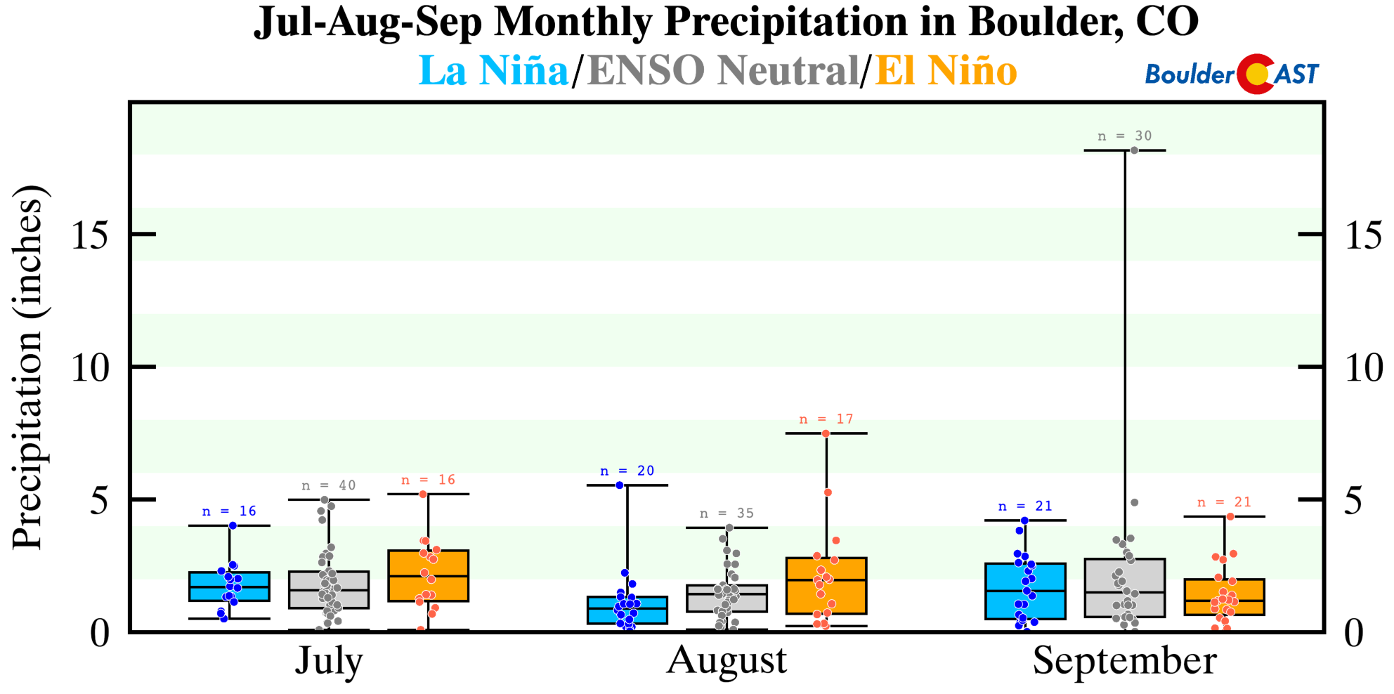
Boulder’s median precipitation amounts in JAS increase nearly 40% during El Niño compared to La Niña:
- La Niña: 4.1″
- ENSO-Neutral: 4.5″
- El Niño: 5.7″
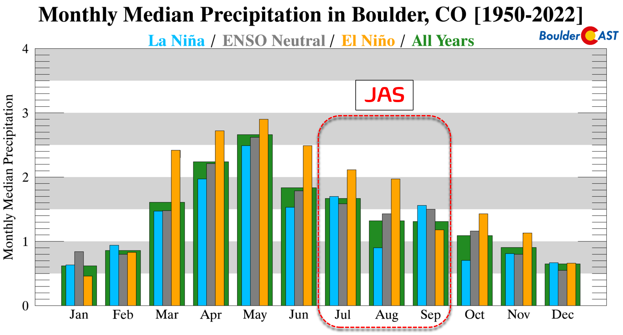
Switching gears over to temperatures, we note the same trend in Boulder that we saw earlier for all of northeast Colorado and the broader West. More frequent monsoon clouds and thundershowers during El Niño lead to tempered summer afternoons across the High Plains of eastern Colorado. El Niño summers are notably cooler by 2 to 3°F overall in Boulder compared to La Niña.
A Better Monsoon, But There’s a Catch
All signs point to a developing El Niño supercharging this summer’s monsoon across much of the West, at least in some capacity.
But before the beneficial rains arrive, there’s a well‑known and dangerous catch.
The onset of the monsoon is often dominated by dry lightning, and that’s when lightning‑caused wildfires spike. Early‑season storms routinely produce prolific cloud‑to‑ground lightning while dropping very little rain, especially when the lower atmosphere is still bone‑dry. These “dry thunderstorms” are a hallmark of the Southwest and account for a large share of the region’s annual wildfire ignitions.
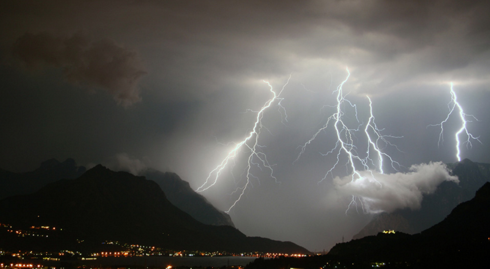
This risk is magnified this year because lightning ignition efficiency rises sharply under drought‑stressed conditions, and there is no shortage of drought across the West right now. When fuels are critically dry, even a single lightning strike can start a fire.
Drought depletes both live fuel moisture (shrubs, trees, grasses) and dead fuel moisture (branches, litter, fine fuels). When both are critically low, the odds of a persistent ignition from lightning rise dramatically.
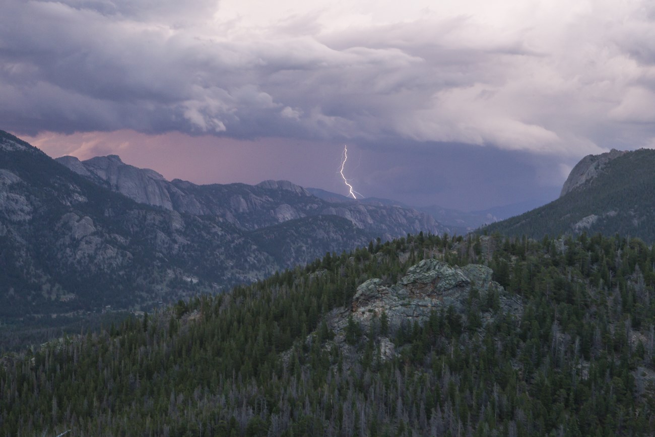
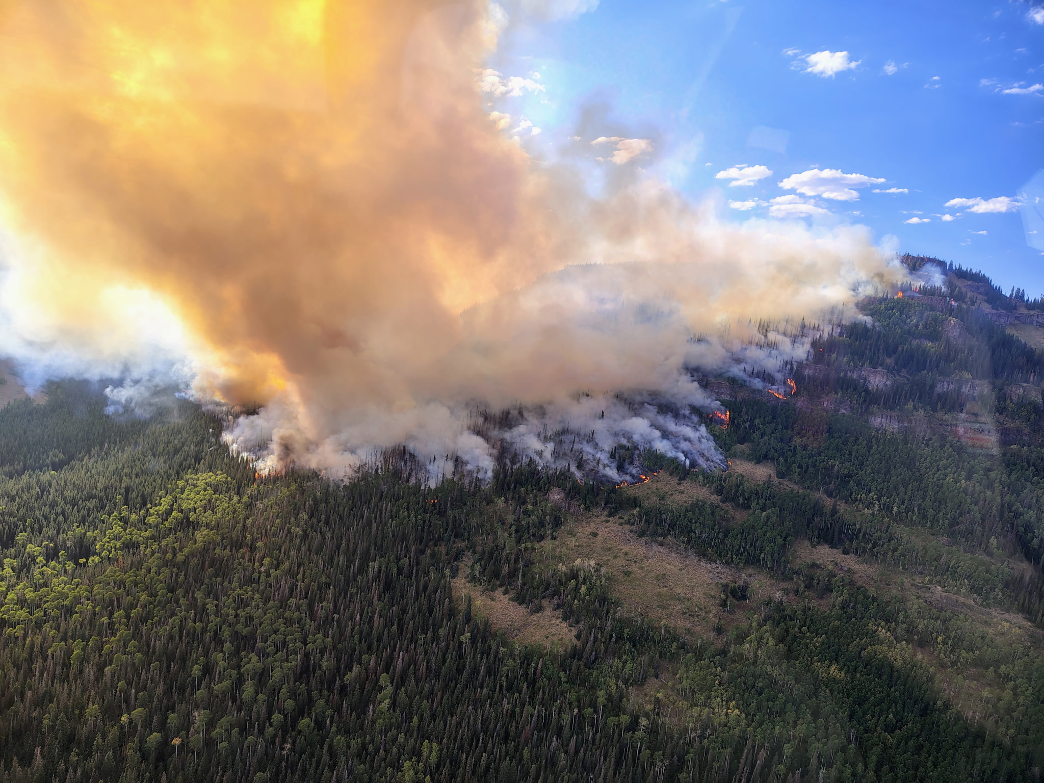
Boulder County knows this all too well. June 26th, 2012 is etched into local memory: Extreme Drought following a record dry spring, temperatures pushing 100° for the fifth straight day, and a early-summer dry thunderstorm that sparked the Flagstaff Fire. It ultimately burned ~300 acres, including portions of Bear and South Boulder Peaks.
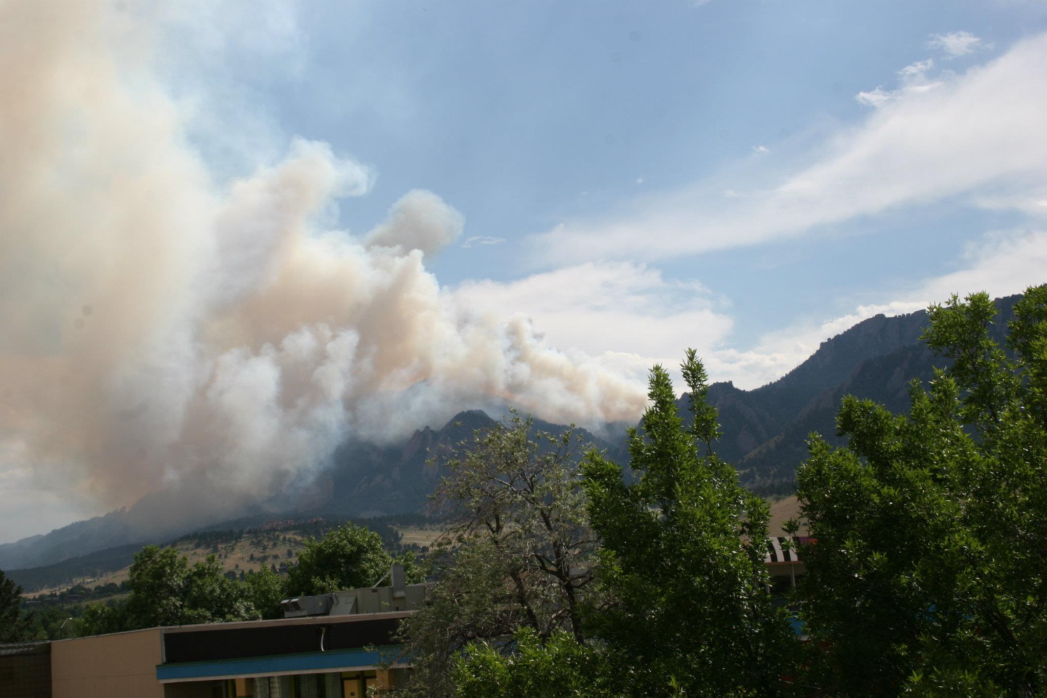
Picture taken 6/26/2012 of the Flagstaff Fire burning southwest of Boulder, sparked just an hour or two prior by dry lightning.
Less remembered—but just as telling—was another ignition two days later, on June 28th, when a largely dry storm sparked a spot fire near the summit of Green Mountain west of Boulder. Air support knocked it down quickly, but the setup was identical: drought, heat, and lightning with almost no rain.
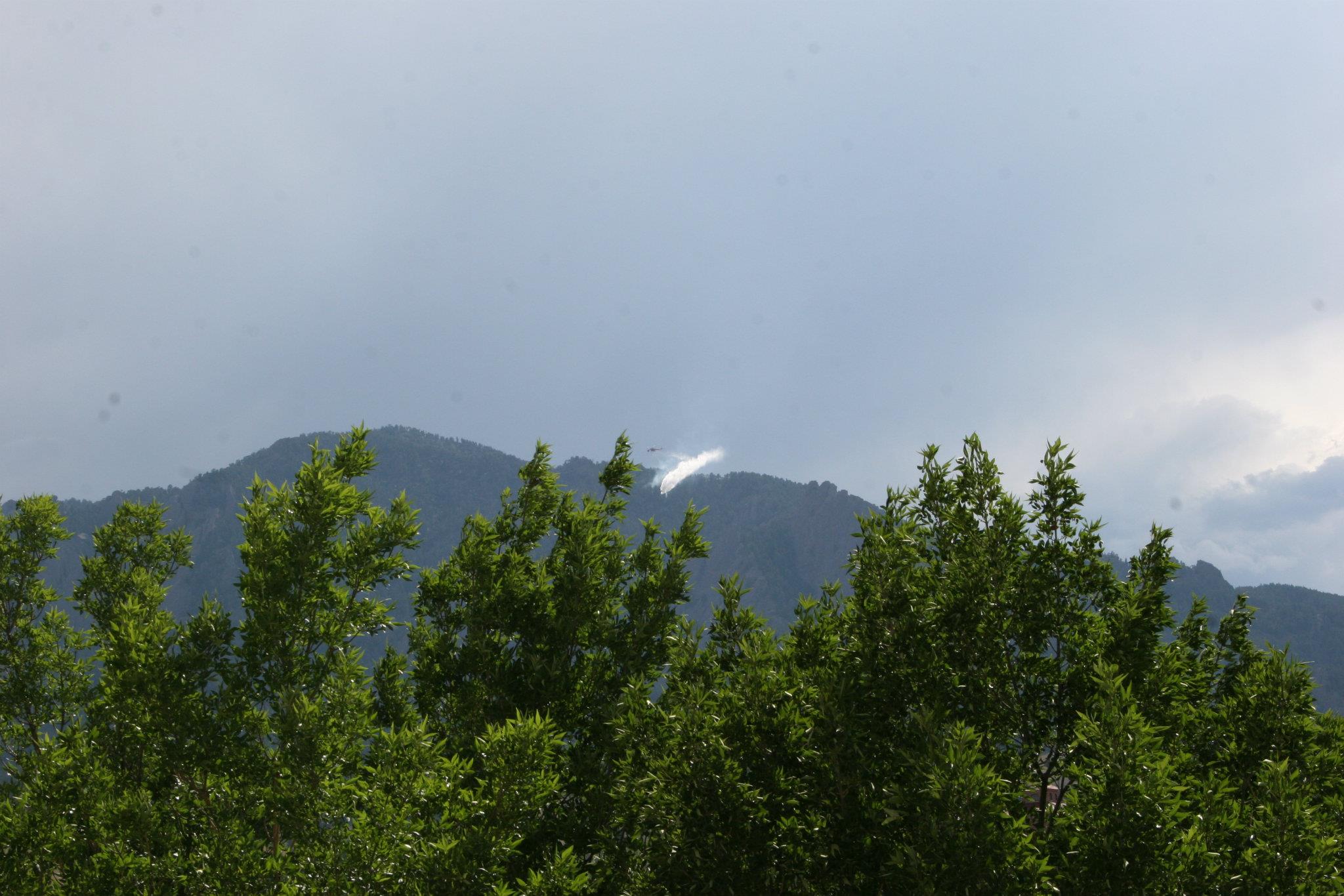
Picture taken 6/28/2012 of a helicopter dropping water on a small fire sparked on Green Mountain above the Flatirons.
Fuel moisture remains the single most important factor in whether a lightning strike becomes a wildfire. And Colorado’s fuels are drier now in spots than they were in 2012 and this is only expected to worsen heading into early summer.
Across most of the West, the landscape is already primed to burn. Snowpack is at historic lows. Soil moisture is deeply depleted and fuels have cured weeks to months ahead of schedule.
When the first monsoon surges arrive, they will almost certainly bring lightning long before they bring meaningful rainfall. That combination sets the stage for a high‑impact early‑season fire risk Westwide, even if the monsoon eventually turns wetter and more beneficial later in the summer thanks to El Niño (which is common). Now is the time to make sure your home and family are prepared for a likely hyperactive summer fire (and smoke) season in the West.
Conclusion: A Summer of High Stakes in Colorado
El Niño is coming, but the “Super El Niño” narrative is premature and overblown. It’s built on a single model that often skews too warm when initialized in April. The real story is more nuanced. A developing El Niño should help supercharge Colorado’s monsoon, but not before we navigate a dangerous early‑summer window filled with extreme drought, hot temperatures, and high lightning‑ignition potential.
Looking beyond summer, the developing El Niño at least gives us something we haven’t had much of lately: a legitimate reason to hope. After several years dominated by La Niña’s stubborn influence — and the dry, erratic storm tracks that came with it — the shift toward El Niño represents a meaningful pattern change for Colorado. Historically, El Niño winters tend to steer more favorable storm tracks across the southern Rockies, improving the odds for healthier snowpack in several of Colorado’s mountain ranges and offering the Boulder and Denver more frequent opportunities for upslope moisture.
None of this is guaranteed, of course. We’re still navigating the ENSO spring predictability barrier with the outlook for winter much less certain than the summer ahead. Even with that uncertainty, the broader global setup is at least opening the door for a different pattern — one capable of delivering the kind of statewide recovery that felt far out of reach this past winter.
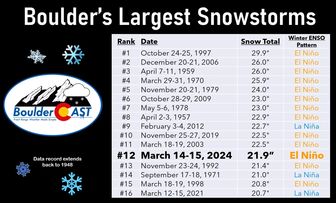
13 out of 16 of Boulder’s largest snowstorms since 1950 have occurred during El Niño (or warm anomaly leaning) winters
But realistically, any outcome next winter would be an improvement over what we just endured across the West. After a season defined by persistent warmth, meager snowpack, and a storm track that rarely cooperated, simply returning to something closer to “normal” would feel like a step forward. El Niño doesn’t promise a fix, but it does offer a pathway to improvement. That alone is more than we’ve had in quite some time.
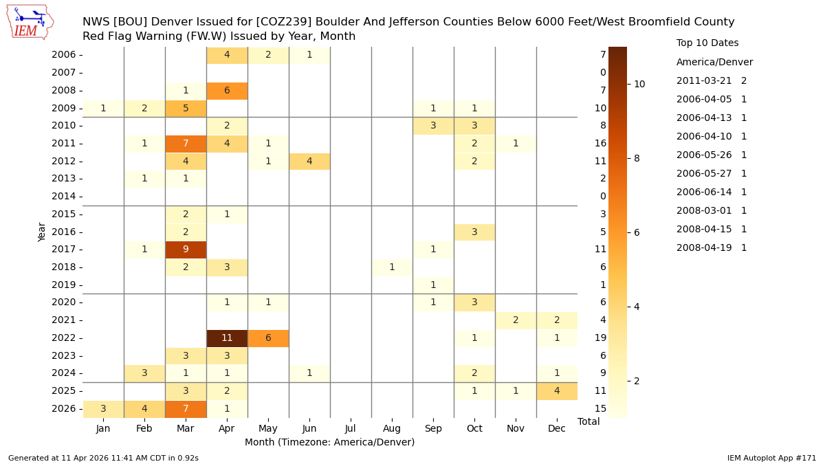
Only 3.5 months in, Boulder has already had 15 Red Flag days in 2026, well past the average for an entire calendar year.
For now, we take the cautious optimism where we can find it. Relief may eventually come later in 2026, but we have a long, tense stretch of spring and summer laced with exceptional fire risk and smoke-laden air to get through first.
Spread the word, share our crazy Colorado weather:
Go Premium, get all the perks.
Daily Forecast Updates
Get our daily forecast discussion every morning delivered to your inbox.
All Our Model Data
Access to all our Colorado-centric high-resolution weather model graphics. Seriously — every one!
Ski & Hiking Forecasts
6-day forecasts for all the Colorado ski resorts, plus more than 120 hiking trails, including every 14er.
Smoke Forecasts
Wildfire smoke concentration predictions up to 72 hours into the future.
Exclusive Content
Weekend outlooks every Thursday, bonus storm updates, historical data and much more!
No Advertisements
Enjoy ad-free viewing on the entire site.


Can you please make it easier to log in? Thanks.
On mobile, it’s Hamburger button > Login. Or scroll all the way to the bottom of the page to Login panel.
On tablet or desktop PC, login is at the top of the right-hand sidebar in the Login panel.