As we roll into mid‑April, the Front Range finally snaps back into an active pattern with fire danger, two storm systems, and even a shot at late‑season snow all packed into one busy week. From warm, windy days to Mountain snow and the possibility of flakes reaching the Denver–Boulder corridor by Friday, there’s a lot happening in the days ahead. Read on for all the details.
This week’s highlights include:
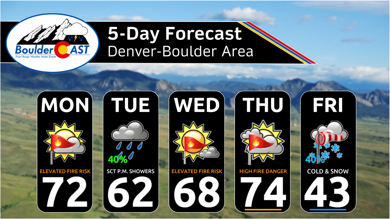
- 🔥 Near‑critical fire danger Monday with 8–15% humidity and 15–30 MPH winds across eastern Colorado.
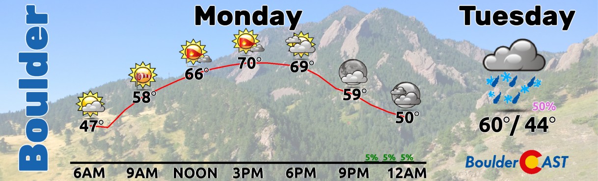
- 🌞 Monday stays warm and pleasant, topping out in the lower 70s despite elevated fire weather.
- 🌨️ System #1 arrives Tuesday, bringing Mountain snow and scattered rain showers for the Metro area.
- 🏔️ High snow levels near 9000 feet keep winter impacts minor, with 3–8 inches of wet snow above treeline.
- 💨 Fire danger returns Wednesday and Thursday as a ridge brings dry air and 20–30 MPH gusts.
- 🌡️ Thursday spikes to the mid‑70s to near 80, likely the warmest day of the week before a strong cold front arrives.
- ❄️ System #2 targets Friday, a colder Canadian trough with potential for accumulating wet snow at ALL elevations.
- 🧊 Friday night freeze likely, with lows in the 20s for the Plains and teens in the Foothills. Another freeze may occur Saturday night.
DISCLAIMER: This weekly outlook forecast is created Monday morning and covers the entire upcoming week. Accuracy will decrease as the week progresses as this post is NOT updated. To receive daily updated forecasts from our team, among many other perks, subscribe to BoulderCAST Premium.

Go Premium, get all the perks.
Daily Forecast Updates
Get our daily forecast discussion every morning delivered to your inbox.
All Our Model Data
Access to all our Colorado-centric high-resolution weather model graphics. Seriously — every one!
Ski & Hiking Forecasts
6-day forecasts for all the Colorado ski resorts, plus more than 120 hiking trails, including every 14er.
Smoke Forecasts
Wildfire smoke concentration predictions up to 72 hours into the future.
Exclusive Content
Weekend outlooks every Thursday, bonus storm updates, historical data and much more!
No Advertisements
Enjoy ad-free viewing on the entire site.
Two Systems to Watch This Week
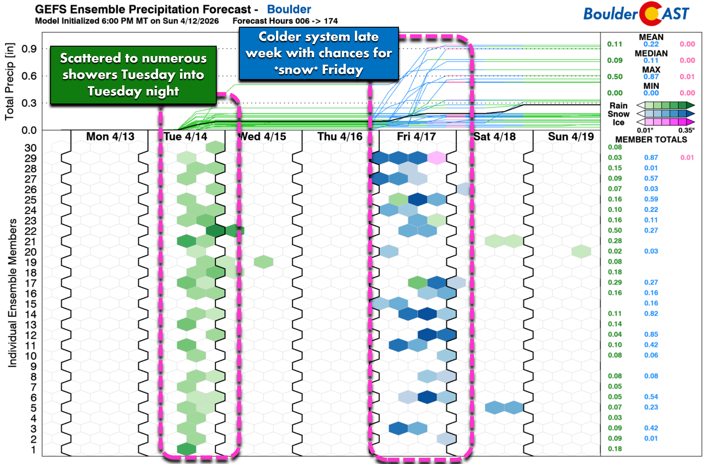
Mid-April brings a more active pattern to the Front Range with two storm systems lined up to influence our weather. The first is a weakening trough that contains the remnants of a warm cut-off low from California. It will move across Colorado Tuesday into early Wednesday and produce Mountain snow along with scattered showers for the lower elevations.
The second system is colder and stronger. It will drop out of western Canada late in the week and carries the potential for snow at all elevations, including Boulder and Denver.
More Fire Danger on Monday
Before the storms arrive, Monday brings another round of near-critical fire weather across eastern Colorado. Humidity will fall to 8–15% during the afternoon while southwest winds gust 15–30 MPH. As we saw Sunday, localized terrain circulations may again limit gusts in parts of Denver, although areas north and south of the city should see several hours with 25 MPH gusts or better.
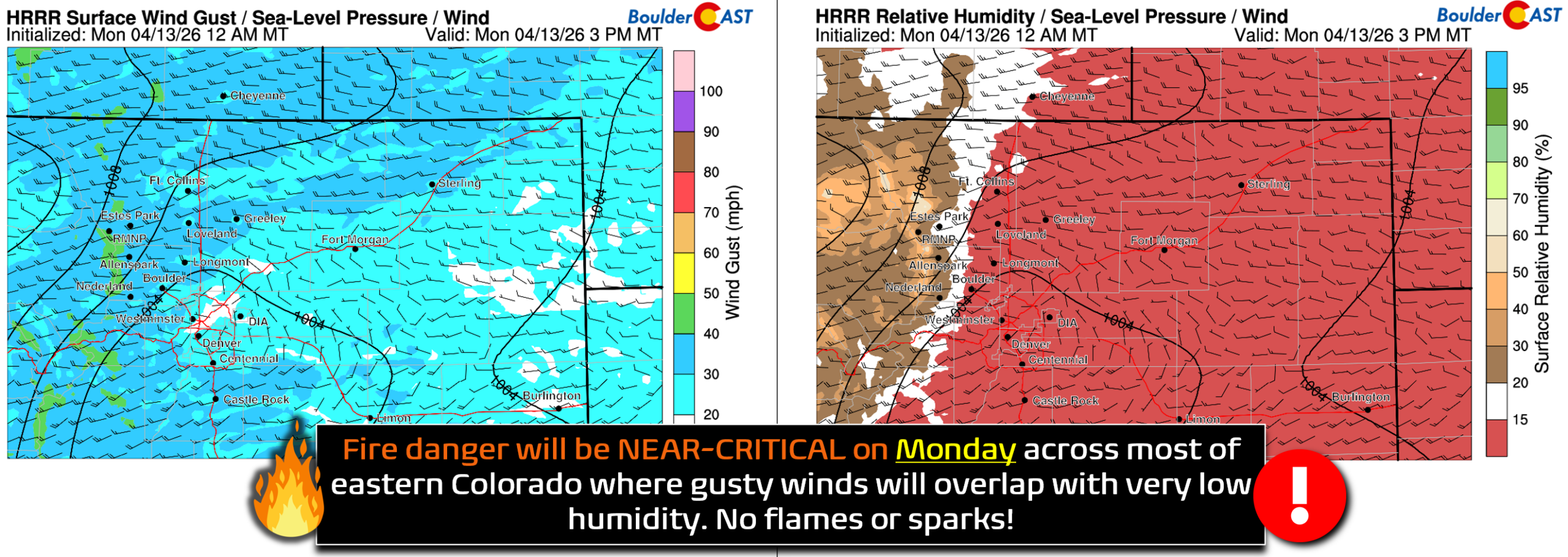
Boulder and Denver are not included in the Red Flag Warnings on Monday, but conditions will still be elevated to near-critical. Fuels remain dry and any ignition could spread quickly. No flames or sparks!
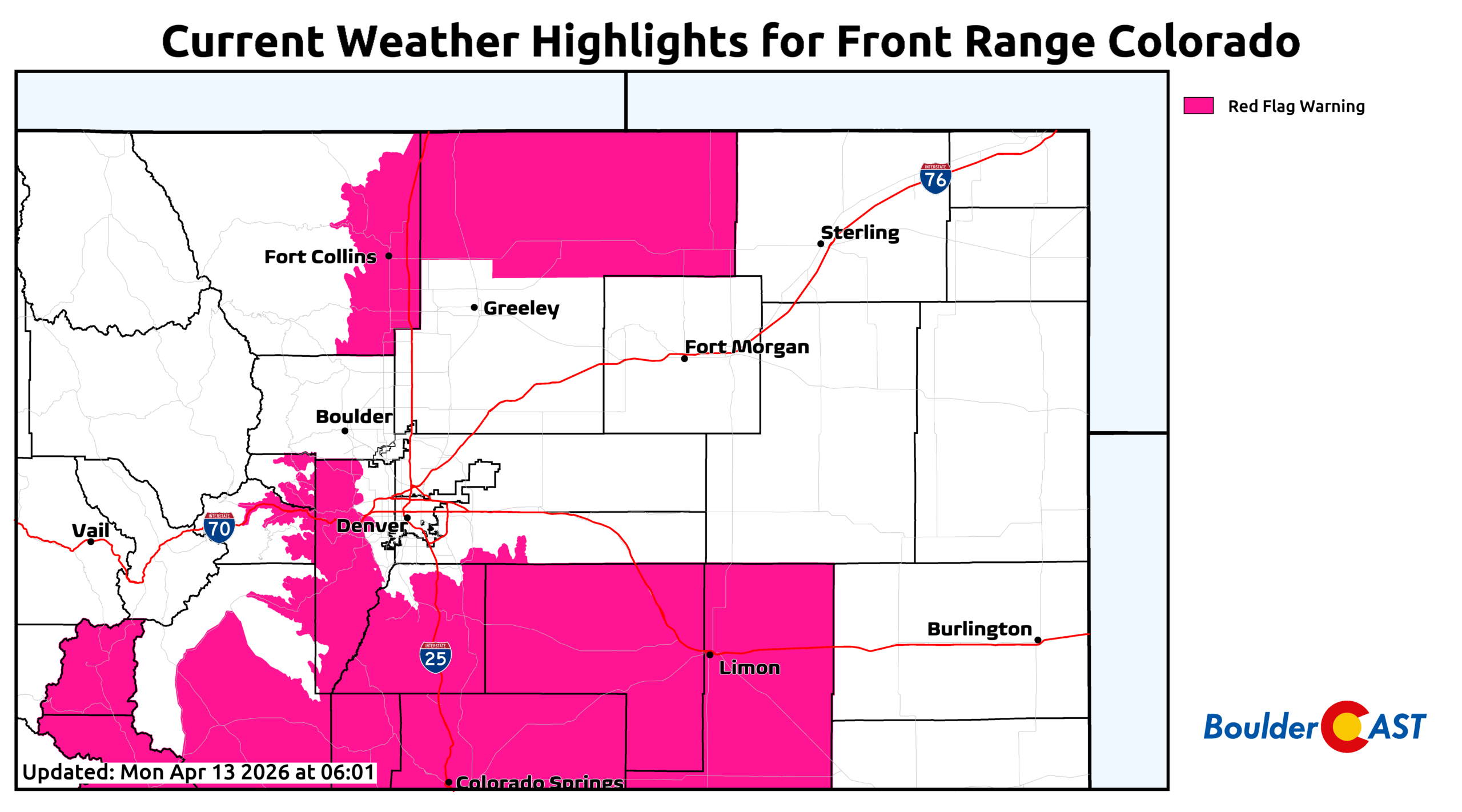
Aside from the fire danger, Monday will be pleasant with partly sunny skies and highs in the lower to middle 70s.
System #1: Tuesday into Early Wednesday
Rain Showers & Mountain Snow
The first system arrives as Monday’s cut‑off low moves through Las Vegas and into Utah, reaching the Salt Lake City area by Tuesday morning. As it crosses the Rockies, the low will open up into a more progressive wave — a structural change that ultimately will limit upslope and therefore precipitation potential for our area.
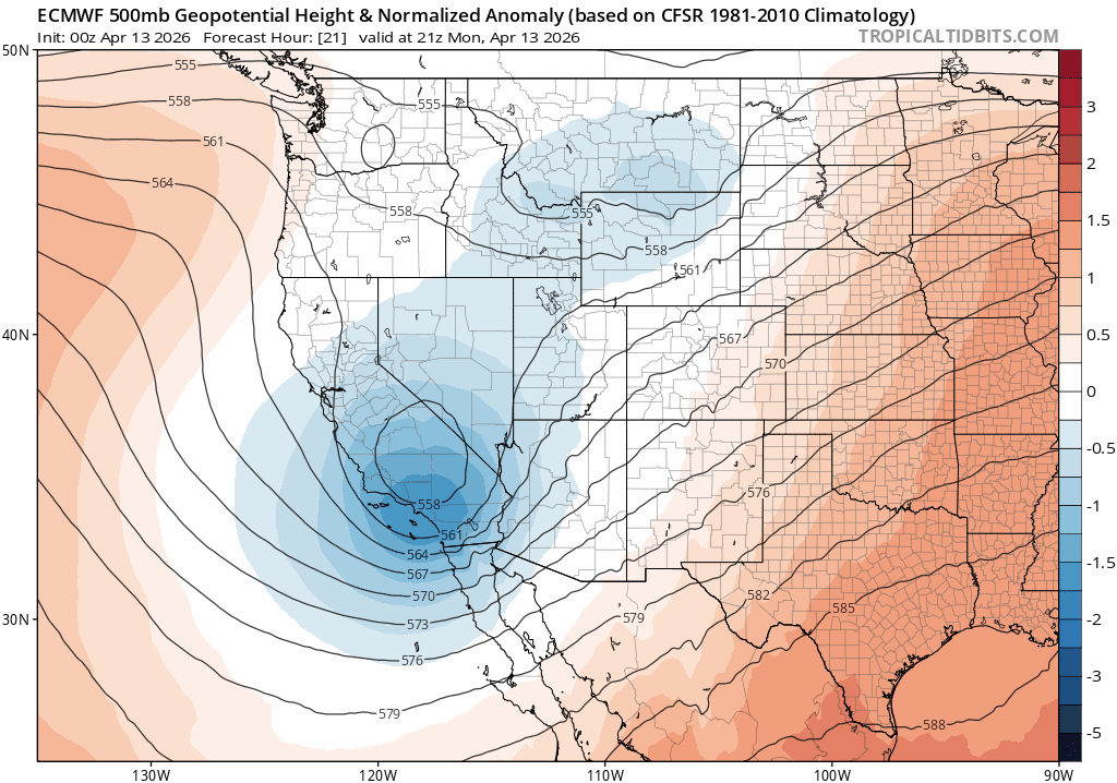
Euro model 500mb heigh anomaly forecast animation for Monday into Wednesday showing the first storm system passing through Colorado.
Even so, the track is favorable enough for northern Colorado to see impacts:
- Mountain snow begins late Monday night or early Tuesday.
- A cold front pushes into the Denver–Boulder area Tuesday afternoon, helping trigger scattered rain showers, mainly north of I‑70.
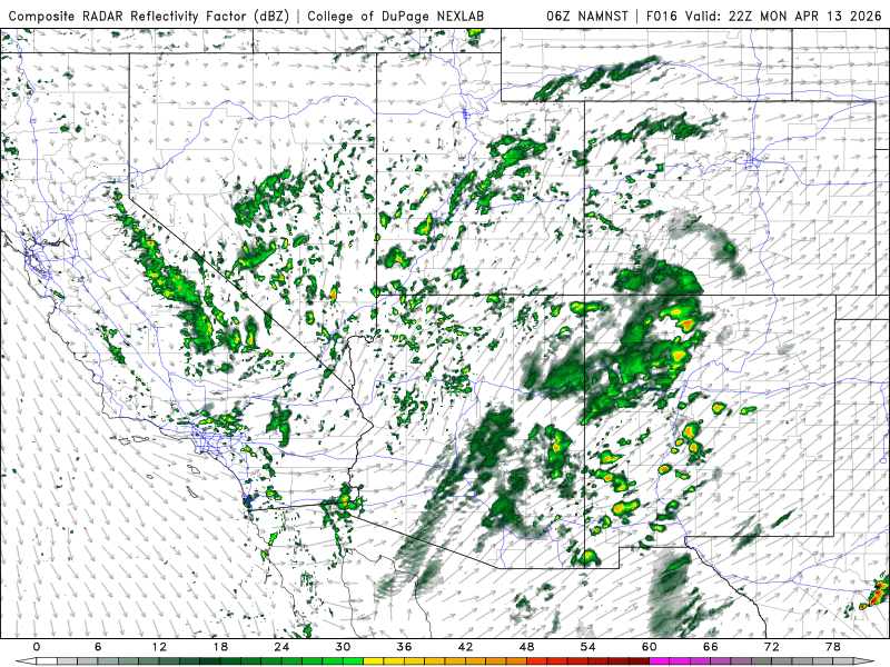
Model simulated radar for Monday night into Wednesday morning showing the first system passing and precip potential
The most coherent band of precipitation will stretch from northern Colorado into southeast Wyoming and Nebraska, where the trough dynamics are strongest.
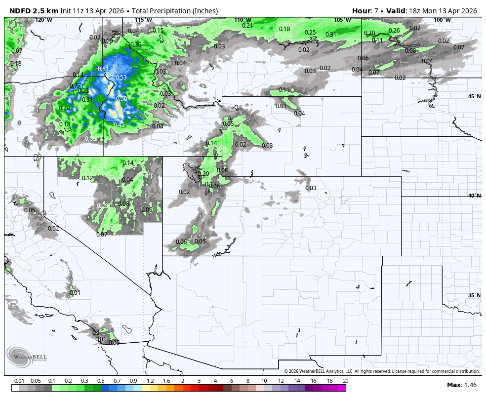
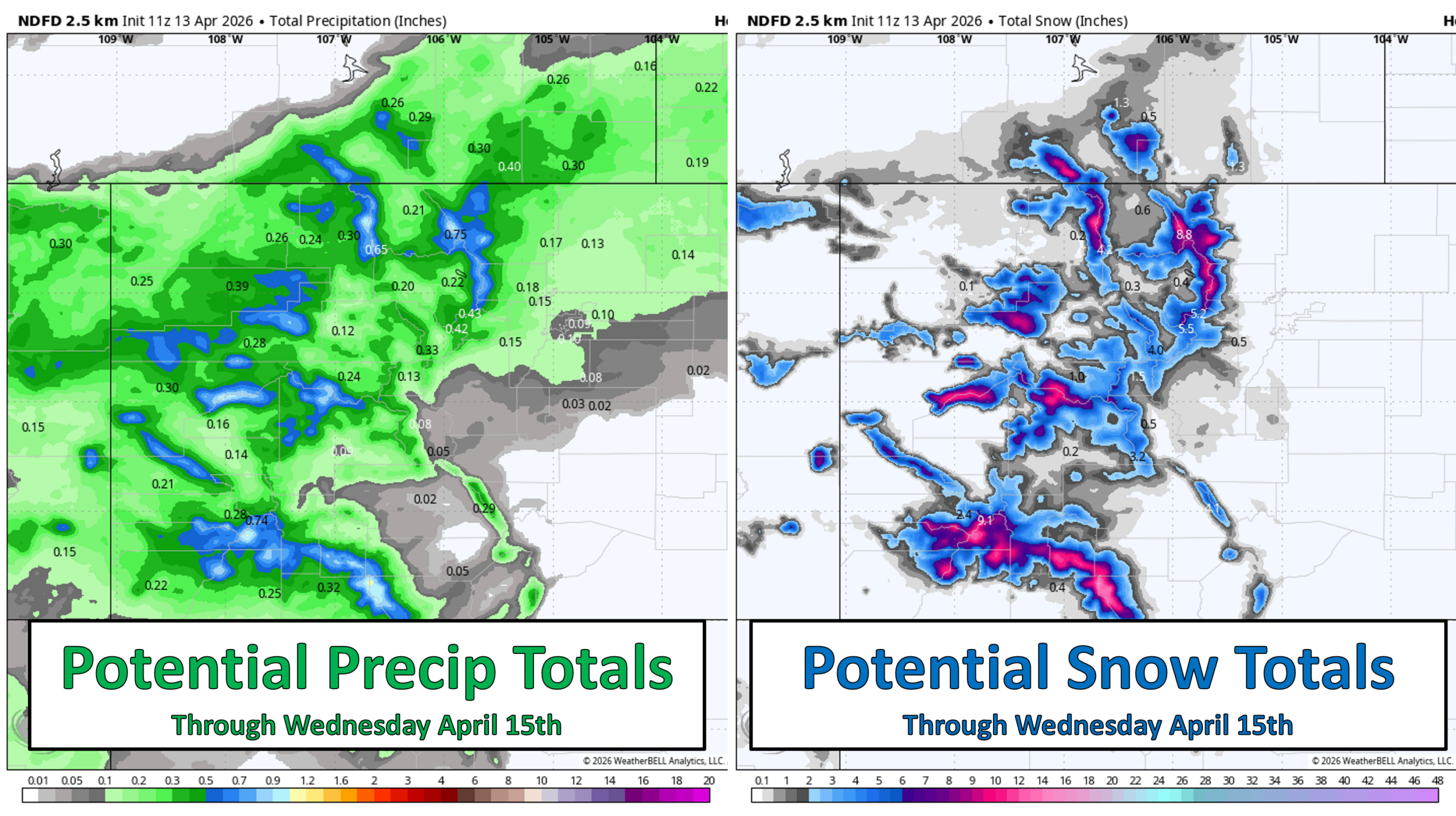
Moisture is limited, so rainfall totals will be modest: generally under 0.15″, even for the luckiest spots. Snow levels remain high — around 9,000 feet — thanks to the system’s warm California origins. Above treeline, 3 to 8 inches of wet snow is possible, with only minor travel impacts on the passes. Showers, both rain and snow, will taper off Tuesday evening and night.
More fire danger Wednesday & Thursday
A brief ridge will build overhead Wednesday, quickly drying the atmosphere. Afternoon humidity drops again while 20–30 MPH gusts return. It’s still uncertain whether humidity will fall low enough for critical fire weather, but elevated conditions appear likely for at least parts of the Front Range. Temperatures will rebound into the mid to upper 60s under mostly sunny skies.
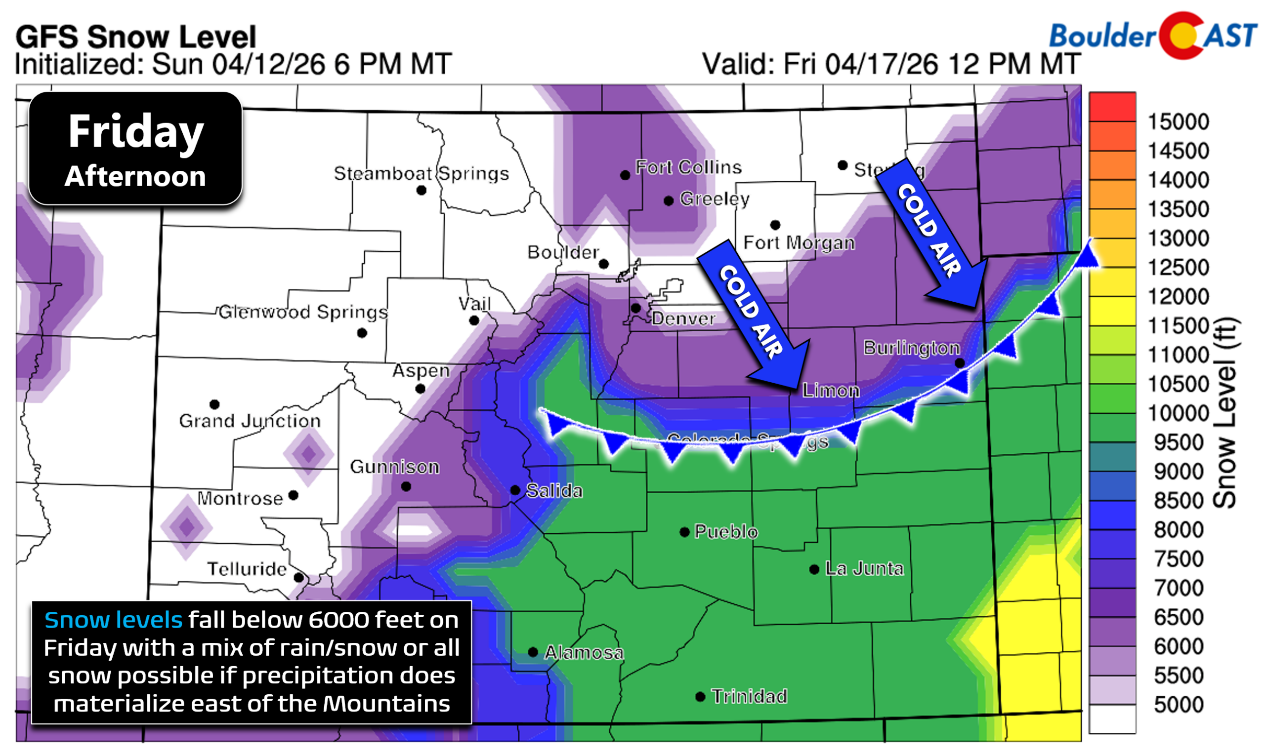
System #2: A Colder Storm Arrives Friday
Snow Possible for Everyone
Confidence is increasing that a colder, more dynamic system will dig into the northern Rockies late this week. This storm will tap into air from western Canada, giving it a much colder profile than Tuesday’s system. However, the track and timing remain highly uncertain — and those details will determine whether the Front Range sees a glancing blow or a meaningful spring snow.
At this point, several outcomes remain on the table:
- A near‑miss to the north, with only light rain/snow or flurries, and some wind.
- A direct hit, bringing a few inches of wet accumulation to Boulder, Denver, and the western/southern suburbs. Great accumulation potential in the Foothills.
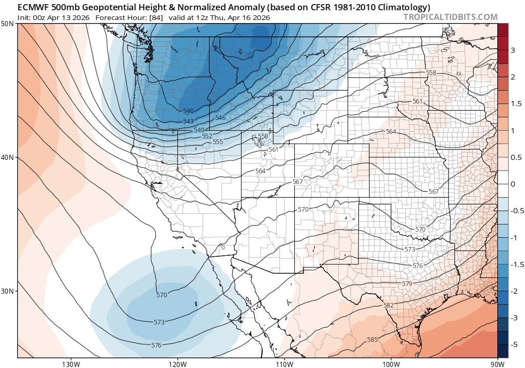
Euro model 500mb heigh anomaly forecast animation for Thursday into Saturday morning showing the second storm system passing through Colorado.
If precipitation does materialize Friday — which is more likely than not — temperatures should be cold enough for snowflakes all the way down into Boulder and Denver. It’s been nearly a month since our last accumulating snow (March 16), but this system could very well break that streak.
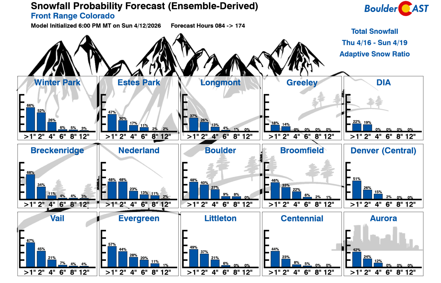
Potential snowfall amounts don’t look to be all that impressive thanks to the fast-moving nature of the late-week trough, though Boulder and the Foothill‑adjacent suburbs currently hold a 20%+ chance of topping 4 inches according to our latest Snowfall Probabilities.
Ahead of the storm, Thursday looks warm, windy, and dry:
- Highs in the mid‑70s to near 80°F — the warmest day of the week.
- Strong southwest winds, likely prompting Red Flag Warnings for much of eastern Colorado.
A preliminary cold front arrives Thursday night, followed by a stronger secondary front Friday. Any snow would likely begin behind the second front sometime Friday.
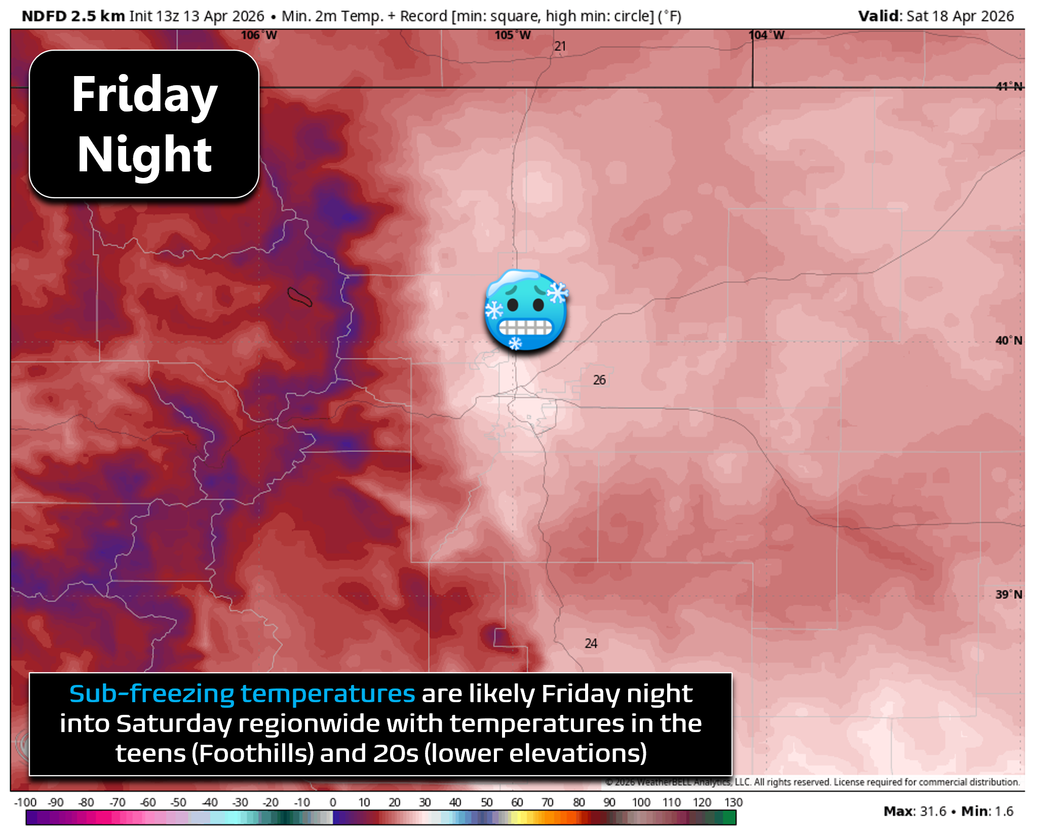
Friday night temperatures will drop below freezing area-wide, likely landing somewhere in the 20s across the lower elevations and in the teens in the Foothills. If you have already activated your irrigation systems, above ground piping (like backflows) should be drained as a precaution once we get closer. Temperatures may fall below freezing again Saturday night as well.
Bottom Line
This is shaping up to be the most active week of weather the Front Range has seen in quite some time — a mix of fire danger, two storm systems, and the strong potential for late‑week snow and hard freezes. We’ll be refining the Friday storm details as confidence improves through the week so stay tuned. More updates to come as the pattern evolves…
Forecast Specifics:
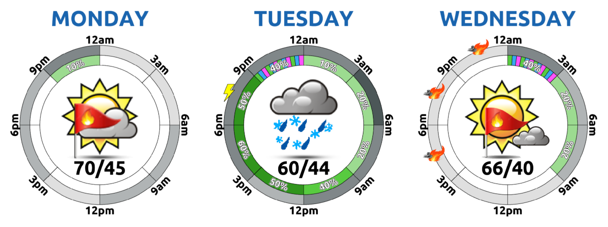
Monday: Mostly sunny and breezy with elevated fire danger. Gusts of 15 to 25 MPH during the day. Highs reach the lower 70s on the Plains with lower 60s in the Foothills.
Tuesday: Overcast and cool with highs around 60 degrees on the Plains and in the middle 40s in the Foothills. Scattered rain showers will be possible from late-morning into the evening, with snow in the higher Foothills. Less than 1 inch of accumulation expected.
Wednesday: Sunshine returns with afternoon breezes elevating fire danger somewhat. High warm back into the upper 60s on the Plains with middle 50s in the Foothills.
Thursday: Gusty and warm with highs in the mid to upper 70s on the Plains and middle 60s in the Foothills. Fire danger will be high regionwide with Red Flag Warnings likely.
Friday: Much colder with increasing clouds. Wet snow will increase behind a strong cold front during the day, lingering into the evening or overnight. Accumulation is favored for most of the area, with the Foothills set to receive the most. Highs much colder in the lower 40s or even 30s, depending on the frontal timing. Overnight lows will drop into the 20s Friday night with a hard freeze on the table.
DISCLAIMER: This weekly outlook forecast is created Monday morning and covers the entire upcoming week. Accuracy will decrease as the week progresses as this post is NOT updated. To receive daily updated forecasts from our team, among many other perks, subscribe to BoulderCAST Premium.
Go Premium, get all the perks.
Daily Forecast Updates
Get our daily forecast discussion every morning delivered to your inbox.
All Our Model Data
Access to all our Colorado-centric high-resolution weather model graphics. Seriously — every one!
Ski & Hiking Forecasts
6-day forecasts for all the Colorado ski resorts, plus more than 120 hiking trails, including every 14er.
Smoke Forecasts
Wildfire smoke concentration predictions up to 72 hours into the future.
Exclusive Content
Weekend outlooks every Thursday, bonus storm updates, historical data and much more!
No Advertisements
Enjoy ad-free viewing on the entire site.
Enjoy our content? Give it a share!


You must be logged in to post a comment.