After a rather quiet week with seasonal temperatures, winter weather will return to the Front Range for the third weekend in a row as colder air and a quick shot of light accumulating snow arrive Friday evening and night. We discuss the atmospheric setup about to unfold, the potential snowfall amounts across the Metro area and Foothills, as well as when travel will be most impacted.
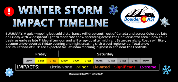
Update (Friday 2/16/24 8:00AM): We’re now seeing a better signal of stalled convergence/jet-forcing briefly sitting over the Denver area Friday evening, combined with a continued expectation for very fluffy snow ratios. Thus, we’ve bumped up snow amounts across the Metro area. Please check the updated snowfall map and storm impact timeline near the end of this post. We talk about this shift and much more in Friday morning’s Premium discussion HERE.
At a Glance
- Cold Front and Snow: A weak and dry cold front moves through Thursday evening. There will be a second mid-level disturbance later on Friday which will generate a brief period of light to moderate snowfall region-wide.
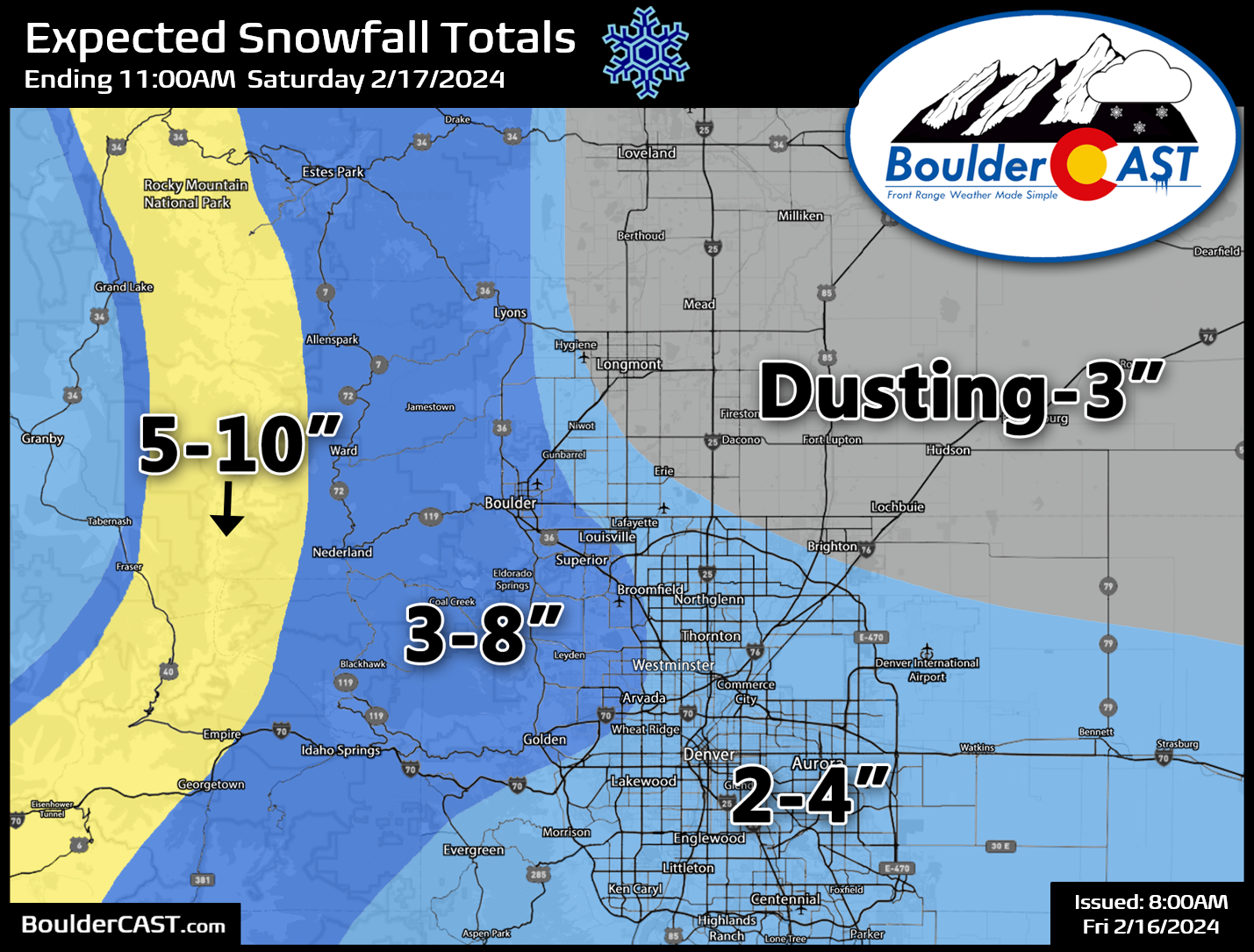
- Snowfall Forecast: Snowfall totals of a dusting to 8 inches are expected for the Denver Metro area and Foothills, with up to a foot in the Mountains.
- Travel Impacts: Watch for slick travel conditions Friday evening into early Saturday as roads will become snow-covered across much of the area.
- A Warm Extended: Quiet and warmer weather is expected for the weekend and early next week with temperatures shooting up eventually towards 60 degrees.

Go Premium, get all the perks.
Daily Forecast Updates
Get our daily forecast discussion every morning delivered to your inbox.
All Our Model Data
Access to all our Colorado-centric high-resolution weather model graphics. Seriously — every one!
Ski & Hiking Forecasts
6-day forecasts for all the Colorado ski resorts, plus more than 120 hiking trails, including every 14er.
Smoke Forecasts
Wildfire smoke concentration predictions up to 72 hours into the future.
Exclusive Content
Weekend outlooks every Thursday, bonus storm updates, historical data and much more!
No Advertisements
Enjoy ad-free viewing on the entire site.
Really, a third snowy weekend in a row?!
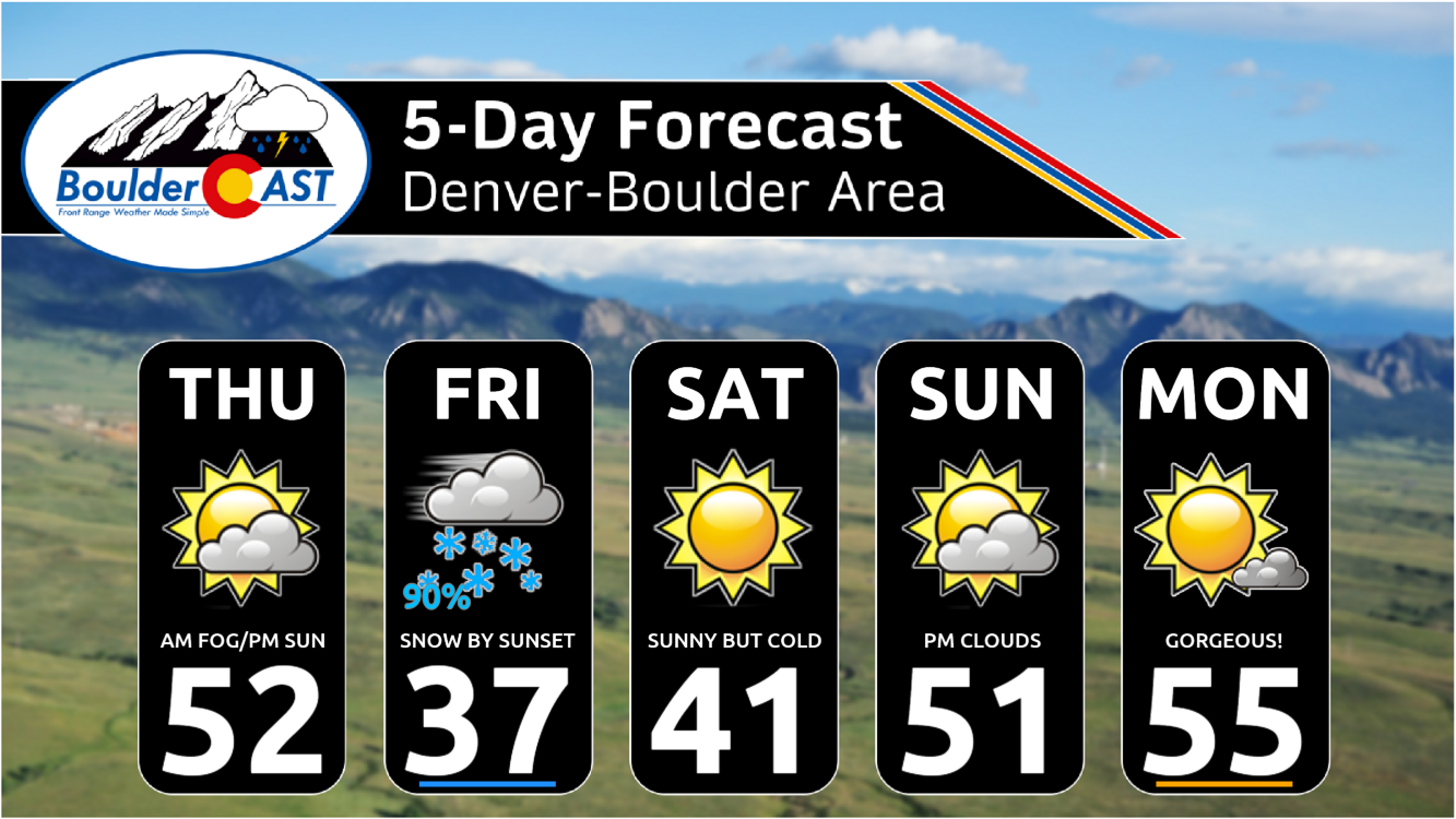
We have one more fairly seasonal day ahead before things turn colder Friday into Saturday as a “one-two-punch” wintry system drops southward out of western Canada. For Thursday, look for highs once again in the low to middle 50s — our fourth consecutive day with basically the same temperature outcome.
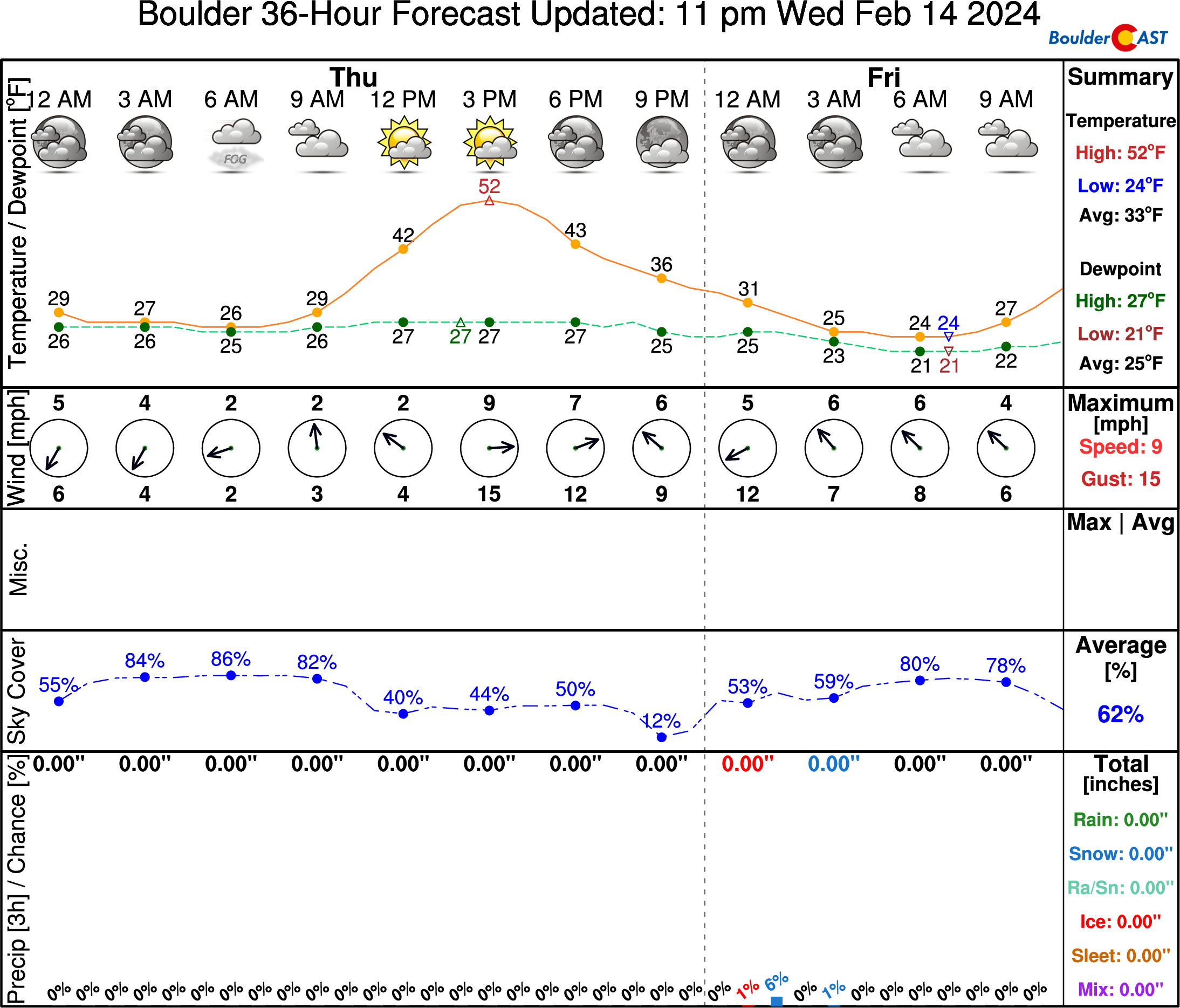
We are starting out with low clouds and shallow fog this morning, but it should burn off in a few hours’ time. A Dense Fog Advisory is currently in effect for the lower elevations. Use caution if you are out and about this morning. The fog isn’t exactly dense everywhere, but there are certainly pockets of near-zero visibility based on regional cams and observations.

Of course, if you go up about 1500 feet in elevation, the sun is shining bright this morning!
The cold front we’ve been tracking all week is still on-schedule to arrive this evening. It’s not the strongest front in the world, but it will bring a change in airmass to the Front Range with temperatures dropping perceivably as we head into our Friday.
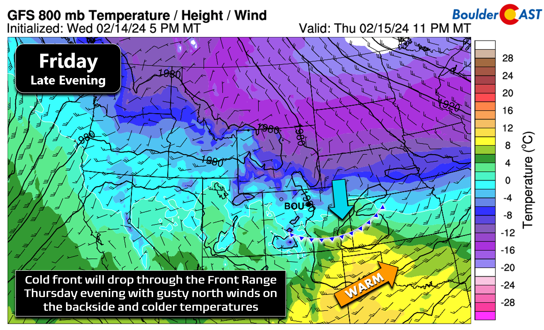
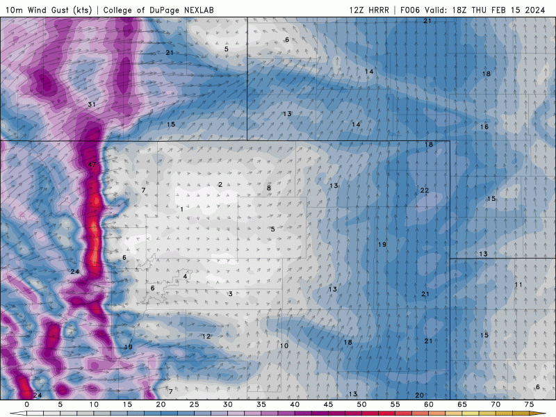
The HRRR model has the cold front blowing into the Denver Metro around 9PM Thursday evening. Initially there may be some gusty west-southwest winds across the area this afternoon into early evening (10 to 20 MPH at times). The front will usher in a blast of northerly winds as it passes and on its backside with gusts of 20 to 30 MPH. You can see the front racing through in the surface wind forecast animation below. We still believe this frontal passage will be largely dry, with just a slight chance of a few flurries or a brief snow shower late this evening into the overnight. Little to no accumulation is expected.
As mentioned earlier, with the change in airmass, Friday will end up about 15° colder with mostly cloudy skies during the day — this will put our highs only in the 30s.
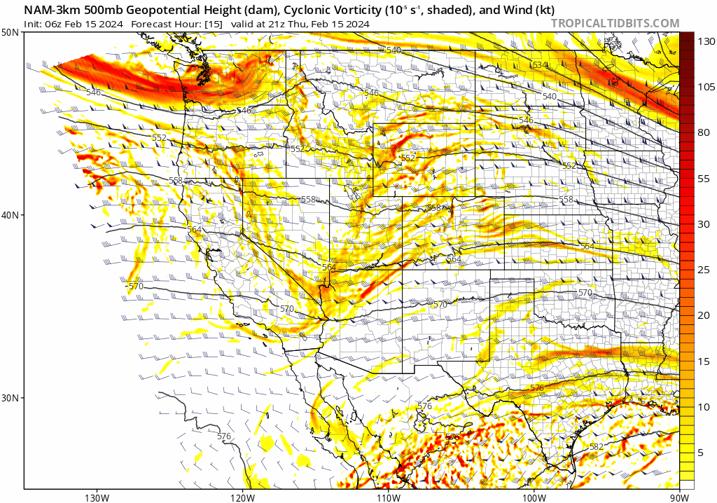
The main development in the forecast we’ve seen throughout the week is for a more substantial mid-level disturbance to drop through Friday night into early Saturday — lagging about 24 hours behind the preliminary surface cold front. This feature can be seen in the 500mb vorticity animation below — it arrives to Colorado by way of Montana and Wyoming.
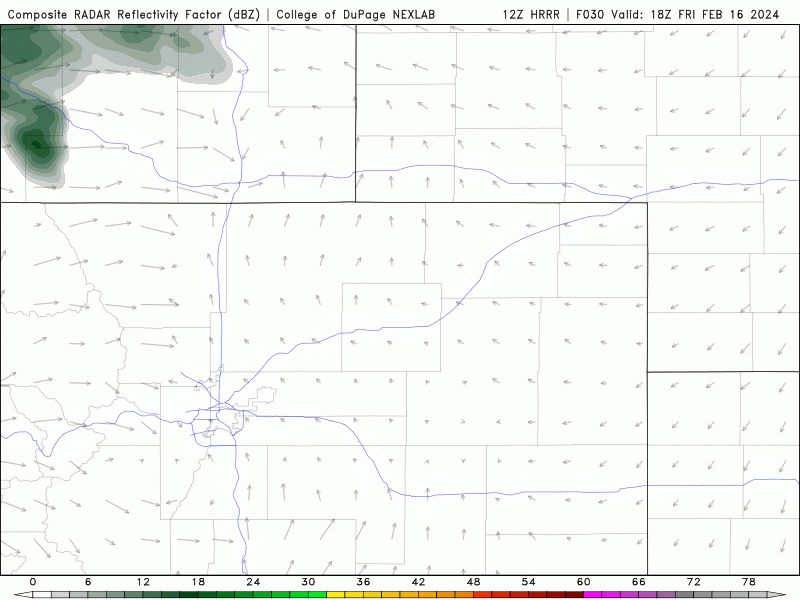
An associated secondary cold front will move through Friday evening producing weak mid-level frontogenesis, cooling aloft, a better surge of northeasterly upslope, and decent large-scale lift. All of these factors will come together to generate a round of light to moderate snowfall for our entire area Friday afternoon into late Friday night. The HRRR model-simulated radar forecast below shows how these bands of snow may develop on Friday, commencing during the late afternoon and continuing into the wee morning hours of Saturday.
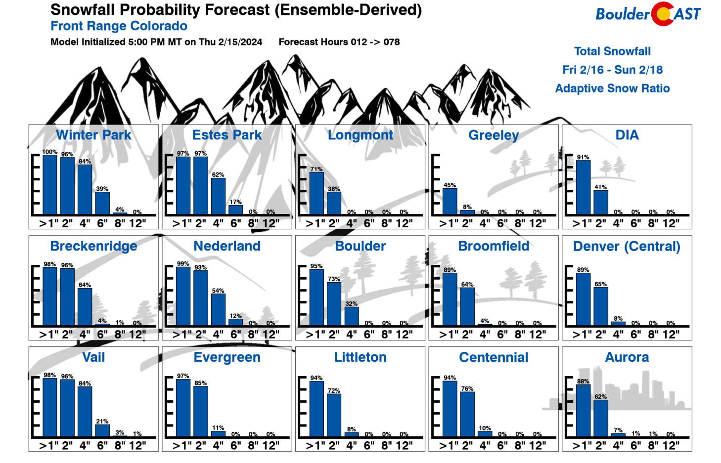
This system will be colder than the last two storms we’ve seen — coincidentally both of those likewise led to snowy Saturday mornings — so snowfall is expected to be fluffier and stick better this time around. The overnight timing will help with that latter aspect, too. Still, this storm isn’t as moisture-rich as the prior two southern-track winter storms we had and the forcings will be quick to pass, only lasting about 8 to 12 hours from the first to the final snowflakes. Thus, snowfall accumulations will be somewhat but widespread across the Metro area. Our snowfall forecast map for this late-week event is shown below. Generally we’re looking at a broad brush of 1-4″ for most of the Metro area. However, locations in and near the Foothills, including Boulder, could see slightly higher totals of 3-8″.
Despite the lighter snowfall totals, temperatures will be falling into the 20s or even the teens overnight Friday night which will support snow-covered roadways across the entire Denver Metro area and the Foothills. Expect slick travel conditions to develop late Friday evening into early Saturday.

Finally, we wanted to comment on the uncertainty with this snow event, or lack thereof actually. The prior two weekend storms were plagued by very challenging forecast components:
- Two weekends ago (Feb 2-3): A moisture-infused, daytime storm where temperatures were warm made for a very tricky snow forecast as rain changed to snow and heavy snowfall rates led to just enough cooling for deep, slushy accumulations. If you recall, this was Boulder’s all-time wettest February storm!
- Last weekend (Feb 9-11): A somewhat easier forecast with temperatures plenty cold for snow, but fine-scale convective snow bands made for a tricky forecast too. We knew some areas would see booming snow totals, it just wasn’t clear where that would be leading up to the event. Those in Greeley can attest to those bands hitting hard — they saw a foot of snow!
Fortunately, this incoming snow event is much less complicated and models are all on-board for a quick shot of widespread light to moderate snow. There’s excellent model agreement on timing, temperatures and amounts. Thus, we’re not expecting any real surprises this time around. Our latest Snowfall Probability Charts below show the range of potential snowfall totals, all generally on the light side. Most of the Front Range has excellent chances for 2″+ of snow, with Boulder having some of the best odds of more than 4″.
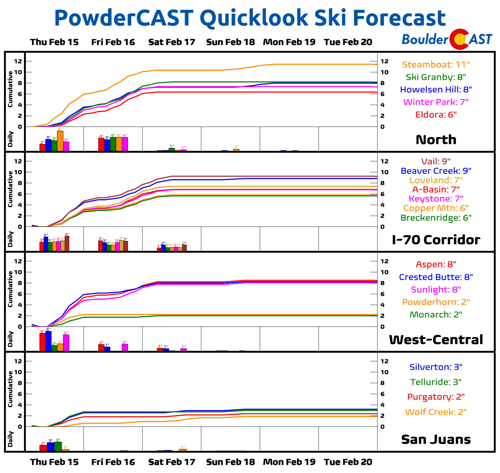
The Mountains will see two waves of snow in the coming days — the first is Thursday into Thursday evening. After a slight lull in the action, snow will increase again Friday morning into Friday night. Snowfall totals in the High Country peaks will range from 4-10″ north of Interstate 70, with 2-6″ south of there. Steamboat is once again favored to see the most snow from this predominantly northwest flow pattern in place — around a foot of snow is hitting there.
Beyond the snow, our weather will turn quiet heading through the weekend into early next week with temperatures moderating back above normal by Monday.
Be sure to follow us on Twitter, Facebook, and Threads for additional updates on this minor winter storm as it approaches and unfolds. We’ll also have a final storm discussion posted Friday morning on BoulderCAST Premium. Enjoy the snow!
Get BoulderCAST updates delivered to your inbox:
Go Premium, get all the perks.
Daily Forecast Updates
Get our daily forecast discussion every morning delivered to your inbox.
All Our Model Data
Access to all our Colorado-centric high-resolution weather model graphics. Seriously — every one!
Ski & Hiking Forecasts
6-day forecasts for all the Colorado ski resorts, plus more than 120 hiking trails, including every 14er.
Smoke Forecasts
Wildfire smoke concentration predictions up to 72 hours into the future.
Exclusive Content
Weekend outlooks every Thursday, bonus storm updates, historical data and much more!
No Advertisements
Enjoy ad-free viewing on the entire site.
Enjoy our content? Help us out and give it a share:


You must be logged in to post a comment.