We take a look at regional snow totals from the past few days as the dry pattern finally came to an end for Front Range Colorado.
I
t had been more-or-less dry across the Denver Metro area since a snowstorm all the way back on November 24th before Thanksgiving. More than half of this dry time was related to a blocking pattern that persisted across the western United States much of early December.
Today will be our 6th consecutive day with sunny skies. This tranquil stretch is the result of a stagnant atmospheric pattern known as a rex block which developed late last week over the western US. Highs Tue & Wed will soar into the 60's in Denver#COwx #RexBlock pic.twitter.com/aBey25z655
— BoulderCAST Weather (@BoulderCAST) December 8, 2020
With things finally turning more active in the Rockies, the pattern was primed to change. Two approaching storm systems, while weak, together were showing the potential to produce decent snowfall for us (by La Niña standards at least). In our winter weather forecast update on Wednesday, we predicted the following preliminary snowfall amounts for the two systems.
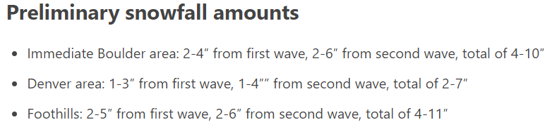
As you can see, we expected the second wave of snow Saturday evening to be slightly stronger than the first wave which occurred Thursday night and Friday. We weren’t even that bullish with our expectation for up to 10″ in Boulder. This was below some of the model guidance at the time.
In any case, the first storm came and went with totals landing on the low-end of expectations just about everywhere. Boulder reported 2.7″ and Denver reported 1.2″. We talked a bit about this storm’s outcome in a follow-up post, but basically we believed poor model forecasts for moisture availability were the root cause of the low-end totals. While it snowed for quite a long time in Boulder (upwards of 18 hours), snowfall rates bordered on pathetic the entire time.
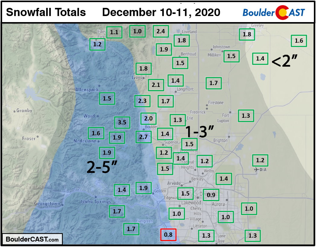
Shown above is our snowfall forecast map issued Thursday morning with actual storm totals overlaid in boxes. Green boxes indicate that our forecast verified to within one inch of the observed snowfall. Red did not.
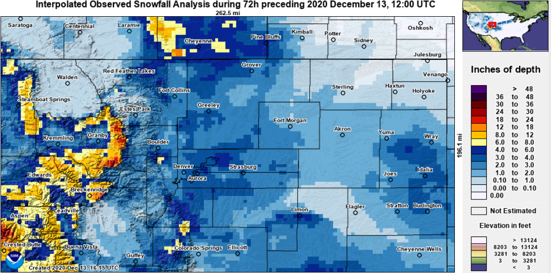
The second round on paper should have produced more snow than the first as the system was stronger and colder. This was true in some locations, but not the case in others, as you can see below.
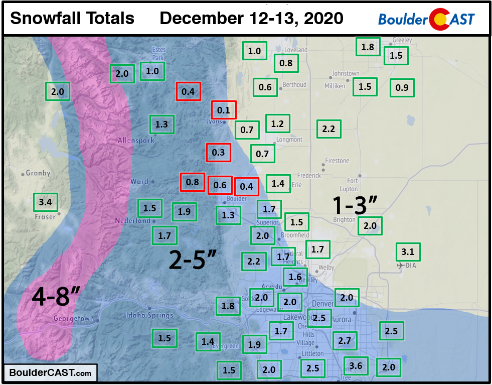
Shown above is our snowfall forecast map issued Saturday morning with actual storm totals overlaid in boxes. Green boxes indicate that our forecast verified to within one inch of the observed snowfall. Red did not.
The Boulder area was skunked the hardest from this second storm, receiving around 1″ of snow (1.3″ officially). Right as things started to come together Saturday evening, we knew there was a problem unfolding. Localized terrain effects were causing the low-level easterly winds to swirl and effectively turn westerly in the Boulder area (a Denver cyclone!). Instead of favorable upslope to enhance snowfall in Boulder, unfavorable downslope was having an opposite effect. This downsloping was observed from Boulder northward through Lyons and Loveland to Fort Collins, which all received very little snow from storm number two.
It is downsloping hard northwest of Denver right now. Based on radar it is probably going to significantly impact snow totals in the Boulder area pic.twitter.com/SrHxzhPAr3
— BoulderCAST Weather (@BoulderCAST) December 13, 2020
When it was all said and done, the entire Metro area ended up with 3-day snow totals of 2 to 4″, a far cry from what could have transpired with this pattern. Still though, it was not far off from our preliminary expectations from the middle of last week.
Here are some of the 3-day totals with Denver International Airport shockingly leading the pack:
- Denver (DIA): 4.3″ (1.2 + 3.1)
- Boulder (official): 4.0″ (2.7 + 1.3)
- Littleton: 3.8″ (1.3 + 2.5)
- Aurora: 3.7″ (1.0 + 2.7)
- Arvada: 3.5″ (1.5 + 2.0)
- Denver (downtown): 3.4″ (0.9 + 2.5)
- Greeley: 3.3 (1.8 + 1.5)
- Louisville: 3.2″ (1.2 + 2.0)
- Nederland: 3.1″ (1.5 + 1.6)
- Evergreen: 3.1 (1.7 + 1.4)
- Lakewood: 2.7″ (1.0 + 1.7)
- Erie: 2.7″ (1.3 + 1.4)
- Loveland: 2.6 (1.8 + 0.6)
- Longmont: 2.4″ (1.7 + 0.7)
- Lyons: 1.9″ (1.8 + 0.1)
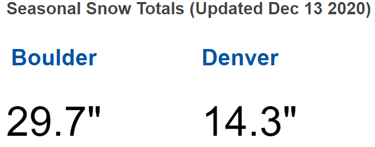
Seasonal totals for Boulder and Denver are shown below. Boulder is running slightly above normal so far, while Denver is slightly below normal.
Visit our 2020-2021 Winter Snow Summary
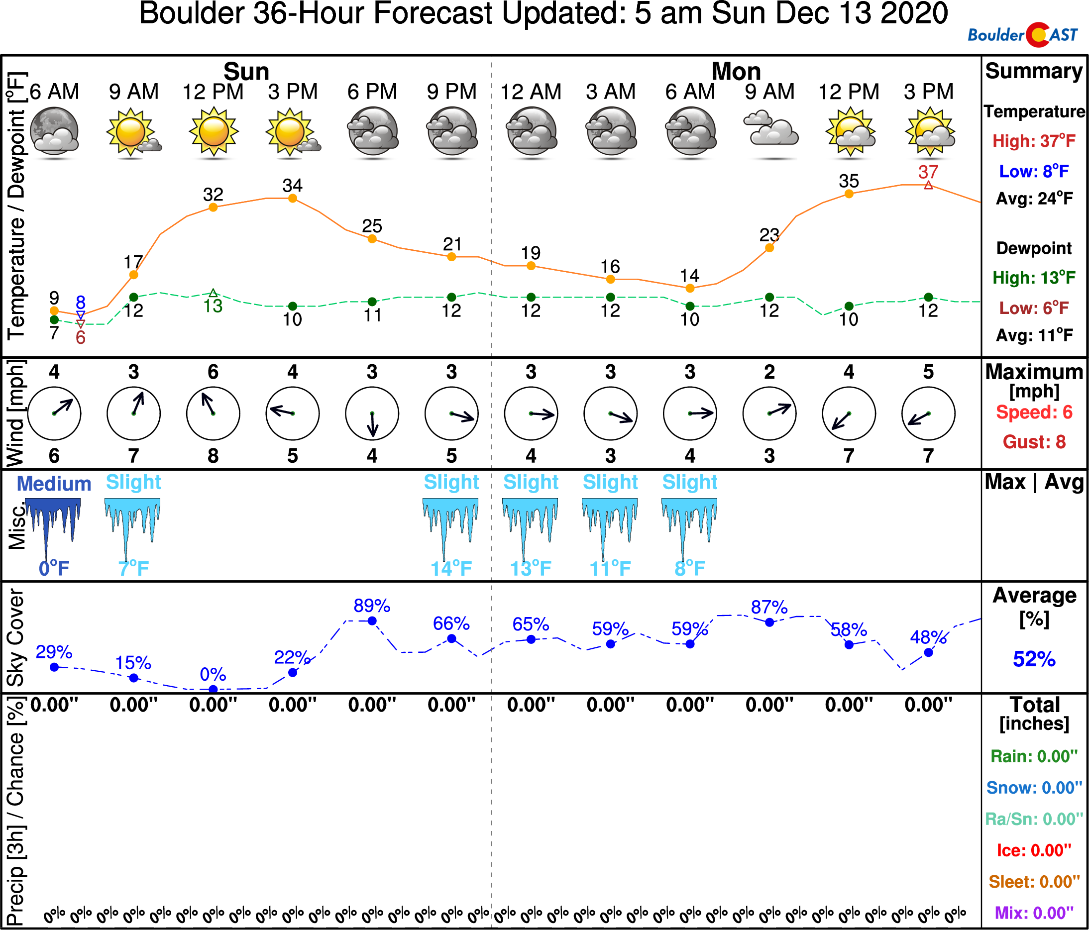
The pattern is set to remain relatively active for the week ahead in the western United States, but nothing piques our interest yet for major weather events in the Metro area. We’ll see another round of very light snow Monday night. As it stands now, little to no accumulation is expected with this system. We’ll surely have more to add on this tomorrow in our usual weekly weather outlook. Enjoy the rest of your “Sun”-day!
Help support our team of Front Range weather bloggers by joining BoulderCASTPremium. We talk Boulder and Denver weather every single day. Sign up now to get access to our daily forecast discussions each morning, complete six-day skiing and hiking forecasts powered by machine learning, first-class access to all our Colorado-centric high-resolution weather graphics, bonus storm updates and much more! Or not, we just appreciate your readership!

.
Spread the word, share this BoulderCAST post:
.


You must be logged in to post a comment.