Change is on the horizon for the Boulder and Denver area. Today will be the last warm day before a cold front arrives early Thursday morning followed by two (yes two!) light snow events taking us right into the weekend. Let’s have a look at the timeline and preliminary snowfall amounts as winter weather returns to the Front Range.
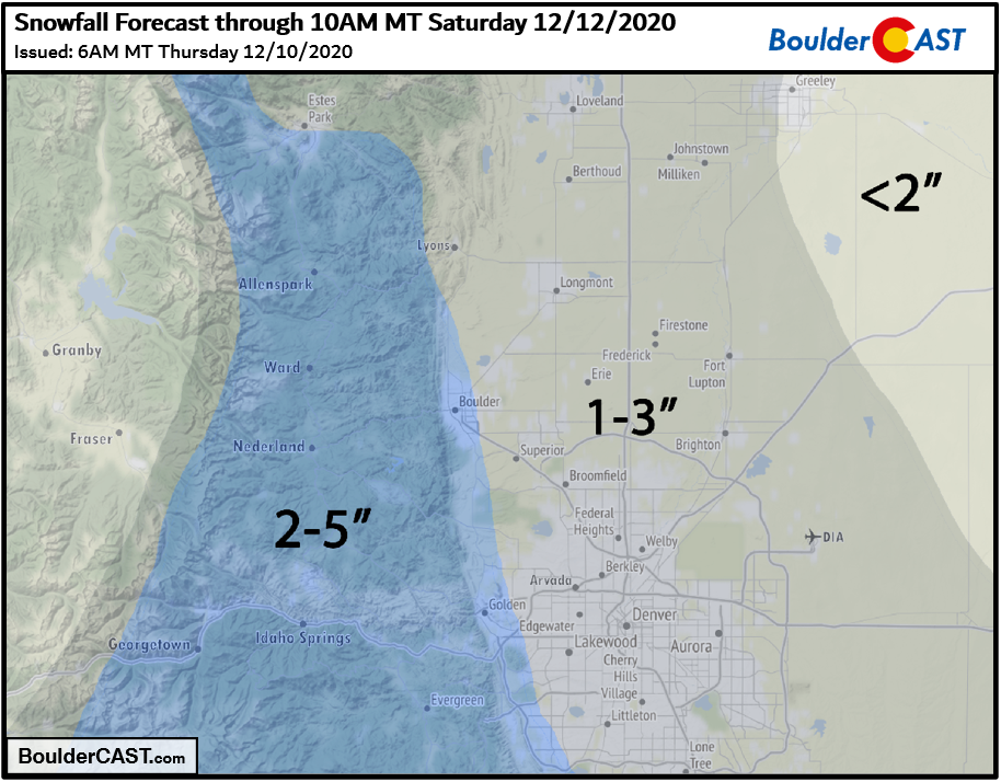
UPDATED 6:00AM Thursday: Added our snowfall forecast map for the first wave of snow falling Thursday night through Friday night.
At a Glance:
- The 60’s of Wednesday will be replaced by much colder weather in the days ahead
- Two separate snow events will impact Front Range Colorado Thursday afternoon into Sunday morning
- The second storm is somewhat uncertain with the potential to produce more substantial snow totals (or at least bursts of heavier snowfall)
- Near or below freezing temperatures expected Friday and Saturday
- The potential exists for 4-10″ snow totals around Boulder, 2-6″ in Denver
Help support our team of Front Range weather bloggers by joining BoulderCAST Premium. We talk Boulder and Denver weather every single day. Sign up now to get access to our daily forecast discussions each morning, complete six-day skiing and hiking forecasts powered by machine learning, first-class access to all our Colorado-centric high-resolution weather graphics, bonus storm updates and much more! Or not, we just appreciate your readership!

Three systems to watch
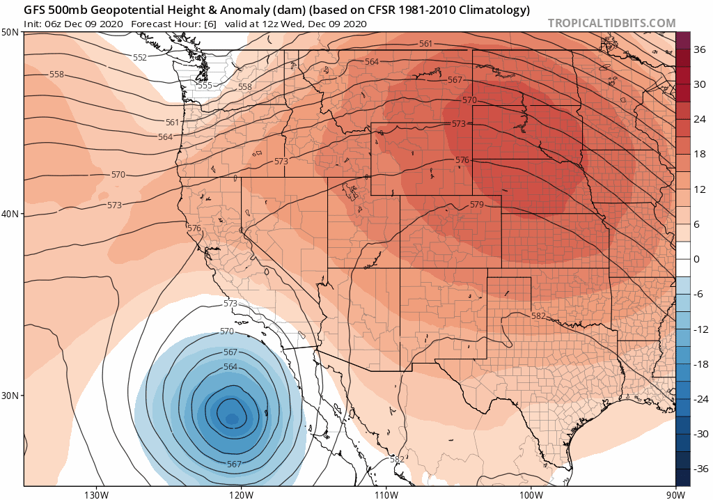
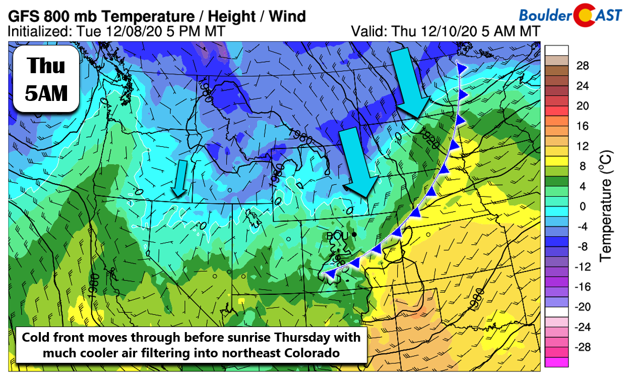
Several storm systems will pummel Colorado in the coming days, with the first arriving late in the day Thursday compliments of a southern-track low moving up from the Desert Southwest. The energy from this southern low will largely bypass our area to the south. At the same time, a weaker open wave will push into the area from the northwest helping to bring a cold front through the Denver Metro area well before sunrise Thursday. The merger of the weakening two storms across Colorado can be seen in the GFS forecast 500mb height anomaly animation below. Also of note is a third, colder system which looks to arrive Saturday and Saturday night bringing another chance of snow to the area. We’ll talk about both snowfall events in this forecast update.
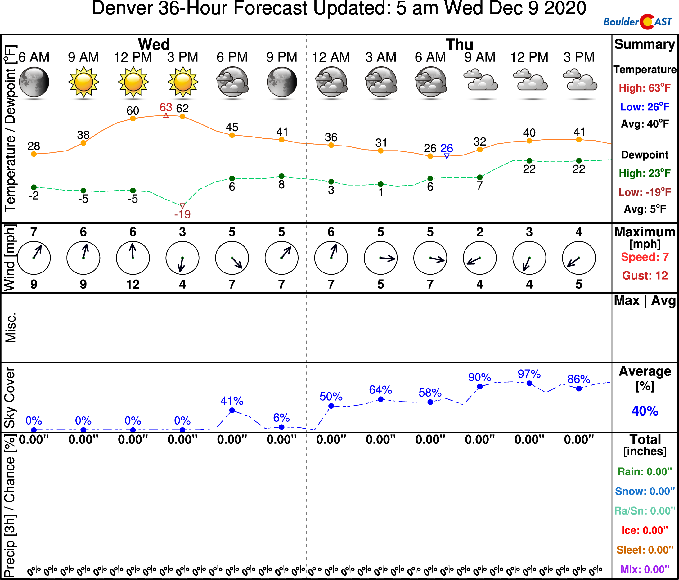
Resulting from the merger of the first two systems, shallow upslope and weak large-scale lift will consume much of northeast Colorado late Thursday into Friday. Initially the lower atmosphere will be very dry, so most of the day Thursday will simply be cloudy and cold following the cold front. Highs will be around 40 degrees, a substantial drop from where we will be on Wednesday in the 60’s.
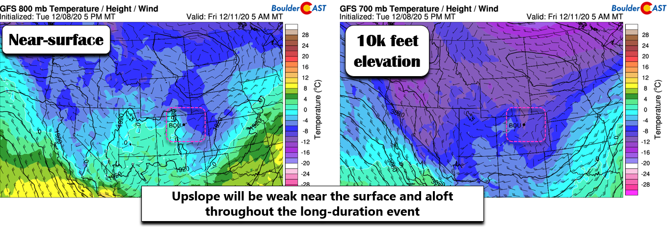
By Thursday evening and night, we should start to see widespread light snowfall develop across the Metro area with saturation in the lower atmosphere occuring. Upslope and lift will be weak so snowfall rates should remain fairly light albeit consistent Thursday night and through the day Friday. Shown below are temperature and wind forecasts from the GFS at the surface (left) and 10,000 feet elevation (right) for early Friday morning. Notice how weak the winds speeds are, despite the favorable easterly wind directions.
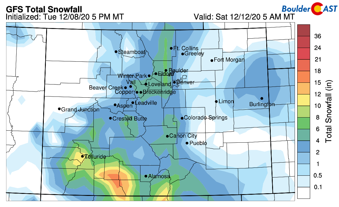
This type of setup tends to favor the far western Metro area and the lower Foothills for the most snowfall with upslope a weak but key component. Even still, we’re only looking at a few inches of snowfall, at least from the first wave of activity Thursday night into Friday night. Shown below is the latest GFS snowfall forecast through Saturday morning. This is about on par with other models at this time: 1-3″ in Denver, 2-4″ in Boulder and the Foothills.
The most challenging aspect of the upcoming forecast will be determining what happens with the secondary, much colder storm system targeting Colorado Saturday into early Sunday. Substantial model differences remain with a low pressure set to drop out of western Canada and into Colorado on Saturday. Below shows a 500mb forecast snapshot from the GFS model (left) and European model (right) for 5PM Saturday. Not only does the Euro model show the system arriving earlier, it comes in stronger and more closed-off with a fairly good track supportive for snow in the Front Range. The GFS brings the entire storm system into our area slower and weaker.
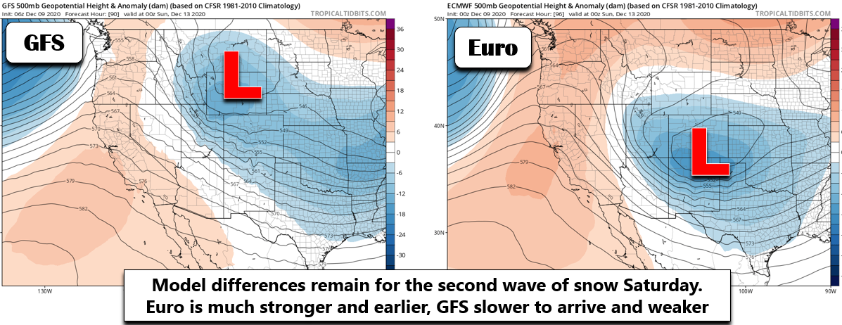
These model differences may not seem that like much at first glance, but there will certainly play into what transpires on Saturday. With the European solution, we may not see much of a break between the first wave of snow and the second with snow falling much of the day Saturday, whereas the GFS is predicting a roughly 18-hour break in the action before things pick back up again Saturday evening. We’ll need to watch this secondary system in the coming days as we believe it has the potential to produce even more snow than the first one.
Timeline
- Wave #1 of Snow: Light snow will begin to develop Thursday afternoon in the higher terrain and spread across the Plains Thursday evening and night. This period of upslope snow will favor the lower Foothills and immediately adjacent areas like Boulder and Golden. Snowfall rates will be generally light (less than 1/2″ per hour) but the event will be long-winded, lasting all the way into Friday night. Our confidence in this wave of snow is somewhat high.
- Wave #2 of Snow: Depending on which model solution ultimately verifies, this secondary period of snow could begin Saturday morning OR Saturday evening. More energy and upslope will exist with this wave, so snowfall rates will be more intense and spread further from the base of the Foothills. It will also be a colder storm with higher snow ratios. This wave appears to be the more fruitful of the two, but it is more uncertain for sure. Expect either a day of continued snow through the day Saturday, or a break in the action with snow resurging Saturday evening. Regardless of which outcome occurs, snow should wrap-up by early Sunday.
Preliminary snowfall amounts
- Immediate Boulder area: 2-4″ from first wave, 2-6″ from second wave, total of 4-10″
- Denver area: 1-3″ from first wave, 1-4″” from second wave, total of 2-7″
- Foothills: 2-5″ from first wave, 2-6″ from second wave, total of 4-11″
Our snowfall forecast map for ONLY the first wave of snow is shown below. This covers snow falling Thursday night through Friday night. Saturday’s snow is NOT included in this forecast map.
Final comments
The long duration of mostly light snow with the two snow events will lead to largely manageable travel impacts though expect some slick spots especially during the overnight periods. While confidence for the first snowfall event is fairly high, we do remain cautious of the second storm which has the look in at least some model solutions of a potentially more impactful, closed-low storm. Nothing is fully set in stone yet though as all three of the low pressure systems involved have not moved over land yet from the Pacific Ocean as of Wednesday morning.
The return of winter weather will be abrupt considering the lengthy period of warm/sunshine we’ve had the last seven days. However, the cold weather knocking on the door certainly is more appropriate for mid-December….
Today will be our 6th consecutive day with sunny skies. This tranquil stretch is the result of a stagnant atmospheric pattern known as a rex block which developed late last week over the western US. Highs Tue & Wed will soar into the 60's in Denver#COwx #RexBlock pic.twitter.com/aBey25z655
— BoulderCAST Weather (@BoulderCAST) December 8, 2020
We’ll continue to monitor the evolving forecast closely and issue our official snowfall forecast map sometime on Thursday, so do stay tuned!
Get BoulderCAST weather updates delivered to your inbox!
We respect your privacy. You can unsubscribe at any time.
Help support our team of Front Range weather bloggers by joining BoulderCASTPremium. We talk Boulder and Denver weather every single day. Sign up now to get access to our daily forecast discussions each morning, complete six-day skiing and hiking forecasts powered by machine learning, first-class access to all our Colorado-centric high-resolution weather graphics, bonus storm updates and much more! Or not, we just appreciate your readership!
.
Spread the word, share this BoulderCAST post:
.


You must be logged in to post a comment.