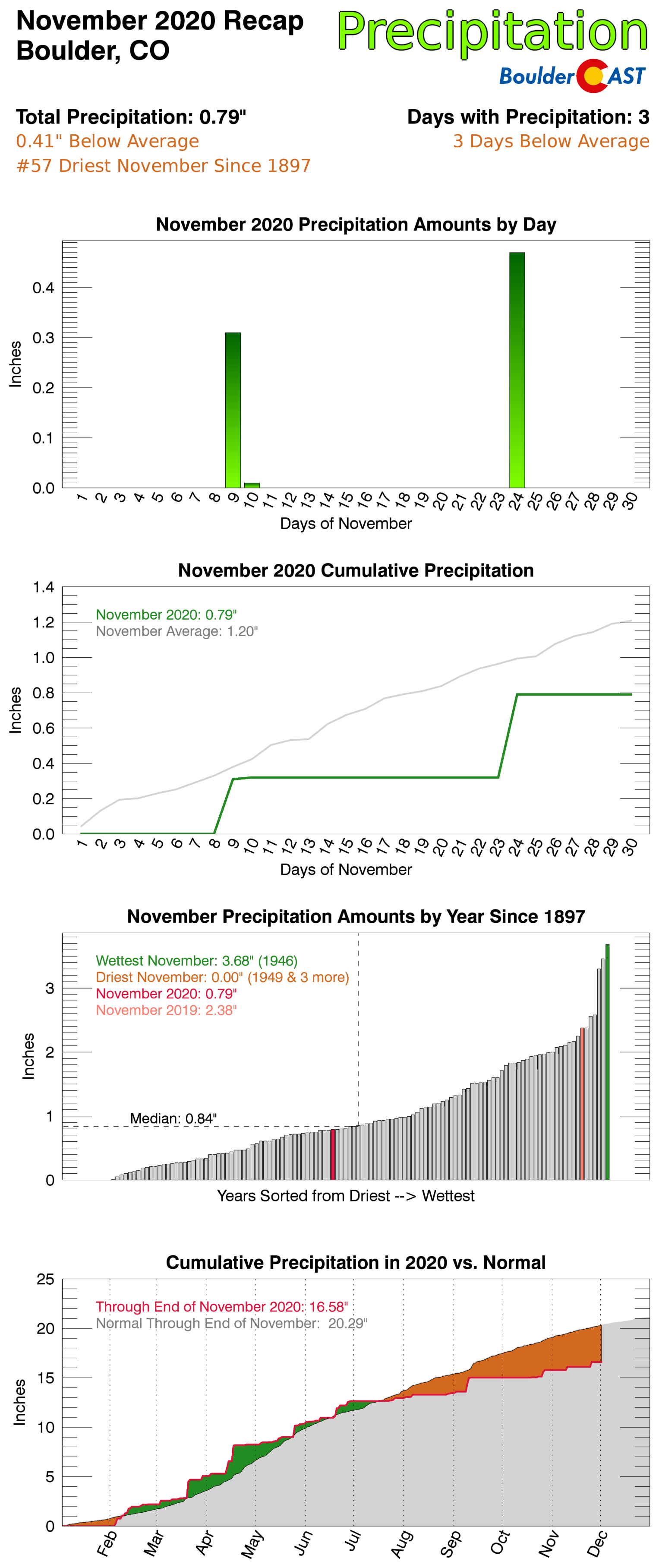
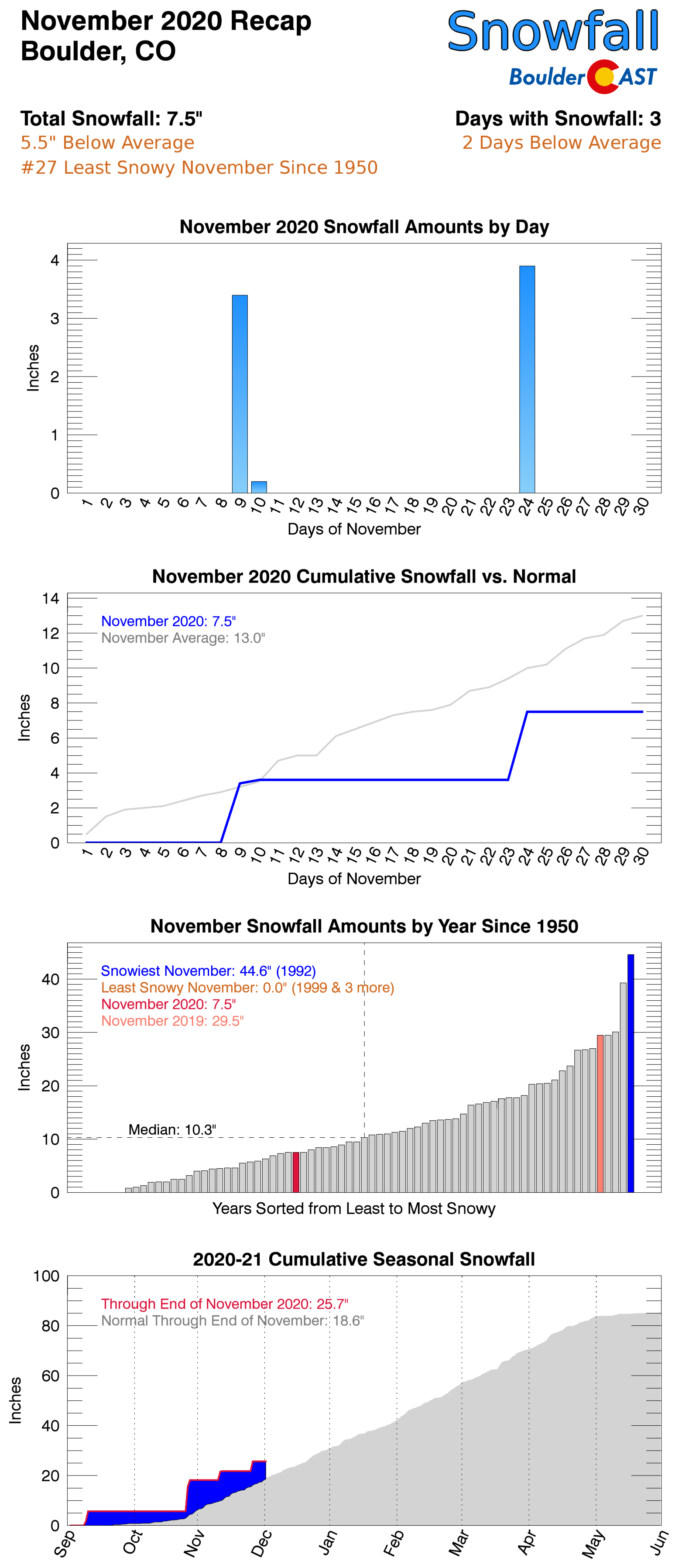
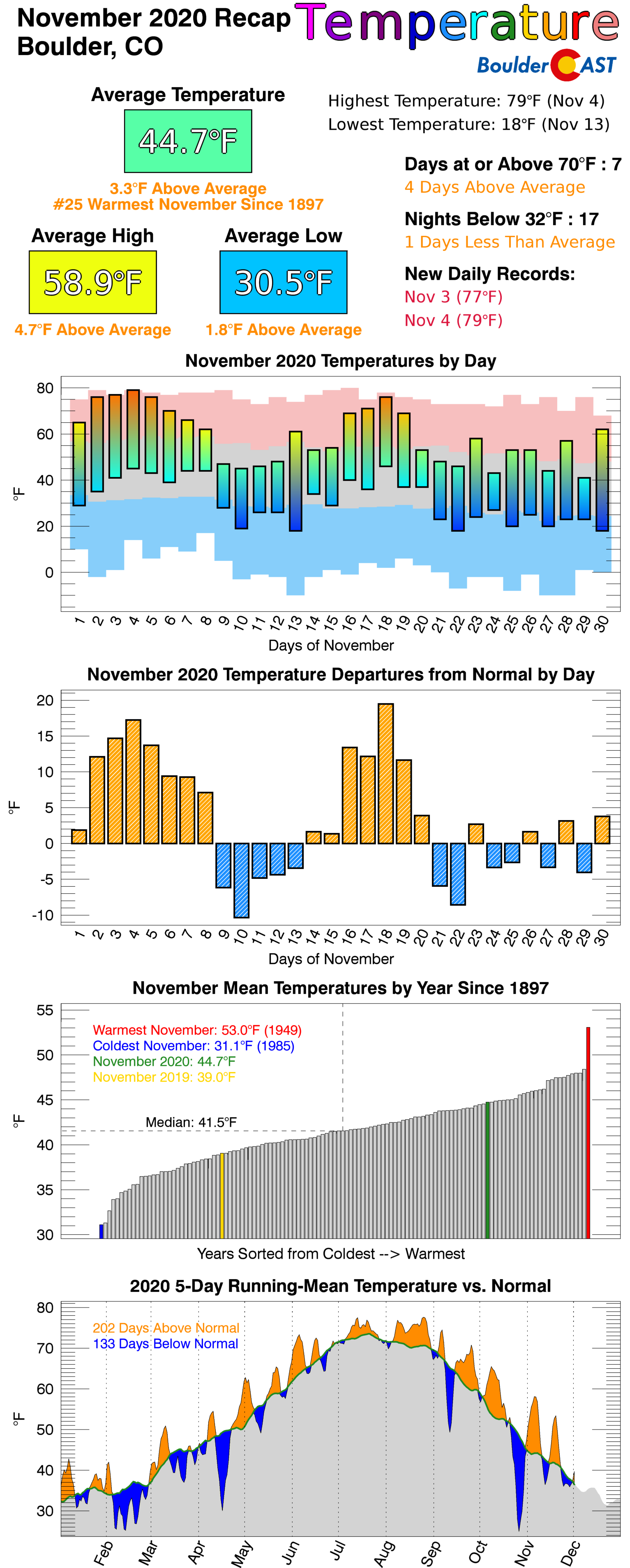
November 2020 ended up quite a bit different than November 2019 which was one of the coldest for our area. The month began with a record warm stretch but eventually had a few snow events. Overall, though, it was a very warm and fairly dry month which is just what we predicted. Here’s a quick and colorful rundown of our weather during November and how it relates to climatology.
Help support our team of Front Range weather bloggers by joining BoulderCAST Premium. We talk Boulder and Denver weather every single day. Sign up now to get access to our daily forecast discussions each morning, complete six-day skiing and hiking forecasts powered by machine learning, first-class access to all our Colorado-centric high-resolution weather graphics, bonus storm updates and much more! Or not, we just appreciate your readership!

Top Weather Highlights of November 2020:
RECORD WARM STRETCH: The month of November began with a stretch of 70-degree days for the area. Boulder tied record highs on November 3rd and 4th, and came up just two degrees short on the 5th. The 79°F reached on the 4th was the second warmest November temperature ever in Boulder.
Closing in on record heat for the third consecutive day. Not a cloud in the sky and very warm temperatures already as of 1:00PM. It will be close. Existing records to beat: 78° in Boulder, 77°F in Denver #COWX #RecordHeat #Boulderwx # pic.twitter.com/L3i3UESEIz
— BoulderCAST Weather (@BoulderCAST) November 5, 2020
LIGHT SNOW HITS PARTS OF METRO: One of two snow events in the Metro was forced by upslope on November 9th and 10th. 1-3″ of snow fell cross the western Metro area with 3-6″ in the Foothills.
Here are the snowfall totals from Monday ❄️
Boulder 3.4", Denver (DIA) only a trace #COwx #SnowWe had nearly a perfect forecast. Thanks for ruining it, @TownofEstesPark …
Check out our summary page for snowfall events so far in the 2020-2021 season: https://t.co/PtfoYuE7E8 pic.twitter.com/zX5K4PPCTD
— BoulderCAST Weather (@BoulderCAST) November 10, 2020
GREEK LETTERS HIT NICARAGUA? November is normally at the tail-end of Atlantic Hurricane season. However, 2020 has been far from normal in the Atlantic. Two major hurricanes made landfall within 15 miles of one another in the small Central American country of Nicaragua this month….less than 2 weeks apart. Category 4 Eta and then Category 5 Iota, both caused catastrophic damage, flooding, and landslides in the area. By the end of November, 2020 had eclipsed many of the records for Atlantic Basin tropical cyclones.
Let's not forget what happened with the hurricanes in November.#Eta became the strongest Atlantic #hurricane on record to make landfall in Nicaragua in November (Cat. 4, 140 mph winds). #Iota then reached cat 5 only 2 weeks later and slammed the same communities (as cat 4). pic.twitter.com/Ii26p8Kwzp
— Scott Duncan (@ScottDuncanWX) December 1, 2020
A SECOND SMALL SNOW EVENT: Model challenges with an incoming storm system led to some poor forecasts for a snow event which produced a swath of widespread heavy snowfall in the Metro area around sunrise on November 26th. Our team saw this snow coming to some degree, so our forecast didn’t turn out too bad. However, some areas of northwest Denver received up to 8 or even 10″ of snow when they may have been expecting a measly inch!
Snow for everyone this morning…and heavy snow at that!
More regional webcams: https://t.co/L0VLejKuY3#COWX #Snow pic.twitter.com/6RqAvza0pG
— BoulderCAST Weather (@BoulderCAST) November 24, 2020
Here are the snowfall storm totals from Tuesday overlayed on our forecast map. This quick hitting snowstorm was an overproducer in some areas. Officially 3.9" in Boulder, 5.0" in Denver #COwx #Snow
Check out all the storms from the season so far here: https://t.co/PtfoYuVJ2I pic.twitter.com/SexelkZzL9
— BoulderCAST Weather (@BoulderCAST) November 26, 2020
November 2020 Recap Graphics:
.
Spread the word, share Colorado’s crazy weather:
We discuss Boulder and Denver weather every single day on BoulderCAST Premium. Sign up today to get access to our daily forecast discussions every morning, complete six-day skiing and hiking forecasts powered by machine learning, access to all our Front Range specific weather models, additional storm updates and much more!


You must be logged in to post a comment.