After our second snowy weekend in a row, things will stay quiet across the Front Range for much of the upcoming week with seasonal temperatures and lots of sunshine. However, that will change late-week as a quick-hitting Arctic cold front will surge south across the area. This front will likely be accompanied by at least a little bit of wintry precipitation, but the cold won’t stick around long at all. We also look ahead to several more devastating atmospheric river events set to slam California — their remnant moisture will likely spread into our Mountains to further bolster statewide snowpack. Read on for all the details.
This week’s highlights include:
- Seasonal Sunshine and Melting Snow: Expect mostly sunny and quiet weather for the first half of the week, with temperatures around 50 degrees each day through Thursday.
- Arctic Front and Light Snow Late-Week: A cold front will arrive late Thursday or early Friday, bringing gusty winds, colder temperatures, and a chance of light snow or freezing drizzle. Accumulations are expected to be minor, with less than 1 inch for most areas.
- Improving Conditions for the Weekend: The Arctic airmass looks to clear out quickly, with highs returning to the 40s on Saturday and 50s on Sunday.
- Mountain Snowpack Update: Mountain snowpack has surged statewide back to approximately normal in every single river basin. This week will generate only minor snow in the High Country, but the weekend into next week will turn active again with moisture spreading in from several devastating atmospheric river events in California.

DISCLAIMER: This weekly outlook forecast is created Monday morning and covers the entire upcoming week. Accuracy will decrease as the week progresses as this post is NOT updated. To receive daily updated forecasts from our team, among many other perks, subscribe to BoulderCAST Premium.

Go Premium, get all the perks.
Daily Forecast Updates
Get our daily forecast discussion every morning delivered to your inbox.
All Our Model Data
Access to all our Colorado-centric high-resolution weather model graphics. Seriously — every one!
Ski & Hiking Forecasts
6-day forecasts for all the Colorado ski resorts, plus more than 120 hiking trails, including every 14er.
Smoke Forecasts
Wildfire smoke concentration predictions up to 72 hours into the future.
Exclusive Content
Weekend outlooks every Thursday, bonus storm updates, historical data and much more!
No Advertisements
Enjoy ad-free viewing on the entire site.
Sunshine & seasonal temperatures melt the snow!
The southern-track low pressure system, which contributed to the snowfall in the Front Range over the weekend, will continue to sweep across the nation throughout the next couple days.
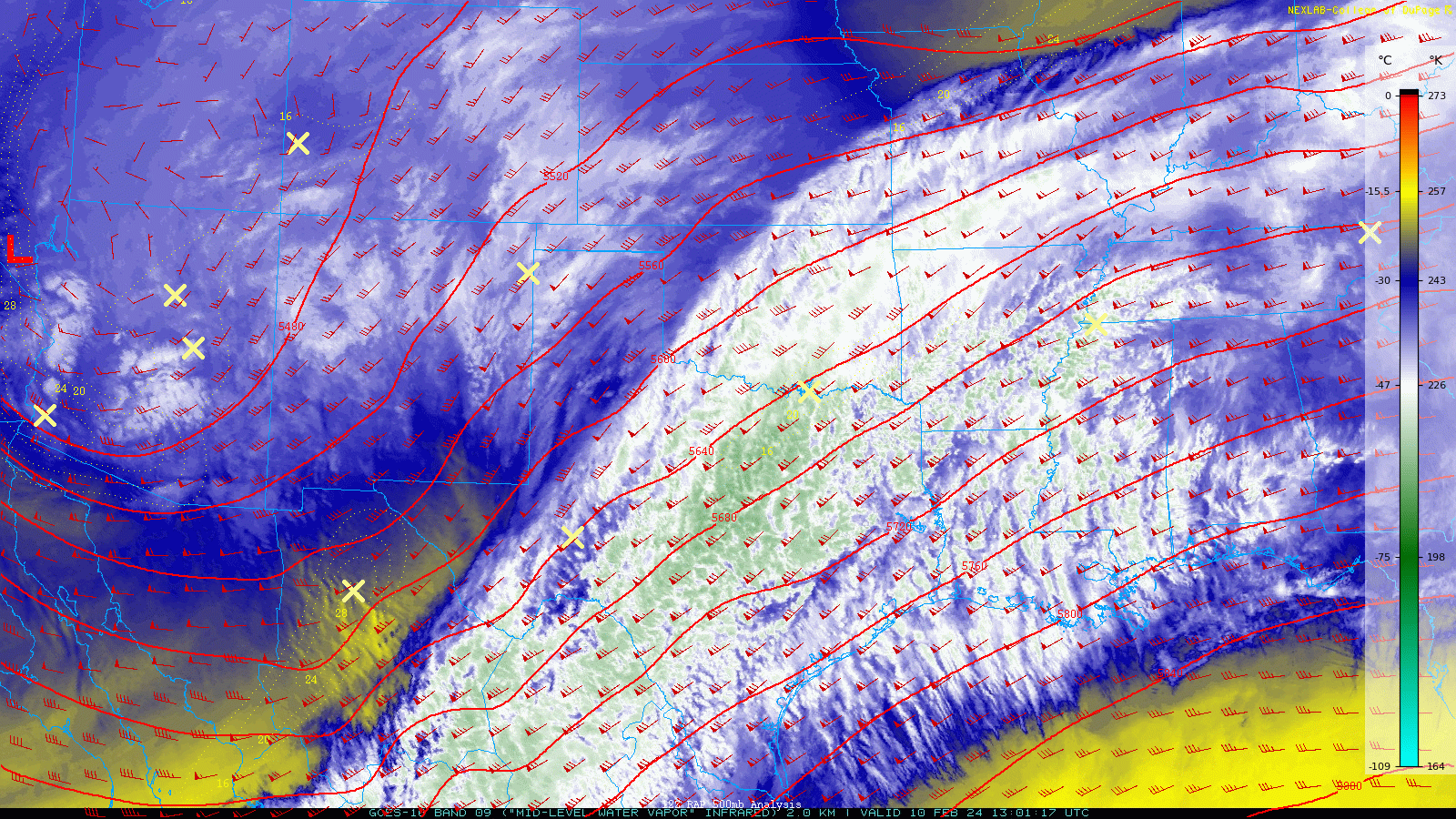
GOES-East water vapor animation from the last few days showing the low passing south of Colorado and now heading east
This storm system will spread heavy rain, snow, and mixed precipitation over portions of the South, Northeast and New England in the process.

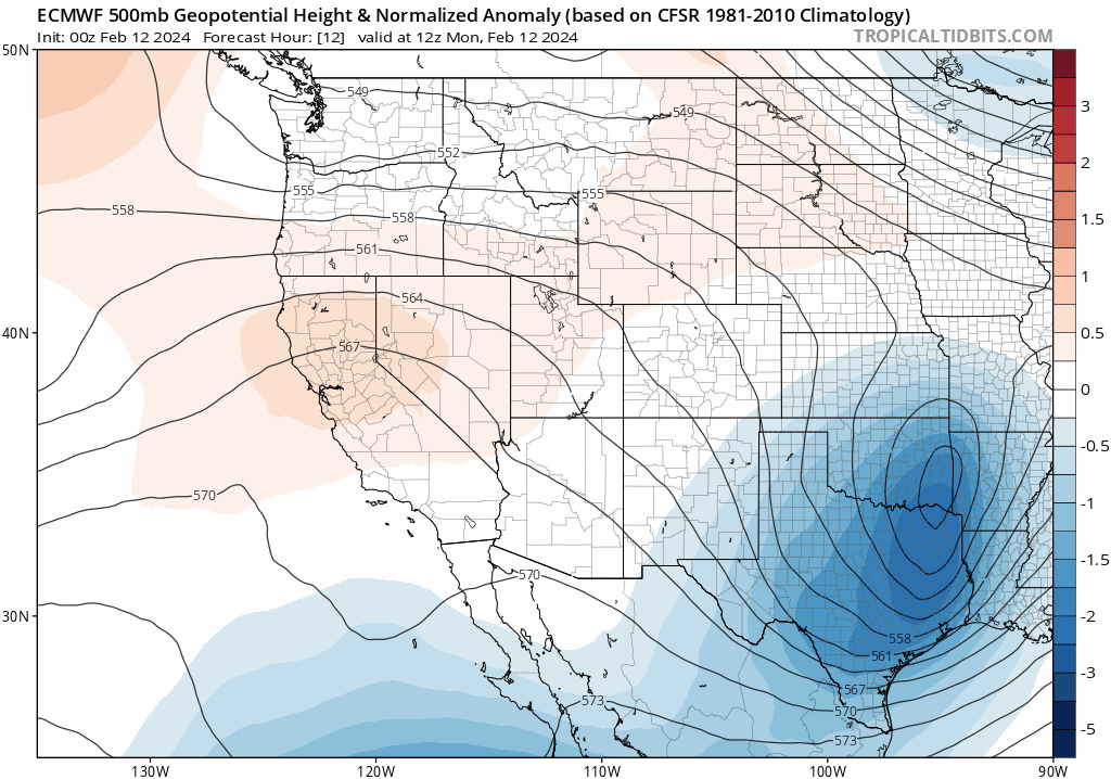
Back across Colorado, however, the next several days will be quiet as relatively dry and calm zonal flow takes over across the West. The ECMWF 500mb height anomaly forecast animation below is rather busy throughout the week, but if you focus solely on Colorado, the overall pattern ahead doesn’t vary much. Our flow aloft will begin northwesterly on Monday, shift to westerly by midweek, before then returning to northwesterly by the weekend. One thing to watch late-week (towards the end of the animation below) is the amplified ridge which develops across the West into western Canada. We’ll talk more about how this feature will impact our weather in a moment.
For now, though, skies will remain mostly sunny with seasonal temperatures heading into midweek. Monday, Tuesday and Wednesday will all see highs around 50 degrees as the weekend snow on the ground continues to melt away. 50 degrees is essentially spot on with our normal temperatures for mid February.

Winter weather returns late in the week
Towards the end of the week, winter weather will return to the Front Range as there is strong model support for an Arctic front to drop southward across the Great Plains, including brushing through eastern Colorado. This surge of Canadian air is getting shunted southward by a strong ridge over Alaska and western Canada helping to displace the cold air.
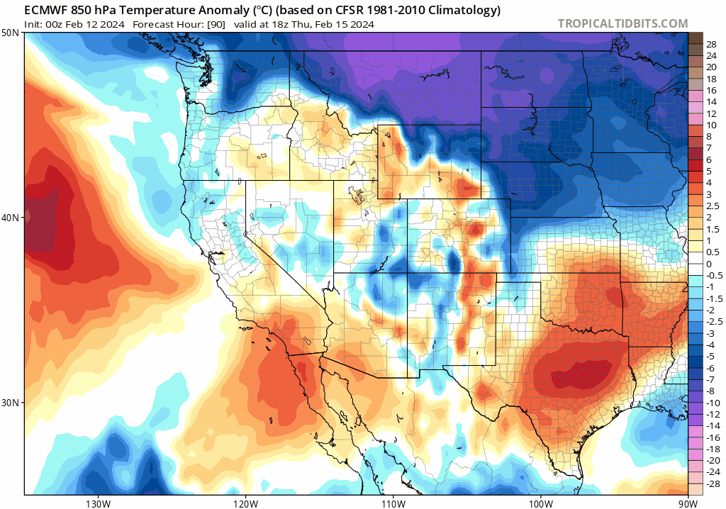
The timing of the front currently varies in guidance from Thursday evening (Euro) to Friday morning (GFS). However, these type of fronts almost always tend to arrive on the early end of predictions this far out. Thus, it is more likely to show up late in the day Thursday for us, per the Euro model. After highs in the low to middle 50s on Thursday, this front will knock about 20 degrees of our temperatures as we fall back towards freezing for Friday with overcast skies and/or low clouds around in the post-frontal airmass.

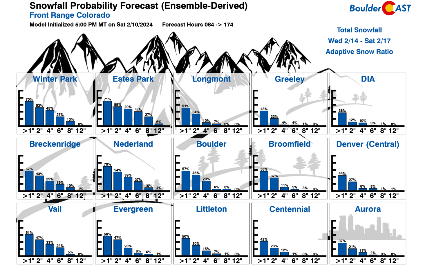
There will probably be some light precipitation accompanying this late-week frontal boundary, both along the front (Thursday afternoon into Thursday night in the form of rain showers changing to snow) and in the post-frontal upslope regime (Thursday night into Friday night in the form of light snow, flurries or freezing drizzle). There’s unsurprisingly still quite a spread in the ensembles regarding the timing AND the amount of late-week precipitation we stand to see. The ensemble median is only around 1″ of snow accumulation in Boulder and Denver.

At this point in time, it is basically a coin flip whether we see more or less than 1″, with the absolute high-end potential of only around 4″. The main take-away for now: don’t get your hopes up too much for snow — this is likely to be only a very minor brush of snow with the colder temperatures being the bigger story for us.
Here’s a look at the extended forecast as we trend from seasonal sunshine towards a return of the cold and snow. Most models have the Arctic airmass clearing out fairly quickly with quiet weather expected for the upcoming weekend and quickly moderating temperatures. Highs will likely return to the 40s on Saturday and then potentially push back into the 50s by Sunday.
There will also be some snow in the Mountains through the week with the meager amount of moisture and subtle shortwaves in the westerly flow at times spawning a few snow showers. Accumulations will be very minor most days (less than 1″), but the late-week system could bring decent accumulations to Colorado’s northern mountains, perhaps 3-8″ for northwest-facing slopes.

The last two weekend winter storms have done wonders for the Mountains (the former, more so than the latter). This is how our statewide snowpack looked about two weeks ago — not terrible but not great:
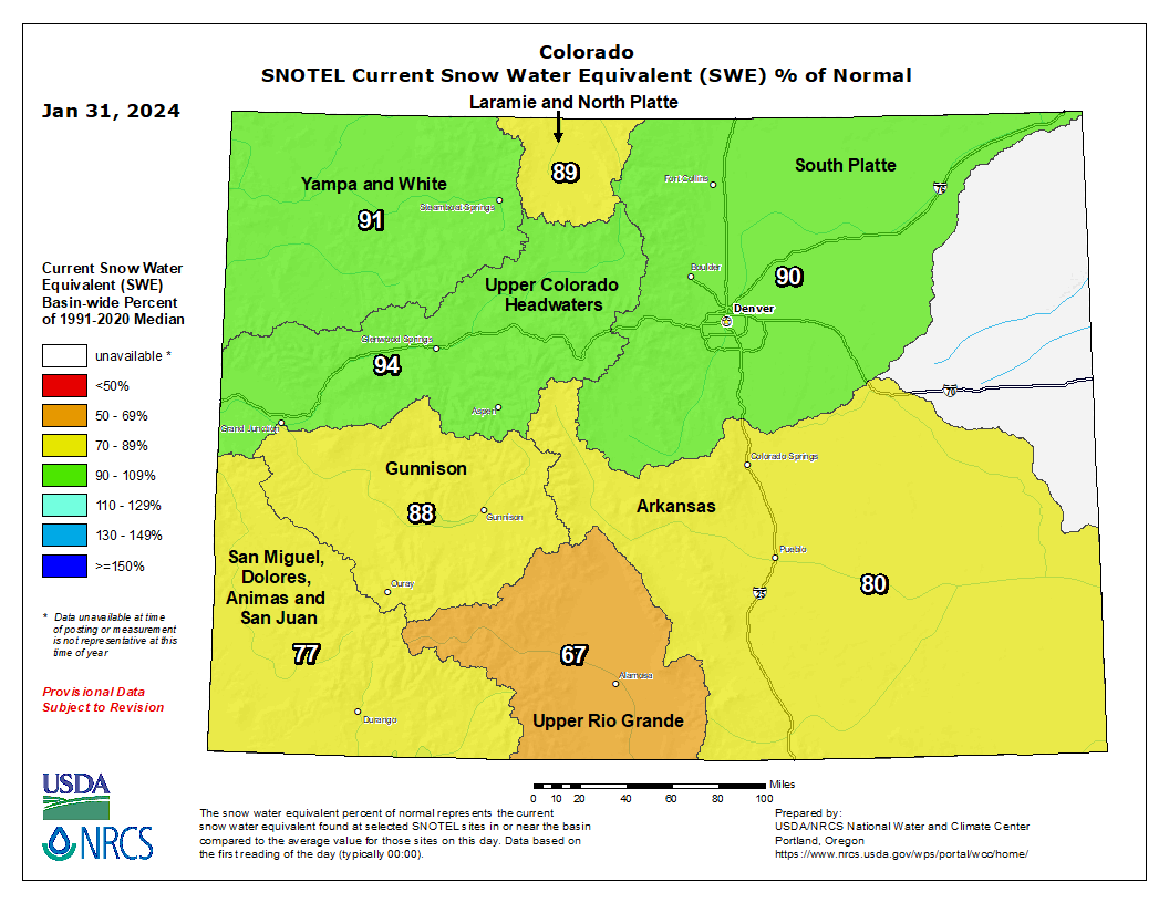
And here we are today — what an improvement!

The onslaught of deadly atmospheric rivers into California is unfortunately expected to ramp up again during the upcoming weekend and into next week, with as many as three subtropically-infused storms poised to slam the Golden State’s coastline — more or less hitting the same areas in succession (expect more flooding and mudslides). Some of this moisture will translate eastward across the Intermountain West, likely bringing decent snow to Colorado’s mountains in the (far) extended as well. Very little, if any, of this moisture is shown to make it over the Continental Divide into the Denver area. Time will tell, though.
That’s a wrap on this week’s outlook — thanks for reading to the end. Our team will continue to monitor the developing Arctic front later in the week, but for now it appears to be just a nuisance of light snow accompanied by one or two chilly days. Have a wonderful week!
Two unlikely friends exploring the fresh snow in #Boulder… #cowx pic.twitter.com/yIciJhZVIE
— BoulderCAST Weather 🏔️❄️ (@BoulderCAST) February 12, 2024
Get BoulderCAST updates delivered to your inbox:
Forecast Specifics:
Monday: A few morning clouds, then mostly sunny. Highs reach the upper 40s on the Plains with middle 30s in the Foothills.
Tuesday: Mostly sunny, dry and quiet. Temperatures top out in the lower 50s on the Plains with upper 30s in the Foothills.
Wednesday: Staying mostly sunny and pleasant. Highs around 50 degrees across the Plains with upper 30s in the Foothills.
Thursday: A mix of clouds and sunshine with an Arctic front likely arriving sometime late in the day or evening. Gusty downslope winds from the west during the day. Rain quickly changing to snow showers may accompany the front.
Friday: Overcast, gloomy and cold with light snow possible during the day, potentially clearing out by the late-day period. Highs much colder only in the lower 30s for the Plains with middle 20s in the Foothills.
Weekend: The Arctic airmass clears out fairly quickly with quiet weather expected for the weekend. Highs will likely return to the 40s on Saturday and potentially into the 50s by Sunday.
DISCLAIMER: This weekly outlook forecast is created Monday morning and covers the entire upcoming week. Accuracy will decrease as the week progresses as this post is NOT updated. To receive daily updated forecasts from our team, among many other perks, subscribe to BoulderCAST Premium.
Go Premium, get all the perks.
Daily Forecast Updates
Get our daily forecast discussion every morning delivered to your inbox.
All Our Model Data
Access to all our Colorado-centric high-resolution weather model graphics. Seriously — every one!
Ski & Hiking Forecasts
6-day forecasts for all the Colorado ski resorts, plus more than 120 hiking trails, including every 14er.
Smoke Forecasts
Wildfire smoke concentration predictions up to 72 hours into the future.
Exclusive Content
Weekend outlooks every Thursday, bonus storm updates, historical data and much more!
No Advertisements
Enjoy ad-free viewing on the entire site.
Enjoy our content? Give it a share!


You must be logged in to post a comment.