Our first snowfall of the season is now behind us, but the bitter cold temperatures that accompanied it are still sticking around. It will take several more days before we have anything resembling normal temperatures across the Front Range. Overall the week ahead will be quiet and mostly sunny with little to be concerned about weather-wise. The upcoming weekend looks rather nice as well. Read on for all the details.
This week’s highlights include:
- Our first snowfall of the season has come and gone with totals ranging from 4 to 12″ alongside sub-freezing temperatures sticking around for something like sixty consecutive hours
- Undoubtedly bland weather will unfold this week across the Front Range as broad ridging moves into the West and the storm track retreats back northward
- No chance for precipitation with temperatures trending upwards each successive day — we start the week in the 30s but end it in the 60s
- Lots of sun to go around this week, though there will be a few cloudier days mixed in
- The Halloween (Tuesday) evening forecast looks great with clear skies and light winds, but rapidly dropping temperatures after sunset — bundle up!
DISCLAIMER: This weekly outlook forecast is created Monday morning and covers the entire upcoming week. Accuracy will decrease as the week progresses as this post is NOT updated. To receive daily updated forecasts from our team, among many other perks, subscribe to BoulderCAST Premium.

Go Premium, get all the perks.
Daily Forecast Updates
Get our daily forecast discussion every morning delivered to your inbox.
All Our Model Data
Access to all our Colorado-centric high-resolution weather model graphics. Seriously — every one!
Ski & Hiking Forecasts
6-day forecasts for all the Colorado ski resorts, plus more than 120 hiking trails, including every 14er.
Smoke Forecasts
Wildfire smoke concentration predictions up to 72 hours into the future.
Exclusive Content
Weekend outlooks every Thursday, bonus storm updates, historical data and much more!
No Advertisements
Enjoy ad-free viewing on the entire site.
Final thoughts on our first snow
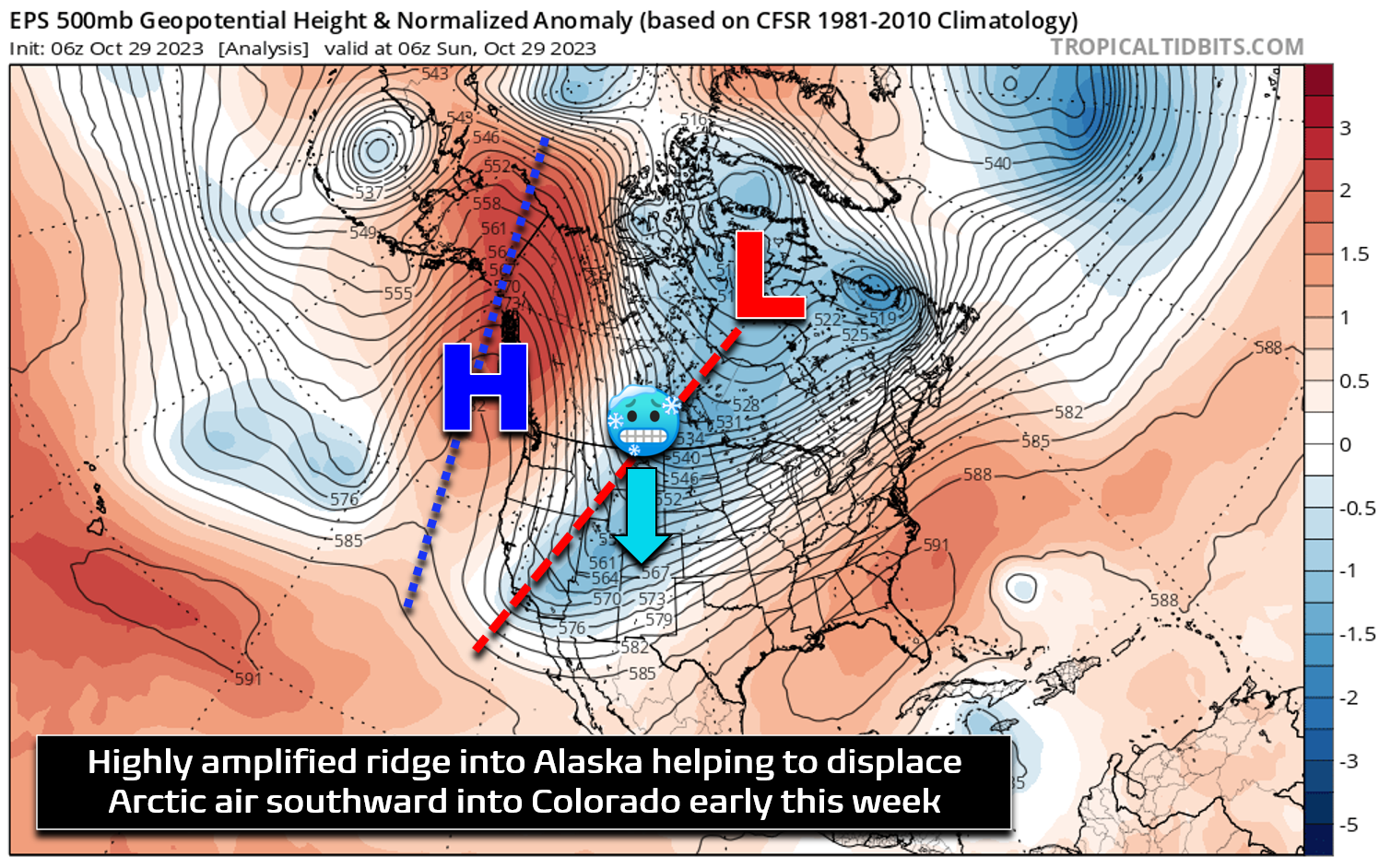
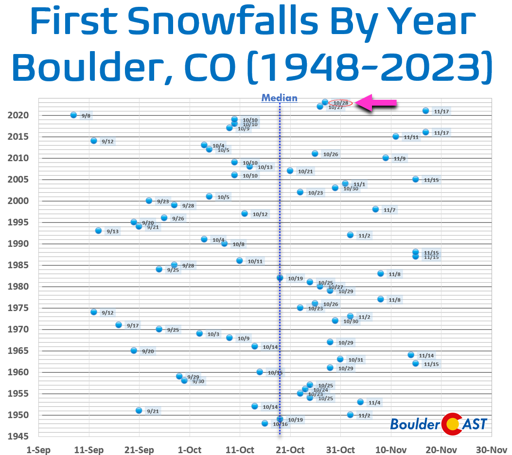
This past weekend saw a bigger-than-usual inaugural snowfall of the season dump on the Front Range with most areas picking up between 5 and 12 inches of white stuff. Alongside the snow, Arctic air has pushed southward into the United States and Colorado — the coldest of the nascent season thus far. Temperatures will end up being below freezing for roughly sixty straight hours with this event after high temperatures only in the 20s both this past Saturday and Sunday. This Arctic outbreak is being fueled by an usually amplified ridge of high pressure over Alaska, an atmospheric setup which causes an opposing amplified flow downstream across the heart of North America. That is, a sharp trough digging southward. This opens the door for very cold airmasses to make it further south than usual. This is a common setup for us during the winter months, particularly during La Niña, and it often leads to some of our most intense cold air outbreaks. One such “Alaskan ridge” occurred almost four years ago to the day back in 2019 and brought record cold with subfreezing temperatures lasting over 100 hours in Boulder!
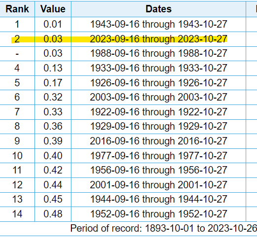
The snow that accompanied the bitter cold was certainly welcomed though — we definitely needed the moisture after having endured more than six weeks of bone dry conditions.
Our snowfall forecast map for this past weekend’s event is shown below with storm totals overlaid. Green values indicate our forecast verified to within one inch. Red did not. Overall the forecast for this mildly impressive first winter storm of the season verified quite well across the board — which we’re certainly happy with considering how difficult the forecast actually was. A few cities came in on the low-end of projections, but just barely, including places like Louisville, Lafayette, Broomfield and Thornton. This was mainly because the heavy snow bands were less widespread and intense than expected across the board. The southern Denver Metro area was always expected to see more snow and they did. There was also very minimal if any indication for higher totals in the Foothills, something we also detailed in our forecast. This storm was almost entirely controlled by the snow band gods — it wasn’t dominated by upslope flow.
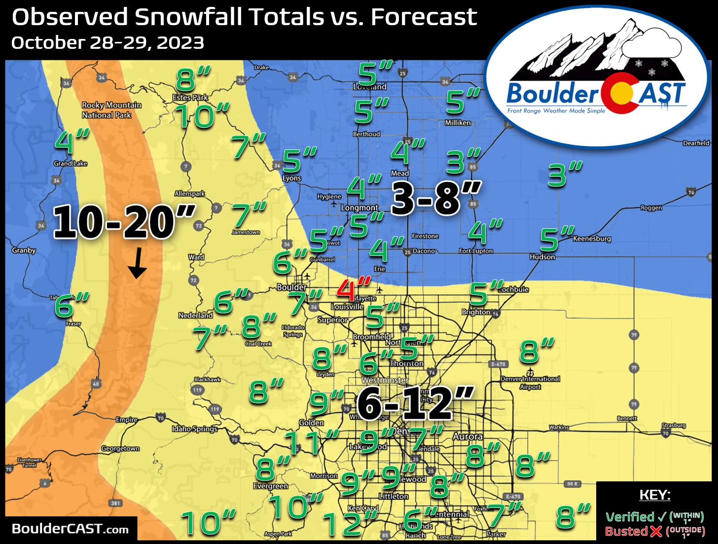
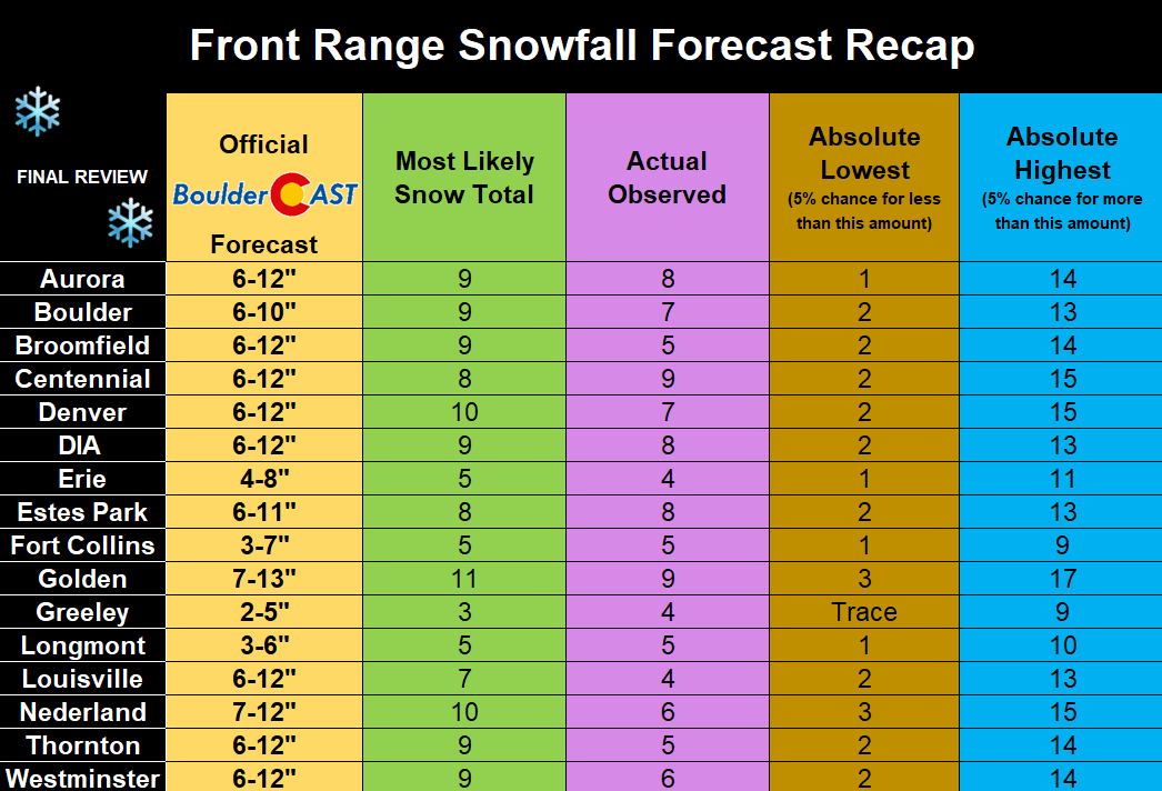
Officially Boulder recorded 6.8″ of snow and Denver (DIA) received 7.5″, a rare snow event where DIA bested Boulder — something that was expected this time around though. The table below is another way to look at the forecast totals and verification for this event for specific Front Range cities. Similarly, this table indicates that most cities came in slightly below their “most likely” snow total for the event. Somewhat disappointing, but a solid first snowfall of the season nonetheless!
With our first snow now having come and gone, be sure to check to see if you were one of the 50 winners in our 2023 First Snow Contest; we announced the cornucopia of winners in a recent post.
A bland week ahead
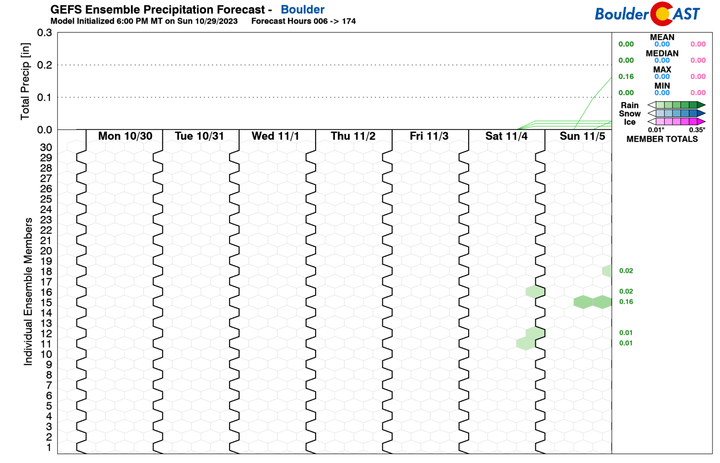
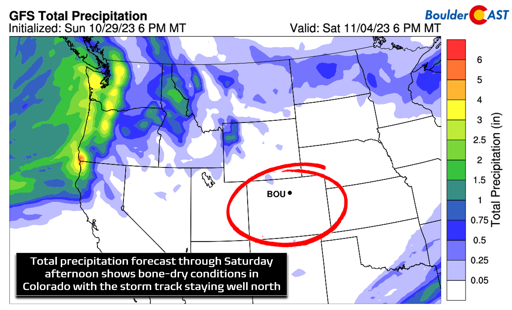
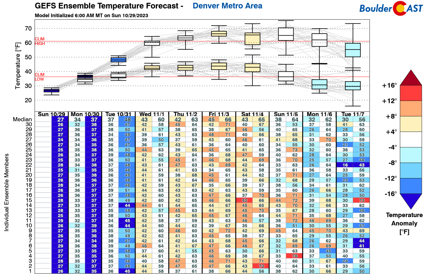
If that first taste of winter was a bit too much for you, we’ve got good news as the rest of the week will be rather uneventful and bland across the Front Range. The GFS ensemble precipitation plume forecast below shows nary a hint of precipitation over the next seven days in Boulder, with a completely dry work-week ahead and only a slight chance of rain for the upcoming weekend.
Statewide precipitation is expected to be next to nil through Saturday:
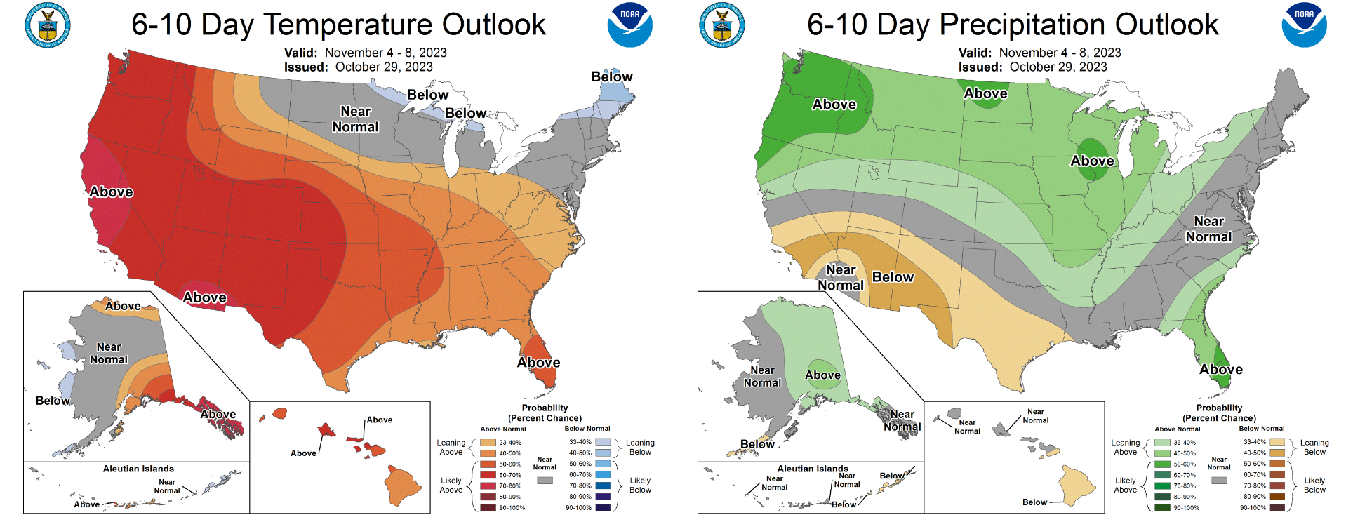
Temperatures will also be trending upwards this week getting back above normal into the 60s by late week.
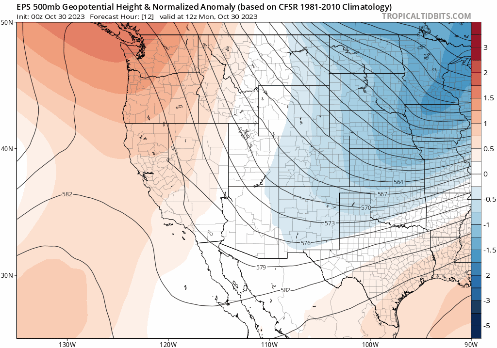
The large scale pattern across the region this week will evolve from a cold Canadian trough towards ridging for Colorado which moves onshore from the west. While the ridge axis never fully reaches our area, at least according to the Euro ensemble forecast below, it will usher in warmer temperatures and downslope flow the rest of the week from the west-northwest. With this, expect temperatures to moderate every day by several degrees (or more in some cases), though the snow on the ground will be dampening the warm-up somewhat. There will also be bountiful sunshine to go around.
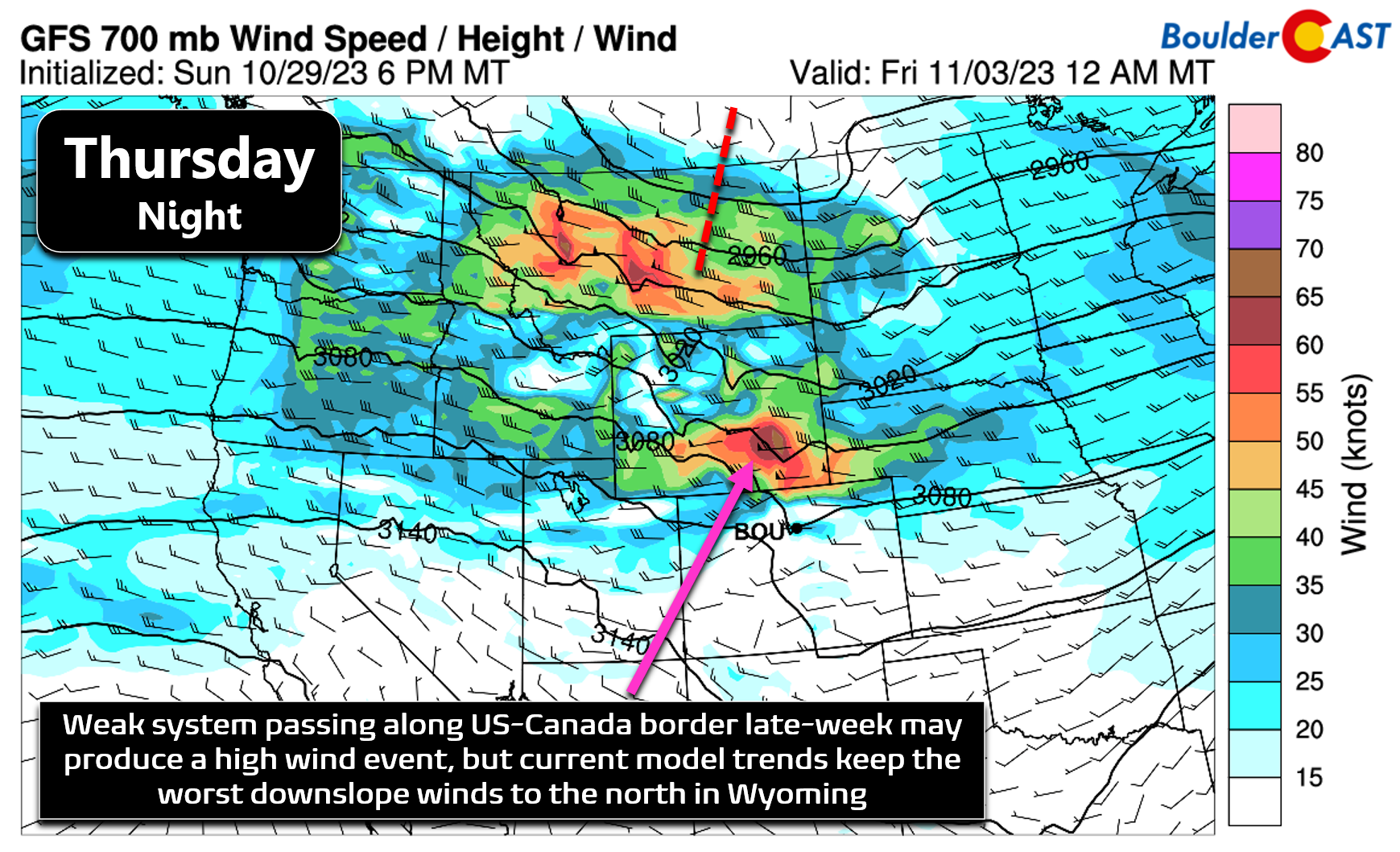
With a lack of any major weather features in the pipeline for us, there’s not too much to be concerned about this week. One thing we are watching is a potential high wind event for late-week around Thursday night. A shortwave is progged to be tracking along the Canadian border at this time with favorable conditions for mountain wave enhancement in the lee of the Rockies. Currently it looks like this setup will miss the Front Range just to the north, but with so much lead time it could end up shifting south a tad. Even if we don’t fully catch this mountain wave late-week, we should see at least a slight uptick in breeziness and wave clouds.
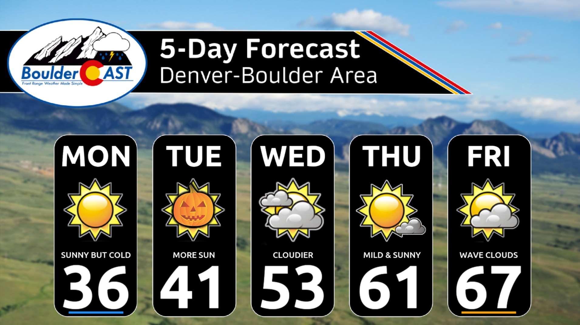
Here’s a look at that five-day forecast — we warned you it would be super bland! Tricker-treaters on Tuesday evening can expect dry but cold conditions as temperatures plummet quickly after sunset into the 30s and even the 20s in outlying areas. Bundle up if planning to be out and about gathering candy or partaking in other holiday activities.
The upcoming weekend looks similarly bland as well, at least compared to this past weekend’s bitter cold and snowy performance. There may be a weak cold front Friday night clipping the area which could cool us off a tad on Saturday (just 5-10°F, if at all). Sunday should rebound back into the middle or upper 60s. Both days will be pleasant and mostly (if not completely) dry.
Enjoy the quiet weather this week — that first snow will be gone before you know it!
From all of us at BoulderCAST, have a safe and happy Halloween!
![]()
Get BoulderCAST updates delivered to your inbox:
Forecast Specifics:
Monday: Sunny and cold with high temperatures only in the 30s across the Plains with 20s in the Foothills.
Tuesday: Staying sunny and slightly warmer with highs reaching the lower 40s on the Plains with lower 30s in the Foothills.
Wednesday: More clouds and warmer. Temperatures top out in the low to middle 50s on the Plains with near 40 degrees in the Foothills.
Thursday: Mostly sunny and mild with temperatures warming further into the lower 60s across the Plains and into the upper 40s in the Foothills.
Friday: Warmer still with more wave clouds around and possibly breezy. Highs reach the middle to upper 60s on the Plains with middle 50s in the Foothills.
Weekend: More of the same, though there will be a weak cold front moving through Saturday which could bring a slight chance of rain and slightly cooler temperatures. Not expecting any major changes for the weekend, though.
DISCLAIMER: This weekly outlook forecast is created Monday morning and covers the entire upcoming week. Accuracy will decrease as the week progresses as this post is NOT updated. To receive daily updated forecasts from our team, among many other perks, subscribe to BoulderCAST Premium.
Go Premium, get all the perks.
Daily Forecast Updates
Get our daily forecast discussion every morning delivered to your inbox.
All Our Model Data
Access to all our Colorado-centric high-resolution weather model graphics. Seriously — every one!
Ski & Hiking Forecasts
6-day forecasts for all the Colorado ski resorts, plus more than 120 hiking trails, including every 14er.
Smoke Forecasts
Wildfire smoke concentration predictions up to 72 hours into the future.
Exclusive Content
Weekend outlooks every Thursday, bonus storm updates, historical data and much more!
No Advertisements
Enjoy ad-free viewing on the entire site.
Enjoy our content? Give it a share!


You must be logged in to post a comment.