The highly anticipated first snowfall of the season is now out of the way for everyone in the Front Range with a widespread blanket of snow having dumped on the area Saturday evening and overnight. Light snow continues to fall Sunday morning, but most of the accumulation is over and done with. Though things didn’t go perfectly as planned, snowfall amounts came in about as expected across the Boulder-Denver Metro area with a range of 3 to 12″. Let’s take a look at the totals and near-term forecast. We also announce the (many) winners of our 2023 First Snowfall Contest.
First snow of the season is in the bag!
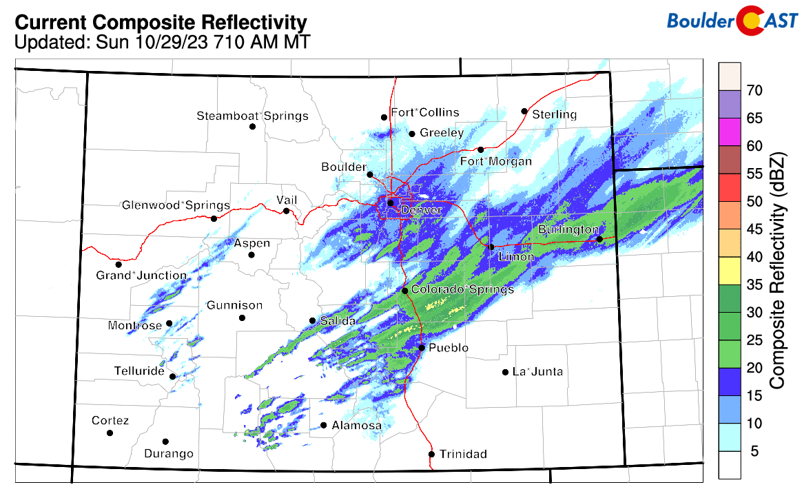
Despite a less than stellar performance by the heavy snow bands Saturday evening, our first snowfall of the season is now behind us with everyone picking up at least several inches of white stuff this weekend. As of 8:00AM Sunday, most of the heavier snow bands have sagged southward across southeast Colorado with just widespread light snow remaining throughout most of the Front Range. There are a few more moderate pockets of snowfall lingering south of Interstate 70 in Denver which could produce another 1-2″ of accumulation there. Elsewhere, 1″ or less of additional accumulation can be expected through Sunday morning before the snow fully tapers off around midday or early afternoon. Roads are slick and snow covered out there as of early Sunday morning, but things should be clearing up nicely in the coming hours.
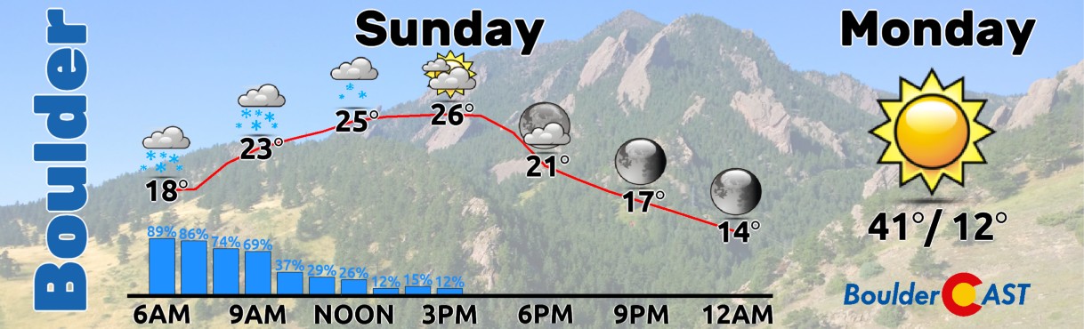
High temperatures will remain bitter cold today, though, only topping out in the middle 20s with perhaps a few peeks of sunshine working in through the clouds later on. As skies clear Sunday evening, the coldest night of the season lies ahead with most of the lower elevations plummeting towards 10°F, with single digits in the Foothills. Brr! Monday temperatures will finally get back above freezing for the first time since Friday evening!
As for snowfall amounts reported so far with this system (keep in mind it will still be snowing lightly for a few more hours), generally we have seen 3-7″ for areas north of Interstate 70 and 6-11″ for areas south of there. The weather models did a great job predicting this storm overall, even many days in advance, but were ultimately off on the location of the best banding by ~25 miles or so. That was always a concern, though, so no surprises there.

Preliminary snowfall amounts ending at ~7:00 AM Sunday. Up to 2″ of snow will fall on top of this amount.
Overall, totals came in about as we had forecast, though slightly on the low end in most cases. The official storm total in Boulder is 5.9″ and counting (as of 7:00 AM Sunday), while Denver International Airport has recorded 6.5″ (as of 6:00 AM Sunday).

CU Snow Table view, ~9:00 AM Sunday morning
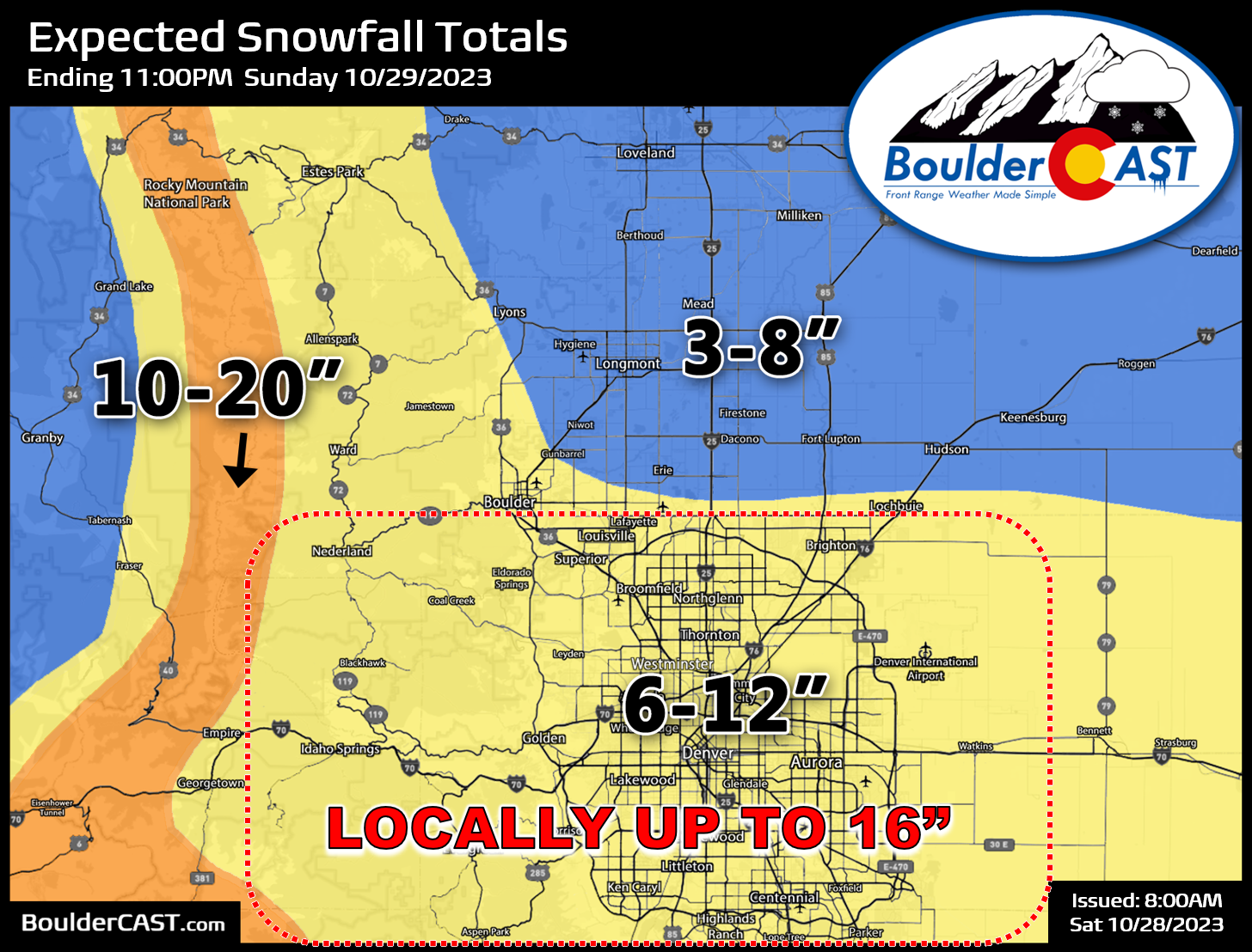
Most of the Front Range will end up within our predicted forecast ranges by the time the snow ceases later on Sunday. If you need a reminder, our final snowfall forecast map provided for this event is shown below. We’ll do the ceremonial verification onto this map once the final totals are in.
That’s all for now. We’ll talk more tomorrow about the quiet and seasonal weather headed our way in our usual Monday morning weekly outlook, so do stay subscribed.
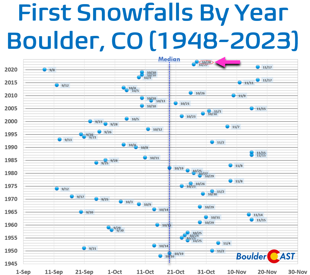
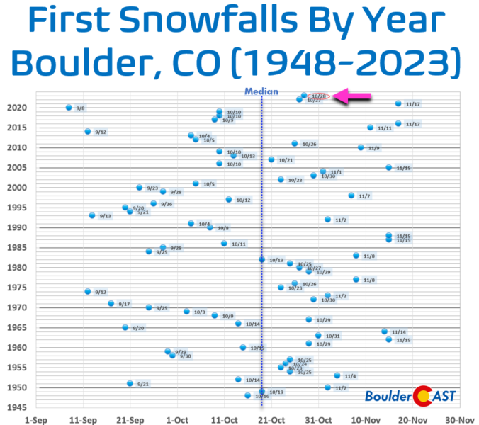
Boulder’s first snowfall in 2023 came one day later than 2022 and about a week later than normal.
BoulderCAST 2023 First Snowfall Contest Results
With Boulder’s first snow of the season officially in the bag, it’s time to announce the winners of our 9th Annual First Snowfall Contest. There were more than 250 entries this year which are summarized in the table below (click to enlarge).
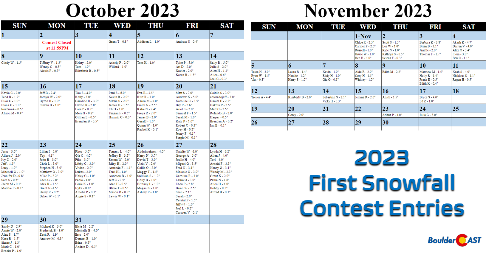
A few notes about the predictions:
- Dates range from October 4th to November 24th
- Amounts range from 0.1 to 7.0 inches
- The median date of the guesses was October 26th. This is about a week later than climatology, perhaps a sign of public sentiment following 2021’s historically late first snow
- The most popular day chosen was October 27th which was selected sixteen times
- 93% of entries predicted a first snow of 4.0 inches or less
The verification of Boulder’s first official snowfall was October 29, 2022 at an amount of 0.6″.
Congratulations to the winners detailed below. Prizes will be sent out via email in the days so do keep an eye on your inbox!
- 1st place: 12-month Premium subscription + $30 Amazon Gift Card
- Bobby (Oct 28 0.3″)
- 2nd place: 6-month Premium subscription + $10 Amazon Gift Card
- Allen H (Oct 28 1.0″)
- Anyone who guessed within 1 day OR 0.1″ correct: 2-month Premium subscription
- Lynda H (Oct 28)
- Allen J (Oct 28)
- Tori (Oct 28)
- Arnold F (Oct 28)
- Nancy G (Oct 28)
- Wendy M (Oct 28)
- Grant K (Oct 28)
- Paula N ( Oct 28)
- Alfred B (Oct 28)
- Natalie W (Oct 27)
- George A (Oct 27)
- Joelle H (Oct 27)
- Miguel G (Oct 27)
- Fred N (Oct 27)
- Melanie O (Oct 27)
- Caroline R (Oct 27)
- Laura O (Oct 27)
- Eben P (Oct 27)
- Brian W (Oct 27)
- Sean (Oct 27)
- Sarah (Oct 27)
- Crystal P (Oct 27)
- Jiffy44 (Oct 27)
- Joel L (Oct 27)
- Carmen V (Oct 27)
- Sandy D (Oct 29)
- Annie W (Oct 29)
- Alex S (Oct 29)
- Kara B (Oct 29)
- Shane J (Oct 29)
- Mark C (Oct 29)
- Brooks P (Oct 29)
- Elizabeth R (0.5″)
- Alice (0.6″)
- treefarm4 (0.5″)
- Gillian L (0.5″)
- Brendan B (0.5″)
- Teagan F (0.5″)
- Harper (0.5″)
- Sam S ( 0.5″)
- Blake T (0.5″)
- Alan H (0.5″)
- Jeff C (0.5″)
- Edna (0.5″)
- Kathryn S (0.5″)
- Gia G (0.5″)
- Frank E (0.5″)
- Regan H (0.5″)
- All other entries: Virtual “pat on the back”
- More than 200 others
If you didn’t win, don’t worry. We’ll definitely host more weather-related contests periodically throughout the year, so do check back or subscribe.
Subscribe to receive email notifications for BoulderCAST updates:
We respect your privacy. You can unsubscribe at any time.
Enjoy our content? Help us out and give it a share:

Go Premium, get all the perks.
Daily Forecast Updates
Get our daily forecast discussion every morning delivered to your inbox.
All Our Model Data
Access to all our Colorado-centric high-resolution weather model graphics. Seriously — every one!
Ski & Hiking Forecasts
6-day forecasts for all the Colorado ski resorts, plus more than 120 hiking trails, including every 14er.
Smoke Forecasts
Wildfire smoke concentration predictions up to 72 hours into the future.
Exclusive Content
Weekend outlooks every Thursday, bonus storm updates, historical data and much more!
No Advertisements
Enjoy ad-free viewing on the entire site.


You must be logged in to post a comment.