The winter storm we’ve been tracking all week long is finally bearing down on Front Range Colorado and forecast confidence is not as high as we’d like this late in the game. We discuss the latest developments, including multiple pathways for a bust east of Interstate 25, and provide our latest snowfall forecast map.
Category: Forecast (Page 82 of 169)
Why are some weather models predicting drastically more snowfall than others? Why does this winter storm seem more predictable than others? How much snow is each member of our team expecting in Boulder? Listen to find out!
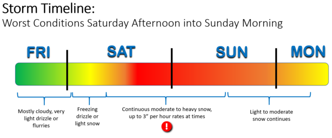
In today’s update we fine-tune the timing of the storm as it is now anticipated to progress more slowly through the region. This has delayed the onset of the snow, but in the end will lead to a longer duration storm. Projected snowfall totals haven’t changed a lot since yesterday, but let’s walk through the latest!
UPDATE (Fri 3/12/21 7:00AM): The recent rounds of model updates continue to support heavy snow this weekend across the Front Range, however snowfall totals have trended downward slightly as models are coming into better agreement. We discuss this and more in Friday morning’s Premium weather discussion, found HERE.
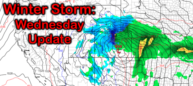
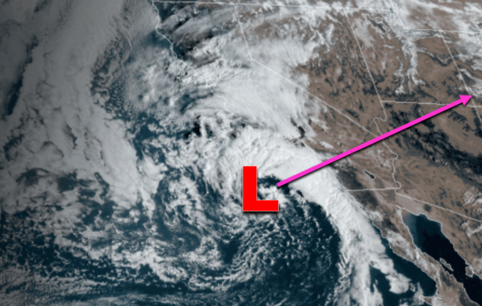
Wednesday Update: Massive snow totals on-track for the weekend, but there’s a few potential problems
A major winter storm is still on-track for the Front Range, but we’ve got a few updates to share with you that could impact which areas see the most snow. We discuss the latest model trends, our thoughts on this historic storm as it stands now, and highlight what to look out for in the days ahead.
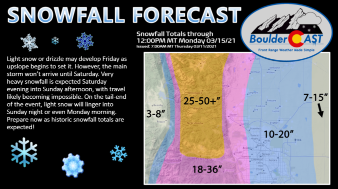
UPDATE (Thu 3/11/21 7:00AM): The recent rounds of model updates continue to support heavy snow this weekend across the Front Range, however the timing has shifted slightly. We discuss this and more in Thursday morning’s Premium weather discussion, found HERE.

The secret is out it seems! By now you’ve heard that a major winter storm is heading towards the Front Range. Some weather models are predicting that historic snowfall totals will blanket the area by the end of the upcoming weekend. While forecast confidence is growing, our storm system is still offshore and the main event is still several days away from Colorado. We discuss the latest on the storm, provide details on how the models are trending, and give our (super early) preliminary snowfall forecast.
UPDATE (Wed 3/10/21 7:00AM): The recent rounds of model updates continue to support heavy snow this weekend across the Front Range, however there are a few concerns we have as the storm approaches. We discuss this and more in Wednesday morning’s Premium weather discussion, found HERE.

The week ahead will certainly be a wild one! There will be warm temperatures to begin on Monday and Tuesday, but we’ll be trending colder and unsettled thereafter. This transition is just the tip of the iceberg, though, with a potentially massive winter storm gearing up for the weekend ahead. Let’s talk about this roller-coaster of weather knocking on our door.
It sure has felt like spring the last few days, but Mother Nature will remind us soon that is it very much still winter on the calendar. Warm sunshine will be replaced with thick clouds, cold rain and ultimately wet snow on Thursday. The incoming storm is lacking truly cold air, but it will have just enough for most of us (but not all of us) to see a little snow. Let’s take a look at how the first “warm” storm of 2021 will play out across the Front Range!
UPDATE (Thu 3/4/21 7:00AM): With temperatures being so marginal, uncertainty lingers in regards how much precipitation will fall and who will see accumulating snow from the storm. We discuss this and more in this morning’s Premium weather discussion, found HERE.

The first full-week of March starts out with temperatures on the up-and-up! Highs will rise well into the 50’s by midweek as a dome of high pressure settles into the Intermountain West spelling out above average temperatures for the Front Range. A late-week southern storm system will bring a chance of snow to the Mountains and rain/snow to the lower elevations.

Live View of Boulder

Current Conditions

Live Radar

Latest Smoke Forecast

Recent Premium Posts

BoulderCAST Daily – Wed 07/15/26 | The Ridge Rules the Rockies as Hot, Dry Pattern Holds Firm
🔥 Heat dome setup continues — A strong, stationary 500 mb ridge keeps …
BoulderCAST Daily – Tue 07/14/26 | The Front Range Continues to Bake Under Expansive Ridge
🔥 Heat streak continues — Boulder hit 97°F for the third time in …
BoulderCAST Daily – Sun 07/12/26 | Hot weather for a good chunk of the coming week
🥵 🔥 Heat for a good chunk of the week: Upper 90s through …
3-Day Forecast

Trending Content

© 2026 Front Range Weather, LLC