
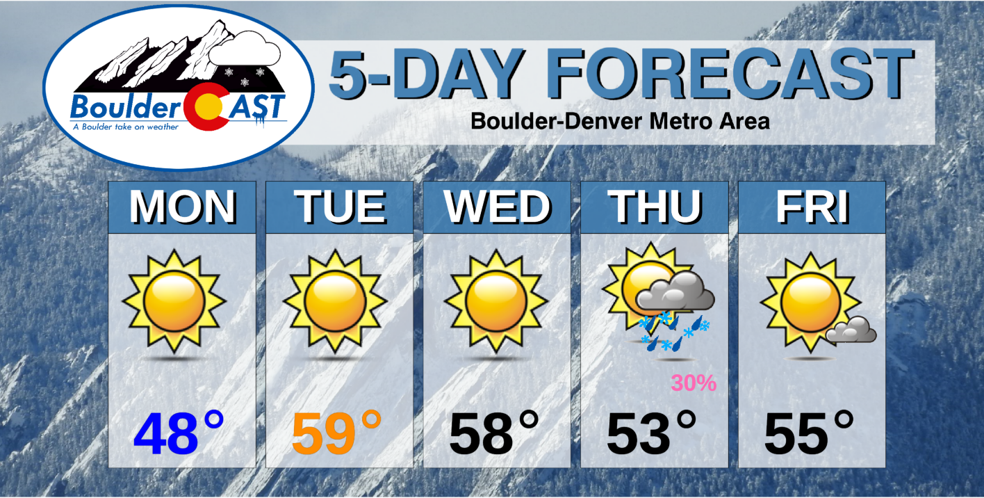
The first full-week of March starts out with temperatures on the up-and-up! Highs will rise well into the 50’s by midweek as a dome of high pressure settles into the Intermountain West spelling out above average temperatures for the Front Range. A late-week southern storm system will bring a chance of snow to the Mountains and rain/snow to the lower elevations.
This week’s highlights include:
- Our snowfall melts quickly these next few days as high pressure pushes temperatures well into the 50’s
- Later in the week a southern-track system brings a chance of precipitation, but looks to be mainly rain for the lower elevations
- Heading into the weekend with above normal temperatures
DISCLAIMER: This weekly outlook forecast is created Monday morning and covers the entire upcoming week. Accuracy will decrease as the week progresses as this post is NOT updated. To receive daily updated forecasts from our team, subscribe to BoulderCAST Premium.

Snow melts as warmth ensues through midweek
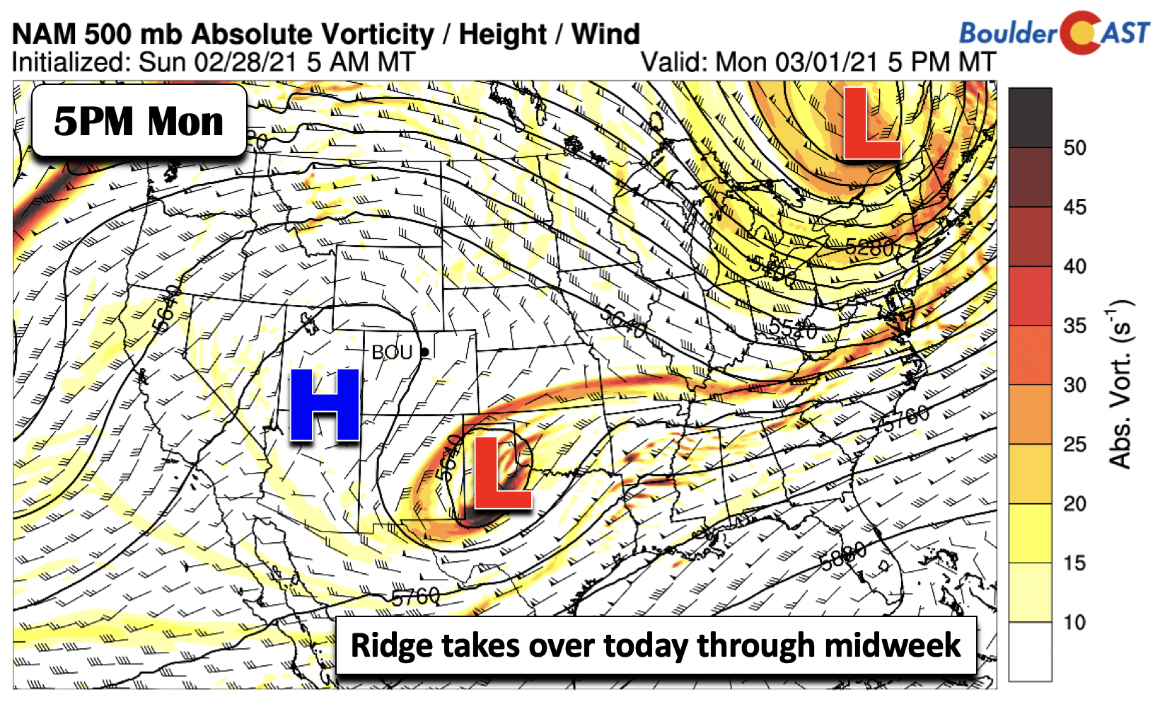
Finally some warmth in store for the Front Range! Before we discuss that, let’s take a look at what’s happening across the nation in the figure below. High pressure ridging is starting to take over, currently centered over southern Utah. Meanwhile, a cut-off low pressure system over the Texas panhandle will continue to move east and away from our area, making its way into the southeastern U.S. by midweek. It is this high pressure ridge in Utah that will dictate the start of March for us.
As the aforementioned high pressure ridge over Utah makes its way eastward today and tomorrow, pleasant downslope warming will take effect for the Front Range. The airmass today warms some 6°C in the low-levels relative to Sunday, where we saw upper 30’s for highs in the Denver Metro yesterday. Even though there is still a blanket of snow cover on the ground, mid to upper 40’s appear quite likely with lots of sunshine Monday afternoon alongside light winds.
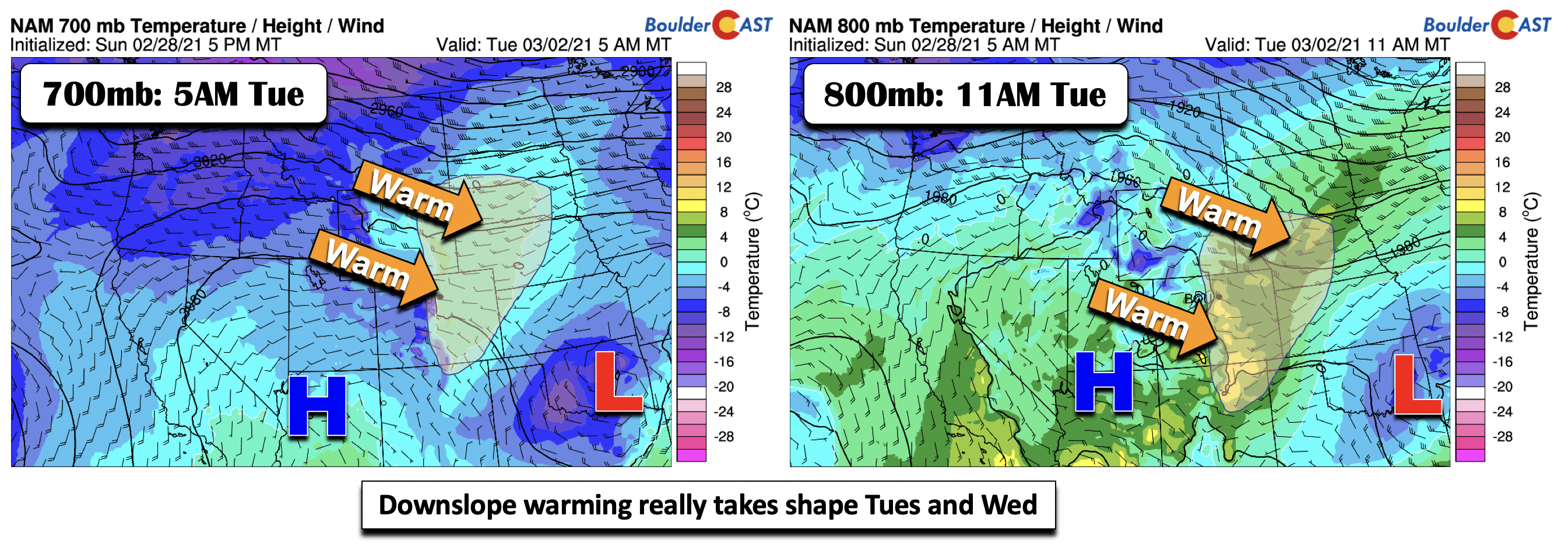
The real “heatwave” comes Tuesday and Wednesday. The downslope warming shows up very nicely in the mid-levels (below left) and the low-levels (below right) early Tuesday. Notice the shaded regions in both graphics, denoting a clear warming of the airmass as sinking air east of the Divide bumps up our temperatures. The region will be quite warm both days. With lots of sunshine again expected, mid to upper 50’s are likely. Heck, we would not be surprised if some locations push into the lower 60’s, although there may still be some snow cover to contend with to keep temperatures in check.
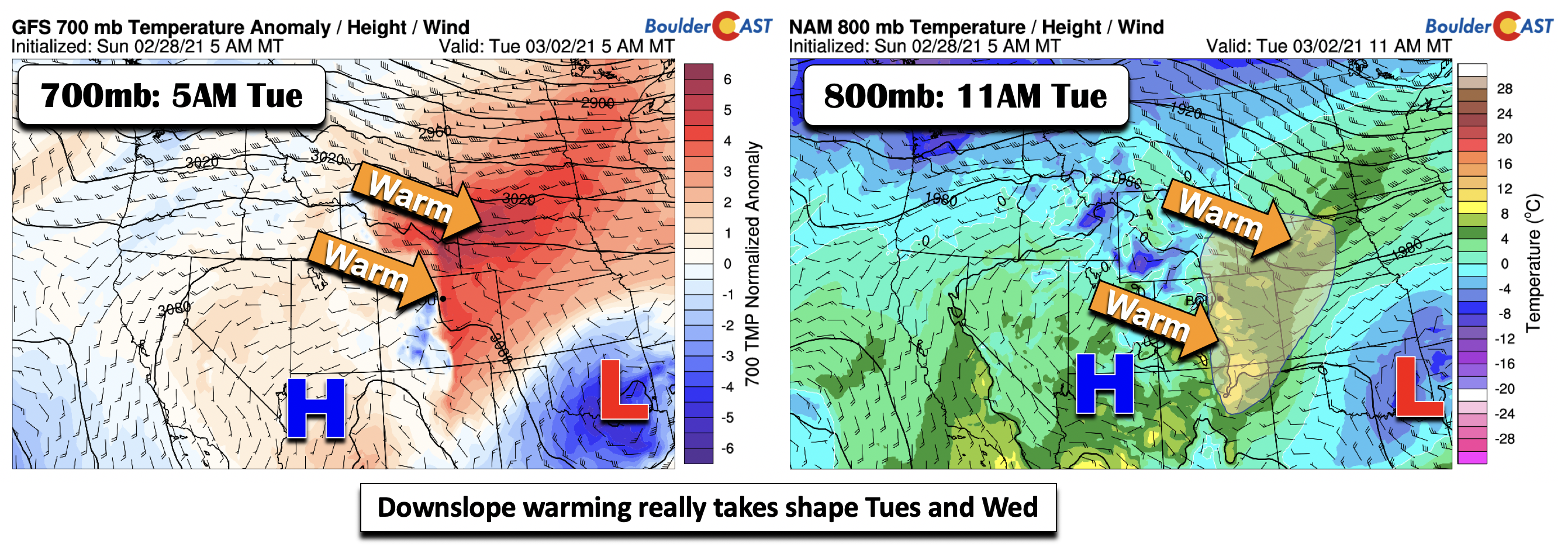
Another way of visualize the warmth is to examine the temperature anomalies (below left) for the same time period, which clearly shows the milder temperatures (red shading) pushing into the Plains with the downslope warming. Quite impressive to say the least!
Late-week southern system increases precipitation chances
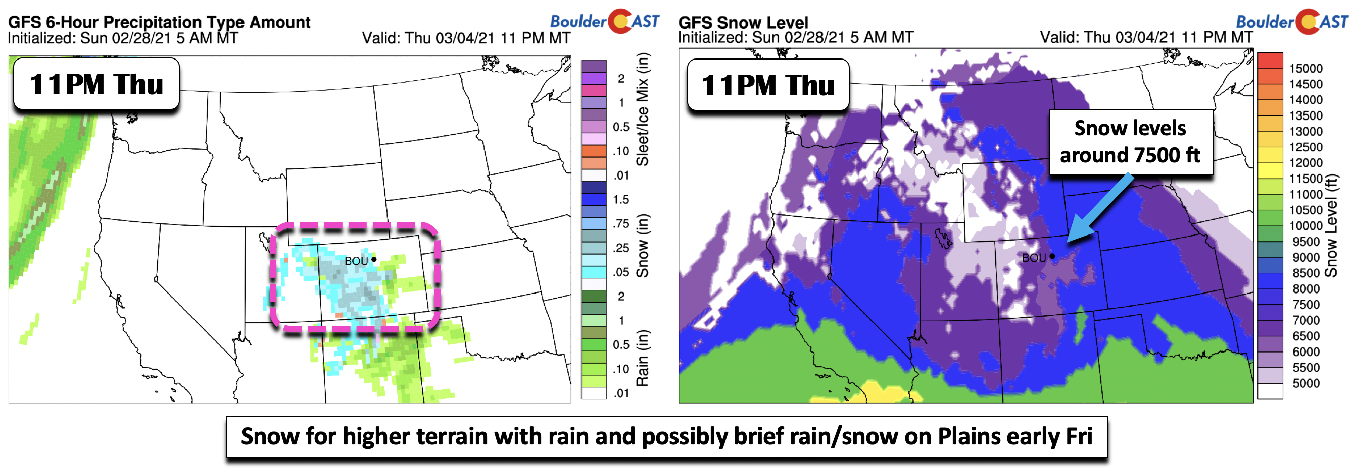
While the late-week weather will not be that bad, there is a decent probability that unsettled weather could ensue late Thursday into early Friday with a southern-track cut-off low pressure system. This time, the low approaches from the southwest after moving inland into California on Wednesday. The ensemble guidance and global models are in modest agreement that this system will traverse along the Colorado/New Mexico border, although the Euro model is a tad further south – which might mean its impacts to us are more minimal than what the GFS would suggest. The GFS (below left) shows abundant moisture pumping in from the south. However, what would normally be a potential snow threat looks like it would mainly be rain across the Denver Metro area, barring any significant changes in the forecast. The reason for that is the airmass is fairly warm in the low and mid-levels. The approximate rain/snow line (below right; dashed blue line) is north of Denver and even extends into Wyoming.

In addition, the forecast snow levels start out around 7,500 feet Thursday night (below right) with temperatures above freezing. The mountains will likely see snow (below left), but the question remains whether it would be an all rain scenario or rain with rain/snow on the tail end for the Plains. We are not too sold that we would see any snow if the system does track as far north as the GFS, but we can’t rule it out given the ensembles hinting at some brief rain/snow mix early on Friday as cooler air filters down from the north. It bears watching but we don’t expect any major surprises with this one. In fact, as with any southern-track system, it could miss us all together and dip even further south. As a result of this weather-maker, temperatures Thursday and Friday stay mild but dip closer to a few degrees above average in the lower to middle 50’s.
Forecast Specifics:
Monday: Sunny and warmer with highs in the mid to upper 40’s on the Plains and middle 30’s in the Foothills.
Tuesday: Sunny and much warmer with upper 50’s for the Plains and middle 40’s in the Foothills.
Wednesday: A few passing clouds, otherwise sunny and still mild with upper 50’s to near 60 on the Plains and middle 40’s in the Foothills.
Thursday: Possibly some morning but, but increasing clouds with a chance of late-day rain on the Plains with snow in the higher Foothills. Rain could mix with snow Thursday night with little to no accumulations expected in the Denver Metro area. Temperatures in the lower 50’s on the Plains and upper 30’s in the Foothills.
Friday: A slight chance of lingering light rain/snow in the early morning, then mostly sunny with highs in the 50’s on the Plains and upper 30’s in the Foothills.
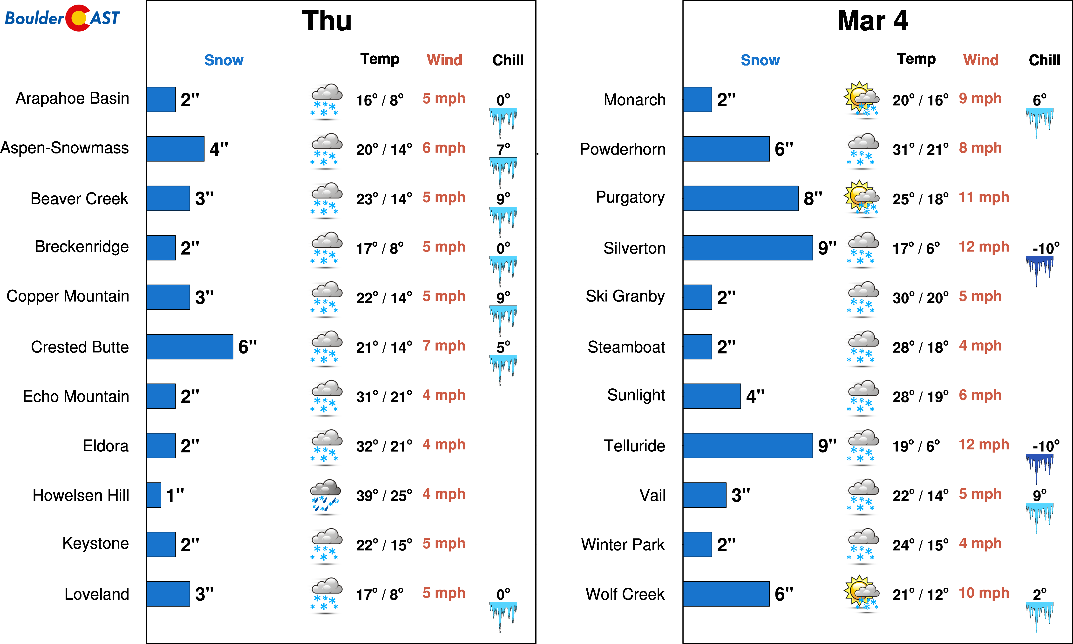
Mountains: A dry period for the High Country through Wednesday. A southern system brings a chance of snow on Thursday and early Friday with the San Juans and Sangres favored most due to the track of the storm.
Help support our team of Front Range weather bloggers by joining BoulderCAST Premium. We talk Boulder and Denver weather every single day. Sign up now to get access to our daily forecast discussions each morning, complete six-day skiing and hiking forecasts powered by machine learning, first-class access to all our Colorado-centric high-resolution weather graphics, bonus storm updates and much more! Or not, we just appreciate your readership!
.
Spread the word, share the BoulderCAST forecast!
.


You must be logged in to post a comment.