It sure has felt like spring the last few days, but Mother Nature will remind us soon that is it very much still winter on the calendar. Warm sunshine will be replaced with thick clouds, cold rain and ultimately wet snow on Thursday. The incoming storm is lacking truly cold air, but it will have just enough for most of us (but not all of us) to see a little snow. Let’s take a look at how the first “warm” storm of 2021 will play out across the Front Range!
UPDATE (Thu 3/4/21 7:00AM): With temperatures being so marginal, uncertainty lingers in regards how much precipitation will fall and who will see accumulating snow from the storm. We discuss this and more in this morning’s Premium weather discussion, found HERE.
At a Glance:
- An warmer, more moisture-rich storm will track from southern California into southern Colorado by Thursday evening
- Rain will develop during the day Thursday, but will mix with and change to snow in most locations
- Higher elevations and southern suburbs will do best, northern cities will do worst
- Precipitation ends Thursday night, with anywhere from 0 to 4″ of snow expected across the Denver Metro area
Help support our team of Front Range weather bloggers by joining BoulderCAST Premium. We talk Boulder and Denver weather every single day. Sign up now to get access to our daily forecast discussions each morning, complete six-day skiing and hiking forecasts powered by machine learning, first-class access to all our Colorado-centric high-resolution weather graphics, bonus storm updates and much more! Or not, we just appreciate your readership!

Spring is in the air…or is it?
While there are nearly three weeks still remaining in the winter season, spring is definitely in the air this week! We hit a high temperature of 63°F on Tuesday at BoulderCAST Station. Not to be outdone, though, today will be similar if not a degree or two warmer. These warm temperatures are accompanied by bluebird skies, solidifying those spring-like feels to kick off the month of March!
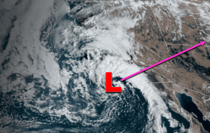
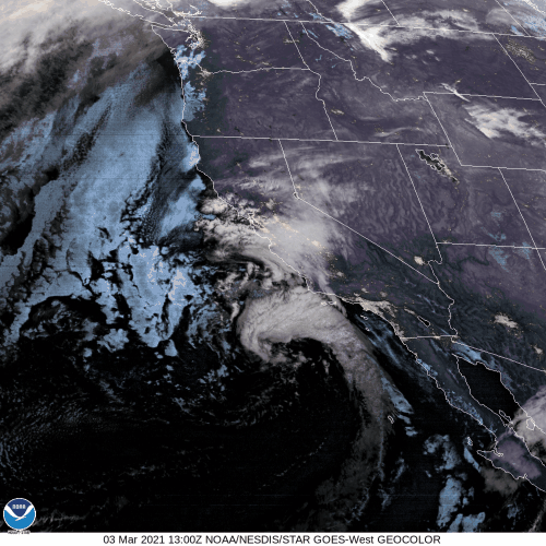
The only forecast concern this week, which we discussed in our weekly outlook, focuses around an approaching “warm” storm system from southern California. It hasn’t quite come ashore yet as of mid-day Wednesday, but the view from GOES-West is impressive nonetheless!
This beautiful low pressure will move inland today and push across southern Colorado on Thursday resulting in an influx of warm and moist air to the Rocky Mountain State. Fun fact: This will be the first southern-track storm to reach the Front Range in about five weeks. The last one produced 1 to 3″ of snow across the Metro area back in late January. Of course, this trend is expected. Warm and wet low pressure systems approaching from the southwest are not very common during La Niña winters.
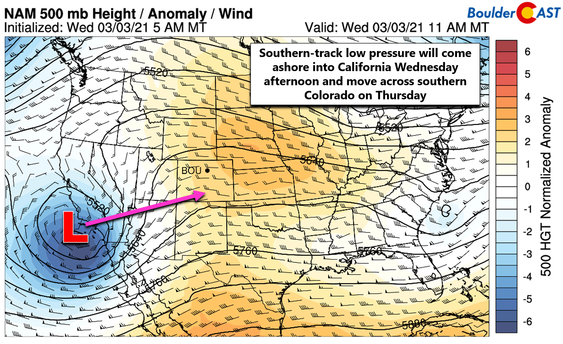
As the storm nears, moisture and warmer air will be drawn northward into the southwestern United States, with widespread cloud cover and precipitation expected across our entire state. Rain and snow will begin in southwestern Colorado late Wednesday night, spreading north and east during the day Thursday.
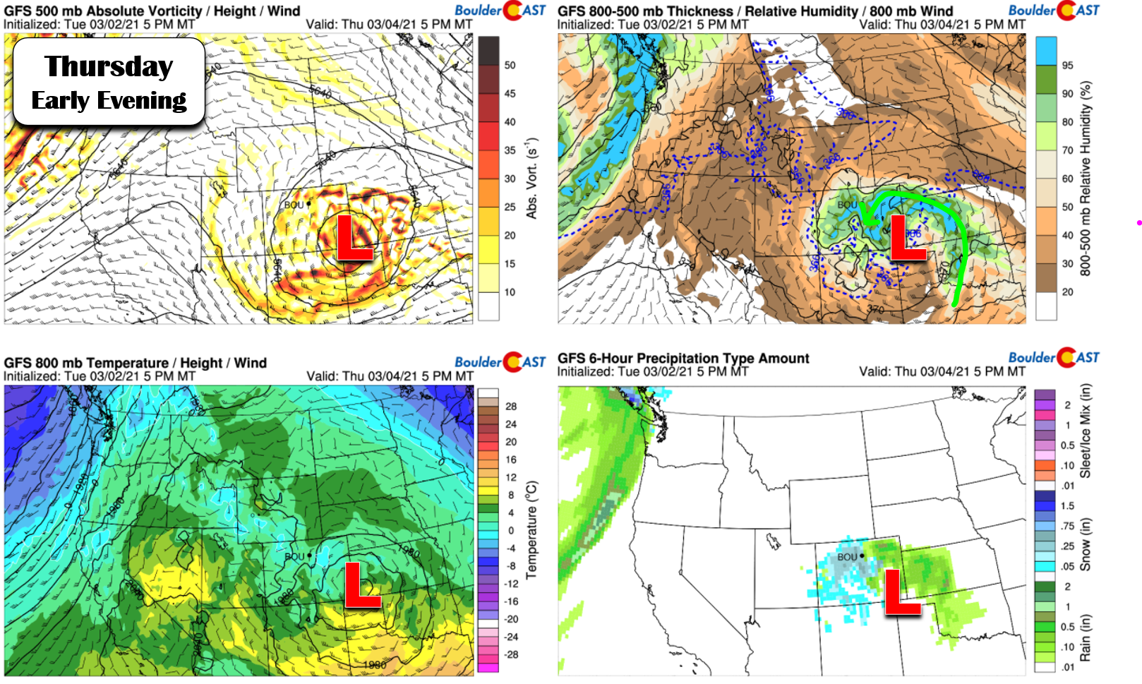
This time the low pressure is actually taking a decent track for us, with good lift and moisture lining up well across the Metro area Thursday afternoon and evening. The top right graphic above really shows the moisture wrapping back into the core of the low pressure Thursday evening.
This all sounds great right? It is, but there’s a catch! There’s not a lot of cold air to work with. Most of the sensible change to our temperatures on Thursday will be due to the thick cloud cover, not a true cold front. The additional cooling from precipitation falling into Colorado’s well-known dry air is what will push some areas from rain over to snow. However, winds in the lower atmosphere will be northerly in the Denver Metro area during the duration of the storm, mostly because the low pressure is just a bit far away. Without any significant easterly component to the flow, this northerly direction will produce downslope into the Denver Metro area from the Cheyenne Ridge. This weak downslope produced by due northerly flow can cause 1 to 4°F of warming in the northern Front Range cities like Fort Collins, Greeley, and Loveland.
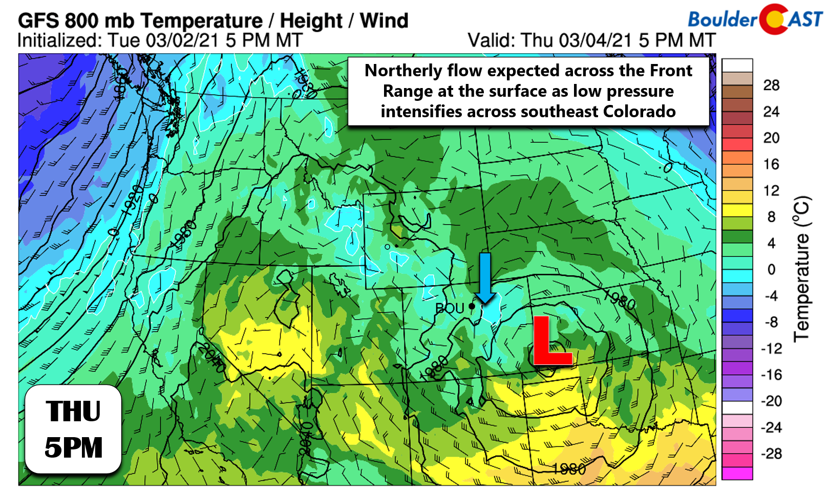
This is the first time in a while that we’ll have to deal with this facet of Front Range topography potentially spoiling a snowstorm. Our long-time readers should be very familiar with the Cheyenne Ridge though… For most mid-winter snow events, this slight downslope warming doesn’t make a difference. However for warmer spring storms, it can prevent rain from changing to snow in northern portions of our area. Yes it’s early March, but this has all the makings of a spring storm, albeit a quick-moving one on the weaker end of the spectrum!
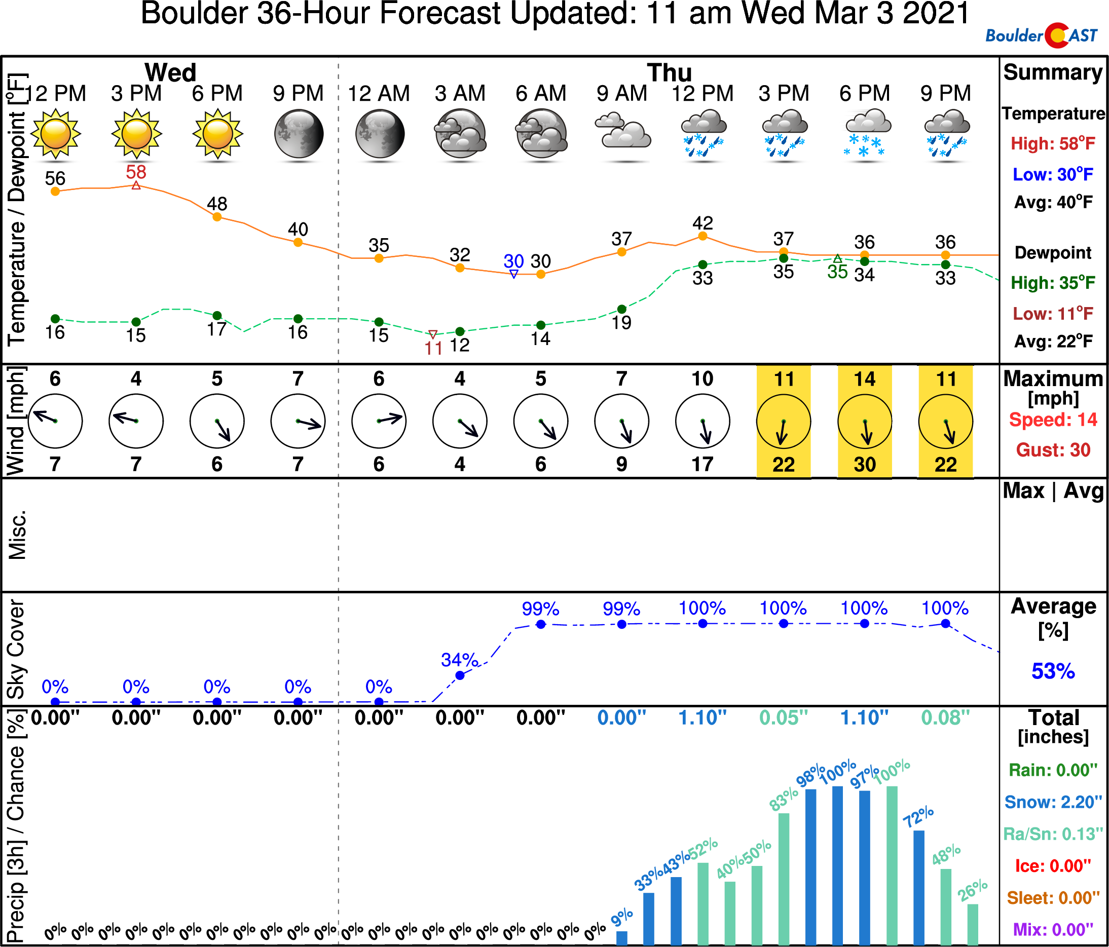
Temperatures will only top out in the lower 40’s on Thursday around mid-day. Spotty rain showers will develop late morning into early afternoon, before becoming fairly widespread through the afternoon and into evening. As temperatures cool slightly into the middle 30’s and stronger lift and instability arrives, most of the Boulder-Denver area will have some snow mixing in with the rain. In the heavier convective cells, it will be all snow and there could even been some claps of thunder to boot! Here’s the latest timeline for Boulder: A cloudy morning, then a mix bag of rain/snow the rest of the day. Yuck!
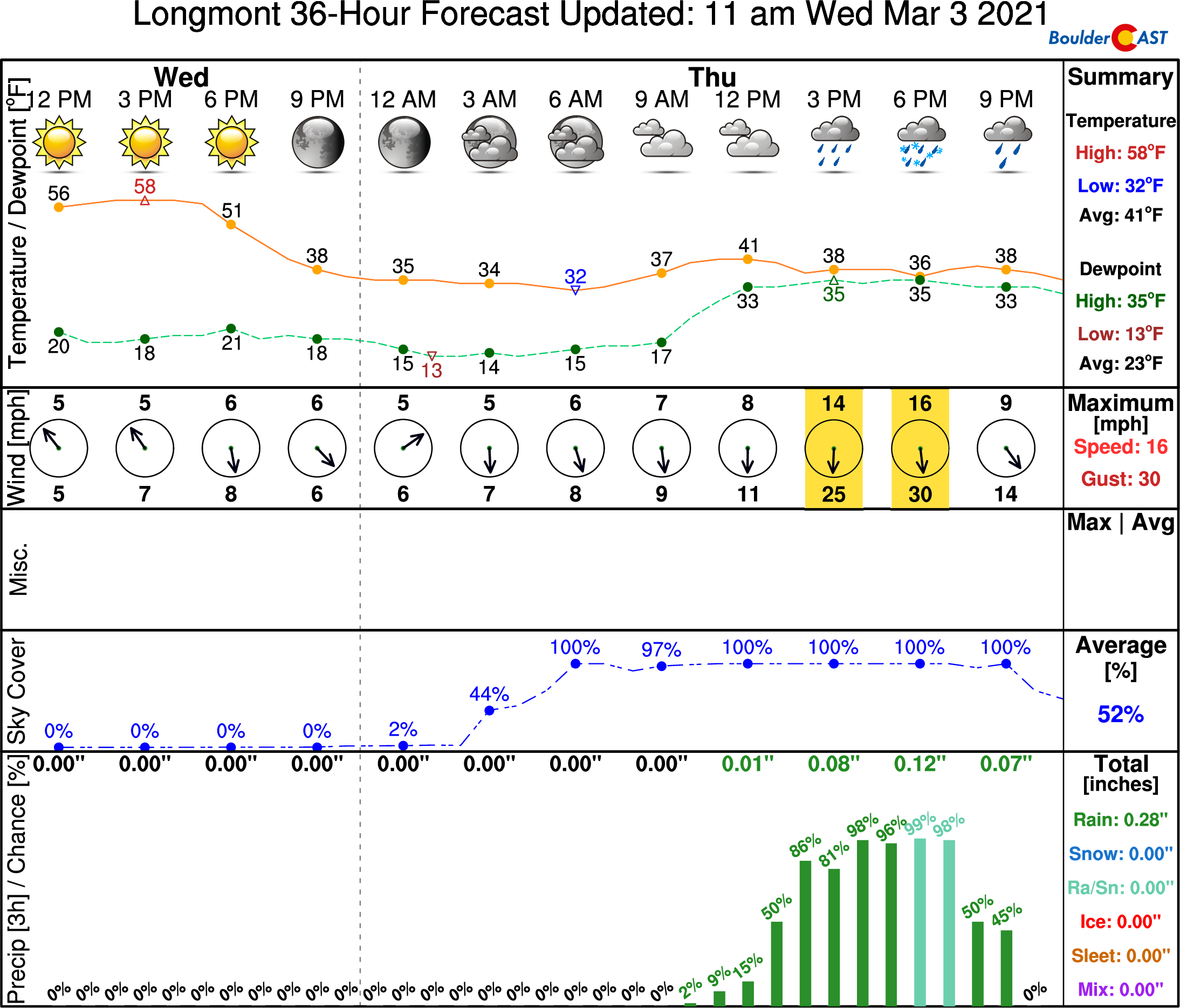
A little further north, expect more rain and less (or perhaps no) snow. Here’s the timeline for Longmont:
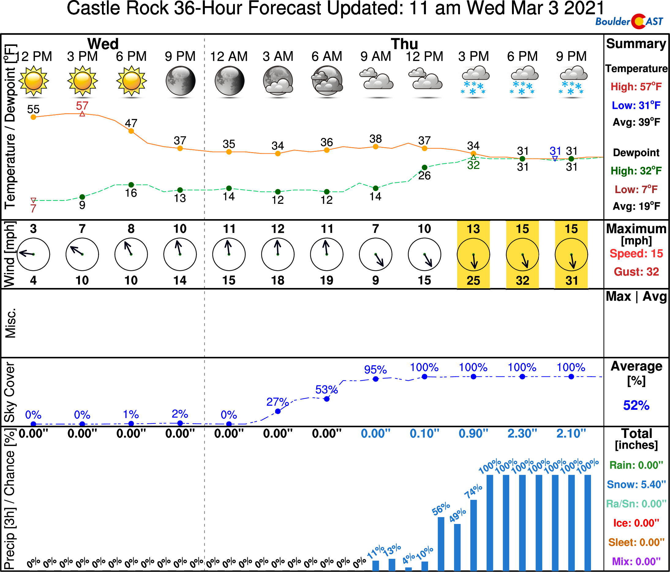
Further south, we’re expecting more snow, particularly into the Palmer Divide where northerly flow is indeed upslope and temperatures will be a little cooler at the slightly higher elevations. Castle Rock could do pretty good on snow from this event:
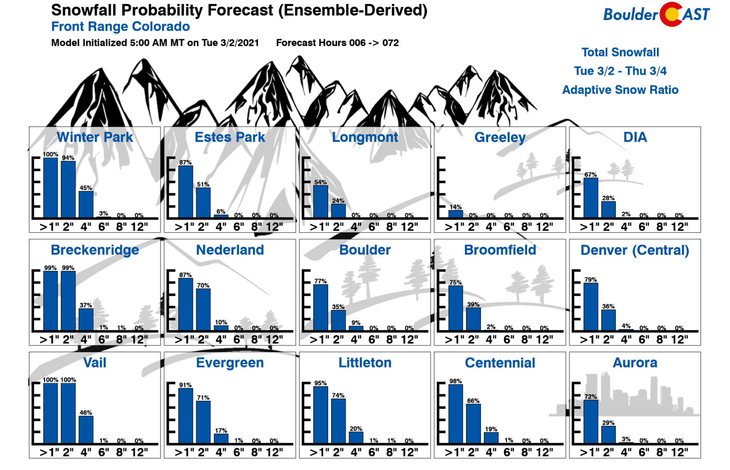
Our Snowfall Probabilities should make it clear: if you want to see an inch or three of wet snow Thursday, you either need to go south or up (in elevation)! This is the case for many a spring storm in the Front Range.
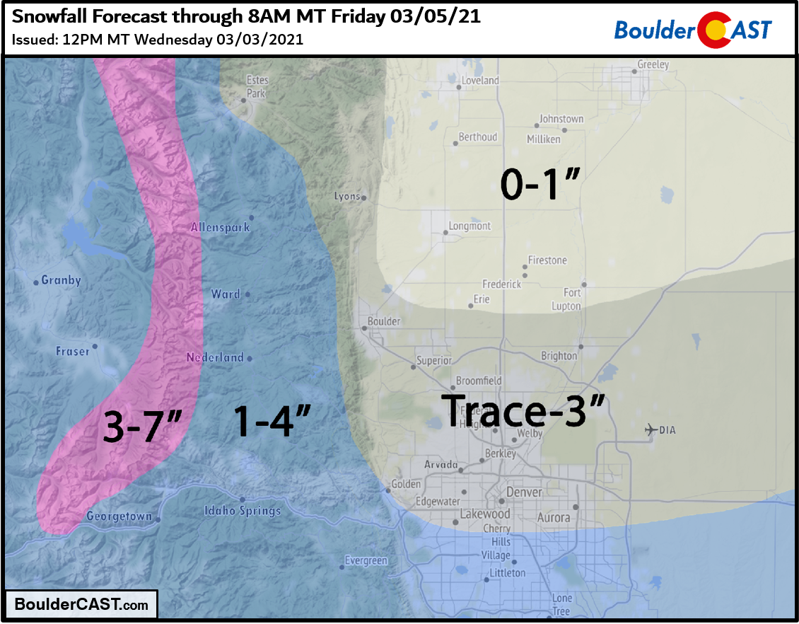
Our snowfall forecast map for the event is shown below. This covers any snow falling through the day Thursday into Thursday night. As you can see, this isn’t a major snowstorm by any means. For some northern areas, it may not even be a snowstorm at all.
A few days of 60’s before the snow starts and the above-freezing temperatures while it’s falling should keep the Denver/Boulder roadways just wet and at worst a little slushy in spots. Watch out along the I-70 passes and especially heading along I-25 south over the Palmer Divide. The snow that sticks across the lower elevations will be very wet and confined to grassy and elevated surfaces…or surfaces still blanketed by the foot of snow from last week.
We’ll continue to monitor the evolving forecast leading up the event on Thursday and post updates as needed. Should things trend a little colder than our expectations, totals would shift to the upper-end of our forecast ranges. A little warmer? You know that result. As we always say, moisture is moisture. Solid or liquid, in Colorado we must take whatever we can get. Happy Wednesday!
Get BoulderCAST weather updates delivered to your inbox!
We respect your privacy. You can unsubscribe at any time.
Help support our team of Front Range weather bloggers by joining BoulderCAST Premium. We talk Boulder and Denver weather every single day. Sign up now to get access to our daily forecast discussions each morning, complete six-day skiing and hiking forecasts powered by machine learning, first-class access to all our Colorado-centric high-resolution weather graphics, bonus storm updates and much more! Or not, we just appreciate your readership!
.
Spread the word, share the BoulderCAST forecast:
.


You must be logged in to post a comment.