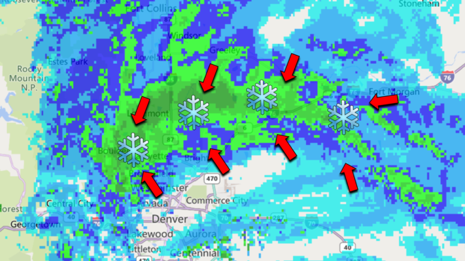
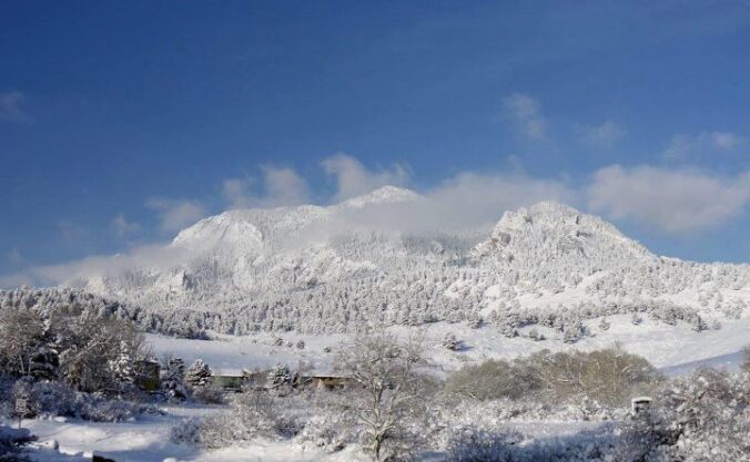
About half of the Front Range received snowfall right in line with our forecast last night, while the other half saw incredible snowfall amounts of a foot or more! What caused such an explosion of heavy snow in the heart of Denver last night? Let’s take a look.
Category: Forecast (Page 83 of 169)
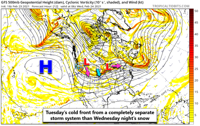
The weather models by and large are coming into a slightly snowier agreement this afternoon. We provide a quick update as winter weather bears down on the Front Range, including our final snowfall forecast map with totals adjusted upwards in many locations.
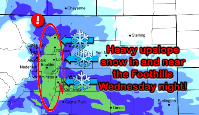
It’s been a glorious start to the week so far with highs getting back above normal on Monday and Tuesday. Even though it was quite breezy at times, temperatures flirting with 60 degrees took the chill right out of the wind. The stretch of fair weather changes very soon as two cold fronts and a taste of winter weather bear down on Colorado. A widespread, upslope-driven snowfall event is gearing-up for Wednesday evening into Thursday. Let’s take a look at the timing and snowfall amounts expected across the Front Range!
UPDATE (Wed 2/24/21 7:00AM): Updated snowfall forecast map, fine-tuning amounts and the position of the expected sharp gradient. Details of these changes are included in Wednesday morning’s Premium weather discussion, found HERE.
The nicest weather in nearly three weeks will unfold Monday and Tuesday, but snow is just a few days away! Yet another wintry system with an unfavorable track will impact the area Wednesday evening into Thursday bringing widespread upslope snow to the Front Range. We’re also watching the potential for a more significant winter storm during the upcoming weekend, but uncertainty remains this far out. Read on for our complete outlook of the week ahead.
Another day, another chance of light snow. The theme of this winter continues as a weak storm system blazes across Colorado Saturday evening bringing a chance of snow to the region. We’ve got some jet-forcing to deal with this time, so localized bands of heavy snow are possible, but our forecast keeps most of these south and east of Denver. Let’s take a look at the timing and snowfall amounts!
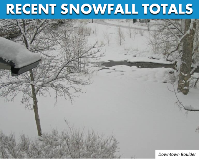
Finally, we got more snow than south Texas and Louisiana! The atmosphere was primed for an explosion of snow Wednesday evening in the Foothills and western Denver Metro area and it did not disappoint this time. Favorable conditions for convective heavy showers for a short window yesterday produced up to a foot of snow in some areas. Let’s take a quick look back at the setup and snowfall totals from across the region.
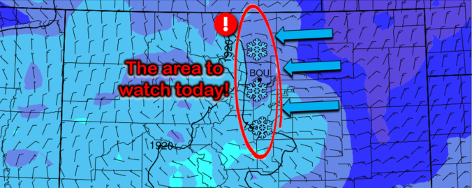
An intriguing weather setup is developing today that will bring a high likelihood of scattered heavy snow showers to the Front Range Wednesday afternoon and evening. The focus will be across the western Denver Metro area, but everyone stands a chance at some snow. We discuss potential snowfall amounts and the impacts to the Wednesday evening commute.
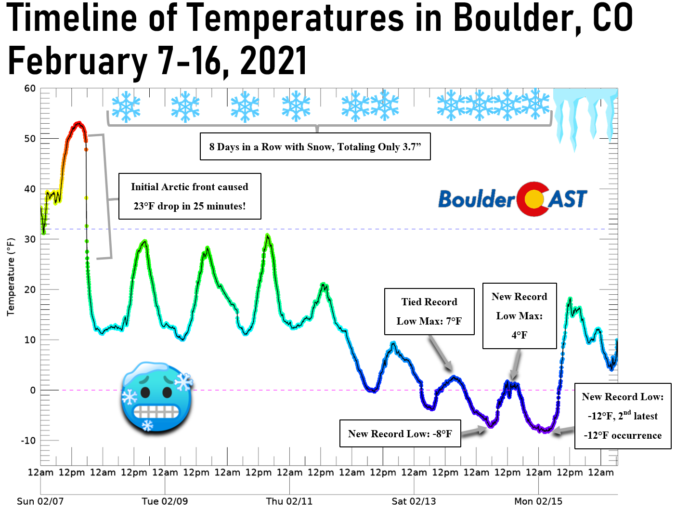
No one fully expected the Arctic airmass that arrived last Sunday evening, a solid nine days ago, to remain entrenched across the Denver Metro area for this long…but it did! We take a look back at the series of events as they unfolded over the last week, including the first regional wildfires of 2021, two dollops of light snow and the coldest temperatures for our area since 2014.

Live View of Boulder

Current Conditions

Live Radar

Latest Smoke Forecast

Recent Premium Posts

BoulderCAST Daily – Wed 07/15/26 | The Ridge Rules the Rockies as Hot, Dry Pattern Holds Firm
🔥 Heat dome setup continues — A strong, stationary 500 mb ridge keeps …
BoulderCAST Daily – Tue 07/14/26 | The Front Range Continues to Bake Under Expansive Ridge
🔥 Heat streak continues — Boulder hit 97°F for the third time in …
BoulderCAST Daily – Sun 07/12/26 | Hot weather for a good chunk of the coming week
🥵 🔥 Heat for a good chunk of the week: Upper 90s through …
3-Day Forecast

Trending Content

© 2026 Front Range Weather, LLC