In an almost identical setup to what transpired this past Monday, another weak storm system will progress across Colorado Thursday night into Friday afternoon. Once again the storm’s track and speed will greatly limit snowfall potential in the Denver Metro area. However, there will be a sprinkle of accumulation to close out the week in some locations. Let’s quickly take a look.
At a Glance:
- Another weak storm arrives Friday with a chance of snow for the area
- Upslope will be coming from the north-northeast direction, which favors the Palmer Divide and southern Foothills
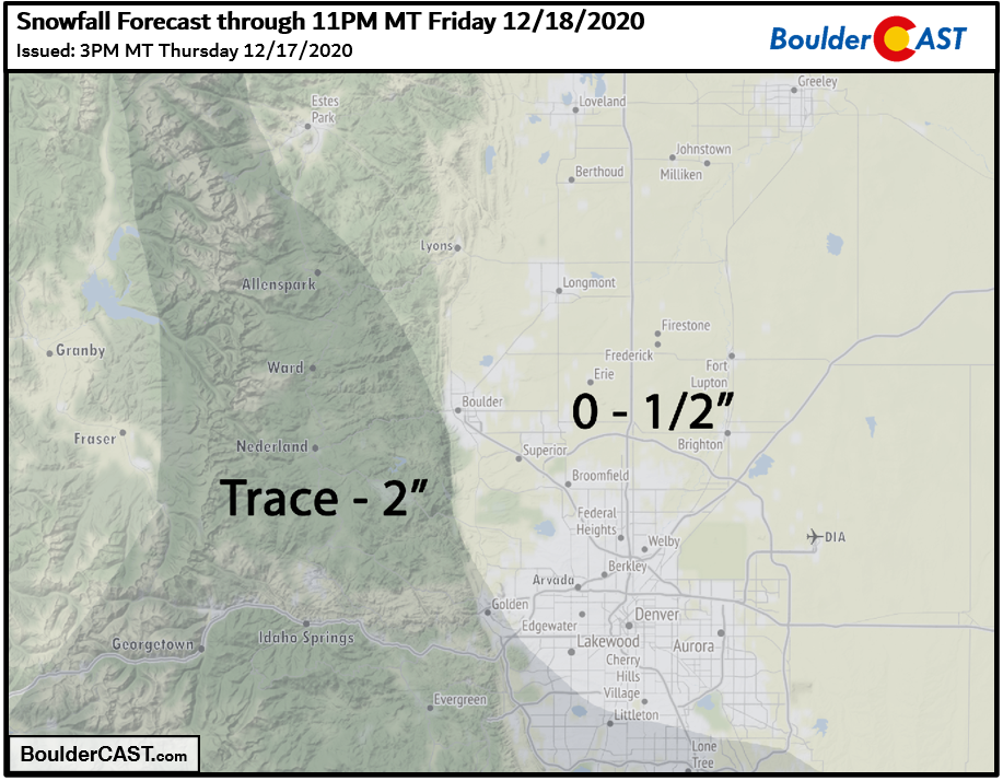
- Snowfall amounts up to 2″, but most areas less than 1/2″
- Ski resorts of north and western Colorado poised to get 2-5″
Help support our team of Front Range weather bloggers by joining BoulderCAST Premium. We talk Boulder and Denver weather every single day. Sign up now to get access to our daily forecast discussions each morning, complete six-day skiing and hiking forecasts powered by machine learning, first-class access to all our Colorado-centric high-resolution weather graphics, bonus storm updates and much more! Or not, we just appreciate your readership!

Will anyone see more than 1″?
We won’t bore you with the finer details of this particular snow event. It’s not all that different from the one we covered in more detail this past Monday. Just be aware that yet another weak storm system is forecast to move through our area from the northwest (see below). The track is not great again for us; it’s too far south.
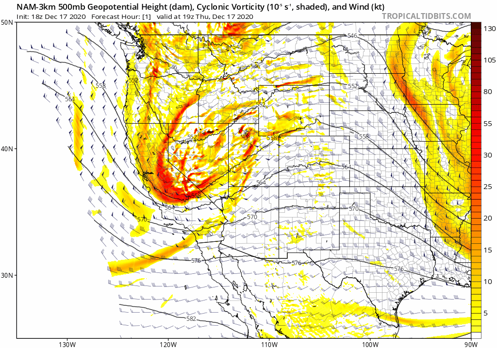
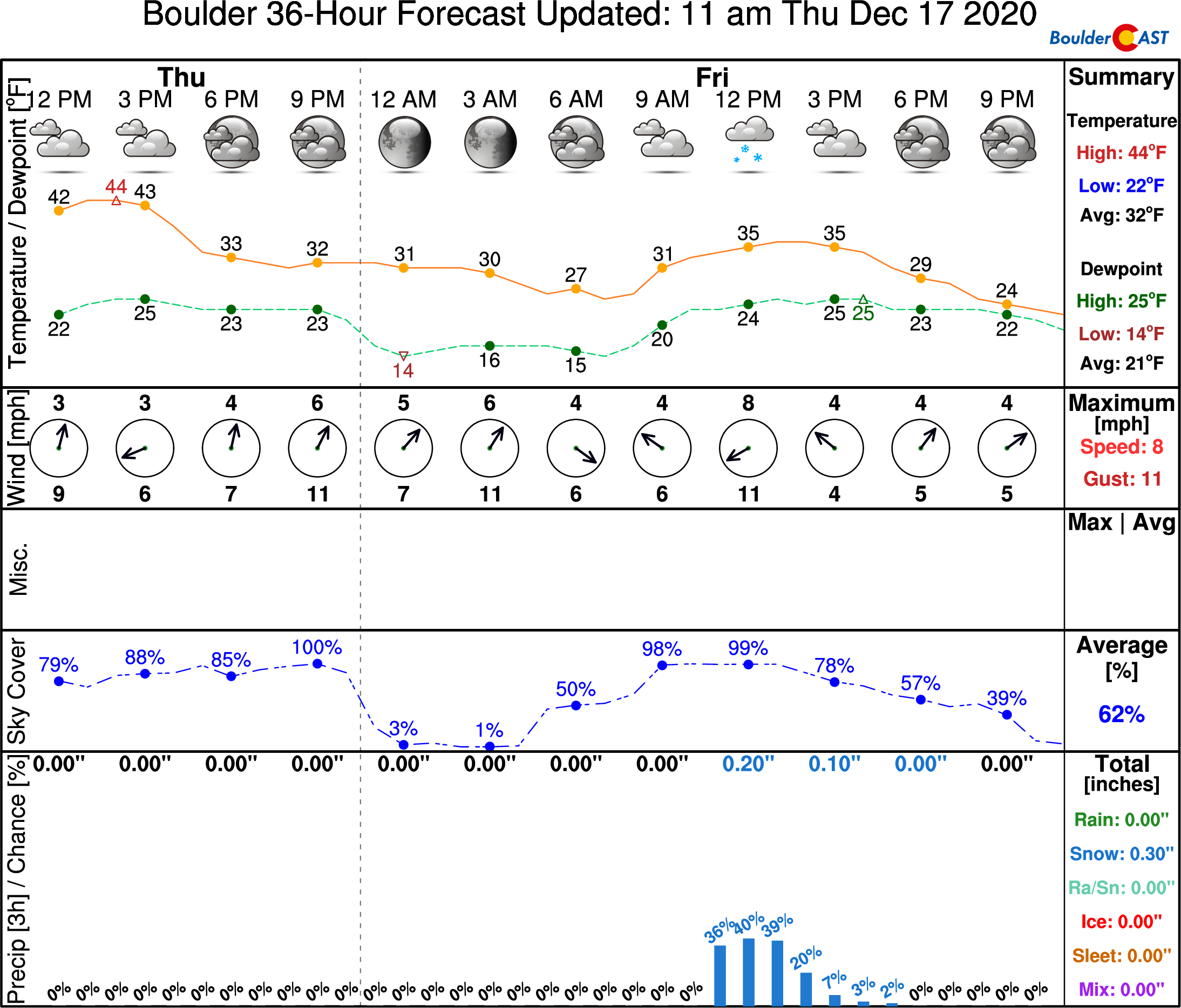
Probably the biggest issue with this system is the speed which has unfortunately been a theme of late. The storm will be racing across Colorado with the jet stream during the day Friday. In fact, this storm is moving even quicker than any of those of late with a window for snowfall of just four to six hours or so. However, those few hours could be somewhat fruitful for areas in the Palmer Divide and Jefferson County Foothills. The reason for this? A quick shift in the winds following a cold frontal passage Friday morning! North-northeasterly winds will be present at the surface and all the way up into the middle atmosphere during this time. This direction favors areas south and southwest of Denver.
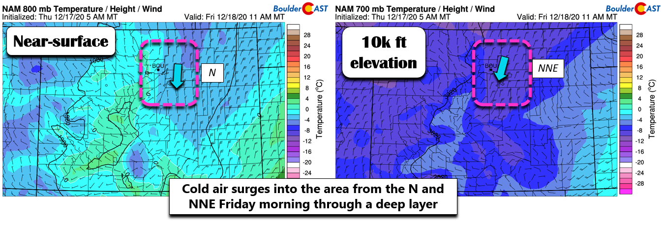
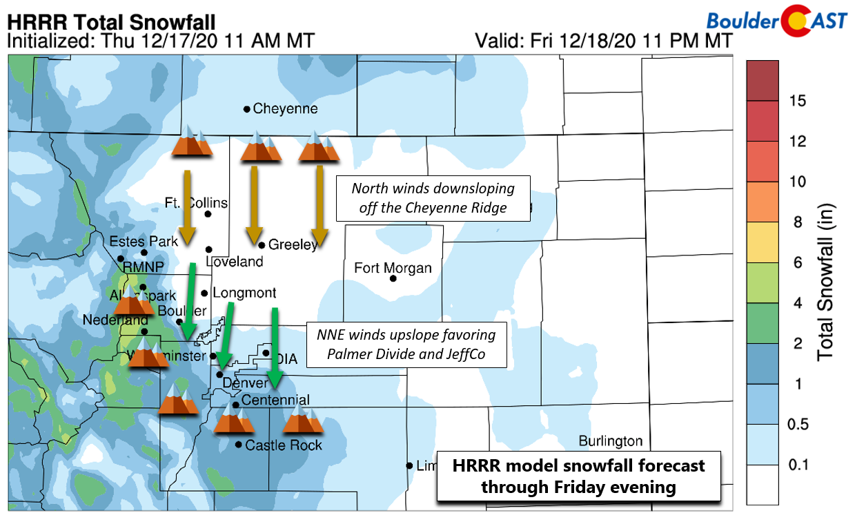
The upslope will also be well-timed with some scant upper-level energy moving through the region, though as mentioned, most of it is across the Mountains and southern Colorado. The HRRR model-derived snowfall forecast is shown below. Overall we’re not looking at much snow at all for the Boulder and Denver areas. Again, we see the upslope-favored areas for north-northeast flow getting the most. We also note a clear signature of downslope coming into the northern Front Range down off the Cheyenne Ridge. Any location north and northeast of Boulder could see no snow at all due to this drying and sinking effect.
Snow will begin in the Mountains overnight before spreading east and south across the Plains during the late morning hours. Things will be light overall and wrap-up relatively quickly, likely by mid-afternoon or so. For temperatures, middle 30’s tops.
Our snowfall forecast map for the event is shown below. This covers snow falling through Friday evening. Travel impacts will be next to non-existent with this one.
More snow will fall in the Mountains with this system, but still only about 1-5″ for the ski resorts statewide.

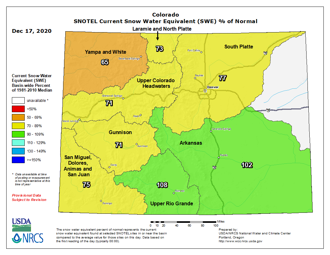
Those 1 to 5″ are not going to put much of a dent in Colorado’s snowpack deficit, which as of late has grown considerably in northern and northwestern portions of the state.
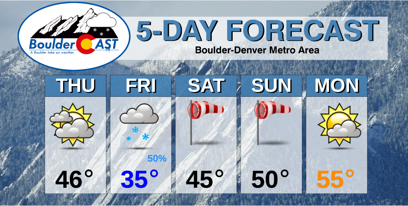
Through the weekend ahead, gusty winds will be the main concern and there may even be a downslope wind event on Sunday if we play our cards right. We’re still waiting on the model consensus for that. Our next chance of precipitation should hold off until sometime early next week. Here’s a look at the five day forecast.
Have a good end to the week!
.
Get BoulderCAST weather updates delivered to your inbox!
We respect your privacy. You can unsubscribe at any time.
Help support our team of Front Range weather bloggers by joining BoulderCASTPremium. We talk Boulder and Denver weather every single day. Sign up now to get access to our daily forecast discussions each morning, complete six-day skiing and hiking forecasts powered by machine learning, first-class access to all our Colorado-centric high-resolution weather graphics, bonus storm updates and much more! Or not, we just appreciate your readership!
.
Spread the word, share this BoulderCAST post:
.


You must be logged in to post a comment.