Winter has resettled into the area following a weak storm system yesterday when light snow accumulations were reported across the entire Denver Metro area. Yet another period of widespread light snow will move into the Front Range Saturday evening. We’re predicting slightly larger totals from this next storm. Read on to find out how much snow to expect and also more about the next chance of winter weather which we are already tracking for late Monday.
At a Glance:
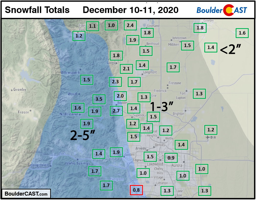
- Yesterday’s light snow event produced generally 1-3″ regionwide, right in-line with expectations
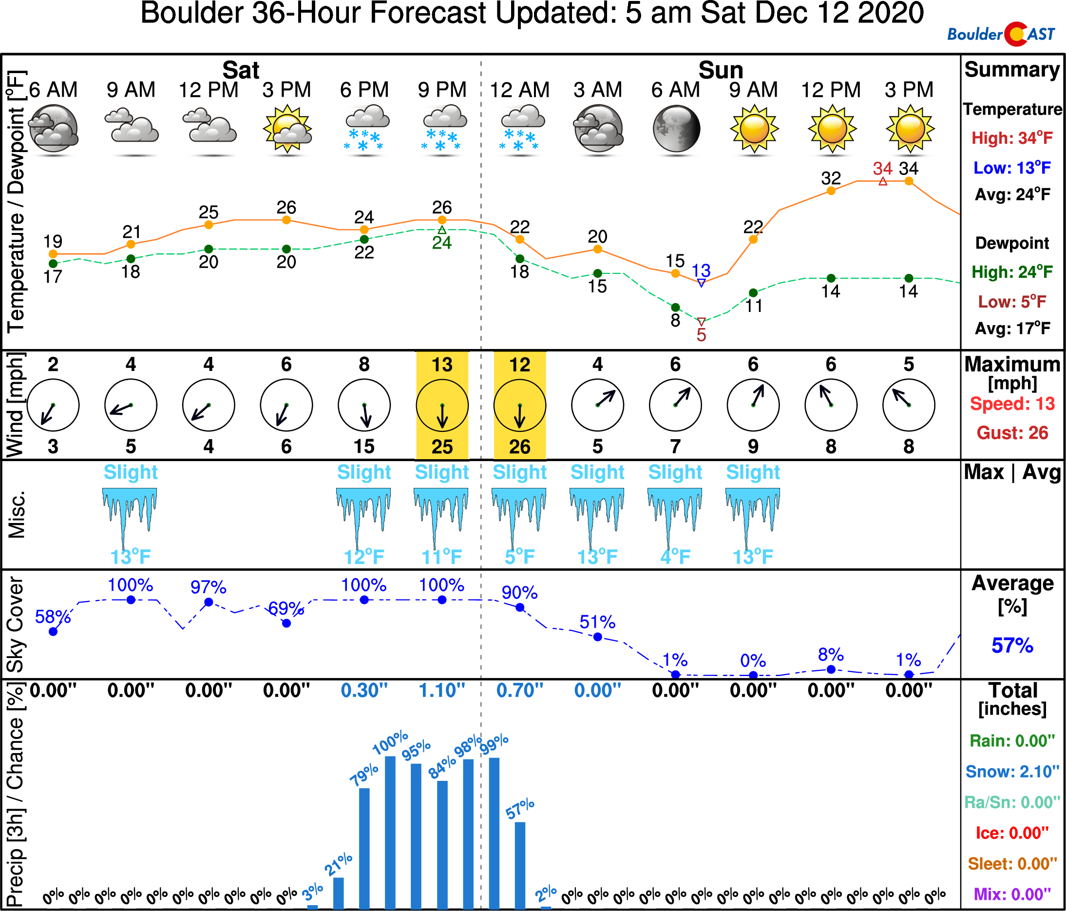
- A slightly stronger/colder storm system will impact the Front Range Saturday evening into the night-time hours
- While ingredients are more favorable for snowfall this time around, the impact will be limited by the brevity
- High confidence in the snow forecast with excellent model agreement, 2-5″ of snow expected for most areas
- More snow queuing up for late Monday
Help support our team of Front Range weather bloggers by joining BoulderCAST Premium. We talk Boulder and Denver weather every single day. Sign up now to get access to our daily forecast discussions each morning, complete six-day skiing and hiking forecasts powered by machine learning, first-class access to all our Colorado-centric high-resolution weather graphics, bonus storm updates and much more! Or not, we just appreciate your readership!

Recap: Round #1 was weak
The first wave of snow began Thursday evening before midnight and continued into Friday afternoon across the Denver Metro area. As the storm played out, it was clear that snowfall rates were even weaker than expected, likely the result of models over-estimating the moisture content of the atmosphere. Despite more or less continuous snowfall for 18 hours in some areas, snow totals were on the light side…but of course still within our forecast’s expectations.
Shown below is our snowfall forecast map issued Thursday morning with actual storm totals overlaid in boxes. Green boxes indicate that our forecast verified to within one inch of the observed snowfall. Red did not. The official snow totals were 2.7″ in Boulder and 1.2″ in Denver (at DIA). Generally, most areas landed in the 1 to 3″ range from this past event.
Forecast: Round #2 arrives Saturday evening
In our initial snowfall forecast discussion issued on Wednesday, we suspected the second wave of snow this weekend would be more impactful than the first and that certainly appears to be true.
The surprisingly active weather pattern across the Rockies will continue today with yet another storm system dropping southward out of western Canada and across Colorado. The low pressure in question is currently located over far western Wyoming. Most of the energy with this storm system will push across western, central and southern Colorado.
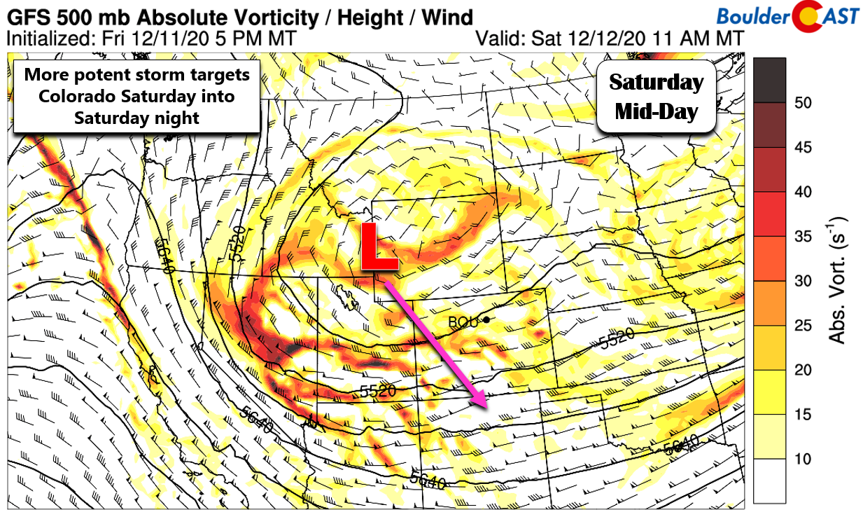
However, the Front Range will be just on the edge with plenty of lift and moisture to support widespread snowfall development Saturday afternoon across the Mountains and by early evening across the Foothills and Plains. Almost every aspect of this secondary winter storm will be more favorable for accumulating snowfall across the Front Range compared to what we saw with the past event Thursday night and Friday. It’s a more potent overall storm system. It has stronger and deeper upslope. There will be more substantial energy to work with. Moisture is higher. There is slightly colder air aloft which will favor higher snowfall ratios. About the only facet to complain about this time around is the brevity. The favorable ingredients will arrive and exit the area within only about 12 hours leading to a relatively short window of snowfall for us. Even still, with embedded pockets of more moderate snowfall, this storm will offer the chance for several inches of snow for everyone!
The animation below shows the simulated precipitation forecast from the high-resolution HRRR model in northeast Colorado. Snow should begin to fall by late afternoon or early evening in Boulder and continue through entire evening, wrapping up just after midnight for the very southern Metro area.
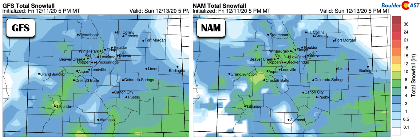
How much snow can we expect? Let’s run through a few model projections quickly just to see how consistent the forecast is this time around. It really surprises even us to see this great of model agreement. Here’s a look at the GFS and NAM model-derived snowfall forecasts for this storm. The GFS shows about 1-3″ for the area, while the NAM is leaning towards 2-5″.
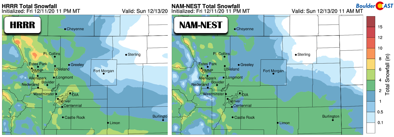
Higher-resolution models indicate very similar amounts, as shown below. Note that our high-resolution graphics (below) have slightly different coloring thresholds than the global/regional models (above). The HRRR model has about 2-5″ for the area, while the NAM-NEST projects 2-4″.
Thus, we’re very confident in predicting that most areas should come out with a solid 2-4″ from this snow event Saturday evening. This is a fairy run-of-the-mill La Niña snowstorm for the Front Range…
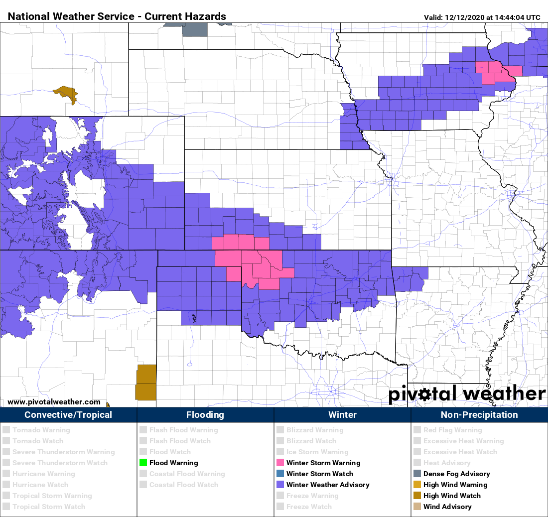
The National Weather Service has posted Winter Weather Advisories for the western and southern Denver Metro area as well as the Foothills and Palmer Divide. Much of the Mountains and southeastern Colorado are also under similar highlights. Again… while our area is towards the edge of the best lift with this storm, we are definitely still in the mix!
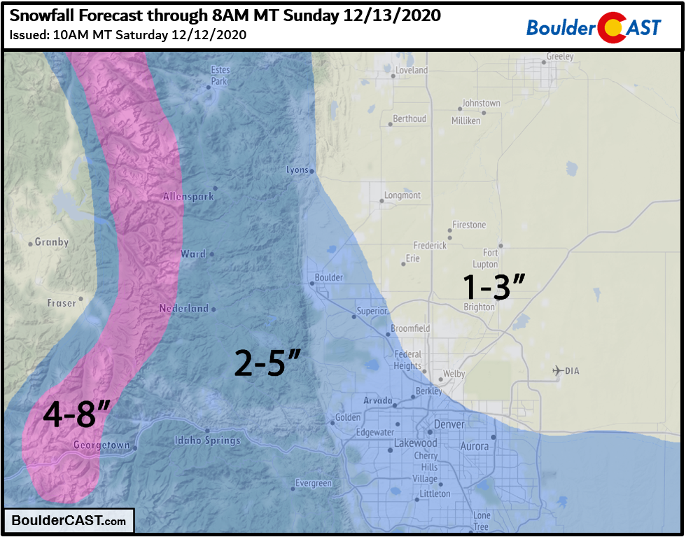
Shown below is our snowfall forecast map for the event. This covers snow falling Saturday and Saturday night.
Do be careful if traveling Saturday evening as roadways will certainly become slick in spots considering the cold temperatures (20’s and teens) and the predominantly after sunset timing of the snowfall. We tried to keep this forecast update today brief. However, for more details on the specific factors at-play with this storm, read this morning’s Premium BoulderCAST Daily forecast discussion.
We hope you’re not too tired of the wintry weather just yet. Saturday evening’s snow event isn’t the only one on our radar right now. Yet another period of light snow is taking shape for late in the day Monday with the potential for another round of similar snow amounts. We’ll catch you up on that forecast at a later time. Have a joyous rest of the weekend and stay warm!

Get BoulderCAST weather updates delivered to your inbox!
We respect your privacy. You can unsubscribe at any time.
Help support our team of Front Range weather bloggers by joining BoulderCASTPremium. We talk Boulder and Denver weather every single day. Sign up now to get access to our daily forecast discussions each morning, complete six-day skiing and hiking forecasts powered by machine learning, first-class access to all our Colorado-centric high-resolution weather graphics, bonus storm updates and much more! Or not, we just appreciate your readership!
.
Spread the word, share this BoulderCAST post:
.


You must be logged in to post a comment.