Today was the 17th consecutive day of above average temperatures and dry conditions in Boulder and Denver. It’s about time for a change…don’t you think? Several atmospheric ingredients will be coming together over the next several days to bring cloud cover, much cooler temperatures, and the potential for significant rainfall to the state of Colorado. The atmospheric moisture content statewide will be close to all-time record levels for the month of June. With so much moisture involved, some areas could see heavy rainfall capable of producing flash flooding. Read on for details.
Category: Forecast (Page 123 of 169)
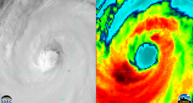
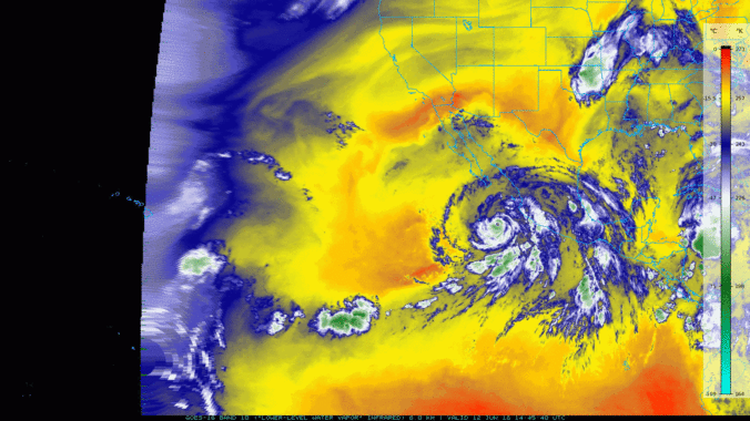
A favorable atmospheric set-up will help to funnel the remnants of Hurricane Bud, currently churning off the coast of western Mexico, into Colorado over the upcoming weekend. We discuss the impacts this will have for the Front Range and the rest of the state.
A brief reprieve from the heat will begin our week thanks to a cold frontal passage. Unfortunately, it won’t last long with temperatures quickly returning back into the 90’s. We also discuss a potential wet upcoming weekend dependent upon how the remnants of Hurricane Bud evolve over the coming days. Read on for more details.
Are you tired of the heat yet? We discuss the weather pattern responsible for the recent heat wave and explain why it’s going to be difficult to unseat this hot airmass heading forward. Continue reading
The weather pattern for the week ahead will exhibit shades of the middle of summer with a ridge of high pressure parked across the south-central United States. As a result, temperatures in the Metro area will soar into the 90’s with only limited chances for rainfall through the week. This forecast doesn’t bode well for the meager snowpack remaining across the High Country.
After a long Memorial day weekend, the shortened work-week starts off cooler with thunderstorms, but drier and warmer weather lies ahead. Read on for more details.

With the arrival of Memorial Day Weekend, summer is unofficially set to begin! The weather will follow suit across the Denver Metro area with temperatures heating up into the 90’s. There will also be a few chances for rain. Read our holiday weekend forecast for all the details.
Continue reading

*Contest closes May 30, 2018 at 11:59 PM*
All of our previous contests have involved predicting some aspect of snowfall in Boulder. This changes today! Your goal this time around will be forecasting how intense the summer heat will be during the upcoming months of June, July and August. To help you along with your prediction, we provide a brief overview of the climatology and cover what the models are predicting for this summer. Prizes include a $50 Amazon gift card and Premium subscriptions. Get your forecast in now!

Live View of Boulder

Current Conditions

Live Radar

Latest Smoke Forecast

Recent Premium Posts

BoulderCAST Daily – Fri 07/17/26 | Hot and dry continues through the weekend
🥵 Heat tightens its grip this weekend — Ridge strengthens slightly over the …
This Weekend in Colorado Weather: Several More Scorching Days Ahead Before the Long‑Awaited Monsoon Pattern Arrives
☀️ Persistent heat continues — Low to mid‑90s through Saturday, spiking towards the …
BoulderCAST Daily – Wed 07/15/26 | The Ridge Rules the Rockies as Hot, Dry Pattern Holds Firm
🔥 Heat dome setup continues — A strong, stationary 500 mb ridge keeps …
3-Day Forecast

Trending Content

© 2026 Front Range Weather, LLC