
A brief reprieve from the heat will begin our week thanks to a cold frontal passage. Unfortunately, it won’t last long with temperatures quickly returning back into the 90’s. We also discuss a potential wet upcoming weekend dependent upon how the remnants of Hurricane Bud evolve over the coming days. Read on for more details.
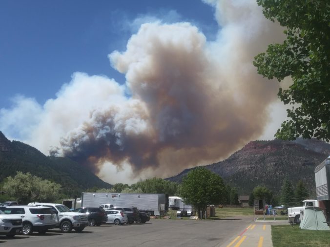
416 Fire burning near Durango
The above image is taken from the 416 Fire that developed June 1, 2018 about 10 miles north of Durango in far southwestern Colorado. The fire was approximately 8,000 acres in size Saturday, and has grown to nearly 17,000 acres as of this morning. It is only 10% contained, with 813 personnel working to control the wildfire. The current fire map is shown below, with much of the burn area north of Durango.

416 Fire near Durango, CO
The smoke from this fire (and many others across the Southwest) may envelop our region through the week, which could lead to air quality issues and beautiful sunsets. It’s already looking fairly smoky as of Monday morning.
Early week “cool down”
The week will start off cooler thanks to a cold front that slid through late last night. This is shown below, with the frontal position draped across our region.

NAM 800 mb temperature across the nation today
A more zoomed in picture is shown below over Colorado. The front is related to a quick-moving trough well to our north in Canada. Much of the cold air will also remain well to our north. Nevertheless, enough northeasterly flow has taken hold to give us a brief reprieve from the pesky heat. High temperatures on Monday and Tuesday will be in the 80’s. Nights will also be noticeably cooler, too, allowing for a break for that air-conditioner!
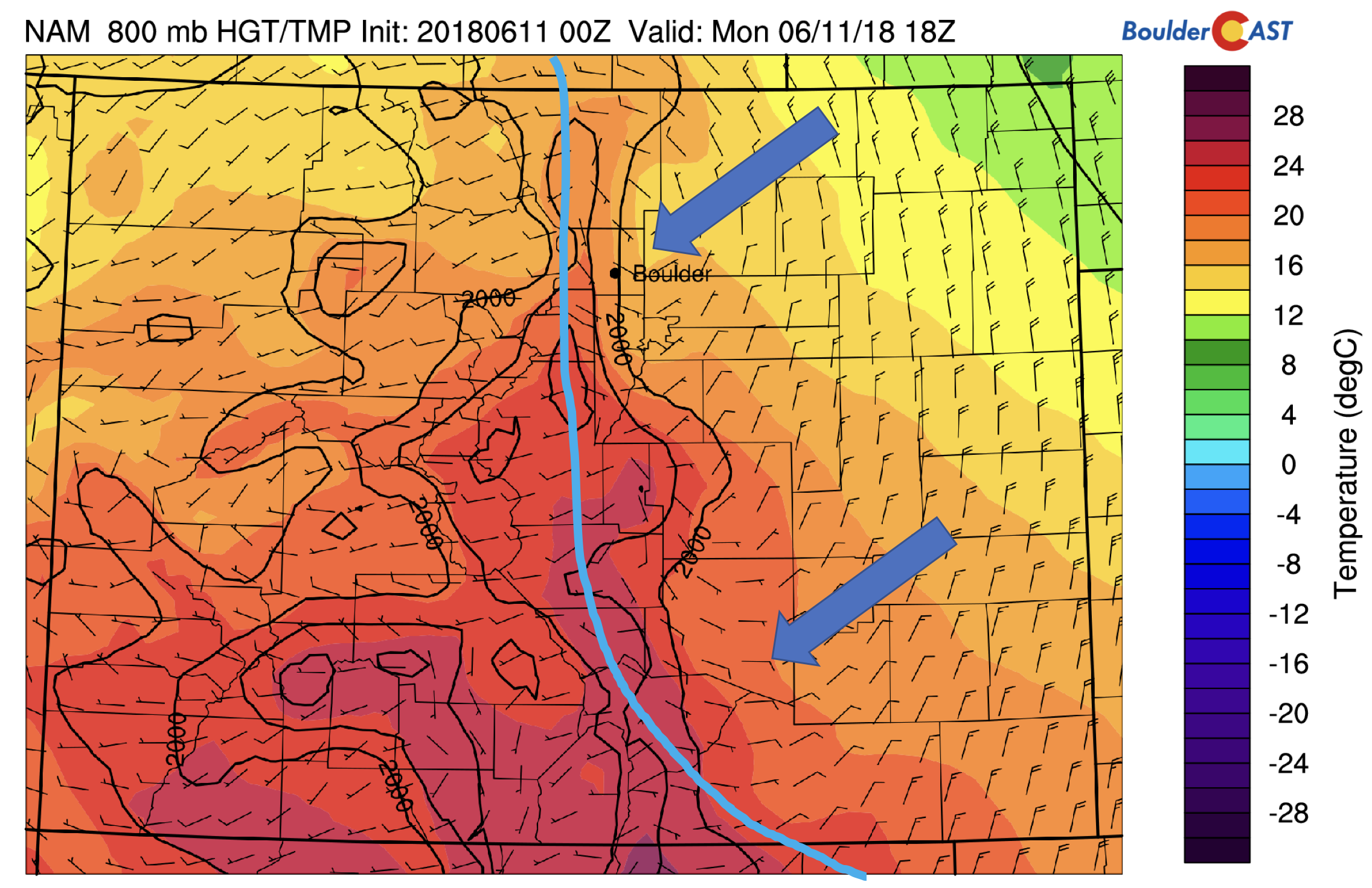
NAM 800 mb temperature over Colorado today
Slight chance of storms through the week
Come Tuesday and Wednesday, the heat will slowly build back into the area. Below shows the mid-level pattern on Tuesday and Wednesday. The high pressure ridge on Tuesday will be positioned just to our southeast near the Texas Panhandle. On Wednesday, the ridge pushes ever so slightly to the east. This transition into midweek will allow a slight chance of isolated afternoon/early evening storms with atmospheric moisture increasing just a tad. Most of us will remain dry, though. Nevertheless, a few ripples of energy around the ridge (shown below) may help to produce a few pop-up thunderstorms. Expect highs returning to the 90’s beginning on Wednesday.

GFS 500 mb absolute vorticity on Tuesday (top) and Wednesday (bottom)
Heat main story to end the week…unsettled for the weekend??
Much of the remainder of the week can be summed up in one figure (see below). It shows the low-level temperature pattern over the nation for Wednesday. The heat rebuilds from midweek through Friday as southwesterly flow returns. We can expect low to middle 90’s for Thursday and Friday. There are some hints a weak trough and cold front may approach as early as Friday morning, which may lower highs by several degrees. However, only the GFS model is showing this right now. The Euro is delayed with this trough and thus keeps northeast Colorado toasty on Friday as well.
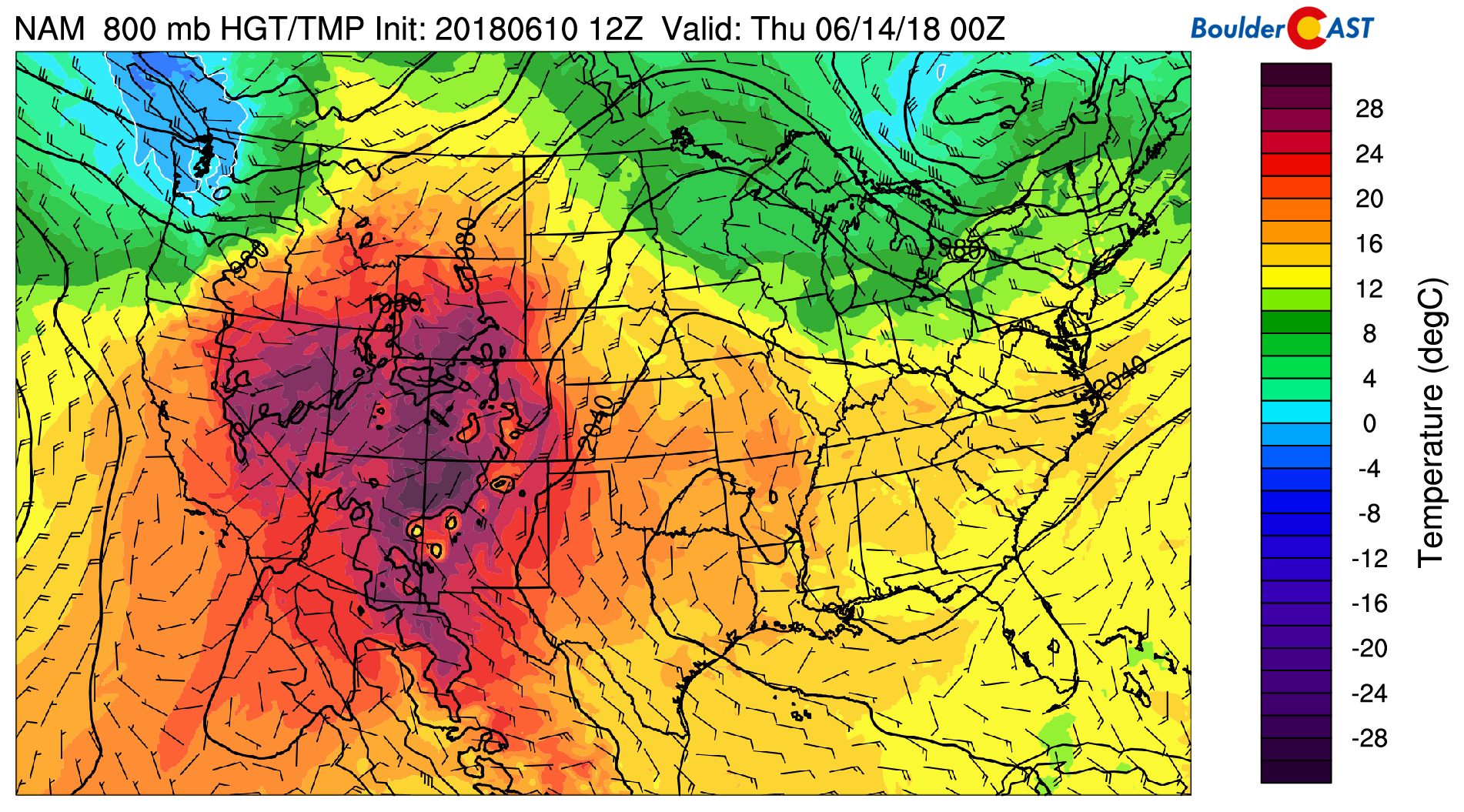
NAM 800 mb temperature Wednesday
The upcoming weekend will be something to watch. Below shows the precipitable water pattern early Saturday from the GFS. Notice the trough digging into Utah. At the same time, Hurricane Bud in the Eastern Pacific is expected to move into Baja California. Thirdly, there is the potential for another tropical wave to move northward in the Gulf of Mexico. The southerly push from the trough, as well as the remnants of Hurricane Bud, may increase the moisture content in the atmosphere over our state for the upcoming weekend. That combined with daytime heating should result in an increased threat of shower and thunderstorm activity. We’ll certainly watch this as we get closer.
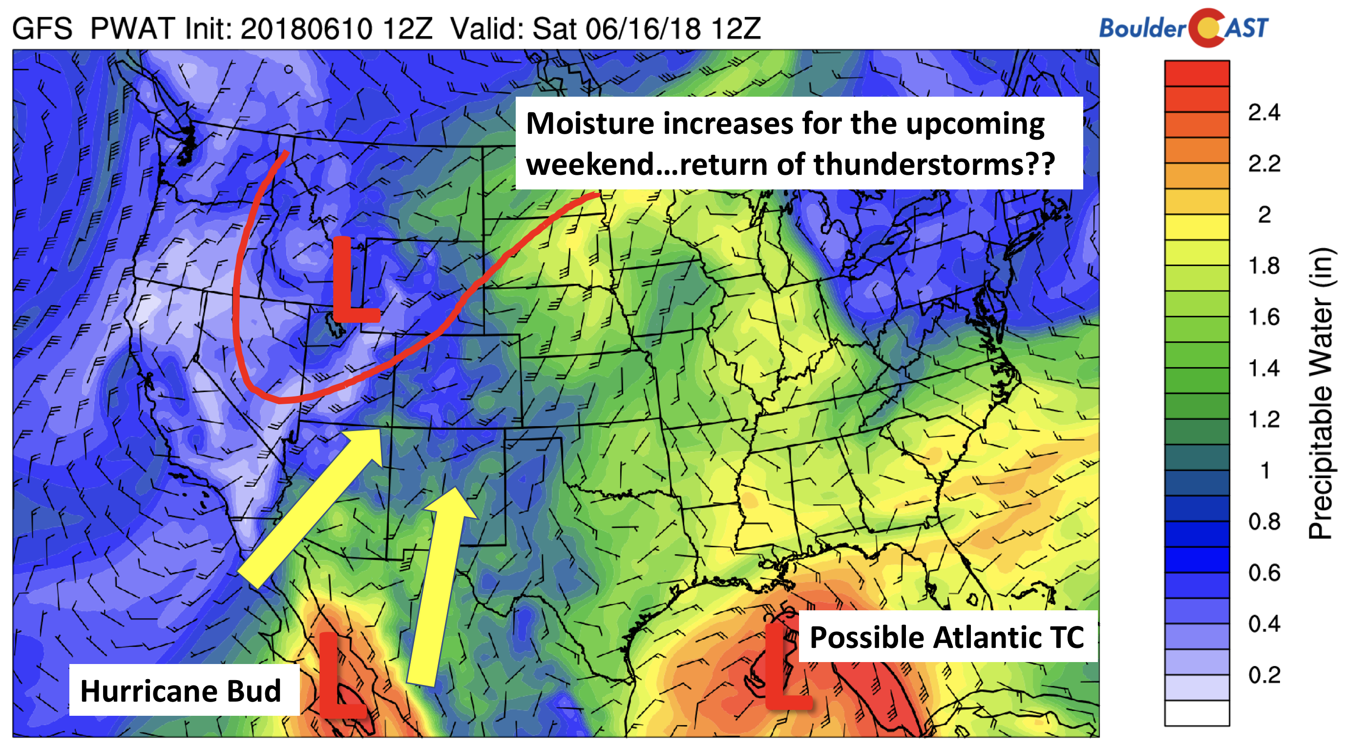
GFS precipitable water for Saturday
Hurricane Bud’s track forecast is shown below from the National Hurricane Center. It’s expected to reach Baja late Friday night. It’s remnants will increase moisture across the Desert Southwest over the weekend, possibly pushing as far north as Colorado.

Hurricane Bud forecast from the National Hurricane Center
Satellite animation of Hurricane Bud as of Sunday night
Finally, below shows the accumulated precipitation from the GFS through Friday. Outside of a few isolated storms this week, much of our weather will be dry. That all may change come the weekend and early next week…so stay tuned.

GFS total precipitation accumulation through Friday
Stay cool and have a great week!
Forecast Specifics:
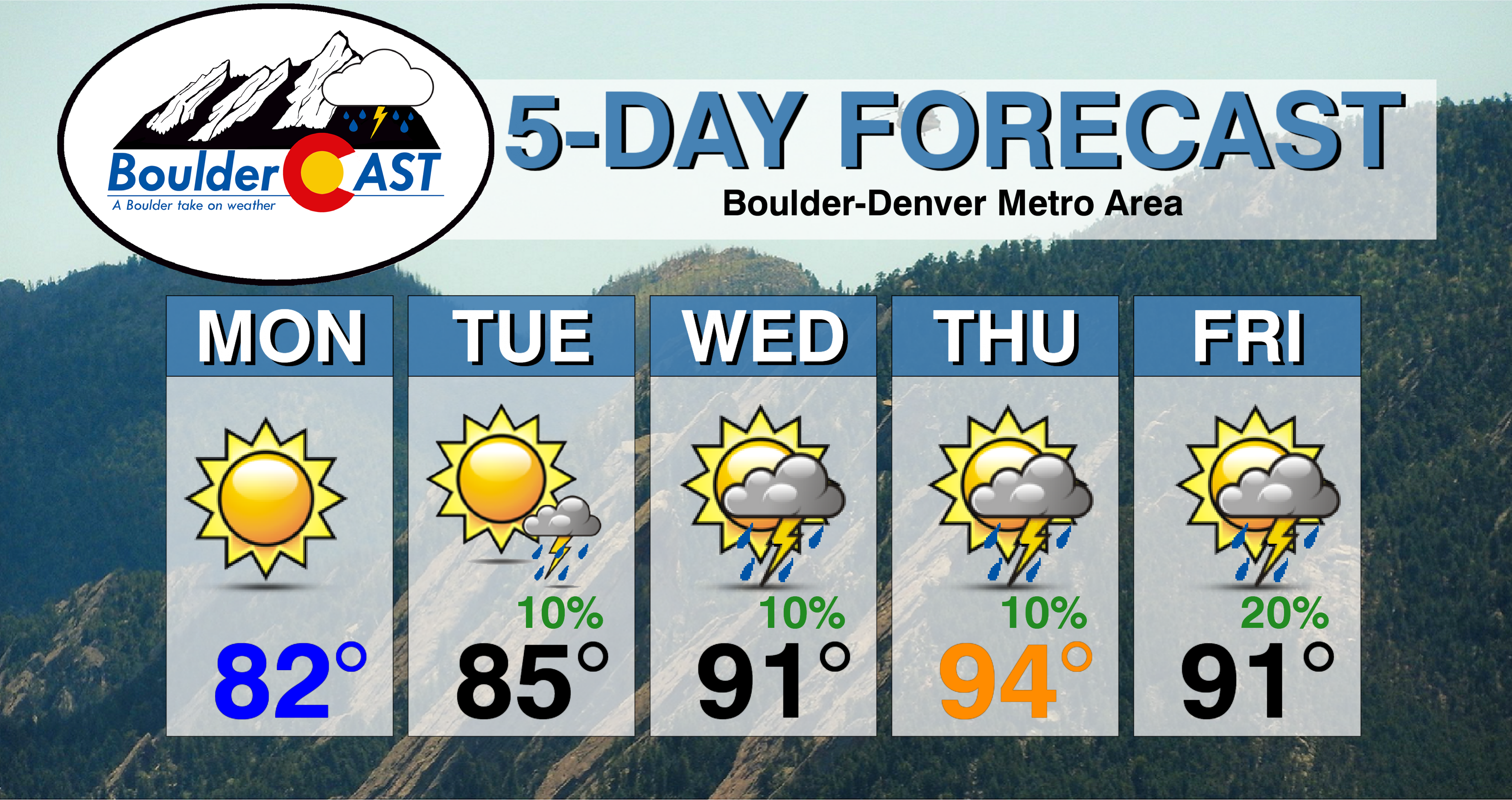
Monday: Sunny with highs cooler in the low to middle 80’s across Plains and in the low 70’s in the Foothills.
Tuesday: Mostly sunny skies to become partly cloudy with an isolated storm or two possible in the late afternoon to early evening, mainly south and east of Denver. Highs in the mid to upper 80’s on the Plains with middle 70’s in the Foothills.
Wednesday: Sunny with increasing afternoon clouds with isolated afternoon and evening thunderstorms, mainly south and east of Denver. Highs in the lower 90’s on the Plains and upper 70’s in the Foothills.
Thursday: Partly cloudy and hot with isolated afternoon thundershowers. Expect highs in the low to middle 90’s for the Plains with lower 80’s in the Foothills.
Friday: Partly cloudy to mostly cloudy with isolated afternoon and evening thunderstorms possible. Highs are expected to be in the low 90’s on the Plains and upper 70’s in the Foothills, though some models are indicating a cooler airmass with highs up to 10 degrees cooler.
High Country: It will be a warm week as well over the mountains. A slight chance of storms will exist Tuesday through Thursday across the High Country, only about 10%. Most will be spotty in nature, but do be on the lookout for quick-changing skies to avoid lightning danger. Increased moisture to end the week will bump the storm threat Friday and through the upcoming weekend. Be sure to check out SummitCAST for twice daily updated forecasts for over 100 Colorado hiking destinations!
DISCLAIMER: This weekly outlook forecast was created Monday morning and covers the entire upcoming week. Accuracy will decrease as the week progresses as this post is NOT updated. To receive daily updated forecasts, subscribe to BoulderCAST Premium.

.
Share our forecast!


You must be logged in to post a comment.