Are you tired of the heat yet? We discuss the weather pattern responsible for the recent heat wave and explain why it’s going to be difficult to unseat this hot airmass heading forward.
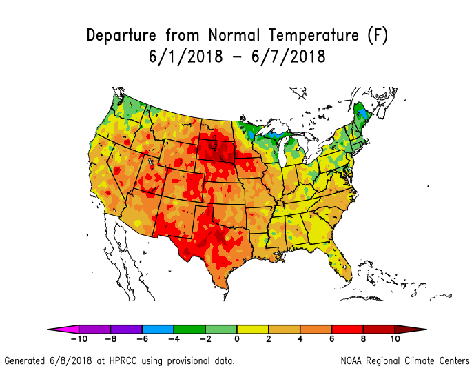
The first week of June has been a hot one for much of the country. This is especially true for the central United States where temperatures have averaged some 5 to 10 degrees above normal.
The cause of the heat has been a stagnant weather pattern consisting of a large ridge of high pressure centered across northern Mexico and Texas. We stressed the importance and impacts of this feature in our weekly outlook.
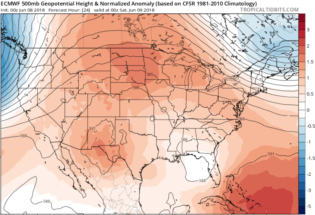
European model 500 mb height anomaly forecast for Friday evening.
The lack of much wind flow and sinking air from the ridge led to a build-up of pollutants in the atmosphere this week, and thus Ozone Action Days for the Front Range on Wednesday and Thursday. Ozone levels exceeded the EPA standard of 70 ppb (parts per billion) for nearly four consecutive hours Wednesday afternoon in Boulder. Readings were even higher in Denver.
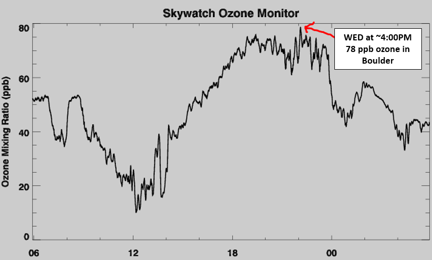
June 6, 2018 ozone levels for Boulder, Colorado.
The Weather Channel has been attempting to dramatize this particular atmospheric set-up….calling it “The Ring of Fire” pattern. Sounds intense, right? In reality, there’s nothing all that special to it. The overall sluggishness of the pattern and lack of moisture to produce many clouds has led to a continual warming of the air mass each successive day. The below skew-T plot of the left is from Thursday evening’s balloon launch in Denver. It depicts the current vertical extent of the heat in the atmosphere. We have outlined the temperature profile in red. Notice how the thick red temperature line is very straight and mostly parallel to the thin green lines. This indicates a well-mixed atmosphere all the way to the 430 mb level (to where the temperatures line starts to wiggle). 430 mb is around 25,000 feet above sea-level! How does the atmosphere become well-mixed up to that height? Repeated and strong surface-based heating which leads to deep convection. It works like this…the sun heats the ground, the ground heats the air just above, then that warm air gets mixed upward via convection…every single day, all day. The net effect of this, where we are right now, is a deep layer of atmosphere with temperatures well above normal.
For reference, we also included the skew-T plot from June 7, 2017 on the right. The weather pattern was clearly more active one year ago, but you can get an idea of how substantial the depth of the heating is this year compared to last. 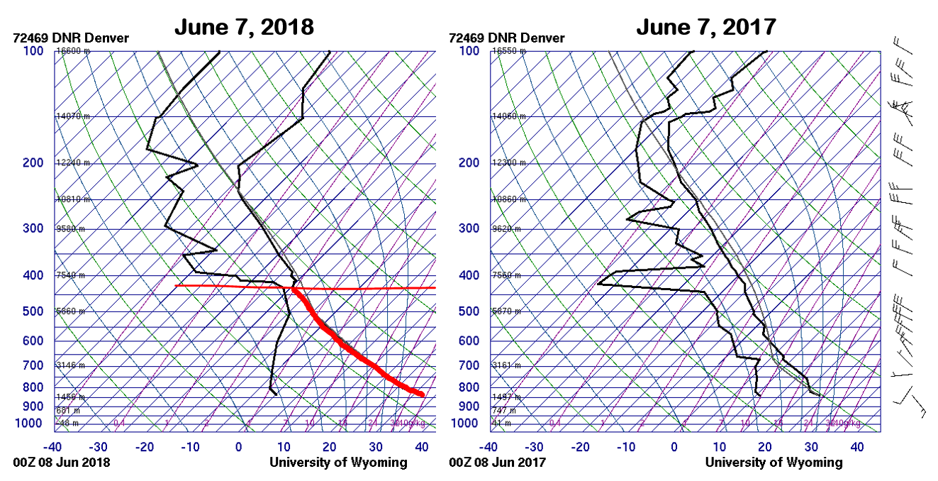
This deep and warm airmass will not be easy to dispel from the region. You may have noticed that temperatures on Wednesday were slightly cooler than the rest of the week….in the middle 80’s, instead of the 90’s per the usual. A weak back-door cold front actually moved into the Front Range early on Wednesday morning. The front’s impact on our temperatures was minimal…not even dropping us close to or below normal for this time of year. By Thursday, we we’re already back in the 90’s again.
It’s going to take a much larger-scale system to break down the heat, not just a wimpy back-door cold front. We’re not seeing signs in the weather models of this happening just yet (for Colorado, at least). A potent storm system will be coming ashore into the Pacific Northwest this weekend..one that is atypically strong for this time of year. It will be packing winds, rain, and much colder temperatures for the Pacific Northwest and Northern Rockies.
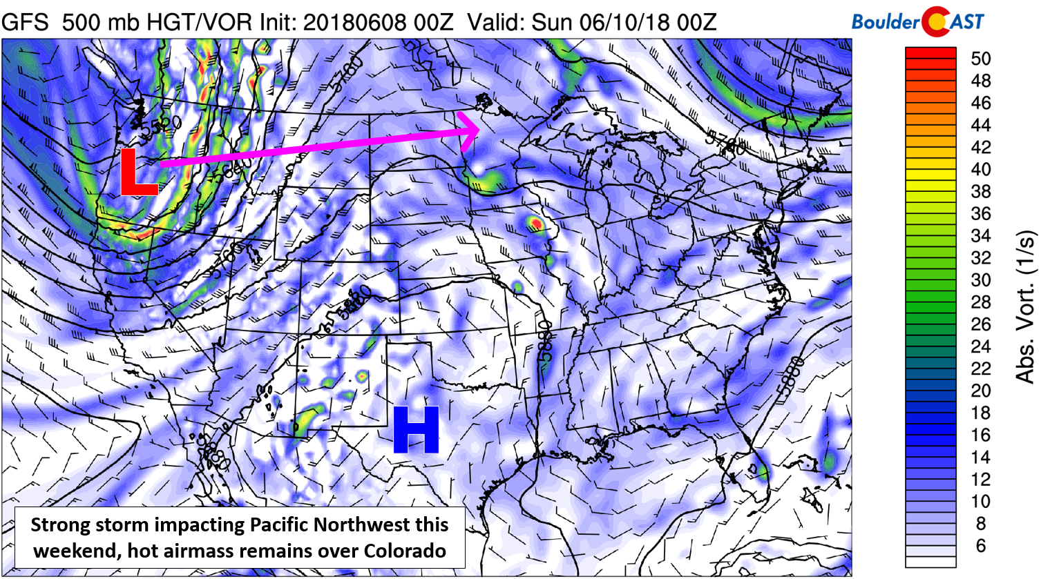
GFS 500 mb vorticity map for Saturday evening. A strong system will be coming ashore into the PNW, with the warm ridge holding across Colorado.
In fact, temperatures will be cold enough for some snow to fall across the higher elevations of Washington, Oregon, Montana, and Idaho over the weekend. Snow levels could drop all the way down to around 4000 or 4500 feet! Can you imagine snow levels dropping that low in our region this time of year?! Keep in mind, it did snow 1.0″ in Boulder on June 12, 1947…so it’s not impossible I’ll remind you.
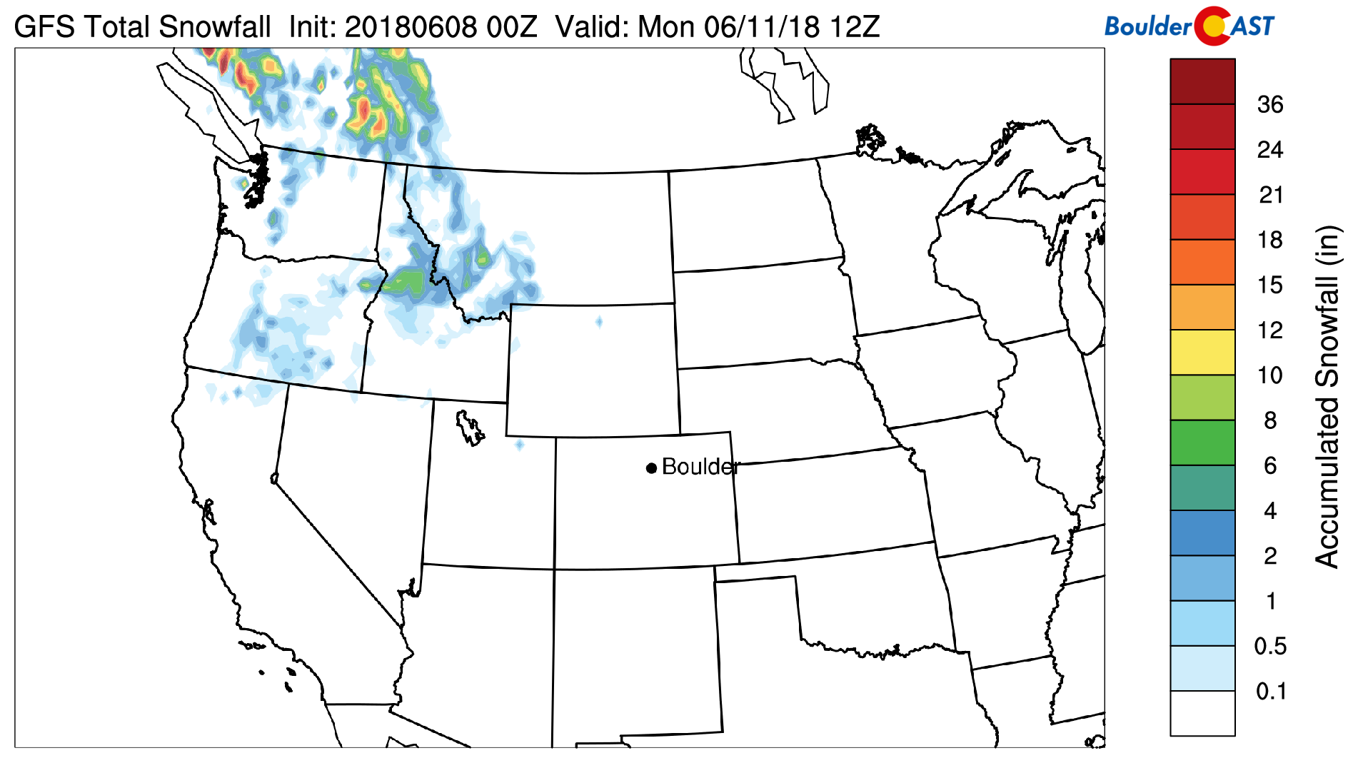
GFS total snowfall forecast through Monday. A potent storm system with very cold air for June will drop snow levels enough to produce light snow accumulations across the higher elevations of the Pacific Northwest.
Temperatures through the weekend will remain the the 90’s across the Metro area with more sunshine than clouds overall. We’ll be pushing the upper 90’s on Sunday. Some lower elevation spots from Longmont to Greeley to Sterling could see triple digits.
Unfortunately for those tired of the heat, that strong trough does not appear to be heading for Colorado. Similar to what happened on Wednesday, the approaching storm system will not have enough power to beat down the ridge across Texas and northern Mexico. The core of the energy and colder air will skirt along the Canadian border through the middle of next week. In northeast Colorado, we can expect another back-door cold front to arrive early Monday morning.
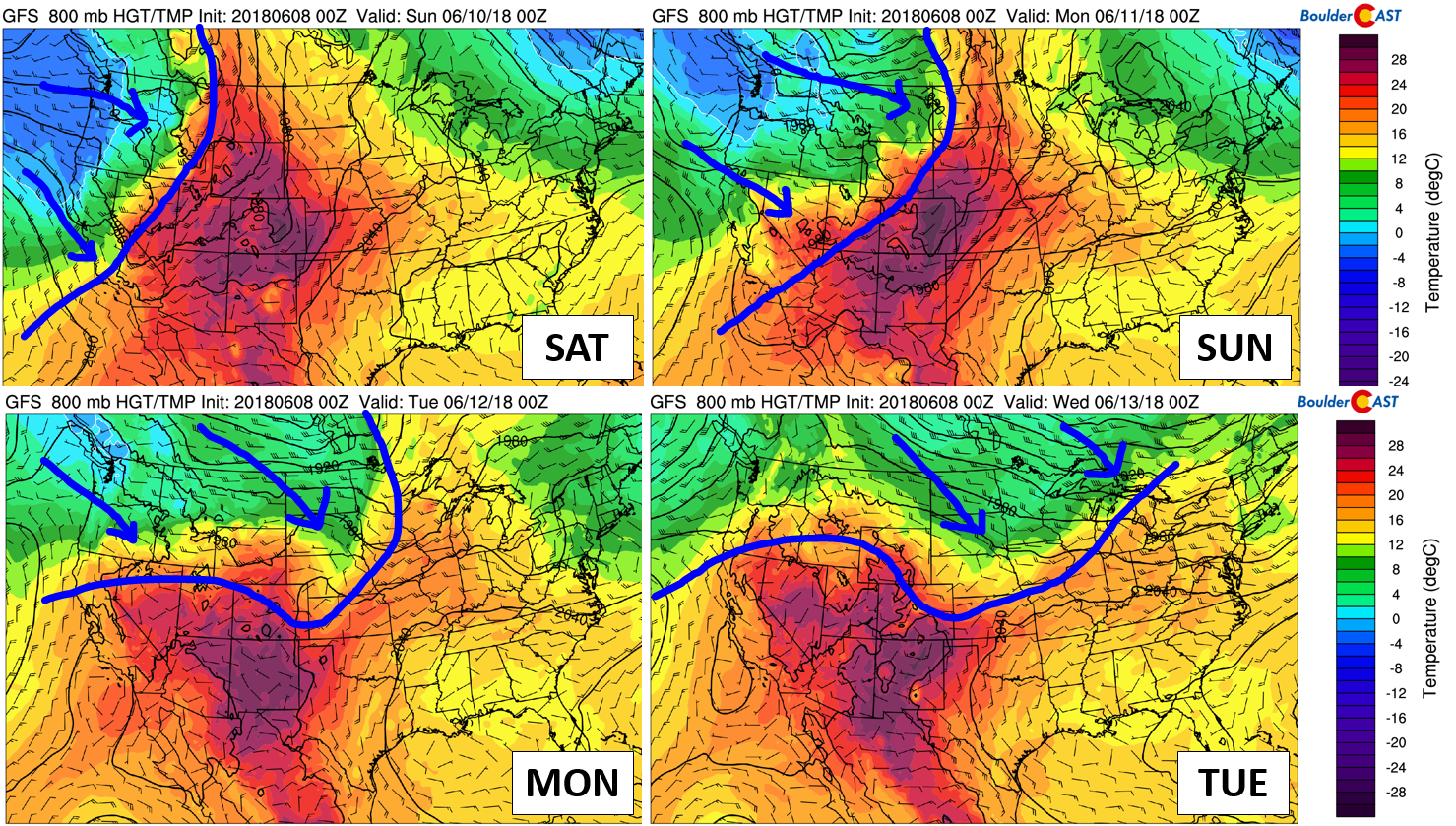
GFS 800 mb temperature forecast for Saturday through Tuesday showing the progression of the cold air.
While we will definitely see less intense heat next week, it will be far from cool. Temperatures are expected to drop back into the low to middle 80’s Monday through Wednesday…still above normal for this time of year. Longer-range models have that same ridge of high pressure rebuilding late next week with similarly hot conditions returning to eastern Colorado.
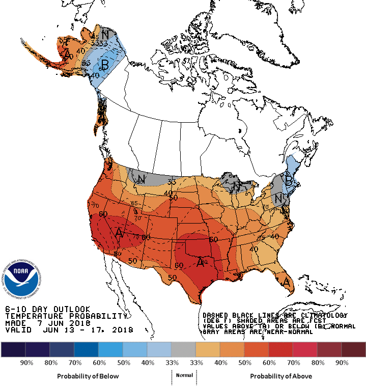
Temperature outlook for June 13-17, 2018 from the CPC.
Another unfortunate consequence of the persistent “Ring of Fire” pattern high pressure pattern has been limited precipitation across the Desert Southwest and southern Rockies. Precipitation totals across the Denver Metro area are meager thus far in June…just a trace in Denver and nada in Boulder. This is quite the change from last month!
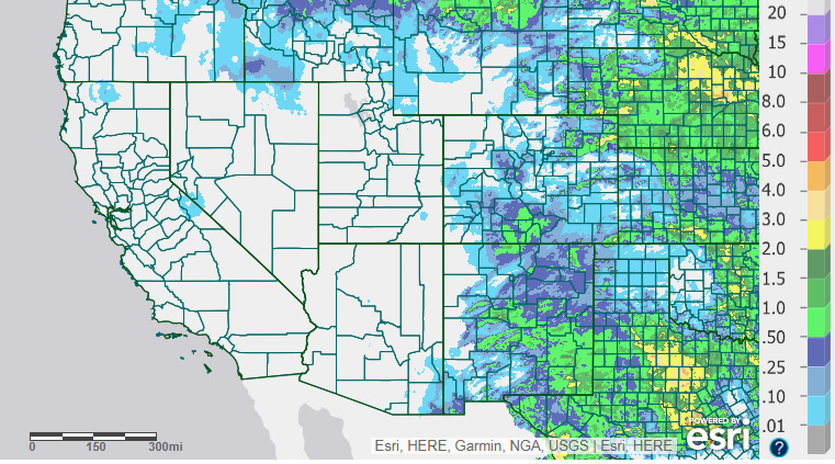
Radar estimated precipitation totals for June 1-7, 2018.
These very dry areas are also those most drought-stricken….
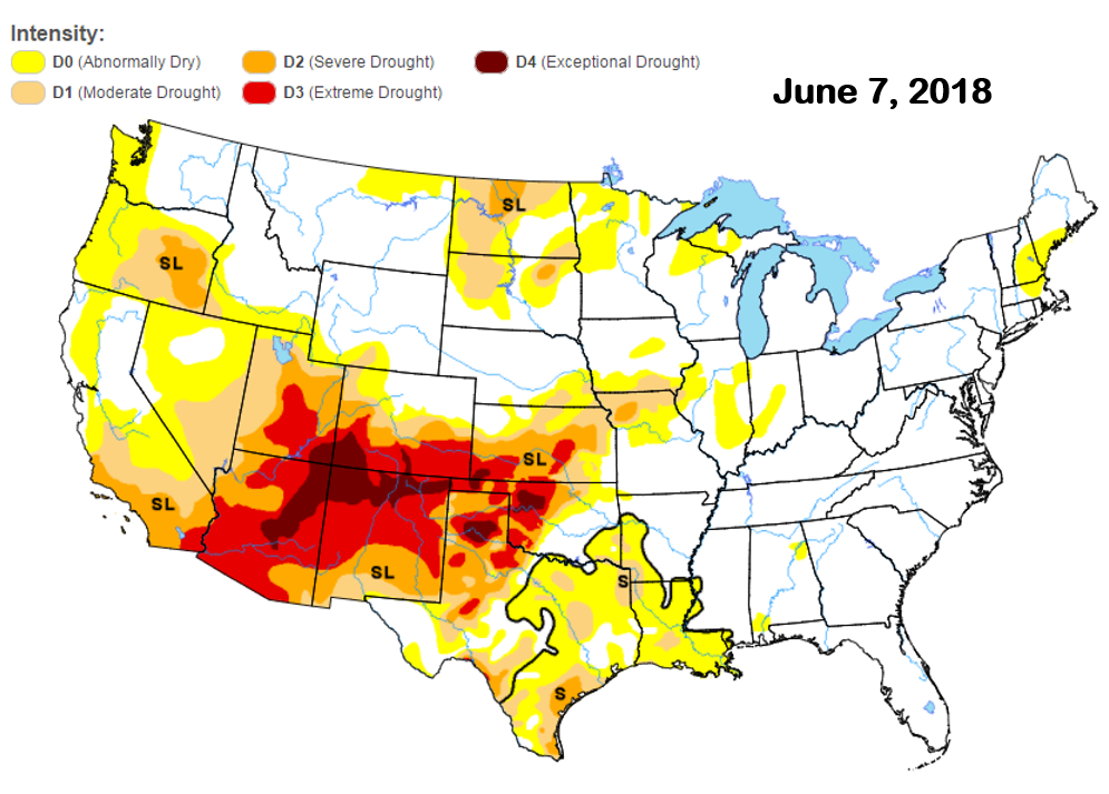
Drought intensity map as of June 7, 2018 from the USDM.
Many large and active wildfires are raging in all of these states, with nearly 100,000 acres currently burning in New Mexico alone. The magenta coloring in the map below denotes active Red Flag Warnings. Fire conditions are prime in areas that are experiencing extreme drought and have seen little if any precipitation in the last three to six months.
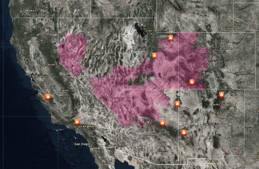
Active fires burning across the Desert Southwest as of June 8, 2018.
With so many actively burning large fires in the United States, but also in Mexico, we’ll probably see periods of light smoke across the Metro area this weekend, into the foreseeable future, and maybe even all summer long…
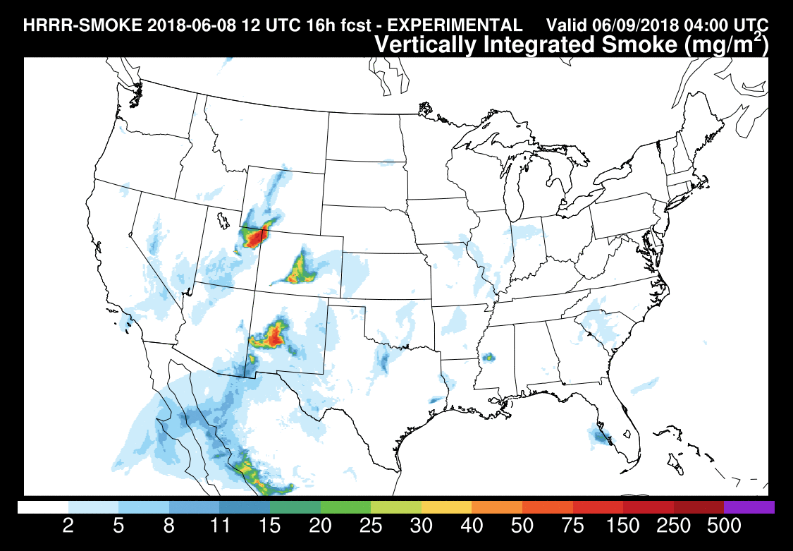
HRRR-SMOLKE model forecast for total smoke Friday night.
We’ll reiterate that the Front Range region is NOT experiencing drought or major wildfire concerns currently. Vegetation conditions, while slightly dry, are not critical. Head south, though, and that story changes. Much of southern Colorado has fire bans in place already. Keep these restrictions in mind if you plan to head to the High Country to beat the heat this weekend.
Colorado as a whole will be dry both Saturday and Sunday, offering a great opportunity to hike some of our higher peaks without the fear of rapidly changing weather and dangerous lightning. Do expect patchy snowfields on anything above 12,000 feet, and blustery conditions on Sunday, however.
We’ll be back with our usual weather outlook on Monday. Happy Friday!


You must be logged in to post a comment.