
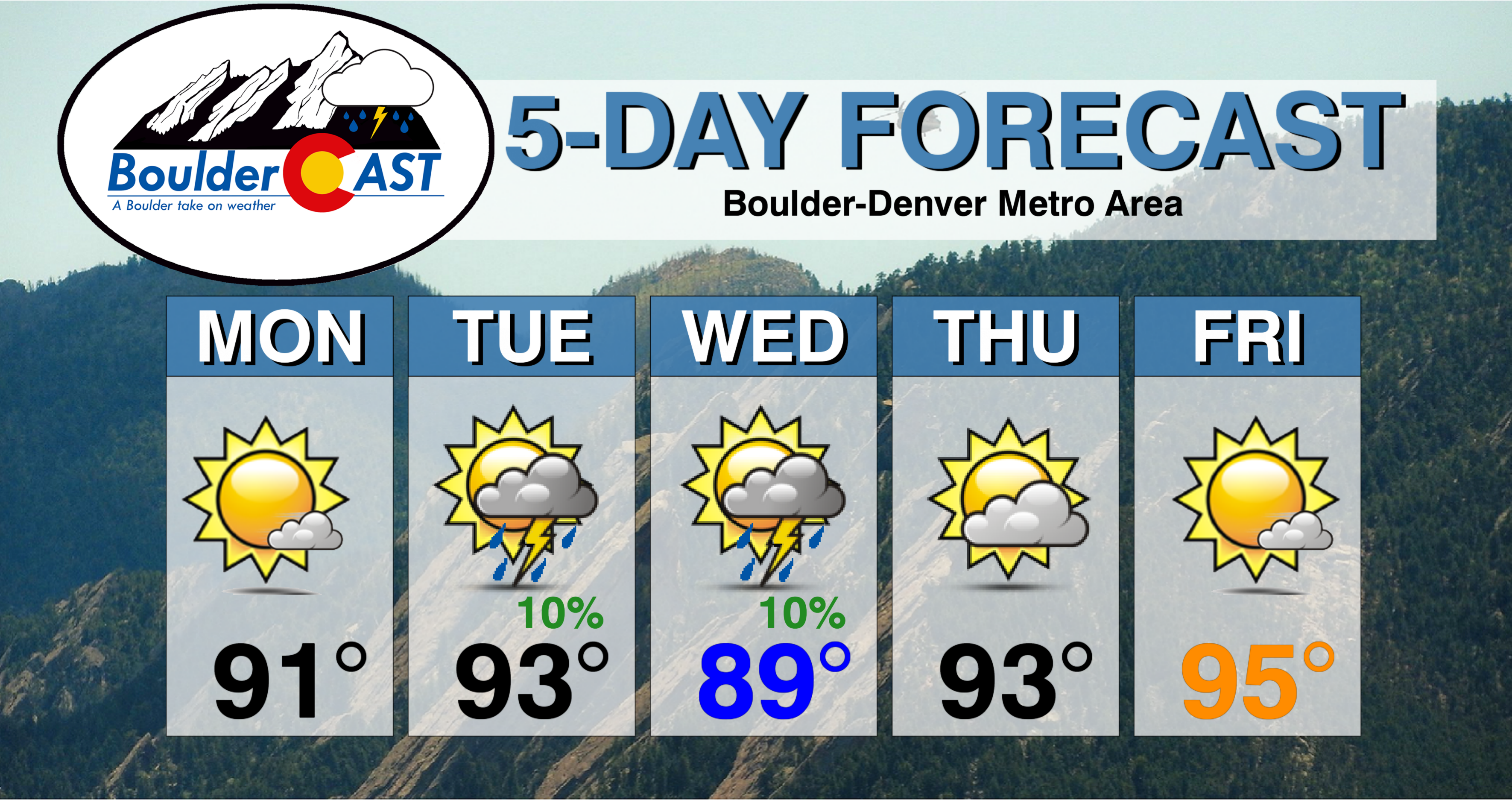
The weather pattern for the week ahead will exhibit shades of the middle of summer with a ridge of high pressure parked across the south-central United States. As a result, temperatures in the Metro area will soar into the 90’s with only limited chances for rainfall through the week. This forecast doesn’t bode well for the meager snowpack remaining across the High Country.
Ridging will dominate our weather this week….simple as that. The GFS 500 mb height anomaly animation below shows the developing ridge will only strengthen across Colorado heading through the week.
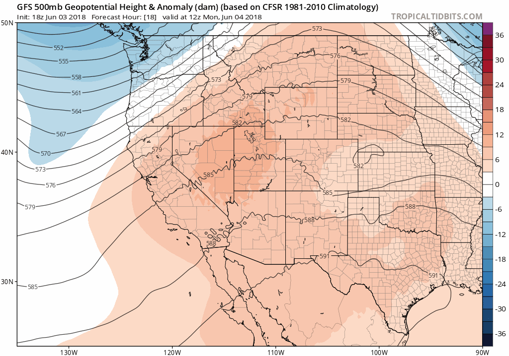
GFS 500 mb height anomaly animation covering Monday through Saturday this week. Notice the stationary ridge intensifying through the week.
The axis of the ridge will remain near or just east of Denver. This precise positioning will not allow much in the way of subtropical moisture to funnel into our region. Because of this, afternoon thunderstorms will generally be hard to come by. Look for just isolated afternoon and early evening thunderstorms on Tuesday and Wednesday, aided by lift from small-scale disturbances embedded in the southwest flow. The 500 mb map below shows some embedded energy Wednesday evening moving across eastern Colorado.
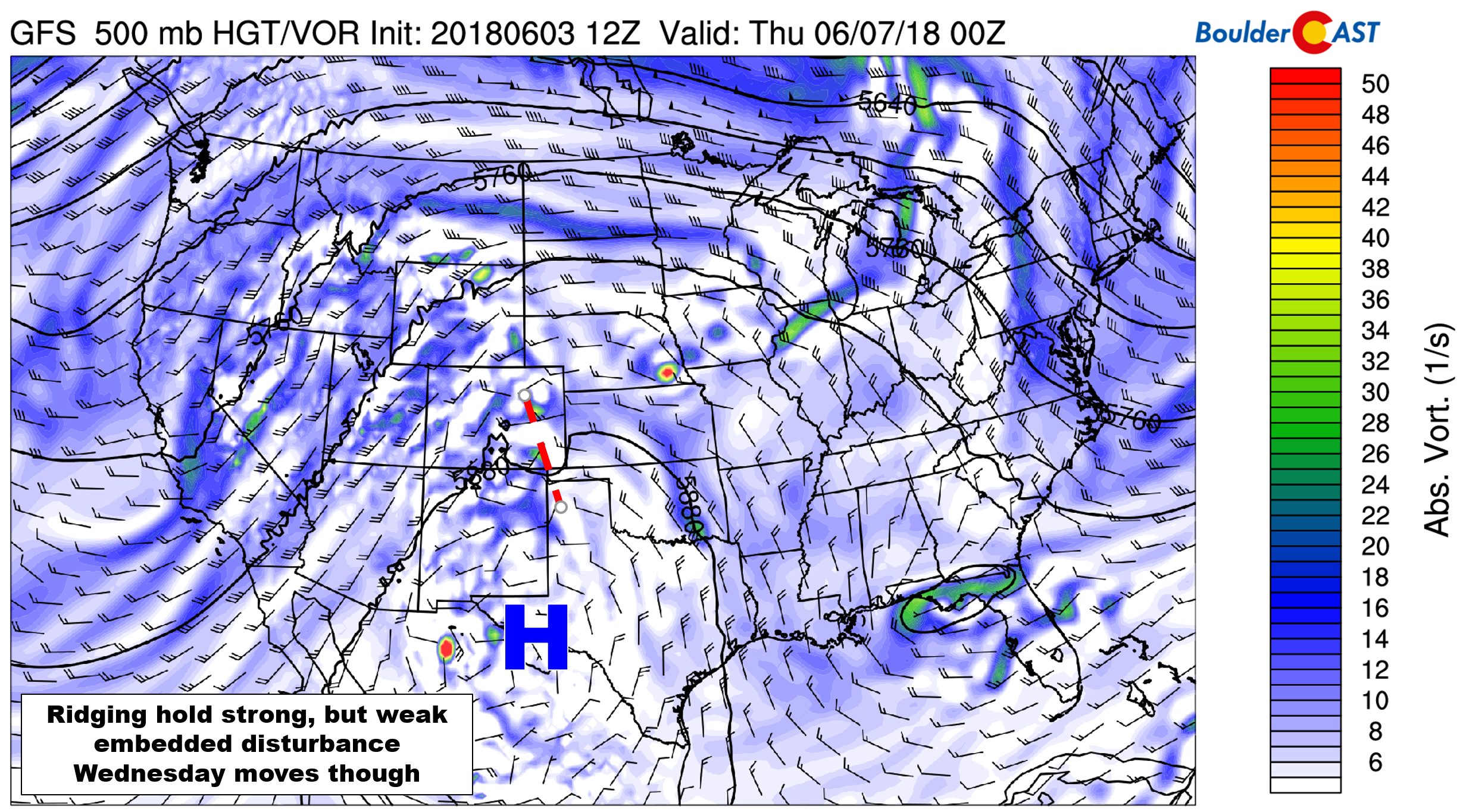
GFS 500 mb vorticity map for Wednesday evening
One cause for concern is across far northeastern Colorado where low-level Gulf of Mexico moisture will be present on Wednesday along with decent shear. At this time, it looks as though severe thunderstorms will be possible northeast of Denver into Nebraska, with large hail and strong straight-line winds the main concerns on Wednesday. The Front Range should be in the clear for just weak and isolated storms, though.
The ridge will intensity and retrograde to be located directly over the Front Range by Thursday and Friday. With continued hot southwest flow and no rainfall expected, temperatures will warm into the low to middle 90’s both days.
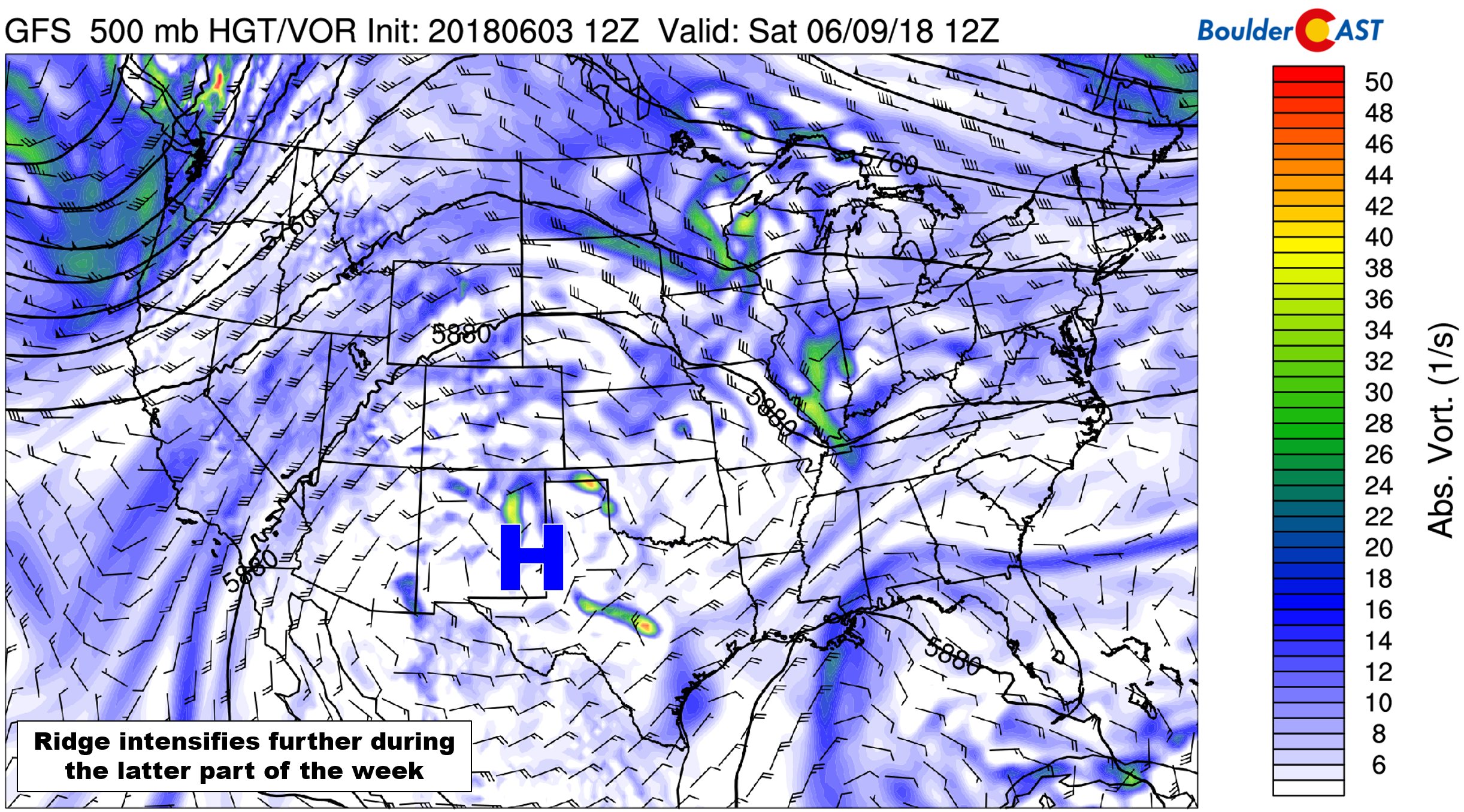
GFS 500 mb vorticity map for Saturday.
Rainfall totals through Friday night are expected to be little to none for the region, maybe a few hundredths of an inch here and there. The dry heat will facilitate the green landscape to shift towards brown this week across the Metro area. This week would be a great time to start watering the lawn if you haven’t begun already!

GFS total precipitation forecast through Friday night.
The ridge is expected to persist right through the upcoming weekend. However, there is indication that moisture will seep into the southwest flow come Saturday and Sunday. While temperatures will likely remain in the 90’s over the weekend, chances of storms should return to our forecast…
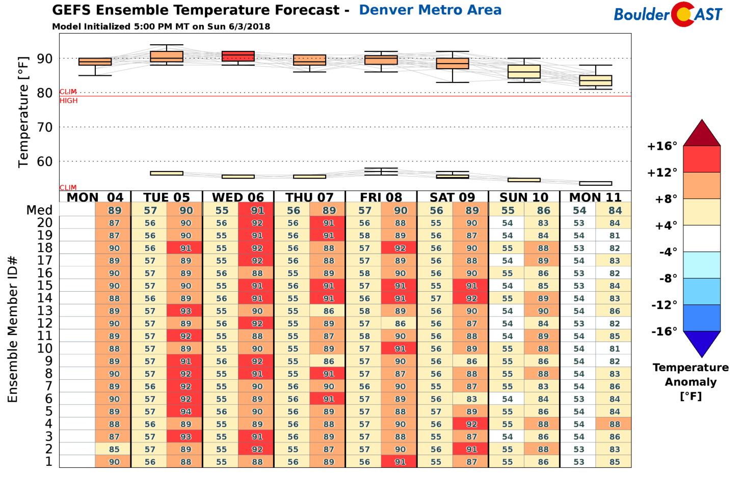
GFS ensemble temperature forecast for the next 8 days. All forecast days show temperatures 100% above average.
The hot weather and lack of cloud cover this week will continue to rapidly melt a bulk of the remaining snowpack in the Mountains.

A photo of Torreys Peak from this past Saturday. I hiked Kelso Mountain, the 13er right next door.
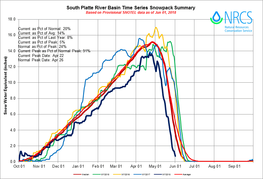
The graphic below shows that the South Platte Basin will be “running out of snow” about two full-weeks ahead of schedule this year. Despite reaching about 90% of peak snowpack in late April, a warmer than normal May led to a steep decline over the past few weeks. Subsequently, streams and rivers around the Front Range are raging rapids right now.
Stay cool and have a great week!

Forecast Specifics:
Monday: Mostly sunny with highs near 90 across Plains and in the middle 70’s in the Foothills.
Tuesday: Mostly sunny skies to become partly cloudy with isolated storms in the late afternoon to early evening. Highs in the lower 90’s on the Plains with upper 70’s in the Foothills.
Wednesday: Partly to mostly cloudy skies with isolated afternoon and evening thunderstorms. Storms will be more numerous and could turn severe northeast of Denver towards Nebraska. Highs in the upper 80’s on the Plains and middle 70’s in the Foothills.
Thursday: Partly cloudy and hot with highs in the lower 90’s for the Plains with upper 70’s in the Foothills.
Friday: Mostly sunny and hot with highs in the low to middle 90’s on the Plains and near 80 in the Foothills.
High Country: It will be a warm weak across the higher elevations with snowpack continuing to rapidly melt. Isolated afternoon thunderstorms are possible on Tuesday and Wednesday, with dry conditions Monday and Thursday. Moisture may rebound high enough by Friday afternoon for a few storms to form as well, particularly across southern Colorado.
DISCLAIMER: This weekly outlook forecast was created Monday morning and covers the entire upcoming week. Accuracy will decrease as the week progresses as this post is NOT updated. To receive daily updated forecasts, subscribe to BoulderCAST Premium.

.
Share our forecast!
.


You must be logged in to post a comment.