With April come and gone, we are now fully entrenched in the Spring season here in the Front Range. We take a look at current trends, past climatology, and offer our prediction for the month of May in northeast Colorado.
May climatology
Spring is an interesting time east of the Rockies. A combination of favorable storm tracks, cool Canadian air, and Gulf of Mexico moisture makes the weather in March, April, and May somewhat of a grab bag. In springtime, the winter storm track is still over the region and moisture becomes widespread enough to produce semi-frequent, significant precipitation (like that rain we had yesterday!). This combination makes this the wettest time of the year. In fact, May is Boulder’s wettest month, just beating out April, registering 3.05″ on average. The window for measurable snow for the Plains slams shut very rapidly toward the latter half of April, but May snow is not uncommon. In fact, it has been recorded 15 out of the last 17 years in Boulder, so don’t put those shovels away just yet! By now though, warmer air is slowly regaining its grasp on Colorado. As a result, the bulk of May precipitation generally falls as the liquid variety.
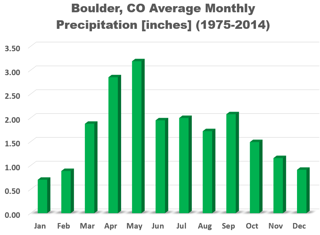
Monthly mean precipitation for Boulder. May is the wettest month of them all!
May also sees temperatures trending upward. The average high/low on May 1st is 65/39 degrees. By May 31st, it is 73/48 degrees. The hottest May day occurred on May 29, 2003 at 95 degrees, while the coldest temperature measured in May occurred on the 2nd in 2013 at 17 degrees. The takeaway: May in Denver can feel like July……or January, depending on the mood of Mother Nature at the time.
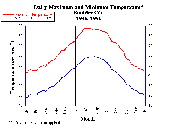
The annual cycle of mean high and low temperatures for Boulder
May also typically marks the official beginning of the growing season, as the mean and median date of the last frost occur in the first few days of May (see below).
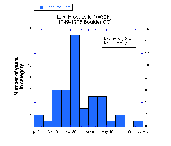
Occurrence of the last 32 degree temperature by date for Boulder. On average, the last frost is May 3rd. Unbelievably, the latest frost on record occurred on June 3rd. Fun fact: The latest measurable snowfall in Boulder occurred on June 12th, 1947.
Finally, May brings a profound jump in severe weather nationwide, including Colorado. However, Boulder in particular is protected from the bulk of severe weather due to its close proximity to the mountains. Therefore, we are mostly immune to this trend, with only 1 out of the 10 confirmed tornadoes in Boulder County since 1950 having occurred in the fifth month of the year.
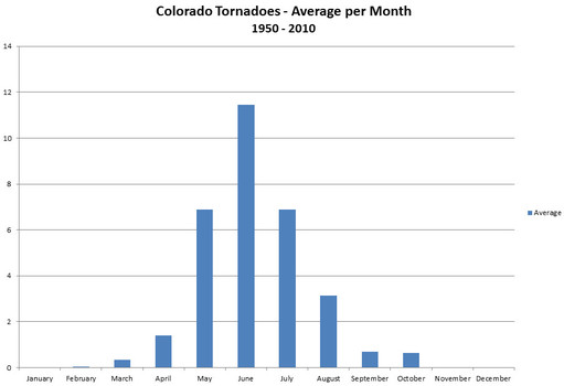
Average tornadoes observed by month in the entire state of Colorado. Data provided by NCDC.
So what should we expect this May?
Looking at the GFS and European ensembles, it looks like we should expect ridging to dominate the country through at least mid-May. Under the pattern, we would expect warm and generally dry conditions to prevail across Colorado. At the tail-end of the animation below, the GFS ensemble is indicating a potential trough coming ashore into the Pacific Northwest. This is in the May 16 to 20 timeframe…which is still quite a ways out with very large forecast uncertainty.
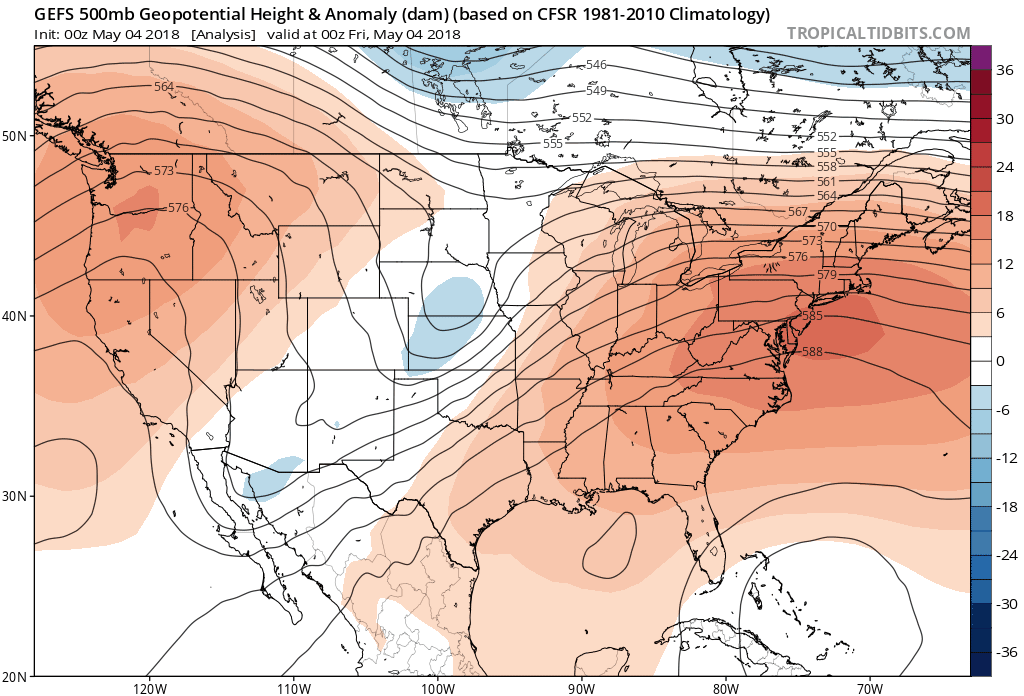
Animation of 500 mb height anomaly from May 4 to 20, 2018 from the GFS ensembles.
The long-range guidance of the CFS climate model suggests that the Front Range will be warmer than normal for the month of May (below on left). This warm signal is actually present for most of North America, resulting from the ridgy pattern shown in the animation above. The CFS model is indicating a wetter than normal month of May for the Front Range (below on right). However, this map includes the significant precipitation which has already fallen this week. To us, nothing moving forward (after May 4th) suggests we should expect much precipitation in the near-term at least.
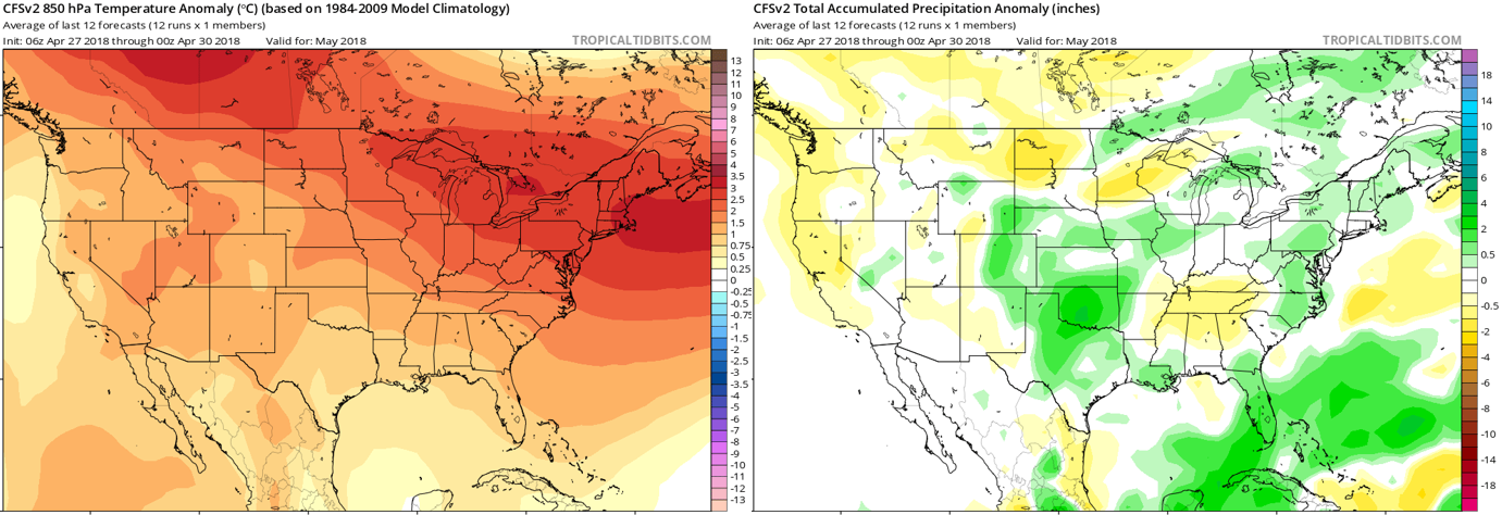
May outlook for temperature (left) and precipitation (right) as forecasted by the CFS climate model.
NOAA’s Climate Prediction Center is has the warm bias in the their forecast as well covering the entire Continental United States…including a greater than 50% chance of above normal temperature in Colorado. They also include our region in slightly elevated odds of above normal precipitation for May 2017 (again, this includes significant precipitation which has already fallen this month).
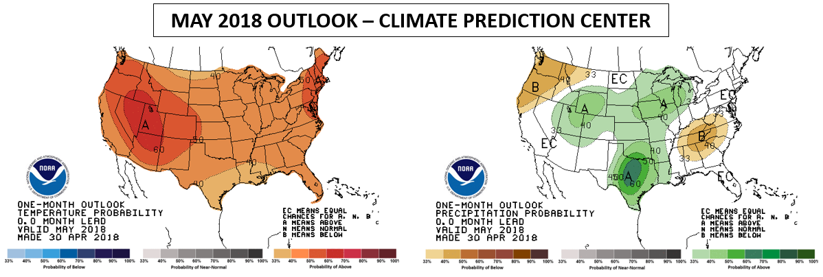
May outlook issued by the CPC for temperature (left) and precipitation (right).
Here is a quote from the CPC discussion, where they also mention that killer ridge set to take over across the country:
THE LATEST MODEL GUIDANCE FROM THE CFS AND OUR OFFICIAL WEEK-2 AND WEEK 3-4 FORECAST PRODUCTS ALL SUPPORT A GENERAL TILT TOWARD ABOVE-NORMAL TEMPERATURES OVER THE ENTIRE CONUS. THE ODDS OF ABOVE-NORMAL TEMPERATURES ARE THE GREATEST OVER PARTS OF THE INTERIOR WEST, WHERE A MAJOR, PROLONGED WARMUP IS FORECAST FROM ABOUT MAY 6 ONWARD.
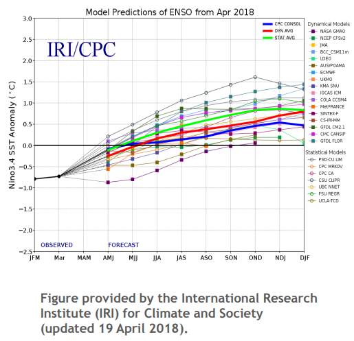
Blending everything we are seeing, we are forecasting above normal temperatures and a wetter than normal May this year. With our statewide snowpack currently in a perilous state, the added precipitation is more than welcomed! For what it’s worth, there is also growing speculation that El Niño will make its return this fall. Though admittedly, almost every single spring following La Niña, the models predict El Niño the next year. There is notoriously low forecast skill with ENSO this time of year. That is a topic for another post, however. For now, enjoy the rest of our rainiest month!
.


You must be logged in to post a comment.