
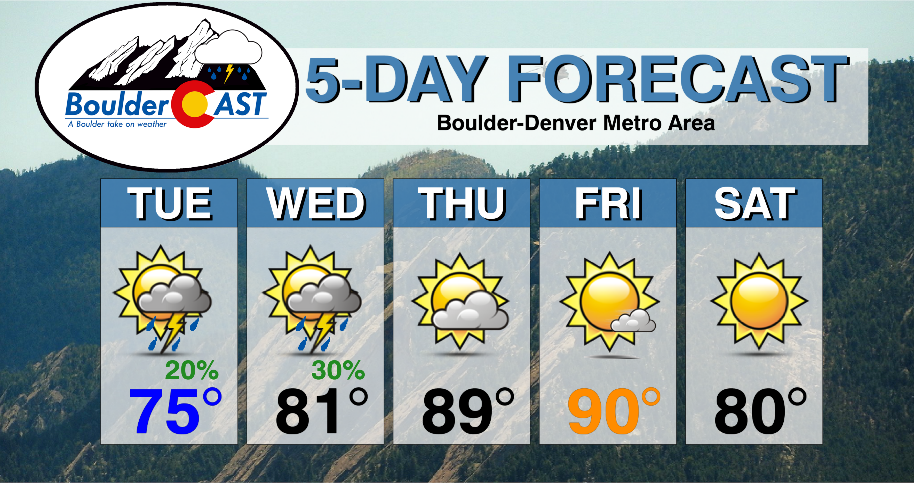
After a long Memorial day weekend, the shortened work-week starts off cooler with thunderstorms, but drier and warmer weather lies ahead. Read on for more details.
Tuesday pleasant, stormy Wednesday
We hope you had a wonderful holiday weekend, whatever your plans were! This short work-week starts off similar to Memorial Day, on the cool side, albeit warmer than Monday. The below image shows the pattern in place this afternoon. The remnants of Subtropical Storm Alberto have pushed northward into Tennessee. The system which brought us strong thunderstorms yesterday has moved northeast into western Nebraska. Although westerly downslope flow will be in place today with the system to our east, the chance of storms will exist this afternoon to early evening with moisture still in place. That chance, however, will only be about 20% from 2 PM to 8 PM. Storms are likely to remain below severe levels. Expect middle 70’s for highs today.
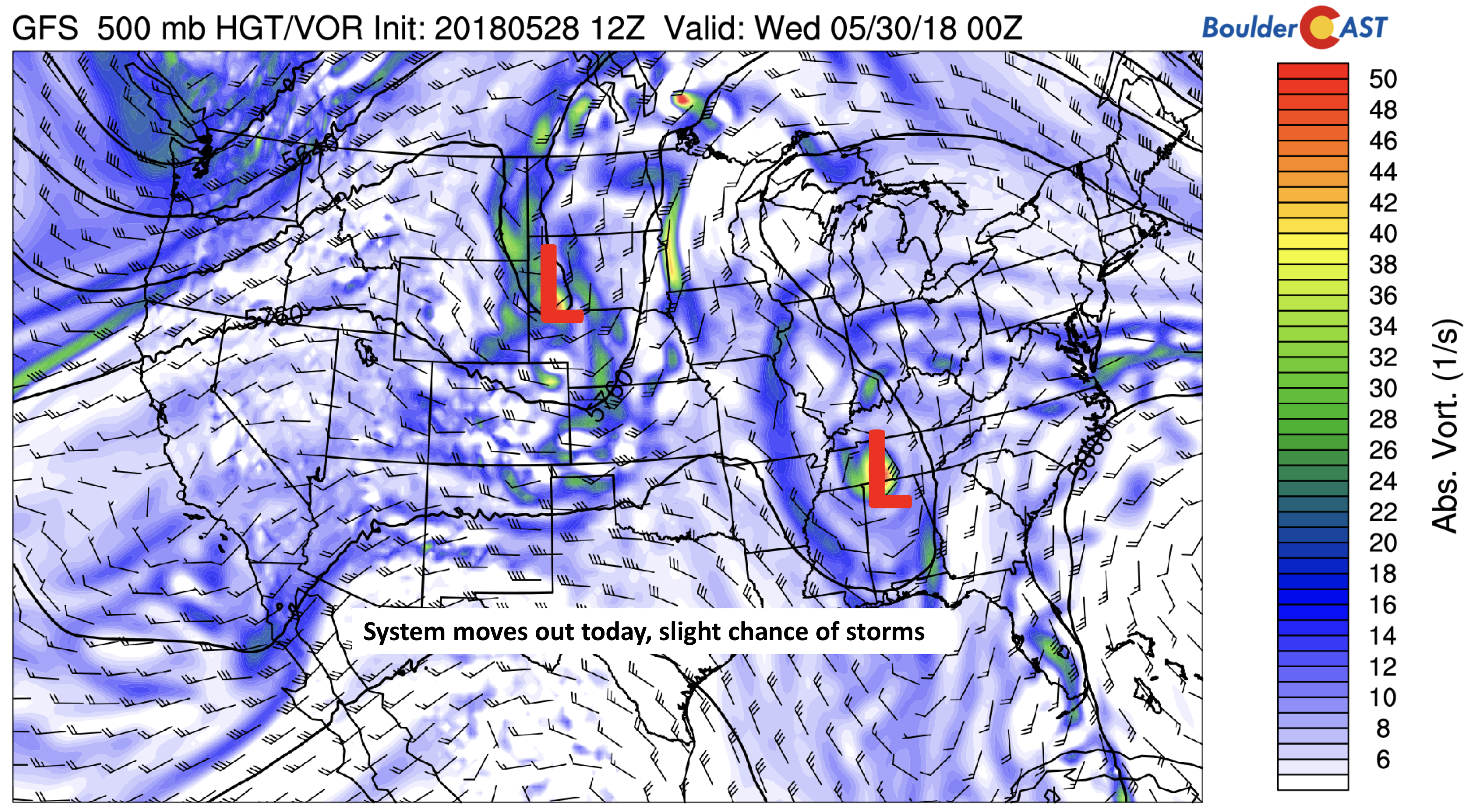
GFS 500 mb absolute vorticity today
On Wednesday, southwest flow will return once again. That will help elevate storm chances to about 30% during the afternoon and evening. These storms will be capable of heavy rainfall, lightning, and small hail. At the same time, warmer air will build back in, with highs reaching the lower 80’s in most areas.
Thursday and Friday are hot!
The heat returns for the latter part of the week, along with a trend toward drier conditions. Below shows the mid-level pattern on Thursday and Friday. On Thursday, southwest flow will be prevalent across the Desert Southwest, thanks to a trough over California. By Friday, this trough moves into Colorado, with southwest flow remaining.
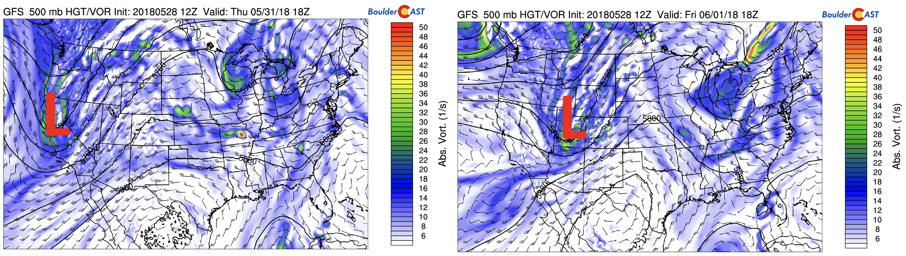
GFS 500 mb absolute vorticity Thursday (left) and Friday (right)
There will also be a hot airmass that will return back into the state. This will be similar to late last week where temperatures were in the lower 90’s. The low-level temperature pattern is shown below for the United States. While somewhat cooler air is progged for the Eastern U.S. behind a weak cold front, temperatures above 25 degrees Celsius at the surface are on-tap for the Denver Metro. That should put us into the upper 80’s to lower 90’s on Thursday and Friday.
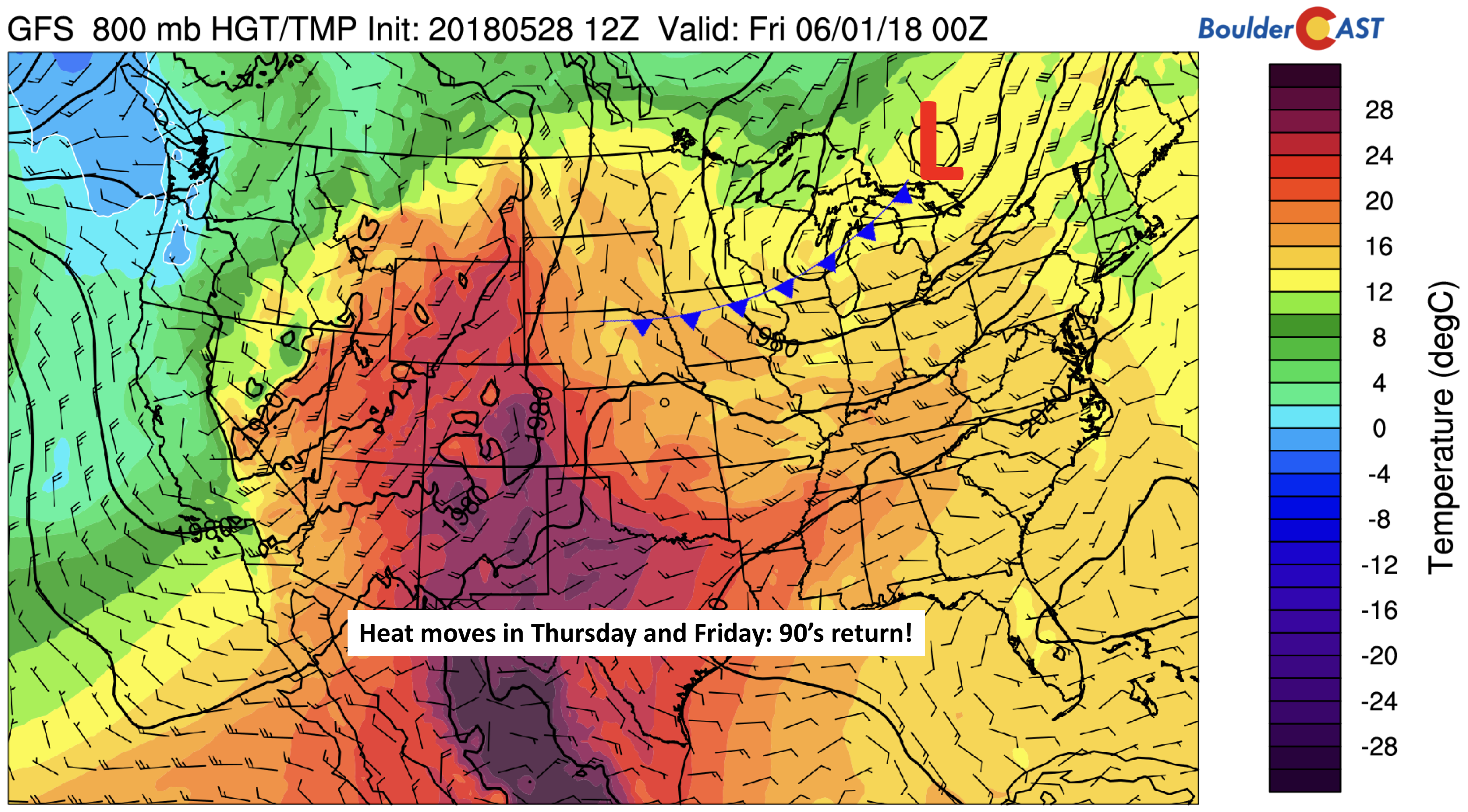
GFS 800 mb temperature on Thursday
The warmth will further be fueled by lots of sunshine and a lack of cloud cover. The moisture gets scoured out from Thursday to Friday thanks to dry winds pushing in from the Desert Southwest (see red circled regions below). The precipitable water dips to around 0.1″ by Friday, essentially eliminating the threat of unsettled weather.
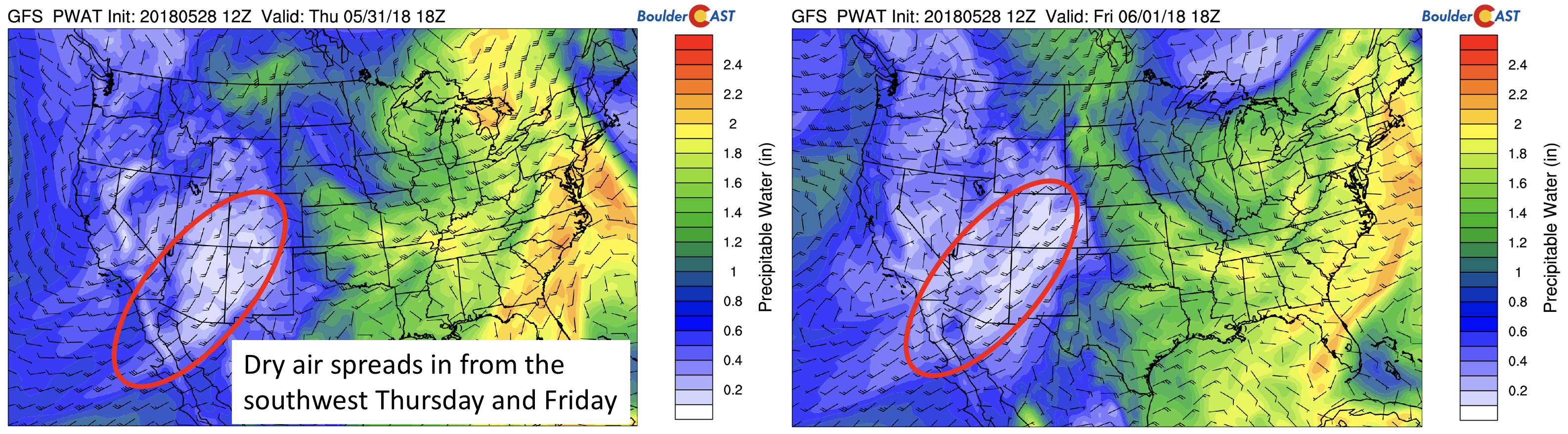
GFS precipitable water (in) for Thursday (left) and Friday (right), along with mid-level winds.
Weak cold front Saturday
A weak cold front appears to move through the region late Friday night in response to the trough on Friday pushing through. This is shown below, which indicates more northerly winds pushing into Colorado. That should help bring a somewhat cooler start to the upcoming weekend into the lower 80’s. If it arrives a little sooner, Friday may not be quite as hot either.
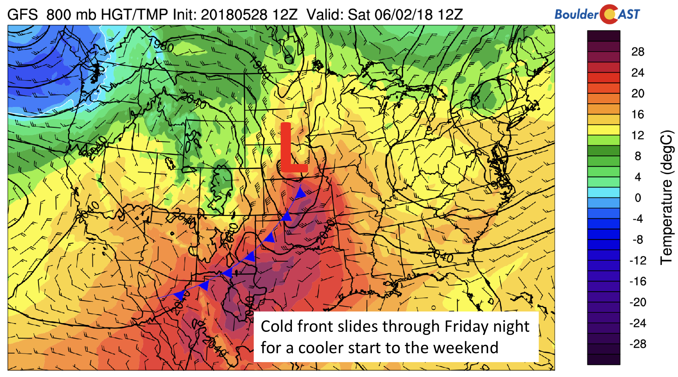
GFS 800 mb temperature on Saturday morning
Enjoy the short week….and don’t forget to follow the link below to enter our “Summer Heat” Forecast Contest….Friday could very well be our first 90-degree day included in the contest!
Forecast Specifics:
Tuesday: Mostly sunny skies to become partly cloudy with isolated storms in the late afternoon to early evening. The chance of storms will be about 20% from 2 to 8 PM. Highs in the middle 70’s on the Plains with middle 60’s in the Foothills.
Wednesday: Morning sunshine, then increasing afternoon clouds with scattered thunderstorms in the late afternoon to early evening. Storms could produce heavy rainfall. Highs near 80 on the Plains and lower 70’s in the Foothills.
Thursday: Sunny and hot with highs in the upper 80’s to near 90 for the Plains and upper 70’s in the Foothills.
Friday: Mostly sunny and hot with highs in the lower 90’s on the Plains and near 80 in the Foothills.
Saturday: Sunny and cooler with highs near 80 degrees on the Plains and in the upper 60’s in the Foothills.
High Country: Scattered storms appear likely both today and Wednesday. Thursday and Friday are much drier thanks to warm and dry air pushing in from the Desert Southwest. If your are planning to do any hiking, be sure to check out our SummitCAST page for the latest forecasts.
DISCLAIMER: This weekly outlook forecast was created Tuesday morning and covers the entire upcoming week. Accuracy will decrease as the week progresses as this post is NOT updated. To receive daily updated forecasts, subscribe to BoulderCAST Premium.

.
Share our forecast!
.


You must be logged in to post a comment.