We’re excited to announce that the first batch of lower elevation hikes have just been added to SummitCAST! Read on for details on which hikes are included and where you can access the new additions.
Category: Forecast (Page 124 of 169)

Much warmer and sunnier weather is expected this week. No major storm systems will be impacting the state of Colorado. However, thanks to elevated moisture, there will be a daily chance of afternoon and evening thundershowers early in the week.
Premium Storm Update (Fri May 18 at 7:30 AM): We discuss the chances that the incoming storm could come in stronger and cause flooding across the region on Saturday. Plus, an update on the potential severe storm risk on Friday. READ NOW
—
We’re only half way through May, but many locations across the Front Range have already exceeded their normal precipitation for the entire month. This wet trend continues with another round of severe thunderstorms and widespread soaking rainfall this weekend.

Well, they say April showers bring May flowers, but what do May showers bring?? The forecast for the week will feature a similar pattern to what we have experienced over the weekend. The week can be summed up in a few words: stormy at the beginning and end of the week, with slightly drier conditions in the middle.
We warned you on Monday about the potential for the weather to turn gloomier just in time for the weekend. While that forecast is indeed going to materialize, the track of the cut-off storm system has trended further west through the week. This means it won’t be quite as cold or soggy as initially expected across Colorado. Nonetheless, the unseasonably warm and dry pattern we’ve experienced for the last week is now over. Cooler weather and chances for rain are here to stay.
A large-scale pattern shift will continue to facilitate warm and dry weather for the Front Range through much of the week. Things get messy just in time for the weekend, however. We’re tracking a storm that will bring much colder temperatures, lots of rain, and higher elevation snow.
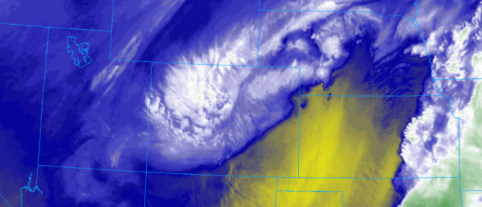
This week’s storm produced a hefty amount of precipitation to the entire Front Range. We provide a recap of the storm’s rain and snow, and also discuss a major pattern shift set to impact the western United States soon.

Live View of Boulder

Current Conditions

Live Radar

Latest Smoke Forecast

Recent Premium Posts

BoulderCAST Daily – Fri 07/17/26 | Hot and dry continues through the weekend
🥵 Heat tightens its grip this weekend — Ridge strengthens slightly over the …
This Weekend in Colorado Weather: Several More Scorching Days Ahead Before the Long‑Awaited Monsoon Pattern Arrives
☀️ Persistent heat continues — Low to mid‑90s through Saturday, spiking towards the …
BoulderCAST Daily – Wed 07/15/26 | The Ridge Rules the Rockies as Hot, Dry Pattern Holds Firm
🔥 Heat dome setup continues — A strong, stationary 500 mb ridge keeps …
3-Day Forecast

Trending Content

© 2026 Front Range Weather, LLC